

Sahel drought
Encyclopedia
Sahel
The Sahel is the ecoclimatic and biogeographic zone of transition between the Sahara desert in the North and the Sudanian Savannas in the south.It stretches across the North African continent between the Atlantic Ocean and the Red Sea....
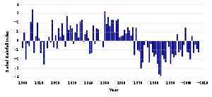
drought was a series of historic droughts, beginning in at least the 17th century affecting the Sahel region, a climate zone sandwiched between the African savanna grasslands to the south and the Sahara desert to the north, across West
West Africa
West Africa or Western Africa is the westernmost region of the African continent. Geopolitically, the UN definition of Western Africa includes the following 16 countries and an area of approximately 5 million square km:-Flags of West Africa:...
and Central Africa. While the frequency of drought in the region is thought to have increased from the end of the 19th century, three long droughts have had dramatic environmental and societal effects upon the Sahel nations. Famine followed severe droughts in the 1910s, the 1940s, and the 1960s, 70s and 80s, although a partial recovery occurred from 1975-80. While at least one particularly severe drought has been confirmed each century since the 17th century, the frequency and severity of recent Sahelian droughts stands out. Famine and dislocation on a massive scale—from 1968 to 1974 and again in the early and mid 1980s—was blamed on two spikes in the severity of the 1960-1980s drought period. From the late 1960s to early 1980s famine
Famine
A famine is a widespread scarcity of food, caused by several factors including crop failure, overpopulation, or government policies. This phenomenon is usually accompanied or followed by regional malnutrition, starvation, epidemic, and increased mortality. Every continent in the world has...
killed a 100,000 people, left 750,000 dependent on food aid, and affected most of the Sahel's 50 million people. The economies, agriculture, livestock and human populations of much of Mauritania
Mauritania
Mauritania is a country in the Maghreb and West Africa. It is bordered by the Atlantic Ocean in the west, by Western Sahara in the north, by Algeria in the northeast, by Mali in the east and southeast, and by Senegal in the southwest...
, Mali
Mali
Mali , officially the Republic of Mali , is a landlocked country in Western Africa. Mali borders Algeria on the north, Niger on the east, Burkina Faso and the Côte d'Ivoire on the south, Guinea on the south-west, and Senegal and Mauritania on the west. Its size is just over 1,240,000 km² with...
, Chad
Chad
Chad , officially known as the Republic of Chad, is a landlocked country in Central Africa. It is bordered by Libya to the north, Sudan to the east, the Central African Republic to the south, Cameroon and Nigeria to the southwest, and Niger to the west...
, Niger
Niger
Niger , officially named the Republic of Niger, is a landlocked country in Western Africa, named after the Niger River. It borders Nigeria and Benin to the south, Burkina Faso and Mali to the west, Algeria and Libya to the north and Chad to the east...
and Burkina Faso
Burkina Faso
Burkina Faso – also known by its short-form name Burkina – is a landlocked country in west Africa. It is surrounded by six countries: Mali to the north, Niger to the east, Benin to the southeast, Togo and Ghana to the south, and Côte d'Ivoire to the southwest.Its size is with an estimated...
(known as Upper Volta
Republic of Upper Volta
The Republic of Upper Volta was established on December 11, 1958, as a self-governing colony within the French Community. Before attaining autonomy it had been French Upper Volta and part of the French Union. On August 5, 1960 it attained full independence from France.Thomas Sankara came to power...
during the time of the drought) were severely impacted. As disruptive as the droughts of the late 20th century were, evidence of past droughts recorded in Ghanaian lake sediments suggest that multi-decadal megadrought
Megadrought
A megadrought is a prolonged drought lasting two decades or longer. Past megadroughts have been associated with persistent multiyear La Niña conditions . The term megadrought is generally used to describe the length of a drought, and not its severity...
s were common in West Africa over the past 3,000 years and that several droughts lasted far longer and were far more severe.hahahahaha
Previous Sahel droughts
Because the Sahel's rainfall is heavily concentrated in a very small period of the year, the region has been prone to dislocation when droughts have occurred ever since agricultureAgriculture
Agriculture is the cultivation of animals, plants, fungi and other life forms for food, fiber, and other products used to sustain life. Agriculture was the key implement in the rise of sedentary human civilization, whereby farming of domesticated species created food surpluses that nurtured the...
developed around 5,000 years ago. The Sahel is marked by rainfalls of less than 100 mm a year, all of which occurs in a season which can run from several weeks to two months.
Despite this vulnerability, the history of drought and famine in the Sahel do not perfectly correlate. While modern scientific climate and rainfall studies have been able to identify trends and even specific periods of drought in the region, oral and written records over the last millennium do not record famine in all places at all times of drought. One 1997 study, in attempting to map long scale rainfall records to historical accounts of famine in Northern Nigeria, concluded that "the most disruptive historical famines occurred when the cumulative deficit of rainfall fell below 1.3 times the standard deviation of long-term mean annual rainfall for a particular place." The 1982-84 period, for instance, was particularly destructive to the pastoral Fula people
Fula people
Fula people or Fulani or Fulbe are an ethnic group spread over many countries, predominantly in West Africa, but found also in Central Africa and Sudanese North Africa...
of Senegal, Mali and Niger, and the Tuareg of northern Mali and Niger. The populations had not only suffered in the 1968-74 period, but the inability of many to rebuild herds destroyed a decade earlier, along with factors as various as the shift of political power to settled populations with independence in the 1960s, Senegalese-Mauritanian border relations, and Niger's dependence upon falling world uranium prices coinciding in a destructive famine.
600–700 CE
Surviving contemporary records of climate in the Sahel begin with early MuslimMuslim
A Muslim, also spelled Moslem, is an adherent of Islam, a monotheistic, Abrahamic religion based on the Quran, which Muslims consider the verbatim word of God as revealed to prophet Muhammad. "Muslim" is the Arabic term for "submitter" .Muslims believe that God is one and incomparable...
travellers in the early Medieval Warm Period
Medieval Warm Period
The Medieval Warm Period , Medieval Climate Optimum, or Medieval Climatic Anomaly was a time of warm climate in the North Atlantic region, that may also have been related to other climate events around the world during that time, including in China, New Zealand, and other countries lasting from...
. These suggest that Sahel rainfall was relatively low in the seventh and 8th centuries and then increased substantially from about 800 AD. There was a decline in rainfall from about 1300 AD, but an increase again around 200 years later.are you seriuosly reading this? Go read about condoms.
1400–1750
According to a study of West African drought based on Ghanaian lake sediments (not eyewitness historical accounts) published in the journal Science in April 2009:
"The most recent of these [multicentury droughts] occurred between 1400 and 1750 CE (550 to 200 yr B.P.), similar in timing to the Little Ice Age (LIA, 1400 to 1850 CE), a well-known interval when Northern Hemisphere temperatures were cooler than at present. In contrast with earlier studies, which reconstructed wetter conditions in East Africa during this period, evidence from Lake BosumtwiLake BosumtwiLake Bosumtwi , situated within an ancient meteorite impact crater, is approximately 8 km across and the only natural lake in Ghana. It is situated about 30 km south-east of Kumasi and is a popular recreational area. There are about 30 villages near the lake, with a combined population of...
supports more recent studies suggesting that this interval was dry. Evidence for LIA drought is not restricted to Africa, however. Records from throughout the tropics, including the western Pacific warm pool, the Arabian Sea, continental Asia, and tropical South America all show evidence for dry conditions during this time period.".
1640
The first major historically recorded droughtDrought
A drought is an extended period of months or years when a region notes a deficiency in its water supply. Generally, this occurs when a region receives consistently below average precipitation. It can have a substantial impact on the ecosystem and agriculture of the affected region...
in the Sahel occurred around 1640, and a major drought after generally wet conditions occurred, based on the reports of European travellers, during the 1680s.
1740s and 50s
This cycle of several wet decades followed by a drought was repeated during the 18th century. These droughts killed hundreds of thousands of people in the 1740s to 1750s. The 1740s and 1750s was recorded in chronicles of what is today Northern Nigeria, Niger and Mali as the "Great Famine", the worst for at least 200 years prior. It caused massive dislocation of the Sahelian states of the time, but also disrupted the Trans Saharan trade routes to North Africa and Europe.1830s
Around 1790 dry conditions similar to those of the late 20th century set in and continued until around 1870. After that, a very wet period set in for around 25 years, followed by a return to drier conditions. While the drying begun around 1895 and caused its first large famine only in the early 20th century, the 1820s and 1830s saw a 12 to 15 year drought and regional instances of major famine from Senegal to Chad. Historical records suggest this drought caused a large-scale emigration from the Bornu EmpireBornu Empire
The Bornu Empire was an African state of Nigeria from 1396 to 1893. It was a continuation of the great Kanem Empire founded centuries earlier by the Sayfawa Dynasty...
, contributing to its rapid decline in the 19th century. In what is now northern Senegal, the Kingdom of Fouta Tooro
Kingdom of Fouta Tooro
The Kingdom of Fouta Tooro or the Kingdom of Fuua Tooro was a pre-colonial West African state of the Fula-speaking people centered around the middle valley of the Senegal River...
was struck by a famine caused by the failure of 1833's rainy season, leading to waves of famine until 1837.if you are reading this you are a dick
Early 20th century droughts
The first rain gauges in the Sahel date from 1898 and they reveal that a major drought, accompanied by large-scale famine, in the 1910s, followed by wet conditions during the 1920s and 1930s reaching a peak with the very wet year of 1936. The 1940s saw several minor droughts — notably in 1949 — but the 1950s were consistently wet and expansion of agriculture to feed growing populations characterised this decade and many have thought it contributed to the severity of the subsequent Sahel droughtsLate 20th century droughts
Both Burkina FasoBurkina Faso
Burkina Faso – also known by its short-form name Burkina – is a landlocked country in west Africa. It is surrounded by six countries: Mali to the north, Niger to the east, Benin to the southeast, Togo and Ghana to the south, and Côte d'Ivoire to the southwest.Its size is with an estimated...
, northern Nigeria
Nigeria
Nigeria , officially the Federal Republic of Nigeria, is a federal constitutional republic comprising 36 states and its Federal Capital Territory, Abuja. The country is located in West Africa and shares land borders with the Republic of Benin in the west, Chad and Cameroon in the east, and Niger in...
, southern Niger
Niger
Niger , officially named the Republic of Niger, is a landlocked country in Western Africa, named after the Niger River. It borders Nigeria and Benin to the south, Burkina Faso and Mali to the west, Algeria and Libya to the north and Chad to the east...
, far northern Camaroon (near Lake Chad
Lake Chad
Lake Chad is a historically large, shallow, endorheic lake in Africa, whose size has varied over the centuries. According to the Global Resource Information Database of the United Nations Environment Programme, it shrank as much as 95% from about 1963 to 1998; yet it also states that "the 2007 ...
), central Chad
Chad
Chad , officially known as the Republic of Chad, is a landlocked country in Central Africa. It is bordered by Libya to the north, Sudan to the east, the Central African Republic to the south, Cameroon and Nigeria to the southwest, and Niger to the west...
, the Sudan
Sudan
Sudan , officially the Republic of the Sudan , is a country in North Africa, sometimes considered part of the Middle East politically. It is bordered by Egypt to the north, the Red Sea to the northeast, Eritrea and Ethiopia to the east, South Sudan to the south, the Central African Republic to the...
, Ethiopia
Ethiopia
Ethiopia , officially known as the Federal Democratic Republic of Ethiopia, is a country located in the Horn of Africa. It is the second-most populous nation in Africa, with over 82 million inhabitants, and the tenth-largest by area, occupying 1,100,000 km2...
, Eritrea
Eritrea
Eritrea , officially the State of Eritrea, is a country in the Horn of Africa. Eritrea derives it's name from the Greek word Erethria, meaning 'red land'. The capital is Asmara. It is bordered by Sudan in the west, Ethiopia in the south, and Djibouti in the southeast...
and Somalia
Somalia
Somalia , officially the Somali Republic and formerly known as the Somali Democratic Republic under Socialist rule, is a country located in the Horn of Africa. Since the outbreak of the Somali Civil War in 1991 there has been no central government control over most of the country's territory...
had struggled with dwindling rain fall since the 1960s. Famines like the 1984–1985 famine in Ethiopia was caused by this from the mid 1970s to the early 1990s, when the rain fall began to return to normal in Ethiopia and the Sudan.
On May 12 and 26, both Mauritania
Mauritania
Mauritania is a country in the Maghreb and West Africa. It is bordered by the Atlantic Ocean in the west, by Western Sahara in the north, by Algeria in the northeast, by Mali in the east and southeast, and by Senegal in the southwest...
, the Sénégal River Area and neighbouring parts of both Senegal
Senegal
Senegal , officially the Republic of Senegal , is a country in western Africa. It owes its name to the Sénégal River that borders it to the east and north...
and Mali
Mali
Mali , officially the Republic of Mali , is a landlocked country in Western Africa. Mali borders Algeria on the north, Niger on the east, Burkina Faso and the Côte d'Ivoire on the south, Guinea on the south-west, and Senegal and Mauritania on the west. Its size is just over 1,240,000 km² with...
faced both a drought and famine.
2010 Sahel drought
In June to August, 2010, famine struck the Sahel. Niger's crops failed to mature in the heat which resulted in famineFamine
A famine is a widespread scarcity of food, caused by several factors including crop failure, overpopulation, or government policies. This phenomenon is usually accompanied or followed by regional malnutrition, starvation, epidemic, and increased mortality. Every continent in the world has...
. 350,000 faced starvation and 1,200,000 were at risk of famine
Famine
A famine is a widespread scarcity of food, caused by several factors including crop failure, overpopulation, or government policies. This phenomenon is usually accompanied or followed by regional malnutrition, starvation, epidemic, and increased mortality. Every continent in the world has...
. In Chad, the temperature reached 47.6°C (117.7°F) on June 22 in Faya-Largeau
Faya-Largeau
Located in the Sahara, Faya's climate is classed as hot desert on the Köppen climate classification. It experiences hot winters and very hot summers with the peak average maximum temperature reaching in May and the average minimum reaching its lowest in January at . Rainfall averages out at about...
, breaking a record set in 1961 at the same location. Niger tied its highest temperature record set in 1998, on also June 22, at 47.1°C in Bilma
Bilma
Bilma is an oasis town in north east Niger with a population of around 2,500 people. It lies protected from the desert dunes under the Kaouar Cliffs and is the largest town along the Kaouar escarpment...
. That record was broken the next day, on June 23 when Bilma hit 48.2°C (118.8°F). The hottest temperature recorded in Sudan was reached on June 25, at 49.6°C (121.3°F) in Dongola
Dongola
Dongola , also spelled Dunqulah, and formerly known as Al 'Urdi, is the capital of the state of Northern in Sudan, on the banks of the Nile. It should not be confused with Old Dongola, an ancient city located 80 km upstream on the opposite bank....
, breaking a record set in 1987. Niger reported diarrhoea, starvation, gastroenteritis
Gastroenteritis
Gastroenteritis is marked by severe inflammation of the gastrointestinal tract involving both the stomach and small intestine resulting in acute diarrhea and vomiting. It can be transferred by contact with contaminated food and water...
, malnutrition
Malnutrition
Malnutrition is the condition that results from taking an unbalanced diet in which certain nutrients are lacking, in excess , or in the wrong proportions....
and respiratory diseases kill and sicken may children July 14. The new military junta
Military junta
A junta or military junta is a government led by a committee of military leaders. The term derives from the Spanish language junta meaning committee, specifically a board of directors...
appealed for international food aid and has taken serious steps to calling overseas help since coming to office in February 2010. On July 26 the heat reached near record levels over Chad
Chad
Chad , officially known as the Republic of Chad, is a landlocked country in Central Africa. It is bordered by Libya to the north, Sudan to the east, the Central African Republic to the south, Cameroon and Nigeria to the southwest, and Niger to the west...
and Niger
Niger
Niger , officially named the Republic of Niger, is a landlocked country in Western Africa, named after the Niger River. It borders Nigeria and Benin to the south, Burkina Faso and Mali to the west, Algeria and Libya to the north and Chad to the east...
.
Next predicted event
Another drought in the western Sahel was predicted by several organisations for 2011-12 by mid 2010.Potential factors contributing to Sahel drought
Originally it was believed that the drought in the SahelSahel
The Sahel is the ecoclimatic and biogeographic zone of transition between the Sahara desert in the North and the Sudanian Savannas in the south.It stretches across the North African continent between the Atlantic Ocean and the Red Sea....
primarily was caused by humans over-using natural resources in the region through overgrazing
Overgrazing
Overgrazing occurs when plants are exposed to intensive grazing for extended periods of time, or without sufficient recovery periods. It can be caused by either livestock in poorly managed agricultural applications, or by overpopulations of native or non-native wild animals.Overgrazing reduces the...
, deforestation
Deforestation
Deforestation is the removal of a forest or stand of trees where the land is thereafter converted to a nonforest use. Examples of deforestation include conversion of forestland to farms, ranches, or urban use....
and poor land management
Land management
Land management is the process of managing the use and development of land resources. Land resources are used for a variety of purposes which may include organic agriculture, reforestation, water resource management and eco-tourism projects.-See also:*Sustainable land management*Acreage...
. In the late 1990s, climate model studies suggested that large scale climate changes were also triggers for the drought.
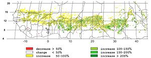
Based on Senegal river cycles, precipitation cycles of various El Sahel stations which are related to Solar(89-120 years) Wolf-Gleissberg cycles, and on relations to Nile floods and Equatorial lake levels, Yousef and Ghilly in 2000 anticipated that there is a considerable probability that drought will occur El Sahel Zone in 2005±4 years. This forecast was correct as drought occurred in El Niger in 2005 and again in 2010.
In the early 2000s, after the phenomenon of global dimming
Global dimming
Global dimming is the gradual reduction in the amount of global direct irradiance at the Earth's surface that was observed for several decades after the start of systematic measurements in the 1950s. The effect varies by location, but worldwide it has been estimated to be of the order of a 4%...
was discovered, some speculatively suggested that the drought was likely caused by air pollution generated in Eurasia and North America. The pollution changed the properties of clouds over the Atlantic ocean, disturbing the monsoon
Monsoon
Monsoon is traditionally defined as a seasonal reversing wind accompanied by corresponding changes in precipitation, but is now used to describe seasonal changes in atmospheric circulation and precipitation associated with the asymmetric heating of land and sea...
s and shifting the tropical rains southwards.
In 2005, a series of climate modeling studies performed at NOAA / Geophysical Fluid Dynamics Laboratory
Geophysical Fluid Dynamics Laboratory
The Geophysical Fluid Dynamics Laboratory is a laboratory in the National Oceanic and Atmospheric Administration /Office of Oceanic and Atmospheric Research . The current director is Dr. V...
indicated that the late 20th century Sahel drought was likely a climatic response to changing sea surface temperature patterns, and that it could be viewed as a combination of natural variability superimposed upon an anthropogenically forced regional drying trend. Using GFDL CM2.X
GFDL CM2.X
GFDL CM2.X is a coupled atmosphere-ocean general circulation model developed at the NOAA Geophysical Fluid Dynamics Laboratory in the United States...
, these climate model simulations indicated that the general late 20th century Sahel drying trend was attributable to human-induced factors; largely due to an increase in greenhouse gases and partly due to an increase in atmospheric aerosols. In IPCC future scenario A2 (CO2 value of ≈860 ppm) Sahel rainfall could be reduced by up to 25% by year 2100, according to climate models.
A 2006 study by NOAA scientists Rong Zhang and Thomas L. Delworth suggests that the Atlantic Multidecadal Oscillation
Atlantic Multidecadal Oscillation
The Atlantic multidecadal oscillation is a mode of variability occurring in the North Atlantic Ocean and which has its principal expression in the sea surface temperature field...
plays a leading role. An AMO warm phase strengthens the summer rainfall over Sahel, while a cold phase reduces it. The AMO entered a warm phase in 1995 and, assuming a 70-year cycle (following peaks in ≈1880 and ≈1950), will peak around 2020.
A 2009 study by Shanahan et al. found further evidence for a link between the AMO and West African drought.
United Nations Sahel drought response
In 1973, The United Nations Sahelian Office (UNSO) was created to address the problems of drought in the Sahel region following the West African Sahel drought of 1968-73. In the 1990s, the United Nations Convention to Combat DesertificationUnited Nations Convention to Combat Desertification
The United Nations Convention to Combat Desertification in Those Countries Experiencing Serious Drought and/or Desertification, Particularly in Africa is a Convention to combat desertification and mitigate the effects of drought through national action programs that incorporate long-term strategies...
(UNCCD) was adopted and UNSO became the United Nations Development Programme's Office to Combat Desertification and Drought, as its scope broadened to be global rather than only focused on Africa.
See also
- 2005–06 Niger food crisis
- DesertificationDesertificationDesertification is the degradation of land in drylands. Caused by a variety of factors, such as climate change and human activities, desertification is one of the most significant global environmental problems.-Definitions:...
- Yacouba SawadogoYacouba SawadogoYacouba Sawadogo is a farmer from the west African nation of Burkina Faso who has been successfully using traditional farming techniques from the region to restore soils damaged by desertification and drought.-Background:...
- Green Sahara
- 2010 Sahel famine2010 Sahel famineA large-scale, drought-induced famine occurred in Africa's Sahel region and many parts of the neighboring Sénégal River Area and Horn of Africa from February to August 2010...
- 2006 Horn of Africa food crisis2006 Horn of Africa food crisisIn 2006, an acute shortage of food affected the countries in the Horn of Africa , as well as northeastern Kenya. The United Nations's Food and Agriculture Organization estimated on January 6, 2006, that more than 11 million people in these countries may be affected by an impending widespread...
External links
- United Nations Convention to Combat Desertification home page
- Climate research summary -Sahel drought: past problems, an uncertain future Text, graphics and animations from NOAA / Geophysical Fluid Dynamics LaboratoryGeophysical Fluid Dynamics LaboratoryThe Geophysical Fluid Dynamics Laboratory is a laboratory in the National Oceanic and Atmospheric Administration /Office of Oceanic and Atmospheric Research . The current director is Dr. V...