

Aquifer
Encyclopedia
Water
Water is a chemical substance with the chemical formula H2O. A water molecule contains one oxygen and two hydrogen atoms connected by covalent bonds. Water is a liquid at ambient conditions, but it often co-exists on Earth with its solid state, ice, and gaseous state . Water also exists in a...
-bearing permeable rock or unconsolidated materials (gravel
Gravel
Gravel is composed of unconsolidated rock fragments that have a general particle size range and include size classes from granule- to boulder-sized fragments. Gravel can be sub-categorized into granule and cobble...
, sand
Sand
Sand is a naturally occurring granular material composed of finely divided rock and mineral particles.The composition of sand is highly variable, depending on the local rock sources and conditions, but the most common constituent of sand in inland continental settings and non-tropical coastal...
, or silt
Silt
Silt is granular material of a size somewhere between sand and clay whose mineral origin is quartz and feldspar. Silt may occur as a soil or as suspended sediment in a surface water body...
) from which groundwater
Groundwater
Groundwater is water located beneath the ground surface in soil pore spaces and in the fractures of rock formations. A unit of rock or an unconsolidated deposit is called an aquifer when it can yield a usable quantity of water. The depth at which soil pore spaces or fractures and voids in rock...
can be usefully extracted using a water well
Water well
A water well is an excavation or structure created in the ground by digging, driving, boring or drilling to access groundwater in underground aquifers. The well water is drawn by an electric submersible pump, a trash pump, a vertical turbine pump, a handpump or a mechanical pump...
. The study of water flow in aquifers and the characterization of aquifers is called hydrogeology
Hydrogeology
Hydrogeology is the area of geology that deals with the distribution and movement of groundwater in the soil and rocks of the Earth's crust, . The term geohydrology is often used interchangeably...
. Related terms include aquitard, which is a bed of low permeability along an aquifer, and aquiclude (or aquifuge), which is a solid, impermeable area underlying or overlying an aquifer. If the impermeable area overlies the aquifer pressure could cause it to become a confined aquifer.
Aquifer depth
Aquifers may occur at various depths. Those closer to the surface are not only more likely to be used for water supply and irrigation, but are also more likely to be topped up by the local rainfall. Many desert areas have limestone hills or mountains within them or close to them that can be exploited as groundwater resources. Parts of the Atlas MountainsAtlas Mountains
The Atlas Mountains is a mountain range across a northern stretch of Africa extending about through Morocco, Algeria, and Tunisia. The highest peak is Toubkal, with an elevation of in southwestern Morocco. The Atlas ranges separate the Mediterranean and Atlantic coastlines from the Sahara Desert...
in North Africa
North Africa
North Africa or Northern Africa is the northernmost region of the African continent, linked by the Sahara to Sub-Saharan Africa. Geopolitically, the United Nations definition of Northern Africa includes eight countries or territories; Algeria, Egypt, Libya, Morocco, South Sudan, Sudan, Tunisia, and...
, the Lebanon
Mount Lebanon
Mount Lebanon , as a geographic designation, is a Lebanese mountain range, averaging above 2,200 meters in height and receiving a substantial amount of precipitation, including snow, which averages around four meters deep. It extends across the whole country along about , parallel to the...
and Anti-Lebanon
Anti-Lebanon
The Anti-Lebanon mountains is the Western name for the Eastern Lebanon Mountain Range , which are a southwest-northeast-trending mountain range between Syria and Lebanon. Its Western name comes from the Greek word for ‘opposite’. The majority of the mountain range lies in Syria. The border between...
ranges of Syria
Syria
Syria , officially the Syrian Arab Republic , is a country in Western Asia, bordering Lebanon and the Mediterranean Sea to the West, Turkey to the north, Iraq to the east, Jordan to the south, and Israel to the southwest....
, Israel
Israel
The State of Israel is a parliamentary republic located in the Middle East, along the eastern shore of the Mediterranean Sea...
and Lebanon, the Jebel Akhdar (Oman)
Jebel Akhdar (Oman)
The Jebel Akhdar, Jabal Akhdar or Al Jabal Al Akhdar , also known as the camals hideout, is part of the Al Hajar Mountains range in Oman, which extends about 300 km northwest to southeast, between 50-100 km inland from the Gulf of Oman coast. It is one of Oman’s most spectacular areas...
in Oman
Oman
Oman , officially called the Sultanate of Oman , is an Arab state in southwest Asia on the southeast coast of the Arabian Peninsula. It is bordered by the United Arab Emirates to the northwest, Saudi Arabia to the west, and Yemen to the southwest. The coast is formed by the Arabian Sea on the...
, parts of the Sierra Nevada and neighboring ranges in the United States' Southwest
Southwestern United States
The Southwestern United States is a region defined in different ways by different sources. Broad definitions include nearly a quarter of the United States, including Arizona, California, Colorado, Nevada, New Mexico, Oklahoma, Texas and Utah...
, have shallow aquifers that are exploited for their water. Over-exploitation can lead to the exceeding of the practical sustained yield; i.e., more water is taken out than can be replenished. Along the coastlines of certain countries, such as Libya
Libya
Libya is an African country in the Maghreb region of North Africa bordered by the Mediterranean Sea to the north, Egypt to the east, Sudan to the southeast, Chad and Niger to the south, and Algeria and Tunisia to the west....
and Israel
Israel
The State of Israel is a parliamentary republic located in the Middle East, along the eastern shore of the Mediterranean Sea...
, population growth has led to over-population, which has caused the lowering of water table and the subsequent contamination of the groundwater
Groundwater
Groundwater is water located beneath the ground surface in soil pore spaces and in the fractures of rock formations. A unit of rock or an unconsolidated deposit is called an aquifer when it can yield a usable quantity of water. The depth at which soil pore spaces or fractures and voids in rock...
with saltwater from the sea
Sea
A sea generally refers to a large body of salt water, but the term is used in other contexts as well. Most commonly, it means a large expanse of saline water connected with an ocean, and is commonly used as a synonym for ocean...
(saline intrusions
Saltwater intrusion
Saltwater intrusion is the movement of saline water into freshwater aquifers. Most often, it is caused by ground-water pumping from coastal wells, or from construction of navigation channels or oil field canals. The channels and canals provide conduits for salt water to be brought into fresh...
).
The beach
Beach
A beach is a geological landform along the shoreline of an ocean, sea, lake or river. It usually consists of loose particles which are often composed of rock, such as sand, gravel, shingle, pebbles or cobblestones...
provides a model to help visualize an aquifer. If a hole is dug into the sand
Sand
Sand is a naturally occurring granular material composed of finely divided rock and mineral particles.The composition of sand is highly variable, depending on the local rock sources and conditions, but the most common constituent of sand in inland continental settings and non-tropical coastal...
, very wet or saturated sand will be located at a shallow depth. This hole is a crude well
Water well
A water well is an excavation or structure created in the ground by digging, driving, boring or drilling to access groundwater in underground aquifers. The well water is drawn by an electric submersible pump, a trash pump, a vertical turbine pump, a handpump or a mechanical pump...
, the wet sand represents an aquifer, and the level to which the water rises in this hole represents the water table
Water table
The water table is the level at which the submarine pressure is far from atmospheric pressure. It may be conveniently visualized as the 'surface' of the subsurface materials that are saturated with groundwater in a given vicinity. However, saturated conditions may extend above the water table as...
.
Classification
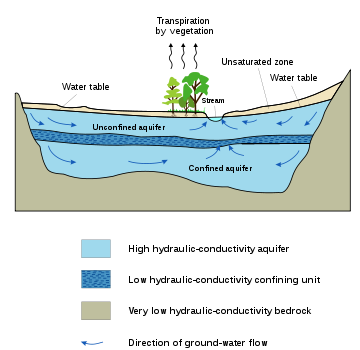
This diagram indicates typical flow directions in a cross-sectionCross section (geometry)
In geometry, a cross-section is the intersection of a figure in 2-dimensional space with a line, or of a body in 3-dimensional space with a plane, etc...
al view of a simple confined/unconfined aquifer system. The system shows two aquifers with one aquitard (a confining or impermeable layer), between them, surrounded by the bedrock aquiclude, which is in contact with a gaining stream
Stream
A stream is a body of water with a current, confined within a bed and stream banks. Depending on its locale or certain characteristics, a stream may be referred to as a branch, brook, beck, burn, creek, "crick", gill , kill, lick, rill, river, syke, bayou, rivulet, streamage, wash, run or...
(typical in humid regions). The water table
Water table
The water table is the level at which the submarine pressure is far from atmospheric pressure. It may be conveniently visualized as the 'surface' of the subsurface materials that are saturated with groundwater in a given vicinity. However, saturated conditions may extend above the water table as...
and unsaturated zone
Vadose zone
The vadose zone, also termed the unsaturated zone, is the portion of Earth between the land surface and the top of the phreatic zone i.e. the position at which the groundwater is at atmospheric pressure . Hence the vadose zone extends from the top of the ground surface to the water table...
are also illustrated.
An aquitard is a zone within the earth that restricts the flow of groundwater
Groundwater
Groundwater is water located beneath the ground surface in soil pore spaces and in the fractures of rock formations. A unit of rock or an unconsolidated deposit is called an aquifer when it can yield a usable quantity of water. The depth at which soil pore spaces or fractures and voids in rock...
from one aquifer to another. An aquitard can sometimes, if completely impermeable, be called an aquiclude or aquifuge. Aquitards are composed of layers of either clay
Clay
Clay is a general term including many combinations of one or more clay minerals with traces of metal oxides and organic matter. Geologic clay deposits are mostly composed of phyllosilicate minerals containing variable amounts of water trapped in the mineral structure.- Formation :Clay minerals...
or non-porous rock
Rock (geology)
In geology, rock or stone is a naturally occurring solid aggregate of minerals and/or mineraloids.The Earth's outer solid layer, the lithosphere, is made of rock. In general rocks are of three types, namely, igneous, sedimentary, and metamorphic...
with low hydraulic conductivity
Hydraulic conductivity
Hydraulic conductivity, symbolically represented as K, is a property of vascular plants, soil or rock, that describes the ease with which water can move through pore spaces or fractures. It depends on the intrinsic permeability of the material and on the degree of saturation...
.
Saturated versus unsaturated
GroundwaterGroundwater
Groundwater is water located beneath the ground surface in soil pore spaces and in the fractures of rock formations. A unit of rock or an unconsolidated deposit is called an aquifer when it can yield a usable quantity of water. The depth at which soil pore spaces or fractures and voids in rock...
can be found at nearly every point in the Earth's shallow subsurface, to some degree; although aquifers do not necessarily contain fresh water
Fresh Water
Fresh Water is the debut album by Australian rock and blues singer Alison McCallum, released in 1972. Rare for an Australian artist at the time, it came in a gatefold sleeve...
. The Earth's crust can be divided into two regions: the saturated
Water content
Water content or moisture content is the quantity of water contained in a material, such as soil , rock, ceramics, fruit, or wood. Water content is used in a wide range of scientific and technical areas, and is expressed as a ratio, which can range from 0 to the value of the materials' porosity at...
zone or phreatic
Phreatic
The term phreatic is used in Earth sciences to refer to matters relating to ground water below the water table . The term 'phreatic surface' indicates the location where the pore water pressure is under atmospheric conditions...
zone (e.g., aquifers, aquitards, etc.), where all available spaces are filled with water, and the unsaturated zone (also called the vadose zone
Vadose zone
The vadose zone, also termed the unsaturated zone, is the portion of Earth between the land surface and the top of the phreatic zone i.e. the position at which the groundwater is at atmospheric pressure . Hence the vadose zone extends from the top of the ground surface to the water table...
), where there are still pockets of air with some water, but can be filled with more water.
Saturated means the pressure head of the water is greater than atmospheric pressure
Atmospheric pressure
Atmospheric pressure is the force per unit area exerted into a surface by the weight of air above that surface in the atmosphere of Earth . In most circumstances atmospheric pressure is closely approximated by the hydrostatic pressure caused by the weight of air above the measurement point...
(it has a gauge pressure > 0). The definition of the water table
Water table
The water table is the level at which the submarine pressure is far from atmospheric pressure. It may be conveniently visualized as the 'surface' of the subsurface materials that are saturated with groundwater in a given vicinity. However, saturated conditions may extend above the water table as...
is surface where the pressure head
Hydraulic head
Hydraulic head or piezometric head is a specific measurement of water pressure above a geodetic datum. It is usually measured as a water surface elevation, expressed in units of length, at the entrance of a piezometer...
is equal to atmospheric pressure (where gauge pressure = 0).
Unsaturated conditions occur above the water table where the pressure head is negative (absolute pressure can never be negative, but gauge pressure can) and the water that incompletely fills the pores of the aquifer material is under suction
Suction
Suction is the flow of a fluid into a partial vacuum, or region of low pressure. The pressure gradient between this region and the ambient pressure will propel matter toward the low pressure area. Suction is popularly thought of as an attractive effect, which is incorrect since vacuums do not...
. The water content Unsaturated means the zone is held in place by surface adhesive forces
Adhesion
Adhesion is any attraction process between dissimilar molecular species that can potentially bring them in close contact. By contrast, cohesion takes place between similar molecules....
and it rises above the water table (the zero gauge pressure isobar
Isobar
Isobar may refer to:* Isobar , a line connecting points of equal atmospheric pressure* Isobar , in nuclear physics, one of multiple nuclides with equal numbers of nucleons* A heat pipe* Isobar , a 2009 science fiction film...
) by capillary action
Capillary action
Capillary action, or capilarity, is the ability of a liquid to flow against gravity where liquid spontanously rise in a narrow space such as between the hair of a paint-brush, in a thin tube, or in porous material such as paper or in some non-porous material such as liquified carbon fiber, or in a...
to saturate a small zone above the phreatic surface (the capillary fringe
Capillary fringe
The capillary fringe is the subsurface layer in which groundwater seeps up from a water table by capillary action to fill pores. Pores at the base of the capillary fringe are filled with water due to tension saturation. This saturated portion of the capillary fringe is less than total capillary...
) at less than atmospheric pressure. This is termed tension saturation and is not the same as saturation on a water content basis. Water content in a capillary fringe decreases with increasing distance from the phreatic surface. The capillary head depends on soil pore size. In sand
Sand
Sand is a naturally occurring granular material composed of finely divided rock and mineral particles.The composition of sand is highly variable, depending on the local rock sources and conditions, but the most common constituent of sand in inland continental settings and non-tropical coastal...
y soils with larger pores, the head will be less than in clay
Clay
Clay is a general term including many combinations of one or more clay minerals with traces of metal oxides and organic matter. Geologic clay deposits are mostly composed of phyllosilicate minerals containing variable amounts of water trapped in the mineral structure.- Formation :Clay minerals...
soils with very small pores. The normal capillary rise in a clayey soil is less than 1.80 m (six feet) but can range between 0.3 and 10 m (1 and 30 ft).
The capillary rise of water in a small diameter
Diameter
In geometry, a diameter of a circle is any straight line segment that passes through the center of the circle and whose endpoints are on the circle. The diameters are the longest chords of the circle...
tube is this same physical process. The water table is the level to which water will rise in a large-diameter pipe (e.g., a well) that goes down into the aquifer and is open to the atmosphere.
Aquifers versus aquitards
Aquifers are typically saturated regions of the subsurface that produce an economically feasible quantity of water to a wellWater well
A water well is an excavation or structure created in the ground by digging, driving, boring or drilling to access groundwater in underground aquifers. The well water is drawn by an electric submersible pump, a trash pump, a vertical turbine pump, a handpump or a mechanical pump...
or spring
Spring (hydrosphere)
A spring—also known as a rising or resurgence—is a component of the hydrosphere. Specifically, it is any natural situation where water flows to the surface of the earth from underground...
(e.g., sand
Sand
Sand is a naturally occurring granular material composed of finely divided rock and mineral particles.The composition of sand is highly variable, depending on the local rock sources and conditions, but the most common constituent of sand in inland continental settings and non-tropical coastal...
and gravel
Gravel
Gravel is composed of unconsolidated rock fragments that have a general particle size range and include size classes from granule- to boulder-sized fragments. Gravel can be sub-categorized into granule and cobble...
or fractured bedrock
Bedrock
In stratigraphy, bedrock is the native consolidated rock underlying the surface of a terrestrial planet, usually the Earth. Above the bedrock is usually an area of broken and weathered unconsolidated rock in the basal subsoil...
often make good aquifer materials).
An aquitard is a zone within the earth that restricts the flow of groundwater
Groundwater
Groundwater is water located beneath the ground surface in soil pore spaces and in the fractures of rock formations. A unit of rock or an unconsolidated deposit is called an aquifer when it can yield a usable quantity of water. The depth at which soil pore spaces or fractures and voids in rock...
from one aquifer to another. An aquitard can sometimes, if completely impermeable, be called an aquiclude or aquifuge. Aquitards comprise layers of either clay
Clay
Clay is a general term including many combinations of one or more clay minerals with traces of metal oxides and organic matter. Geologic clay deposits are mostly composed of phyllosilicate minerals containing variable amounts of water trapped in the mineral structure.- Formation :Clay minerals...
or non-porous rock
Rock (geology)
In geology, rock or stone is a naturally occurring solid aggregate of minerals and/or mineraloids.The Earth's outer solid layer, the lithosphere, is made of rock. In general rocks are of three types, namely, igneous, sedimentary, and metamorphic...
with low hydraulic conductivity
Hydraulic conductivity
Hydraulic conductivity, symbolically represented as K, is a property of vascular plants, soil or rock, that describes the ease with which water can move through pore spaces or fractures. It depends on the intrinsic permeability of the material and on the degree of saturation...
.
In mountainous areas (or near rivers in mountainous areas), the main aquifers are typically unconsolidated alluvium
Alluvium
Alluvium is loose, unconsolidated soil or sediments, eroded, deposited, and reshaped by water in some form in a non-marine setting. Alluvium is typically made up of a variety of materials, including fine particles of silt and clay and larger particles of sand and gravel...
, composed of mostly horizontal layers of materials deposited by water processes (rivers and streams), which in cross-section (looking at a two-dimensional slice of the aquifer) appear to be layers of alternating coarse and fine materials. Coarse materials, because of the high energy needed to move them, tend to be found nearer the source (mountain fronts or rivers), whereas the fine-grained material will make it farther from the source (to the flatter parts of the basin or overbank areas - sometimes called the pressure area). Since there are less fine-grained deposits near the source, this is a place where aquifers are often unconfined (sometimes called the forebay area), or in hydraulic communication with the land surface.
Confined versus unconfined
There are two end members in the spectrum of types of aquifers; confined and unconfined (with semi-confined being in between). Unconfined aquifers are sometimes also called water table or phreatic aquifers, because their upper boundary is the water tableWater table
The water table is the level at which the submarine pressure is far from atmospheric pressure. It may be conveniently visualized as the 'surface' of the subsurface materials that are saturated with groundwater in a given vicinity. However, saturated conditions may extend above the water table as...
or phreatic surface. (See Biscayne Aquifer
Biscayne Aquifer
The Biscayne Aquifer, named after Biscayne Bay, is a surficial aquifer. It is a shallow layer of highly permeable limestone under a portion of South Florida...
.) Typically (but not always) the shallowest aquifer at a given location is unconfined, meaning it does not have a confining layer (an aquitard or aquiclude) between it and the surface. The term "perched" refers to ground water accumulating above a low-permeability unit or strata, such as a clay layer. This term is generally used to refer to a small local area of ground water that occurs at an elevation higher than a regionally-extensive aquifer. The difference between perched and unconfined aquifers is their size (perched is smaller).
If the distinction between confined and unconfined is not clear geologically (i.e., if it is not known if a clear confining layer exists, or if the geology is more complex, e.g., a fractured bedrock aquifer), the value of storativity returned from an aquifer test
Aquifer test
An aquifer test is conducted to evaluate an aquifer by "stimulating" the aquifer through constant pumping, and observing the aquifer's "response" in observation wells...
can be used to determine it (although aquifer tests in unconfined aquifers should be interpreted differently than confined ones). Confined aquifers have very low storativity
Specific storage
Specific storage , storativity , specific yield and specific capacity are material physical properties that characterize the capacity of an aquifer to release groundwater from storage in response to a decline in hydraulic head. For that reason they are sometimes referred to as "storage properties"...
values (much less than 0.01, and as little as 10−5), which means that the aquifer is storing water using the mechanisms of aquifer matrix expansion and the compressibility of water, which typically are both quite small quantities. Unconfined aquifers have storativities (typically then called specific yield
Specific storage
Specific storage , storativity , specific yield and specific capacity are material physical properties that characterize the capacity of an aquifer to release groundwater from storage in response to a decline in hydraulic head. For that reason they are sometimes referred to as "storage properties"...
) greater than 0.01 (1% of bulk volume); they release water from storage by the mechanism of actually draining the pores of the aquifer, releasing relatively large amounts of water (up to the drainable porosity of the aquifer material, or the minimum volumetric water content
Water content
Water content or moisture content is the quantity of water contained in a material, such as soil , rock, ceramics, fruit, or wood. Water content is used in a wide range of scientific and technical areas, and is expressed as a ratio, which can range from 0 to the value of the materials' porosity at...
).
Isotropic versus anisotropic
In isotropicIsotropy
Isotropy is uniformity in all orientations; it is derived from the Greek iso and tropos . Precise definitions depend on the subject area. Exceptions, or inequalities, are frequently indicated by the prefix an, hence anisotropy. Anisotropy is also used to describe situations where properties vary...
aquifers or aquifer layers the hydraulic conductivity (K) is equal for flow in all directions, while in anisotropic
Anisotropy
Anisotropy is the property of being directionally dependent, as opposed to isotropy, which implies identical properties in all directions. It can be defined as a difference, when measured along different axes, in a material's physical or mechanical properties An example of anisotropy is the light...
conditions it differs, notably in horizontal (Kh) and vertical (Kv) sense.
Semi-confined aquifers with one or more aquitards work as an anisotropic system, even when the separate layers are isotropic, because the compound Kh and Kv values are different (see hydraulic transmissivity and hydraulic resistance).
When calculating flow to drains
Drainage equation
A drainage equation is an equation describing the relation between depth and spacing of parallel subsurface drains, depth of the watertable, depth and hydraulic conductivity of the soils. It is used in drainage design....
or flow to wells in an aquifer, the anisotropy is to be taken into account lest the resulting design of the drainage system may be faulty.
Groundwater in rock formations
GroundwaterGroundwater
Groundwater is water located beneath the ground surface in soil pore spaces and in the fractures of rock formations. A unit of rock or an unconsolidated deposit is called an aquifer when it can yield a usable quantity of water. The depth at which soil pore spaces or fractures and voids in rock...
may exist in underground rivers (e.g., cave
Cave
A cave or cavern is a natural underground space large enough for a human to enter. The term applies to natural cavities some part of which is in total darkness. The word cave also includes smaller spaces like rock shelters, sea caves, and grottos.Speleology is the science of exploration and study...
s where water flows freely underground). This may occur in eroded
Erosion
Erosion is when materials are removed from the surface and changed into something else. It only works by hydraulic actions and transport of solids in the natural environment, and leads to the deposition of these materials elsewhere...
limestone
Limestone
Limestone is a sedimentary rock composed largely of the minerals calcite and aragonite, which are different crystal forms of calcium carbonate . Many limestones are composed from skeletal fragments of marine organisms such as coral or foraminifera....
areas known as karst topography
Karst topography
Karst topography is a geologic formation shaped by the dissolution of a layer or layers of soluble bedrock, usually carbonate rock such as limestone or dolomite, but has also been documented for weathering resistant rocks like quartzite given the right conditions.Due to subterranean drainage, there...
, which make up only a small percentage of Earth's area. More usual is that the pore spaces
Porosity
Porosity or void fraction is a measure of the void spaces in a material, and is a fraction of the volume of voids over the total volume, between 0–1, or as a percentage between 0–100%...
of rocks in the subsurface are simply saturated with water — like a kitchen sponge — which can be pump
Pump
A pump is a device used to move fluids, such as liquids, gases or slurries.A pump displaces a volume by physical or mechanical action. Pumps fall into three major groups: direct lift, displacement, and gravity pumps...
ed out for agricultural, industrial, or municipal uses.
If a rock unit of low porosity
Porosity
Porosity or void fraction is a measure of the void spaces in a material, and is a fraction of the volume of voids over the total volume, between 0–1, or as a percentage between 0–100%...
is highly fractured, it can also make a good aquifer (via fissure
Fissure (disambiguation)
In anatomy, a fissure is a deep, elongated groove or tear in various parts of the body.Fissure may also refer to:* Fissure , a break in the tooth enamel* Skin fissure...
flow), provided the rock has an appreciable hydraulic conductivity
Hydraulic conductivity
Hydraulic conductivity, symbolically represented as K, is a property of vascular plants, soil or rock, that describes the ease with which water can move through pore spaces or fractures. It depends on the intrinsic permeability of the material and on the degree of saturation...
to facilitate movement of water. Porosity is important, but, alone, it does not determine a rock's ability of being an aquifer. Areas of the Deccan Traps
Deccan Traps
The Deccan Traps are a large igneous province located on the Deccan Plateau of west-central India and one of the largest volcanic features on Earth. They consist of multiple layers of solidified flood basalt that together are more than thick and cover an area of and a volume of...
(a basalt
Basalt
Basalt is a common extrusive volcanic rock. It is usually grey to black and fine-grained due to rapid cooling of lava at the surface of a planet. It may be porphyritic containing larger crystals in a fine matrix, or vesicular, or frothy scoria. Unweathered basalt is black or grey...
ic lava) in west central India
India
India , officially the Republic of India , is a country in South Asia. It is the seventh-largest country by geographical area, the second-most populous country with over 1.2 billion people, and the most populous democracy in the world...
are good examples of rock formations with high porosity but low permeability, which makes them poor aquifers. Similarly, the micro-porous (Upper Cretaceous
Cretaceous
The Cretaceous , derived from the Latin "creta" , usually abbreviated K for its German translation Kreide , is a geologic period and system from circa to million years ago. In the geologic timescale, the Cretaceous follows the Jurassic period and is followed by the Paleogene period of the...
) Chalk
Chalk
Chalk is a soft, white, porous sedimentary rock, a form of limestone composed of the mineral calcite. Calcite is calcium carbonate or CaCO3. It forms under reasonably deep marine conditions from the gradual accumulation of minute calcite plates shed from micro-organisms called coccolithophores....
of south east England, although having a reasonably high porosity, has a low grain-to-grain permeability, with much of its good water-yielding characteristics being due to micro-fracturing and fissuring.
Human dependence on groundwater
Earth
Earth is the third planet from the Sun, and the densest and fifth-largest of the eight planets in the Solar System. It is also the largest of the Solar System's four terrestrial planets...
have some form of aquifer underlying them, sometimes at significant depths.
Fresh-water aquifers, especially those with limited recharge by meteoric water
Meteoric water
Meteoric water is a hydrologic term of long standing for water in the ground which originates from precipitation. This includes water from lakes, rivers, and icemelts, which all originate from precipitation indirectly.- Overview :...
, can be over-exploited and, depending on the local hydrogeology
Hydrogeology
Hydrogeology is the area of geology that deals with the distribution and movement of groundwater in the soil and rocks of the Earth's crust, . The term geohydrology is often used interchangeably...
, may draw in non-potable water or salt
Salt
In chemistry, salts are ionic compounds that result from the neutralization reaction of an acid and a base. They are composed of cations and anions so that the product is electrically neutral...
water (saltwater intrusion
Saltwater intrusion
Saltwater intrusion is the movement of saline water into freshwater aquifers. Most often, it is caused by ground-water pumping from coastal wells, or from construction of navigation channels or oil field canals. The channels and canals provide conduits for salt water to be brought into fresh...
) from hydraulically connected aquifers or surface water bodies. This can be a serious problem, especially in coastal areas and other areas where aquifer pumping is excessive. In some areas, the ground water can be contaminated by mineral poisons, such as arsenic
Arsenic
Arsenic is a chemical element with the symbol As, atomic number 33 and relative atomic mass 74.92. Arsenic occurs in many minerals, usually in conjunction with sulfur and metals, and also as a pure elemental crystal. It was first documented by Albertus Magnus in 1250.Arsenic is a metalloid...
- see Arsenic contamination of groundwater
Arsenic contamination of groundwater
Arsenic contamination of groundwater is a natural occurring high concentration of arsenic in deeper levels of groundwater, which became a high-profile problem in recent years due to the use of deep tubewells for water supply in the Ganges Delta, causing serious arsenic poisoning to large numbers of...
.
Aquifers are critically important in human
Human
Humans are the only living species in the Homo genus...
habitation and agriculture
Agriculture
Agriculture is the cultivation of animals, plants, fungi and other life forms for food, fiber, and other products used to sustain life. Agriculture was the key implement in the rise of sedentary human civilization, whereby farming of domesticated species created food surpluses that nurtured the...
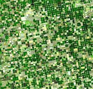
. Deep aquifers in arid areas have long been water sources for irrigation
Irrigation
Irrigation may be defined as the science of artificial application of water to the land or soil. It is used to assist in the growing of agricultural crops, maintenance of landscapes, and revegetation of disturbed soils in dry areas and during periods of inadequate rainfall...
(see Ogallala below). Many village
Village
A village is a clustered human settlement or community, larger than a hamlet with the population ranging from a few hundred to a few thousand , Though often located in rural areas, the term urban village is also applied to certain urban neighbourhoods, such as the West Village in Manhattan, New...
s and even large cities draw their water supply from wells in aquifers.
Municipal, irrigation, and industrial water supplies are provided through large wells. Multiple wells for one water supply source are termed "wellfields", which may withdraw water from confined or unconfined aquifers. Using ground water from deep, confined aquifers provides more protection from surface water contamination. Some wells, termed "collector wells," are specifically designed to induce infiltration of surface (usually river) water.
Aquifers that provide sustainable fresh groundwater to urban areas and for agricultural
Agriculture
Agriculture is the cultivation of animals, plants, fungi and other life forms for food, fiber, and other products used to sustain life. Agriculture was the key implement in the rise of sedentary human civilization, whereby farming of domesticated species created food surpluses that nurtured the...
irrigation
Irrigation
Irrigation may be defined as the science of artificial application of water to the land or soil. It is used to assist in the growing of agricultural crops, maintenance of landscapes, and revegetation of disturbed soils in dry areas and during periods of inadequate rainfall...
are typically close to the ground surface (within a couple of hundred metres) and have some recharge by fresh water. This recharge is typically from rivers or meteoric water (precipitation) that percolates into the aquifer through overlying unsaturated materials.
Aquifer depletion has been cited as one of the causes of the Great Food Crisis of 2011.
Subsidence
In unconsolidated aquifers, groundwater is produced from pore spaces between particles of gravel, sand, and silt. If the aquifer is confined by low-permeability layers, the reduced water pressure in the sand and gravel causes slow drainage of water from the adjoining confining layers. If these confining layers are composed of compressible silt or clay, the loss of water to the aquifer reduces the water pressure in the confining layer, causing it to compress from the weight of overlying geologic materials. In severe cases, this compression can be observed on the ground surface as subsidenceSubsidence
Subsidence is the motion of a surface as it shifts downward relative to a datum such as sea-level. The opposite of subsidence is uplift, which results in an increase in elevation...
. Unfortunately, much of the subsidence from groundwater extraction is permanent (elastic rebound is small). Thus, the subsidence is not only permanent, but the compressed aquifer has a permanently-reduced capacity to hold water.
Saltwater intrusion
Aquifers near the coast have a lens of freshwater near the surface and denser seawater under freshwater. Seawater penetrates the aquifer diffusing in from the ocean and is denser than freshwater. For porous (i.e., sandy) aquifers near the coast, the thickness of freshwater atop saltwater is about 40 feet (12 m) for every 1 ft (0.3048 m) of freshwater head above sea level. This relationship is called the Ghyben-Herzberg equation. If too much ground water is pumped near the coast, salt-water may intrude into freshwater aquifers causing contamination of potable freshwater supplies. Many coastal aquifers, such as the Biscayne Aquifer near Miami and the New Jersey Coastal Plain aquifer, have problems with saltwater intrusion as a result of overpumping.Salination
Aquifers in surface irrigatedIrrigation
Irrigation may be defined as the science of artificial application of water to the land or soil. It is used to assist in the growing of agricultural crops, maintenance of landscapes, and revegetation of disturbed soils in dry areas and during periods of inadequate rainfall...
areas in semi-arid zones with reuse of the unavoidable irrigation water losses percolating down into the underground by supplemental irrigation from wells run the risk of salination
Soil salination
Soil salinity is the salt content in the soil.- Causes of soil salinity :Salt-affected soils are caused by excess accumulation of salts, typically most pronounced at the soil surface. Salts can be transported to the soil surface by capillary transport from a salt laden water table and then...
.
Surface irrigation water normally contains salts in the order of 0.5 g/l or more and the annual irrigation requirement is in the order of 10000 m3/ha or more so the annual import of salt is in the order of 5000 kg/ha or more.
Under the influence of continuous evaporation, the salt concentration of the aquifer water may increase continually and eventually cause an environmental
Environmental impact of irrigation
Environmental impacts of irrigation are the changes in quantity and quality of soil and water as a result of irrigation and the ensuing effects on natural and social conditions at the tail-end and downstream of the irrigation scheme....
problem.
For salinity control in such a case, annually an amount of drainage water is to be discharged from the aquifer by means of a subsurface drainage system
Drainage system (Agriculture)
An agricultural drainage system is a system by which the water level on or in the soil is controlled to enhance agricultural crop production.-Classification:Figure 1 classifies the various types of drainage systems...
and disposed of through a safe outlet. The drainage system may be horizontal (i.e. using pipes, tile drains
Tile drainage
Tile drainage is an agriculture practice that removes excess water from soil subsurface. Whereas irrigation is the practice of adding additional water when the soil is naturally too dry, drainage brings soil moisture levels down for optimal crop growth...
or ditches) or vertical (drainage by wells). To estimate the drainage requirement, the use of a groundwater model
Groundwater model
Groundwater models are computer models of groundwater flow systems, and are used by hydrogeologists. Groundwater models are used to simulate and predict aquifer conditions.-Characteristics:...
with an agro-hydro-salinity component may be instrumental, e.g. SahysMod
SahysMod
SahysMod is a computer program for the prediction of the salinity of soil moisture, groundwater and drainage water, the depth of the watertable, and the drain discharge in irrigated agricultural lands, using different hydrogeologic and aquifer conditions, varying water management options, including...
.
Examples of aquifers
The Great Artesian BasinGreat Artesian Basin
The Great Artesian Basin provides the only reliable source of freshwater through much of inland Australia. The basin is the largest and deepest artesian basin in the world, stretching over a total of , with temperatures measured ranging from 30°C to 100°C...
situated in Australia is arguably the largest groundwater aquifer in the world (over 1.7 million km²). It plays a large part in water supplies for Queensland and remote parts of South Australia.
The Guarani Aquifer
Guaraní Aquifer
The Guarani Aquifer, l beneath the surfacntina]], Brazil, Paraguay and Uruguay, is one of the world's largest aquifer systems and is an important source of fresh water. Named after the Guarani people, it covers 1,200,000 km², with a volume of about 40,000 km³, a thickness of between 50 m and 800 m...
with an area of 1.2 million km² is shared by Brazil
Brazil
Brazil , officially the Federative Republic of Brazil , is the largest country in South America. It is the world's fifth largest country, both by geographical area and by population with over 192 million people...
, Argentina
Argentina
Argentina , officially the Argentine Republic , is the second largest country in South America by land area, after Brazil. It is constituted as a federation of 23 provinces and an autonomous city, Buenos Aires...
, Paraguay
Paraguay
Paraguay , officially the Republic of Paraguay , is a landlocked country in South America. It is bordered by Argentina to the south and southwest, Brazil to the east and northeast, and Bolivia to the northwest. Paraguay lies on both banks of the Paraguay River, which runs through the center of the...
and Uruguay
Uruguay
Uruguay ,officially the Oriental Republic of Uruguay,sometimes the Eastern Republic of Uruguay; ) is a country in the southeastern part of South America. It is home to some 3.5 million people, of whom 1.8 million live in the capital Montevideo and its metropolitan area...
.
Aquifer depletion is a problem in some areas, and is especially critical in northern Africa
Africa
Africa is the world's second largest and second most populous continent, after Asia. At about 30.2 million km² including adjacent islands, it covers 6% of the Earth's total surface area and 20.4% of the total land area...
; see the Great Manmade River
Great Manmade River
The Great Man-Made River is a network of pipes that supplies water from the Sahara Desert in Libya, from the Nubian Sandstone Aquifer System fossil aquifer. It is the world's largest irrigation project....
project of Libya
Libya
Libya is an African country in the Maghreb region of North Africa bordered by the Mediterranean Sea to the north, Egypt to the east, Sudan to the southeast, Chad and Niger to the south, and Algeria and Tunisia to the west....
for an example. However, new methods of groundwater management such as artificial recharge and injection of surface waters during seasonal wet periods has extended the life of many freshwater aquifers, especially in the United States.
The Ogallala Aquifer
Ogallala Aquifer
The Ogallala Aquifer, also known as the High Plains Aquifer, is a vast yet shallow underground water table aquifer located beneath the Great Plains in the United States...
of the central United States is one of the world's great aquifers, but in places it is being rapidly depleted
Overdrafting
Overdrafting is the process of extracting groundwater beyond the safe yield or equilibrium yield of the aquifer.Since every groundwater basin recharges at a different rate depending upon precipitation, vegetative cover and soil conservation practises, the quantity of groundwater that can be safely...
by growing municipal use, and continuing agricultural use. This huge aquifer, which underlies portions of eight states, contains primarily fossil water
Fossil water
Fossil water or paleowater is groundwater that has remained sealed in an aquifer for a long period of time. Water can rest underground in "fossil aquifers" for thousands or even millions of years...
from the time of the last glaciation
Ice age
An ice age or, more precisely, glacial age, is a generic geological period of long-term reduction in the temperature of the Earth's surface and atmosphere, resulting in the presence or expansion of continental ice sheets, polar ice sheets and alpine glaciers...
. Annual recharge, in the more arid parts of the aquifer, is estimated to total only about 10 percent of annual withdrawals.
An example of a significant and sustainable carbonate aquifer is the Edwards Aquifer
Edwards Aquifer
The Edwards Aquifer is one of the most prolific artesian aquifers in the world. Located on the eastern edge of Edwards Plateau in the U.S. state of Texas, it discharges about of water a year and directly serves about two million people...
in central Texas
Texas
Texas is the second largest U.S. state by both area and population, and the largest state by area in the contiguous United States.The name, based on the Caddo word "Tejas" meaning "friends" or "allies", was applied by the Spanish to the Caddo themselves and to the region of their settlement in...
. This carbonate aquifer has historically been providing high quality water for nearly 2 million people, and even today, is completely full because of tremendous recharge from a number of area streams, rivers and lake
Lake
A lake is a body of relatively still fresh or salt water of considerable size, localized in a basin, that is surrounded by land. Lakes are inland and not part of the ocean and therefore are distinct from lagoons, and are larger and deeper than ponds. Lakes can be contrasted with rivers or streams,...
s. The primary risk to this resource is human development over the recharge areas.
Climatic effects of aquifer depletion
Aquifer drawdownDrawdown
Drawdown has four distinct meanings:* Drawdown , a lowering of a reservoir or a change in hydraulic head in an aquifer, typically due to pumping a well.* Drawdown , decline in the value of an investment, below its all-time high....
or overdrafting
Overdrafting
Overdrafting is the process of extracting groundwater beyond the safe yield or equilibrium yield of the aquifer.Since every groundwater basin recharges at a different rate depending upon precipitation, vegetative cover and soil conservation practises, the quantity of groundwater that can be safely...
and the pumping of fossil water
Fossil water
Fossil water or paleowater is groundwater that has remained sealed in an aquifer for a long period of time. Water can rest underground in "fossil aquifers" for thousands or even millions of years...
increases the total amount of water in the hydrosphere
Hydrosphere
A hydrosphere in physical geography describes the combined mass of water found on, under, and over the surface of a planet....
that is subject to transpiration
Transpiration
Transpiration is a process similar to evaporation. It is a part of the water cycle, and it is the loss of water vapor from parts of plants , especially in leaves but also in stems, flowers and roots. Leaf surfaces are dotted with openings which are collectively called stomata, and in most plants...
and evaporation
Evaporation
Evaporation is a type of vaporization of a liquid that occurs only on the surface of a liquid. The other type of vaporization is boiling, which, instead, occurs on the entire mass of the liquid....
thereby causing accretion
Accretion (atmosphere)
Accretion is an atmospheric science term for when an ice crystal or snowflake hits a supercooled liquid droplet, which then freeze together. This increases the size of the water particle. A common example of this that is visible to people is graupel....
in water vapour and cloud cover
Cloud cover
Cloud cover refers to the fraction of the sky obscured by clouds when observed from a particular location...
which are the primary absorbers of infrared
Infrared
Infrared light is electromagnetic radiation with a wavelength longer than that of visible light, measured from the nominal edge of visible red light at 0.74 micrometres , and extending conventionally to 300 µm...
radiation in the earth's atmosphere
Atmosphere
An atmosphere is a layer of gases that may surround a material body of sufficient mass, and that is held in place by the gravity of the body. An atmosphere may be retained for a longer duration, if the gravity is high and the atmosphere's temperature is low...
. Adding water to the system has a forcing effect
Global warming
Global warming refers to the rising average temperature of Earth's atmosphere and oceans and its projected continuation. In the last 100 years, Earth's average surface temperature increased by about with about two thirds of the increase occurring over just the last three decades...
on the whole earth system
Gaia hypothesis
The Gaia hypothesis, also known as Gaia theory or Gaia principle, proposes that all organisms and their inorganic surroundings on Earth are closely integrated to form a single and self-regulating complex system, maintaining the conditions for life on the planet.The scientific investigation of the...
, an accurate estimate of which hydrogeological fact is yet to be quantified.
See also
- Hamza RiverHamza RiverHamza River is an unofficial name, for what seems to be a slowly flowing aquifer in Brazil, approximately long. Its discovery was announced in 2011...
- Aquifer storage and recoveryAquifer Storage and RecoveryAquifer storage and recovery is the re-injection of potable water back into an aquifer for later recovery and use. ASR has been done for municipal, industry and agriculture use...
- Artesian aquiferArtesian aquiferAn artesian aquifer is a confined aquifer containing groundwater under positive pressure. This causes the water level in a well to rise to a point where hydrostatic equilibrium has been reached. This type of well is called an artesian well...
- CisternCisternA cistern is a waterproof receptacle for holding liquids, usually water. Cisterns are often built to catch and store rainwater. Cisterns are distinguished from wells by their waterproof linings...
- Groundwater modelGroundwater modelGroundwater models are computer models of groundwater flow systems, and are used by hydrogeologists. Groundwater models are used to simulate and predict aquifer conditions.-Characteristics:...
- List of aquifers
- OverexploitationOverexploitationOverexploitation, also called overharvesting, refers to harvesting a renewable resource to the point of diminishing returns. Sustained overexploitation can lead to the destruction of the resource...
- Seasonal thermal storeSeasonal thermal storeA seasonal thermal store is a store designed to retain heat deposited during the hot summer months for use during colder winter weather...
- aquifers may be used as heat/cold stores for ecologically heating/cooling homes and greenhouses
External links
- Falling Water Tables
- Bibliography on Water Resources and International Law Peace Palace Library
- IGRAC International Groundwater Resources Assessment Centre
- SahysMod aquifer model