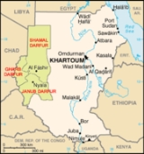
All Topics  
Darfur


   Email Print
   Bookmark   Link


Darfur


Darfur ( dar fur, lit. "realm of the Fur
Fur people

The Fur are a people of the western Sudan, principally inhabiting the region of Darfur, where they are the largest tribe.They are a Western Sudanese people who practice sedentary herding and agriculture, mainly the cultivation of millet....
") is a region in Sudan
Sudan

Sudan is a country in northeastern Africa. It is the largest in the African continent and the Arab World, and List of countries and outlying territories by total area by area....
. An independent sultan
Sultan

Sultan is an Islamic honorifics, with several historical meanings. Originally it was an Arabic language abstract noun meaning "strength", "authority", or "rulership", derived from the verbal noun ???? sulah, meaning "authority" or "power"....
ate for several hundred years, it was incorporated into Sudan by Anglo-Egyptian forces. The region is divided into three federal states: West Darfur
West Darfur

West Darfur is one of the 26 States of Sudan of Sudan, and one of three comprising the Darfur region. It has an area of 79,460 km? and an estimated population of approximately 1,007,000 ....
, South Darfur
South Darfur

South Darfur is one of the 26 States of Sudan or states of Sudan. It is one of the three states that compose the region of Darfur in western Sudan....
, and North Darfur
North Darfur

North Darfur is one of the 26 States of Sudan or states of Sudan. It is one of the states composing the Darfur region. It has an area of 296,420 km? and an estimated population of approximately 1,583,000 ....
 which are coordinated by a Transitional Darfur Regional Authority
Transitional Darfur Regional Authority

The Transitional Darfur Regional Authority is an interim authority for the Darfur region of Sudan. The TDRA was established in April 2007 under the terms of the Darfur Peace Agreement signed in May 2006....
.


Discussion
Ask a question about 'Darfur'
Start a new discussion about 'Darfur'
Answer questions from other users
Full Discussion Forum


Recent Posts


Encyclopedia


Darfur Map
Darfur ( dar fur, lit. "realm of the Fur
Fur people

The Fur are a people of the western Sudan, principally inhabiting the region of Darfur, where they are the largest tribe.They are a Western Sudanese people who practice sedentary herding and agriculture, mainly the cultivation of millet....
") is a region in Sudan
Sudan

Sudan is a country in northeastern Africa. It is the largest in the African continent and the Arab World, and List of countries and outlying territories by total area by area....
. An independent sultan
Sultan

Sultan is an Islamic honorifics, with several historical meanings. Originally it was an Arabic language abstract noun meaning "strength", "authority", or "rulership", derived from the verbal noun ???? sulah, meaning "authority" or "power"....
ate for several hundred years, it was incorporated into Sudan by Anglo-Egyptian forces. The region is divided into three federal states: West Darfur
West Darfur

West Darfur is one of the 26 States of Sudan of Sudan, and one of three comprising the Darfur region. It has an area of 79,460 km? and an estimated population of approximately 1,007,000 ....
, South Darfur
South Darfur

South Darfur is one of the 26 States of Sudan or states of Sudan. It is one of the three states that compose the region of Darfur in western Sudan....
, and North Darfur
North Darfur

North Darfur is one of the 26 States of Sudan or states of Sudan. It is one of the states composing the Darfur region. It has an area of 296,420 km? and an estimated population of approximately 1,583,000 ....
 which are coordinated by a Transitional Darfur Regional Authority
Transitional Darfur Regional Authority

The Transitional Darfur Regional Authority is an interim authority for the Darfur region of Sudan. The TDRA was established in April 2007 under the terms of the Darfur Peace Agreement signed in May 2006....
. Due to the War in Darfur, the region has been in a state of humanitarian emergency since 2003.

Climate

The rainy season is from July through September, transforming much of the region from dust brown to verdant green. As much of the population of Darfur is agricultural, the rains are vital. In normal years, pearl millet
Pearl millet

Pearl millet is the most widely grown type of millet. Grown in Africa and the Indian subcontinent since prehistoric times, it is generally accepted that pearl millet originated in Africa and was subsequently introduced into India....
, a mainstay crop is ready to be harvested by November. Once harvested, the dry stalks may be fed to domestic livestock. In the far northern desert, years may pass between rainfall. In the far south, annual average rainfall is 700 mm and many trees remain green year-round.

Geography

Darfur covers an area of some — approximately the size of France
France

France , officially the French Republic , is a country whose Metropolitan France is located in Western Europe and that also comprises various Overseas departments and territories of France....
. It is largely an arid plateau with the Marrah Mountains
Marrah Mountains

The Marrah Mountains is a range of volcanic peaks created by a massif that rises up to 3,000 m. It is located in the center of the Darfur region of Sudan, specifically within Dar Zagahawa and neighboring areas....
 (Jebel Marra), a range of volcanic peaks rising up to of topographic prominence
Topographic prominence

In topography, prominence, also known as autonomous height, relative height or shoulder drop or prime factor , is a concept used in the categorization of hills and mountains, also known as peaks....
, in the center of the region. The region's main towns are Al Fashir, Nyala
Nyala, Sudan

Nyala is the capital of South Darfur state in the western part of the Sudan. Nyala is located at elevation 2,208 feet in the Darfur historical region....
, and Geneina
Geneina

Geneina is the capital of West Darfur state in Sudan....
.

There are four main features of the physical geography. The whole eastern half of Darfur is covered with plain
Plain

In geography, a plain is an area of landscape with relatively high relief, as well as flat. Prairies and steppes are types of plains, and the archetype for a plain is often thought of as a grassland, but plains in their natural state may also be covered in shrublands, woodland and forest, or vegetation may be absent in the case of sandy or...
s and low hill
Hill

A hill is a landform that extends above the surrounding terrain, in a limited area. Hills often have a distinct Summit , although in areas with Escarpment a hill may refer to a particular section of scarp slope without a well-defined summit ....
s of sandy soils
Sand

Sand is a naturally occurring granular material composed of finely divided rock and mineral particles.As the term is used by geologists, sand particles range in diameter from 0.0625 to 2 millimeters....
, known as goz, and sandstone
Sandstone

Sandstone is a sedimentary rock composed mainly of sand-size mineral or rock Particle size . Most sandstone is composed of quartz and/or feldspar because these are the most common minerals in the Earth's crust ....
 hills. In many places the goz is waterless and can only be inhabited where there are water reservoirs or deep borehole
Borehole

A borehole is the generalised term for any narrow Shaft mining drilled in the ground, either vertically or horizontally. A borehole may be constructed for many different purposes including the extraction of water or other liquid or gases , as part of a geotechnical investigation or Phase I Environmental Site Assessment#Other types of ESA, fo...
s. While dry, goz may also support rich pasture and arable land
Arable land

In geography, arable land is an agriculture term, meaning land that can be used for growing agriculture. Arable land is currently being lost at the rate of over 200,000 km? per year....
. To the north the goz is overtaken by the desert sands of the Sahara
Sahara

The Sahara is the world's largest hot desert. At over 9,000,000 square kilometers , it covers most of Northern Africa, making it almost as large as the United States or the continent of Europe....
. A second feature are the wadi
Wadi

Wadi is the Arabic term traditionally referring to a valley; in some cases it may refer to a dry Stream bed that contains water only during times of heavy rain....
s
, which range from seasonal watercourses that flood only occasionally during the wet season to large wadis that flood
Flood

A flood is an overflow of an expanse of water that submerges land, a deluge. In the sense of "flowing water", the word may also be applied to the inflow of the tide....
 for most of the rains and flow from western Darfur hundreds of miles west to Lake Chad
Lake Chad

Lake Chad is a historically large, shallow lake in Africa, whose size has varied greatly over the centuries. It is economically very important, providing water to more than 20 million people living in the four countries which surround it — Chad, Cameroon, Niger and Nigeria....
. Many wadis have pans of alluvium
Alluvium

Alluvium is soil or sediments deposited by a river or other running water. Alluvium is typically made up of a variety of materials, including fine particles of silt and clay and larger particles of sand and gravel....
 with rich soil that are also difficult to cultivate. Western Darfur is dominated by the third feature, basement rock
Basement rock

Basement rock usually refers to the thick foundation of ancient, and oldest metamorphic and igneous rock that forms the Crust of continents, often in the form of granite....
, sometimes covered with a thin layer of sandy soil. Basement rock is too infertile to be farmed, but provides sporadic forest cover that can be grazed by animals. The fourth and final feature are the Marrah Mountains
Marrah Mountains

The Marrah Mountains is a range of volcanic peaks created by a massif that rises up to 3,000 m. It is located in the center of the Darfur region of Sudan, specifically within Dar Zagahawa and neighboring areas....
, volcanic plugs created by a massif
Massif

In geology, a massif is a section of a planet's Crust that is demarcated by geologic faults or flexures. In the Plate tectonics, a massif tends to retain its internal structure while being displaced as a whole....
, that rise up to a peak at Deriba crater
Deriba Crater

File:Deriba Caldera.jpgDeriba Crater is at the highest point of Jebel Marra at an elevation of 3,042 m , in Darfur in the western part of Sudan. It is between 5km and 8km in diameter across the outer crater....
 where there is a small area of temperate climate, high rainfall and permanent springs of water.

Remote sensing
Remote sensing

Remote sensing is the small or large-scale acquisition of information of an object or phenomenon, by the use of either recording or real-time sensing device that is not in physical or intimate contact with the object ....
 has detected the imprint of a vast underground lake under Darfur. The potential water deposits are estimated at . The lake, during epochs when the region was more humid, would have contained about 607 cubic miles of water. It may have dried up thousands of years ago.

History

Bandera Darfur
Darfur is conjectured to have been part of the Urheimat
Urheimat

Urheimat is a Linguistics term denoting the original homeland of the speakers of a proto-language....
 of the Proto-Afro-Asiatic
Proto-Afro-Asiatic

Proto-Afro-Asiatic is the hypothetical proto-language from which modern Afro-Asiatic languages are descended.Ilya Yabonovich and other linguists, in examining the differences between the various members of the Afro-Asiatic family have realised that all of the old etymologies for this group were inherently semitocentric....
 language in distant prehistoric times (c. 10,000 BC), though there are numerous other theories that exclude Darfur.

Most of the region is a semi-arid plain and thus insufficient for supporting a large and complex civilization. While the Marrah Mountains offer plentiful water, the Daju people
Daju

The Daju culture stems from the Daju empire in the Darfur region of western Sudan.The Daju, formerly inhabitants of Jebel Marra now live in and around Nyala, Fasha and Dara, appear to have been the dominant group in Darfur in the earliest period recorded....
 created the first known Darfurian civilization based in the mountains, though they left no records beside a list of kings. The Tunjur
Tunjur

The Tunjur, or Tungur, are a Muslim people estimated around 176.000 people, living in central Darfur, a province of Sudan. They are mainly farmers, and closely associated with the Fur people, even if differently from these they have been fully Arabic language....
 displaced the Daju in the fourteenth century and introduced Islam
Islam

Islam is a Monotheism, Abrahamic religion originating with the teachings of the Prophets of Islam Muhammad, a 7th century Arab religious and political figure....
. The Tunjur sultan
Sultan

Sultan is an Islamic honorifics, with several historical meanings. Originally it was an Arabic language abstract noun meaning "strength", "authority", or "rulership", derived from the verbal noun ???? sulah, meaning "authority" or "power"....
s intermarried with the Fur
Fur people

The Fur are a people of the western Sudan, principally inhabiting the region of Darfur, where they are the largest tribe.They are a Western Sudanese people who practice sedentary herding and agriculture, mainly the cultivation of millet....
 and sultan M. Solaiman (reigned c.1596 to c.1637) is considered the founder of the Keira dynasty
Keira dynasty

The Keira dynasty were the rulers of the Sultanate of Darfur from the seventeenth century to 1916. Originally the Keira clan were perhaps regional rulers in the Tunjur state, with Sulayman Solong traditionally seen as the founder of the Darfur state....
. Darfur became a great power of the Sahel
Sahel

File:Sahel Map-Africa rough.pngFile:AT0713 map.pngThe Sahel or Sahel Belt is a semi-arid tropical and subtropical grasslands, savannas, and shrublands ecoregion in Africa, which forms the transition between the Sahara to the north and the slightly less arid savanna belt to the south, known as the Sudan ....
 under the Keira dynasty, expanding its borders as far east as the Atbarah River
Atbarah River

The Atbarah River in northeast Africa rises in northwest Ethiopia, approximately 50 km north of Lake Tana and 30 km west of Gondar. It flows about 805 km to the Nile in north-central Sudan, joining it at the city of Atbarah ....
 and attracting immigrants from Bornu
Bornu Empire

The Bornu Empire was a medieval African state of Nigeria from 1389 to 1893. It was a continuation of the great Kanem Empire founded centuries earlier by the Sayfawa Dynasty....
 and Bagirmi. During the mid-18th century the country was wracked by conflict between rival factions, and external war with Sennar and Wadai
Ouaddai Kingdom

The Ouaddai Empire was originally a non-Islam kingdom, located to the east of Lake Chad in present-day Chad. It emerged in the sixteenth century as an offshoot of the state of Darfur to the northeast of the kingdom of Baguirmi....
. In 1875, the weakened kingdom was destroyed by the Egyptian ruler set up in Khartoum, largely through the machinations of Sebehr Rahma, a businessman who was competing with the dar
DAR

DAR can refer to:An organization:* Daughters of the American Revolution* DAR Aircraft, a Bulgarian aircraft manufacturer* , German Accreditation Council...
 over access to slaves and ivory
Ivory

File:Ivory decoration.jpgIvory is formed from dentine and constitutes the bulk of the teeth and tusks of animals such as the elephant, hippopotamus, walrus, mammoth and narwhal....
 in Bahr el Ghazal
Bahr el Ghazal

The Bahr el Ghazal is a region of southwestern Sudan. Its name comes from the river Bahr el Ghazal .The region consists of the States of Sudan of North Bahr al Ghazal, West Bahr al Ghazal, Lakes, Sudan, and Warab ....
 to the south of Darfur.

Darfur Idps 1 Camp
The Darfurians were restive under Egyptian rule, but were no more predisposed to accept the rule of the self proclaimed Mahdi
Mahdi

According to the Shia and Sunni versions of the Islamic eschatology the Mahdi is the prophesied redeemer of Islam who will stay on earth seven, nine, or nineteen years before the coming of the day, Qiyamah ....
, Muhammad Ahmad
Muhammad Ahmad

Muhammad Ahmad ibn as Sayyid Abd Allah was a religious leader, in Sudan, who proclaimed himself the Mahdi in 1881, and declared a jihad against Egyptian authority in Sudan....
, when his forces defeated the British forces (that had just invaded Egypt in 1882) in Darfur in 1883. When Ahmad's successor, Abdallahi ibn Muhammad
Abdallahi ibn Muhammad

Abdullah Ibn-Mohammed or Abdullah al-Taaisha, also known as "The Khalifa" was a Sudanese Ansar General and ruler.Abdullah was born into the Baqqara tribe in Darfur in 1846 and was trained and educated as a preacher and holy man....
, himself a Darfuri, demanded that the pastoralist tribes provide soldiers, several tribes rose up in revolt. Following the overthrow of Abdallahi at Omdurman
Omdurman

Omdurman is the Demographics of Sudan in Sudan and Khartoum State, lying on the western banks of the river Nile, opposite the capital, Khartoum....
 in 1899 by the Anglo-Egyptian forces, the new Anglo-Egyptian government recognized Ali Dinar as the sultan of Darfur and largely left the dar to its own affairs except for a nominal annual tribute. During World War I
World War I

World War I, or the First World War , was a global military conflict which involved the Great powers, organized into two opposing military alliances: the Allies of World War I and the Central Powers....
, the British became concerned that the sultanate might fall under the influence of Ottoman Empire
Ottoman Empire

The Ottoman Empire , also known by its contemporaries as the Turkish Empire or Turkey , was an empire that lasted from 1299?1923. It was Treaty of Lausanne by the Republic of Turkey, which was officially proclaimed on October 29, 1923....
, invaded and incorporated Darfur into the Anglo-Egyptian Sudan in 1916. Under colonial rule, financial and administrative resources were directed to the tribes of central Sudan near Khartoum to the detriment of the outlying regions such as Darfur.

This pattern of skewed development continued following national independence in 1956. To this was added an element of political instability caused by the proxy wars between Sudan, Libya
Libya

Libya , officially the Great Socialist People's Libyan Arab Jamahiriya , is a country located in North Africa. Bordering the Mediterranean Sea to the north, Libya lies between Egypt to the east, Sudan to the southeast, Chad and Niger to the south, and Algeria and Tunisia to the west....
 and Chad
Chad

Chad , officially known as the Republic of Chad, is a landlocked country in central Africa. It is bordered by Libya to the north, Sudan to the east, the Central African Republic to the south, Cameroon and Nigeria to the southwest, and Niger to the west....
. The influence of an ideology of Arab supremacy propagated by Libyan leader Muammar al-Gaddafi
Muammar al-Gaddafi

Muammar Abu Minyar al-Gaddafi#Name also known as Colonel Gaddafi has been the de facto leader of Libya since a 1969 coup....
 that began to be acted upon by Darfurians, including those identified as "Arab" and "African". A famine
Famine

A famine is a widespread shortage of food that may apply to any faunal species, which phenomenon is usually accompanied by regional malnutrition, starvation, epidemic, and increased death....
 in the mid-1980s disrupted many societal structures and led to the first significant fighting amongst Darfuris. A low level conflict continued for the next 15 years, with the government coopting and arming "Arab" militias against its enemies. The fighting reached a peak in 2003 with the beginning of the Darfur conflict
Darfur conflict

The War in Darfur is a conflict that is in the Darfur region of western Sudan. Unlike the Second Sudanese Civil War, the current lines of conflict are seen by some reporters to be ethnic and tribal, rather than religious....
, in which the resistance coalesced into a roughly cohesive rebel movement. The conflict soon came to be regarded as one of the worst humanitarian disasters in the world. Over 2.5 million people have been displaced since the beginning of the conflict. Many of these refugees have gone into camps where emergency aid has created conditions that, although extremely basic, are better than in the villages, which offer no protection against the various militias that operate in the region.

Government

The region is divided into three federal states: West Darfur
West Darfur

West Darfur is one of the 26 States of Sudan of Sudan, and one of three comprising the Darfur region. It has an area of 79,460 km? and an estimated population of approximately 1,007,000 ....
, South Darfur
South Darfur

South Darfur is one of the 26 States of Sudan or states of Sudan. It is one of the three states that compose the region of Darfur in western Sudan....
, and North Darfur
North Darfur

North Darfur is one of the 26 States of Sudan or states of Sudan. It is one of the states composing the Darfur region. It has an area of 296,420 km? and an estimated population of approximately 1,583,000 ....
. The Darfur Agreement established a Transitional Darfur Regional Authority
Transitional Darfur Regional Authority

The Transitional Darfur Regional Authority is an interim authority for the Darfur region of Sudan. The TDRA was established in April 2007 under the terms of the Darfur Peace Agreement signed in May 2006....
 (TDRA) as an interim authority for the region. The agreement states that a referendum on autonomy for Darfur should be held no later than 2011. Minni Minnawi is the current Chairperson of the TDRA.

See also

  • War in Darfur