
.gif)
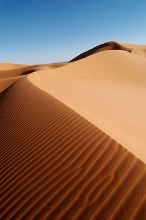
Erg (landform)
Encyclopedia

Desert
A desert is a landscape or region that receives an extremely low amount of precipitation, less than enough to support growth of most plants. Most deserts have an average annual precipitation of less than...
covered with wind
Wind
Wind is the flow of gases on a large scale. On Earth, wind consists of the bulk movement of air. In outer space, solar wind is the movement of gases or charged particles from the sun through space, while planetary wind is the outgassing of light chemical elements from a planet's atmosphere into space...
-swept sand
Sand
Sand is a naturally occurring granular material composed of finely divided rock and mineral particles.The composition of sand is highly variable, depending on the local rock sources and conditions, but the most common constituent of sand in inland continental settings and non-tropical coastal...
with little or no vegetative cover. The term takes its name from the Arabic
Arabic language
Arabic is a name applied to the descendants of the Classical Arabic language of the 6th century AD, used most prominently in the Quran, the Islamic Holy Book...
word ʿarq , meaning "dune field". Strictly speaking, an erg is defined as a desert area that contains more than 125 square kilometres (48.3 sq mi) of aeolian or wind-blown sand and where sand covers more than 20% of the surface. Smaller areas are known as "dune fields". The largest hot desert in the world, the Sahara
Sahara
The Sahara is the world's second largest desert, after Antarctica. At over , it covers most of Northern Africa, making it almost as large as Europe or the United States. The Sahara stretches from the Red Sea, including parts of the Mediterranean coasts, to the outskirts of the Atlantic Ocean...
, covers 9 million km2s (3,474,919.4 sq mi) and contains several ergs, such as the Chech Erg (24.57°N 2.59°W) and the Issaouane Erg
Issaouane Erg
The Issaouane Erg is an approximately 38,000 km2 erg in Algeria's portion of the Sahara desert. It is located at . -Topography:...
(31.18°N 7.93°W) in Algeria
Algeria
Algeria , officially the People's Democratic Republic of Algeria , also formally referred to as the Democratic and Popular Republic of Algeria, is a country in the Maghreb region of Northwest Africa with Algiers as its capital.In terms of land area, it is the largest country in Africa and the Arab...
. Approximately 85% of all the Earth's mobile sand is found in ergs that are greater than 32000 square kilometres (12,355.3 sq mi). Ergs are also found on other celestial bodies, such as Venus
Venus
Venus is the second planet from the Sun, orbiting it every 224.7 Earth days. The planet is named after Venus, the Roman goddess of love and beauty. After the Moon, it is the brightest natural object in the night sky, reaching an apparent magnitude of −4.6, bright enough to cast shadows...
, Mars
Mars
Mars is the fourth planet from the Sun in the Solar System. The planet is named after the Roman god of war, Mars. It is often described as the "Red Planet", as the iron oxide prevalent on its surface gives it a reddish appearance...
, and Saturn
Saturn
Saturn is the sixth planet from the Sun and the second largest planet in the Solar System, after Jupiter. Saturn is named after the Roman god Saturn, equated to the Greek Cronus , the Babylonian Ninurta and the Hindu Shani. Saturn's astronomical symbol represents the Roman god's sickle.Saturn,...
's moon Titan
Titan (moon)
Titan , or Saturn VI, is the largest moon of Saturn, the only natural satellite known to have a dense atmosphere, and the only object other than Earth for which clear evidence of stable bodies of surface liquid has been found....
.
Description
20th parallel north
The 20th parallel north is a circle of latitude that is 20 degrees north of the Earth's equatorial plane. It crosses Africa, Asia, the Indian Ocean, the Pacific Ocean, North America, the Caribbean and the Atlantic Ocean....
to 40°N
40th parallel north
The 40th parallel north is a circle of latitude that is 40 degrees north of the Earth's equatorial plane. It crosses Europe, the Mediterranean Sea, Asia, the Pacific Ocean, North America, and the Atlantic Ocean....
and 20°
20th parallel south
The 20th parallel south is a circle of latitude that is 20 degrees south of the Earth's equatorial plane. It crosses the Atlantic Ocean, Africa, the Indian Ocean, Australasia, the Pacific Ocean and South America....
to 40°S
40th parallel south
The 40th parallel south is a circle of latitude that is 40 degrees south of the Earth's equatorial plane. It crosses the Atlantic Ocean, the Indian Ocean, Australasia, the Pacific Ocean and South America....
latitudes, which include regions crossed by the dry, subsiding air of the trade wind
Trade wind
The trade winds are the prevailing pattern of easterly surface winds found in the tropics, within the lower portion of the Earth's atmosphere, in the lower section of the troposphere near the Earth's equator...
s. Active ergs are limited to regions that receive, on the average, no more than 150 mm of annual precipitation. The largest are in northern
North Africa
North Africa or Northern Africa is the northernmost region of the African continent, linked by the Sahara to Sub-Saharan Africa. Geopolitically, the United Nations definition of Northern Africa includes eight countries or territories; Algeria, Egypt, Libya, Morocco, South Sudan, Sudan, Tunisia, and...
and southern
Southern Africa
Southern Africa is the southernmost region of the African continent, variably defined by geography or geopolitics. Within the region are numerous territories, including the Republic of South Africa ; nowadays, the simpler term South Africa is generally reserved for the country in English.-UN...
Africa
Africa
Africa is the world's second largest and second most populous continent, after Asia. At about 30.2 million km² including adjacent islands, it covers 6% of the Earth's total surface area and 20.4% of the total land area...
, central
Central Asia
Central Asia is a core region of the Asian continent from the Caspian Sea in the west, China in the east, Afghanistan in the south, and Russia in the north...
and western
Southwest Asia
Western Asia, West Asia, Southwest Asia or Southwestern Asia are terms that describe the westernmost portion of Asia. The terms are partly coterminous with the Middle East, which describes a geographical position in relation to Western Europe rather than its location within Asia...
Asia
Asia
Asia is the world's largest and most populous continent, located primarily in the eastern and northern hemispheres. It covers 8.7% of the Earth's total surface area and with approximately 3.879 billion people, it hosts 60% of the world's current human population...
, and Central Australia
Central Australia
Central Australia/Alice Springs Region is one of the five regions in the Northern Territory. The term Central Australia is used to describe an area centred on Alice Springs in Australia. It is sometimes referred to as Centralia; likewise the people of the area are sometimes called Centralians...
. In South America
South America
South America is a continent situated in the Western Hemisphere, mostly in the Southern Hemisphere, with a relatively small portion in the Northern Hemisphere. The continent is also considered a subcontinent of the Americas. It is bordered on the west by the Pacific Ocean and on the north and east...
, ergs are limited by the Andes Mountains
Andes
The Andes is the world's longest continental mountain range. It is a continual range of highlands along the western coast of South America. This range is about long, about to wide , and of an average height of about .Along its length, the Andes is split into several ranges, which are separated...
, but they do contain extremely large dunes in coastal Peru
Peru
Peru , officially the Republic of Peru , is a country in western South America. It is bordered on the north by Ecuador and Colombia, on the east by Brazil, on the southeast by Bolivia, on the south by Chile, and on the west by the Pacific Ocean....
and northwestern Argentina
Argentina
Argentina , officially the Argentine Republic , is the second largest country in South America by land area, after Brazil. It is constituted as a federation of 23 provinces and an autonomous city, Buenos Aires...
. They are also found in several parts of the northeast coast of Brazil
Brazil
Brazil , officially the Federative Republic of Brazil , is the largest country in South America. It is the world's fifth largest country, both by geographical area and by population with over 192 million people...
. The only active erg in North America
North America
North America is a continent wholly within the Northern Hemisphere and almost wholly within the Western Hemisphere. It is also considered a northern subcontinent of the Americas...
is in the Gran Desierto de Altar
Gran Desierto de Altar
The Gran Desierto de Altar is one of the major portions of the Sonoran Desert of Mexico, including the only active erg dune region in North America. It extends across much of the northern border of the Gulf of California, reaching more than 100 kilometers east to west, and over 50 km north to...
(31.95°N 114.14°W) that extends from the Sonoran Desert
Sonoran Desert
The Sonoran Desert is a North American desert which straddles part of the United States-Mexico border and covers large parts of the U.S. states of Arizona and California and the northwest Mexican states of Sonora, Baja California, and Baja California Sur. It is one of the largest and hottest...
in the northwestern Mexican state of Sonora
Sonora
Sonora officially Estado Libre y Soberano de Sonora is one of the 31 states which, with the Federal District, comprise the 32 Federal Entities of Mexico. It is divided into 72 municipalities; the capital city is Hermosillo....
to the Yuma Desert
Yuma Desert
The Yuma Desert is a lower-elevation section of the Sonoran Desert in the southwestern United States and the northwest of Mexico. It is in the Salton basin. The desert contains areas of sparse vegetation and has notable areas of sand dunes. With an average rainfall less than 8 inches each...
of Arizona
Arizona
Arizona ; is a state located in the southwestern region of the United States. It is also part of the western United States and the mountain west. The capital and largest city is Phoenix...
and the Algodones Dunes
Algodones Dunes
The Algodones Dunes is a large erg located in the southeastern portion of the U.S. state of California, near the border with Arizona and the Mexican state of Baja California. The field is approximately 45 miles long by 6 miles wide and extends along a northwest-southeast line that correlates to...
of southeastern California
California
California is a state located on the West Coast of the United States. It is by far the most populous U.S. state, and the third-largest by land area...
. An erg that has been fixed by vegetation forms the Nebraska Sand Hills (42.13°N 102.19°W).
Riverbed
Riverbed may refer to:*Stream bed, the channel bottom of a stream or river or creek*Wadi, a dry riverbed that contains water only during times of heavy rain*Riverbed Technology, an American technology company...
s and deltas
River delta
A delta is a landform that is formed at the mouth of a river where that river flows into an ocean, sea, estuary, lake, reservoir, flat arid area, or another river. Deltas are formed from the deposition of the sediment carried by the river as the flow leaves the mouth of the river...
, floodplain
Floodplain
A floodplain, or flood plain, is a flat or nearly flat land adjacent a stream or river that stretches from the banks of its channel to the base of the enclosing valley walls and experiences flooding during periods of high discharge...
s, glacial outwash plains
Sandur
A sandur is a glacial outwash plain formed of sediments deposited by meltwater at the terminus of a glacier.- Formation :Sandar are found in glaciated areas, such as Svalbard, Kerguelen Islands, and Iceland...
, dry lake
Lake
A lake is a body of relatively still fresh or salt water of considerable size, localized in a basin, that is surrounded by land. Lakes are inland and not part of the ocean and therefore are distinct from lagoons, and are larger and deeper than ponds. Lakes can be contrasted with rivers or streams,...
s, and beach
Beach
A beach is a geological landform along the shoreline of an ocean, sea, lake or river. It usually consists of loose particles which are often composed of rock, such as sand, gravel, shingle, pebbles or cobblestones...
es. Almost all major ergs are located downwind from river beds in areas that are too dry to support extensive vegetative cover and are thus subject to long-continued wind erosion. Sand from these abundant sources migrates downwind and builds up into very large dunes where its movement is halted or slowed by topographic barriers to windflow or by convergence of windflow. Entire ergs and dune fields tend to migrate downwind as far as hundreds of kilometers from their sources of sand. Such accumulation requires long periods of time. At least one million years are required to build ergs with very large dunes, such as those on the Arabian Peninsula
Arabian Peninsula
The Arabian Peninsula is a land mass situated north-east of Africa. Also known as Arabia or the Arabian subcontinent, it is the world's largest peninsula and covers 3,237,500 km2...
, in North Africa, and in central Asia. Sand seas that have accumulated in subsiding structural and topographic basins, such as the Murzuk Sand Sea (25.90°N 13.90°W) of Libya
Libya
Libya is an African country in the Maghreb region of North Africa bordered by the Mediterranean Sea to the north, Egypt to the east, Sudan to the southeast, Chad and Niger to the south, and Algeria and Tunisia to the west....
, may attain great thicknesses (more than 1000 m) but others, such as the ergs of linear dunes in the Simpson Desert
Simpson Desert
The Simpson Desert is a large area of dry, red sandy plain and dunes in Northern Territory, South Australia and Queensland in central Australia. It is the fourth largest Australian desert, with an area of 176,500 km² ....
(24.95°N 137.42°W) and Great Sandy Desert
Great Sandy Desert
The Great Sandy Desert is a desert located in the North West of Western Australia straddling the Pilbara and southern Kimberley regions. It is the second largest desert in Australia after the Great Victoria Desert and encompasses an area of...
(19.70°N 122.62°W) of Australia, may be no thicker than the individual dunes superposed on the alluvial plain
Alluvial plain
An alluvial plain is a relatively flat landform created by the deposition of sediment over a long period of time by one or more rivers coming from highland regions, from which alluvial soil forms...
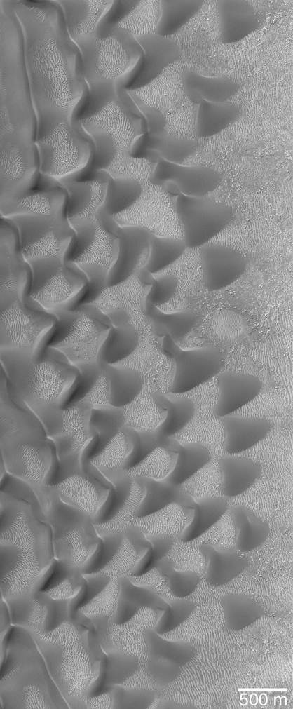
. Within sand seas in a given area, the dunes tend to be of a single type. For example, there are ergs or fields of linear dunes, of crescentic dunes, of star dunes, and of parabolic dunes, and these dune arrays tend to have consistent orientations and sizes.
By nature, ergs are very active. Smaller dunes form and migrate along the flanks of the larger dunes and sand ridges. Occasional precipitation
Precipitation (meteorology)
In meteorology, precipitation In meteorology, precipitation In meteorology, precipitation (also known as one of the classes of hydrometeors, which are atmospheric water phenomena is any product of the condensation of atmospheric water vapor that falls under gravity. The main forms of precipitation...
fills basins formed by the dunes; as the water evaporates, salt
Salt
In chemistry, salts are ionic compounds that result from the neutralization reaction of an acid and a base. They are composed of cations and anions so that the product is electrically neutral...
deposits are left behind.
Individual dunes in ergs typically have widths, lengths, or both dimensions greater than 500 m (1,640.4 ft). Both the regional extent of their sand cover and the complexity and great size of their dunes distinguish ergs from dune fields. The depth of sand in ergs varies widely around the world, ranging from only a few centimeters deep in the Selima Sand Sheet of Southern Egypt, to approximately 1 m (3.3 ft) in the Simpson Desert, and 21 – in the Sahara. This is far shallower than ergs in prehistoric times were. Evidence in the geological record indicates that some Mesozoic
Mesozoic
The Mesozoic era is an interval of geological time from about 250 million years ago to about 65 million years ago. It is often referred to as the age of reptiles because reptiles, namely dinosaurs, were the dominant terrestrial and marine vertebrates of the time...
and Paleozoic
Paleozoic
The Paleozoic era is the earliest of three geologic eras of the Phanerozoic eon, spanning from roughly...
ergs reached a mean depth of several hundred meters.
Extraterrestrial ergs
Ergs are a geological feature that can be found on planet
Planet
A planet is a celestial body orbiting a star or stellar remnant that is massive enough to be rounded by its own gravity, is not massive enough to cause thermonuclear fusion, and has cleared its neighbouring region of planetesimals.The term planet is ancient, with ties to history, science,...
s where an atmosphere
Atmosphere
An atmosphere is a layer of gases that may surround a material body of sufficient mass, and that is held in place by the gravity of the body. An atmosphere may be retained for a longer duration, if the gravity is high and the atmosphere's temperature is low...
capable of significant wind erosion acts on the surface for a significant period of time, creating sand
Sand
Sand is a naturally occurring granular material composed of finely divided rock and mineral particles.The composition of sand is highly variable, depending on the local rock sources and conditions, but the most common constituent of sand in inland continental settings and non-tropical coastal...
and allowing it to accumulate.
Today at least three bodies, apart from Earth, are known in the solar system
Solar System
The Solar System consists of the Sun and the astronomical objects gravitationally bound in orbit around it, all of which formed from the collapse of a giant molecular cloud approximately 4.6 billion years ago. The vast majority of the system's mass is in the Sun...
to feature ergs on their surface: Venus, Mars and Titan.
Venus
At least two ergs have been recognized by the Magellan probeMagellan probe
The Magellan spacecraft, also referred to as the Venus Radar Mapper, was a 1,035-kilogram robotic space probe launched by NASA on May 4, 1989, to map the surface of Venus using Synthetic Aperture Radar and measure the planetary gravity...
on Venus
Venus
Venus is the second planet from the Sun, orbiting it every 224.7 Earth days. The planet is named after Venus, the Roman goddess of love and beauty. After the Moon, it is the brightest natural object in the night sky, reaching an apparent magnitude of −4.6, bright enough to cast shadows...
: the Aglaonice dune field, which covers approximately 1290 square kilometre, and the Meshkenet dune field (~17120 square kilometre). These seem to be mostly transverse dune fields (with dune crests perpendicular to prevailing winds).
Mars
MarsMars
Mars is the fourth planet from the Sun in the Solar System. The planet is named after the Roman god of war, Mars. It is often described as the "Red Planet", as the iron oxide prevalent on its surface gives it a reddish appearance...
shows very large ergs, especially next to the polar caps, where dunes can reach a considerable size. Ergs on Mars can exhibit strange shapes and patterns, due to complex interaction with the underlying surface and wind direction.
Titan
Radar images captured by the CassiniCassini-Huygens
Cassini–Huygens is a joint NASA/ESA/ASI spacecraft mission studying the planet Saturn and its many natural satellites since 2004. Launched in 1997 after nearly two decades of gestation, it includes a Saturn orbiter and an atmospheric probe/lander for the moon Titan, although it has also returned...
spacecraft as it flew by Titan
Titan (moon)
Titan , or Saturn VI, is the largest moon of Saturn, the only natural satellite known to have a dense atmosphere, and the only object other than Earth for which clear evidence of stable bodies of surface liquid has been found....
in October 2005 show sand dunes at Titan's equator much like those in deserts of Earth. One erg was observed to be more than 930 miles (1,497 km) long. Dunes are a dominant landform on Titan. Approximately 15-20% of the surface is covered by ergs with an estimated total area of 12–18 million km2 making it the largest dune field coverage in the solar system identified to date.
The sand dunes are believed to be formed by wind generated as a result of tidal forces from Saturn on Titan's atmosphere. The images are evidence that these dunes were built from winds that blow in one direction before switching to another and then back to the first direction and so on, causing the sand dunes to build up in long parallel lines. These tidal winds combined with Titan's west-to-east zonal winds create dunes aligned west-to-east nearly everywhere except close to mountains, which alter wind direction.
The sand on Titan might have formed when liquid methane rained and eroded the ice bedrock, possibly in the form of flash floods. Alternatively, the sand could also have come from organic solids produced by photochemical reactions in Titan's atmosphere.
See also
- Aeolian processes
- Blowout (geology)Blowout (geology)Blowouts are sandy depressions in a sand dune ecosystem caused by the removal of sediments by wind.Blowouts occur in partially vegetated dunefields or sandhills. A blowout forms when a patch of protective vegetation is lost, allowing strong winds to "blow out" sand and form a depression...
- Desert pavementDesert pavementA desert pavement is a desert surface that is covered with closely packed, interlocking angular or rounded rock fragments of pebble and cobble size.-Formation:Several theories have been proposed for their formation...
- HamadaHamadaA hamada is a type of desert landscape consisting of largely barren, hard, rocky plateaus, with very little sand. A hamada may sometimes also be called a reg , though this more properly refers to a stony plain rather than a highland.Hamadas exist in contrast to ergs, which are large areas of...
- List of ergs
- Médanos (geology)
- YardangYardangA yardang is a streamlined hill carved from bedrock or any consolidated or semiconsolidated material by the dual action of wind abrasion, dust and sand, and deflation. Yardangs become elongated features typically three or more times longer than wide, and when viewed from above, resemble the hull of...