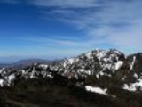
All Topics  
Atlas Mountains

 
Atlas Mountains

   Email Print
   Bookmark   Link


Atlas Mountains


The Atlas Mountains (Kabyle
Kabyle language

Kabyle is a Berber language spoken by the Kabyle people. In 1995, there were 7,123,000 speakers worldwide, the majority in Algeria, where there were more than 4,500,000....
: Idurar n le?les) are a mountain range
Mountain range

A mountain range is a chain of mountains bordered by highlands or separated from other mountains by mountain pass or valleys. Individual mountains within the same mountain range do not necessarily have the same geology, though they often do; they may be a mix of different orogeny, for example volcanoes, uplifted mountains or Fold mountains...
 across a northern stretch of Africa
Africa

Africa is the world's second-largest and second most-populous continent, after Asia. At about 30.2 million km? including adjacent islands, it covers 6% of the Earth's total surface area and 20.4% of the total land area....
 extending about 2,400 km (1,500 miles) through Morocco
Morocco

Morocco , officially the Kingdom of Morocco , is a country located in North Africa with a population of nearly 34 million and an area just under 447,000 km2....
, Algeria
Algeria

Algeria , officially the People's Democratic Republic of Algeria, is a country located in North Africa. It is the largest country of the Mediterranean sea, second largest in the Arab World, and the second largest on the African continent and the eleventh-largest country in the world in terms of land area....
, and Tunisia
Tunisia

Tunisia , officially the Tunisian Republic , is a country located in North Africa. It is bordered by Algeria to the west and Libya to the southeast....
. The highest peak is Jbel Toubkal
Jbel Toubkal

Jbel Toubkal / Adrar n Toubkal is a mountain peak in southwestern Morocco, located in the Toubkal National Park. At 4,167 metres, it is the highest peak in the Atlas Mountains and in North Africa....
, with an elevation of in southwestern Morocco. The second highest mountain is the M'Goun
M'Goun

The M'Goun mountain, also rendered as Ighil Mgoun, Ighil n?Oumsoud, Irhil M?Goun, Ighil M?Goun, Jebel Mgoun, Djebel Ighil M?Goun and Djebel A?t M?goun, at 4,071 metres is the second highest peak of the Atlas Mountains....
 of . The Atlas ranges separate the Mediterranean
Mediterranean Sea

The Mediterranean Sea is a sea or Ocean off the Atlantic Ocean surrounded by the Mediterranean region and almost completely enclosed by land: on the north by Europe, on the south by Africa, and on the east by Asia....
 and Atlantic
Atlantic Ocean

The Atlantic Ocean is the second-largest of the world's oceanic divisions; with a total area of about 106.4 million square kilometres . It covers approximately one-fifth of the Earth's surface....
 coastlines from the Sahara
Sahara

The Sahara is the world's largest hot desert. At over 9,000,000 square kilometers , it covers most of Northern Africa, making it almost as large as the United States or the continent of Europe....
 Desert. The population of the Atlas Mountains are mainly Berber tribes
Berber people

Berbers are the indigenous ethnic groups of North Africa west of the Nile Valley. They are discontinuously distributed from the Atlantic to the Siwa oasis, in Egypt, and from the Mediterranean to the Niger River....
 in Morocco and kabyles in Algeria
Algeria

Algeria , officially the People's Democratic Republic of Algeria, is a country located in North Africa. It is the largest country of the Mediterranean sea, second largest in the Arab World, and the second largest on the African continent and the eleventh-largest country in the world in terms of land area....
.


Discussion
Ask a question about 'Atlas Mountains'
Start a new discussion about 'Atlas Mountains'
Answer questions from other users
Full Discussion Forum


Encyclopedia


The Atlas Mountains (Kabyle
Kabyle language

Kabyle is a Berber language spoken by the Kabyle people. In 1995, there were 7,123,000 speakers worldwide, the majority in Algeria, where there were more than 4,500,000....
: Idurar n le?les) are a mountain range
Mountain range

A mountain range is a chain of mountains bordered by highlands or separated from other mountains by mountain pass or valleys. Individual mountains within the same mountain range do not necessarily have the same geology, though they often do; they may be a mix of different orogeny, for example volcanoes, uplifted mountains or Fold mountains...
 across a northern stretch of Africa
Africa

Africa is the world's second-largest and second most-populous continent, after Asia. At about 30.2 million km? including adjacent islands, it covers 6% of the Earth's total surface area and 20.4% of the total land area....
 extending about 2,400 km (1,500 miles) through Morocco
Morocco

Morocco , officially the Kingdom of Morocco , is a country located in North Africa with a population of nearly 34 million and an area just under 447,000 km2....
, Algeria
Algeria

Algeria , officially the People's Democratic Republic of Algeria, is a country located in North Africa. It is the largest country of the Mediterranean sea, second largest in the Arab World, and the second largest on the African continent and the eleventh-largest country in the world in terms of land area....
, and Tunisia
Tunisia

Tunisia , officially the Tunisian Republic , is a country located in North Africa. It is bordered by Algeria to the west and Libya to the southeast....
. The highest peak is Jbel Toubkal
Jbel Toubkal

Jbel Toubkal / Adrar n Toubkal is a mountain peak in southwestern Morocco, located in the Toubkal National Park. At 4,167 metres, it is the highest peak in the Atlas Mountains and in North Africa....
, with an elevation of in southwestern Morocco. The second highest mountain is the M'Goun
M'Goun

The M'Goun mountain, also rendered as Ighil Mgoun, Ighil n?Oumsoud, Irhil M?Goun, Ighil M?Goun, Jebel Mgoun, Djebel Ighil M?Goun and Djebel A?t M?goun, at 4,071 metres is the second highest peak of the Atlas Mountains....
 of . The Atlas ranges separate the Mediterranean
Mediterranean Sea

The Mediterranean Sea is a sea or Ocean off the Atlantic Ocean surrounded by the Mediterranean region and almost completely enclosed by land: on the north by Europe, on the south by Africa, and on the east by Asia....
 and Atlantic
Atlantic Ocean

The Atlantic Ocean is the second-largest of the world's oceanic divisions; with a total area of about 106.4 million square kilometres . It covers approximately one-fifth of the Earth's surface....
 coastlines from the Sahara
Sahara

The Sahara is the world's largest hot desert. At over 9,000,000 square kilometers , it covers most of Northern Africa, making it almost as large as the United States or the continent of Europe....
 Desert. The population of the Atlas Mountains are mainly Berber tribes
Berber people

Berbers are the indigenous ethnic groups of North Africa west of the Nile Valley. They are discontinuously distributed from the Atlantic to the Siwa oasis, in Egypt, and from the Mediterranean to the Niger River....
 in Morocco and kabyles in Algeria
Algeria

Algeria , officially the People's Democratic Republic of Algeria, is a country located in North Africa. It is the largest country of the Mediterranean sea, second largest in the Arab World, and the second largest on the African continent and the eleventh-largest country in the world in terms of land area....
. The terms for 'mountain' in some Berber languages are adrar and adras, believed to be cognate with the toponym.

The mountains are divided into additional and separate ranges, including the Middle Atlas
Middle Atlas

The Middle Atlas is part of the Atlas Mountains lying in Morocco, a mountainous country with more than 100,000 km? or 22% of the surface rising above 2,000 meters....
, High Atlas
High Atlas

High Atlas, also called the Grand Atlas Mountains is a mountain range in central Morocco in Northern Africa.The High Atlas rises in the west at the Atlantic Ocean and stretches in an eastern direction to the Moroccan-Algerian border....
, and Anti-Atlas
Anti-Atlas

The Anti-Atlas or Jebel Saghru, or Lesser Atlas, is one of the mountain ranges lying in Morocco, as part of the Atlas mountains in the northwest of Africa....
. The lower Tell Atlas
Tell Atlas

The Tell Atlas is a mountain chain over 1,500 kilometers in length, belonging to the Atlas Mountains ranges in North Africa, stretching from Morocco, through Algeria to Tunisia....
 running near the coast and the larger Saharan Atlas
Saharan Atlas

The Saharan Atlas of Algeria is the eastern portion of the Atlas Mountains. Not as tall as the Grand Atlas of Morocco they are far more imposing than the Tell Atlas range that runs closer to the coast....
 running further south terminate in the Aurès Mountains
Aurès Mountains

The Aur?s refers to an Amazigh language-speaking region in East Algeria, as well as an extension of the Atlas Mountains that lies to the east of the Saharan Atlas in eastern Algeria and northwestern Tunisia....
 located in Algeria and Tunisia
Tunisia

Tunisia , officially the Tunisian Republic , is a country located in North Africa. It is bordered by Algeria to the west and Libya to the southeast....
. The Atlas Mountains constitute one of the distinct physiographic provinces of the larger African Alpine System division.

Geology

Atlas Mountains Labeled 2
The basement rock
Basement rock

Basement rock usually refers to the thick foundation of ancient, and oldest metamorphic and igneous rock that forms the Crust of continents, often in the form of granite....
 of most of Africa was formed in the Precambrian
Precambrian

The Precambrian is an informal name for the supereon comprising the eon of the geologic timescale that came before the current Phanerozoic eon....
 (approximately 4.5 billion years ago) and is much older than the Atlas mountains lying in Africa. The Atlas formed during three subsequent phases of Earth's history.

The first tectonic deformation phase involves only the Anti-Atlas
Anti-Atlas

The Anti-Atlas or Jebel Saghru, or Lesser Atlas, is one of the mountain ranges lying in Morocco, as part of the Atlas mountains in the northwest of Africa....
, which was formed in the Paleozoic
Paleozoic

The Paleozoic or Palaeozoic Era is the earliest of three geology Era of the Phanerozoic Eon . The Paleozoic spanned from roughly , and is subdivided into six period ; from oldest to youngest they are: the Cambrian, Ordovician, Silurian, Devonian period, Carboniferous, and Permian...
 Era (~300 million years ago) as the result of continental collision
Collision

A collision is an isolated event in which two or more bodies exert relatively strong forces on each other for a relatively short time....
s. North America
North America

North America is the northern continent of the Americas, situated in the Earth's northern hemisphere and almost totally in the western hemisphere....
, Europe
Europe

Europe is, conventionally, one of the world's seven continents. Comprising the westernmost peninsula of Eurasia, Europe is generally divided from Asia to its east by the water divide of the Ural Mountains, the Ural , the Caspian Sea, and by the Caucasus Mountains to the southeast....
 and Africa
Africa

Africa is the world's second-largest and second most-populous continent, after Asia. At about 30.2 million km? including adjacent islands, it covers 6% of the Earth's total surface area and 20.4% of the total land area....
 were connected millions of years ago.
Atlas Mountains Tectonic Plates
The Anti-Atlas mountains are believed to have originally been formed as part of Alleghenian orogeny
Alleghenian orogeny

The Alleghenian orogeny or Appalachian orogeny is one of the geology mountain-forming events that formed the Appalachian Mountains and Allegheny Mountains....
. These mountains were formed when Africa and America collided, and were once a chain rivaling today's Himalayas
Himalayas

The Himalaya Range or Himalayas for short , meaning "abode of snow" ), is a mountain range in Asia, separating the Indian subcontinent from the Tibetan Plateau....
. Today, the remains of this chain can be seen in the Fall line
Fall line

In geomorphology, a fall line marks the area where an upland region and a coastal plain meet. Technically, a fall line is an unconformity. A fall line is typically prominent when crossed by a river, for there will often be rapids or waterfalls....
 in the eastern United States
United States

The United States of America is a Federal government constitutional republic comprising U.S. state and a federal district. The country is situated mostly in central North America, where its Contiguous United States and Washington, D.C., the Capital districts and territories, lie between the Pacific Ocean and Atlantic Oceans, Borders of the U...
. Some remnants can also be found in the later formed Appalachians
Appalachian Mountains

The Appalachian Mountains or , often called the Appalachians, are a vast mountain range in eastern North America. Definitions vary on the precise boundaries of the Appalachians....
 in North America.

A second phase took place during the Mesozoic
Mesozoic

The Mesozoic Era is one of three Geologic time scale of the Phanerozoic eon . The division of time into eras dates back to Giovanni Arduino, in the 18th century, although his original name for the era now called the 'Mesozoic' was 'Secondary' ....
 Era (before ~65 My) and consisted of a widespread extension of the Earth's crust
Crust (geology)

In geology, a crust is the outermost solid shell of a planet or moon, which is chemically distinct from the underlying mantle . Crusts of Earth , our Moon, Mercury , Venus, and Mars have been generated largely by igneous processes, and these crusts are richer in incompatible elements than their respective mantle s....
 that rift
Rift

In geology, a rift is a place where the Earth's Crust and lithosphere are being pulled apart and is an example of extensional tectonics.Typical rift features are a central linear downdropped geologic fault segment, called a graben, with parallel normal faulting and rift-flank uplifts on either side forming a rift valley, where the rift r...
ed and separated the continents mentioned above. This extension was responsible for the formation of many thick intracontinental sedimentary basin
Sedimentary basin

The term sedimentary basin is used to refer to any geographical feature exhibiting subsidence and consequent infilling by sedimentation. As the sediments are buried, they are subjected to increasing pressure and begin the process of lithification....
s including the present Atlas. Most of the rocks forming the surface of the present High Atlas were deposited under the ocean at that time.

Finally, in the Tertiary
Tertiary

The Tertiary is a a term for a Geologic time scale#Terminology 65 million to 1.8 million years ago. The Tertiary covered the time span between the superseded Secondary period and an out-of-date definition of the Neogene#Controversy....
 Era (~65 million to ~1.8 million years ago), the mountain chains that today comprise the Atlas were uplifted as the land masses of Europe and Africa collided at the southern end of the Iberian peninsula
Iberian Peninsula

The Iberian Peninsula, or Iberia, is located in the extreme southwest of Europe and includes modern-day Spain, Portugal, Andorra and Gibraltar and a very small area of France....
. Such convergent tectonic boundaries
Plate tectonics

Plate tectonics describes the large scale motions of Earth's lithosphere. The theory encompasses the older concepts of continental drift, developed during the first decades of the 20th century by Alfred Wegener, and seafloor spreading, understood during the 1960s....
 occur where two plates slide towards each other forming a subduction
Subduction

In geology, subduction is the process that takes place at convergent boundary by which one tectonic plate moves under another tectonic plate, sinking into the Earth's mantle, as the plates converge....
 zone (if one plate moves underneath the other) and/or a continental collision
Orogeny

Orogeny refers to natural mountain building, and may be studied as a tectonic structural event, as a geographical event, and a chronological event: orogenic events cause distinctive structural phenomena and related tectonic activity, affect certain regions of rocks and crust, and happen within a specific period of time....
 (when the two plates contain continental crust
Continental crust

The continental crust is the layer of igneous, sedimentary, and metamorphic rocks which form the continents and the areas of shallow seabed close to their shores, known as Continental shelf....
). In the case of the Africa-Europe collision, it is clear that tectonic convergence is partially responsible for the formation of the High Atlas
High Atlas

High Atlas, also called the Grand Atlas Mountains is a mountain range in central Morocco in Northern Africa.The High Atlas rises in the west at the Atlantic Ocean and stretches in an eastern direction to the Moroccan-Algerian border....
, as well as for the closure of the Strait of Gibraltar
Strait of Gibraltar

The Strait of Gibraltar is the strait that connects the Atlantic Ocean to the Mediterranean Sea and separates Spain from Morocco. The name comes from Gibraltar, which in turn originates from the Arabic language Jebel Tariq meaning mountain of Tariq....
 and the formation of the Alps
Alps

The Alps is the name for one of the great mountain range systems of Europe, stretching from Austria and Slovenia in the east; through Italy, Switzerland, Liechtenstein and Germany; to France in the west....
 and the Pyrenees
Pyrenees

The Pyrenees are a mountain range in southwest Europe that form a natural border between France and Spain. They separate the Iberian Peninsula from the rest of continental Europe, and extend for about from the Bay of Biscay to the Mediterranean Sea ....
. However, there is a lack of evidence for the nature of the subduction in the Atlas region, or for the thickening of the Earth's crust generally associated with continental collisions. In fact, one of the most striking features of the Atlas to geologists is the relative small amount of crustal thickening and tectonic shortening despite the important altitude of the mountain range. Recent studies suggest that deep processes rooted in the Earth's mantle may have contributed to the uplift of the High and Middle Atlas.

Natural resources

The Atlas are rich in natural resources
Natural Resources

Natural Resources is a soul album released by Motown girl group Martha Reeves and the Vandellas in 1970 on the Gordy label. The album is significant for the Vietnam War ballad "I Should Be Proud" and the slow jam, "Love Guess Who"....
. There are deposits of iron ore
Iron ore

Iron ores are Rock and minerals from which metallic iron can be economically extracted. The ores are usually rich in iron oxides and vary in colour from dark grey, bright yellow, deep purple, to rusty red....
, lead ore, copper
Copper

Copper is a chemical element with the symbol Cu and atomic number 29.It is a ductile metal with very high thermal and electrical conductivity....
, silver
Silver

Silver is a chemical element with the chemical symbol Ag and atomic number 47. A soft, white, lustrous transition metal, it has the highest electrical conductivity of any element and the highest thermal conductivity of any metal....
, mercury
Mercury (element)

Mercury , also called quicksilver or hydrargyrum , is a chemical element with the symbol Hg and atomic number 80. A heavy, silvery d-block metal, mercury is one of six elements that are liquid at or near room temperature and pressure....
, rock salt, phosphate
Phosphate

A phosphate, an inorganic chemical, is a Salt of phosphoric acid. Inorganic phosphates are mining to obtain phosphorus for use in agriculture and industry....
, marble
Marble

Marble is a nonfoliated metamorphic rock resulting from the metamorphism of limestone, composed mostly of calcite . It is extensively used for Marble sculpture, as a architecture material, and in many other applications....
, anthracite coal
Anthracite coal

Anthracite is a hard, compact variety of mineral coal that has a high lustre . It has the highest carbon count and contains the fewest impurities of all coals, despite its lower Heating value content....
, and natural gas
Natural gas

Natural gas is a gas consisting primarily of methane. It is found associated with fossil fuels, in coal beds, as methane clathrates, and is created by methanogenic organisms in marshes, bogs, and landfills....
 among other resources.

Subranges of the Atlas Mountains

The range can be divided into three general regions from west to east:
  • Middle Atlas, High Atlas, and Anti-Atlas (Morocco).
  • Saharan Atlas
    Saharan Atlas

    The Saharan Atlas of Algeria is the eastern portion of the Atlas Mountains. Not as tall as the Grand Atlas of Morocco they are far more imposing than the Tell Atlas range that runs closer to the coast....
     (Algeria).
  • Tell Atlas
    Tell Atlas

    The Tell Atlas is a mountain chain over 1,500 kilometers in length, belonging to the Atlas Mountains ranges in North Africa, stretching from Morocco, through Algeria to Tunisia....
     (Algeria, Tunisia).


Middle Atlas range

The Middle Atlas is a portion of the Atlas mountain range lying completely in Morocco. The Middle Atlas is the westernmost of three Atlas Mountains chains that define a large plateaued basin extending eastward into Algeria
Algeria

Algeria , officially the People's Democratic Republic of Algeria, is a country located in North Africa. It is the largest country of the Mediterranean sea, second largest in the Arab World, and the second largest on the African continent and the eleventh-largest country in the world in terms of land area....
. South of the Middle Atlas and separated by the Moulouya
Moulouya River

Moulouya River is a 520 km long river in Morocco. Its sources are located in Middle Atlas. It empties to the Mediterranean Sea west of Algeria at about . Water level in the river often fluctuates. The river is being used for irrigation....
 and Oum Er-Rbia
Oum Er-Rbia River

Oum Er-Rbia , is a river in central Morocco. The river is 555 km long and is the longest in the country. With an average water debit of 105 m3/s, Oum Er-Rbia is the second largest river in Morocco after the Sebou River....
 rivers, the High Atlas
High Atlas

High Atlas, also called the Grand Atlas Mountains is a mountain range in central Morocco in Northern Africa.The High Atlas rises in the west at the Atlantic Ocean and stretches in an eastern direction to the Moroccan-Algerian border....
 stretches for with a succession of peaks among which ten reach above . North of the Middle Atlas and separated by the Sebou River
Sebou River

Sebou is a river in northern Morocco. The river is 458 km long and has an average water flow of 137 m3/s. The Sebou is the largest by volume and the second longest river in the country ....
, the Rif
Rif

The Rif is a mainly mountainous region of northern Morocco, stretching from Cape Spartel and Tangier in the west to Ras Kebdana and the Moulouya River in the east, and from the Mediterranean Sea in the north to the river of Ouargha in the south....
 mountains are an extension of the Baetic Cordillera
Baetic Cordillera

The Baetic Cordillera is a mountain system in the southern and eastern Spain. Also known as the Baetic ranges or Baetic mountains, and in Spanish language as the Sistema Penib?tico, the Baetic Cordillera is made up of multiple mountain ranges that reach from western Andalusia to Murcia and Valencia , trending generally...
 (Baetic mountains, which include the Sierra Nevada
Sierra Nevada (Spain)

File:Nevadawikipedia.jpgThe Sierra Nevada, meaning "snowy range" in Spanish language, is a mountain range in the region of Andalusia in Spain....
) in the south of Spain.

High Atlas
Main article: High Atlas
High Atlas

High Atlas, also called the Grand Atlas Mountains is a mountain range in central Morocco in Northern Africa.The High Atlas rises in the west at the Atlantic Ocean and stretches in an eastern direction to the Moroccan-Algerian border....


The High Atlas in central Morocco rises in the west at the Atlantic coast
Atlantic Ocean

The Atlantic Ocean is the second-largest of the world's oceanic divisions; with a total area of about 106.4 million square kilometres . It covers approximately one-fifth of the Earth's surface....
 and stretches in an eastern direction to the Moroccan-Algerian border. At the Atlantic and to the southwest the range drops abruptly and makes an impressive transition to the coast and the Anti-Atlas range. To the north, in the direction of Marrakech
Marrakech

Marrakesh or Marrakech , known as the "Red City", is an important city/Wiktionary:medina in Morocco. It has a population of 1,036,500 , and is the capital of the mid-southwestern economic region of Marrakech-Tensift-Al Haouz , near the foothills of the snow-capped Atlas Mountains....
, the range descends less abruptly.

On the heights of Ouarzazate
Ouarzazate

Ouarzazate , is a city in southern Morocco.Its name comes from a Berber languages phrase meaning "without noise" or "without confusion". It is also featured by its closeness to Atlas Mountains and Draa River Valley....
 the massif is cut through by the Draa valley which opens southward. In this chaos of rocks the contrasts are astonishing: water runs in some places, forming clear basins. It is mainly inhabited by Berber people, who live in small villages and cultivate the high plains of Ourika Valley.

Lake of Barrage Couvagnac Panoramic
Near Barrage Cavagnac, there is a hydroelectric dam
Dam

A dam is a barrier that Reservoirs surface water or underground streams. Dams generally serve the primary purpose of retaining water, while other structures such as floodgates, levees, and Dike are used to manage or prevent water flow into specific land regions....
 that has created the artificial lake Lalla Takerkoust. The lake serves also as a source for fish for the local fishermen.

The largest villages and towns of the area are Tahanaoute, Amizmiz
Amizmiz

Amizmiz is a small town in Morocco approximately 55 kilometers south of Marrakech. It lies at the foot of the High Atlas mountain range.Its population of approximately 11,000 consists mainly of Berbers of Chleuh origin who speak the Tashelhiyt language dialect....
, Asni
Asni

Asni is a small town in the foothills of the High Atlas near Marrakech, Morocco.External links*...
, Tin Mal
Tin Mal

Tin Mal is a small mountain village in the High Atlas at 100 km of Marrakech, Morocco. It is considered the cradle of the Almohad empire from where they started their military campaigns against the Almoravids in early 12th century....
, Ijoukak, and Oukaïmden.

Anti-Atlas ranges

The Anti-Atlas extends from the Atlantic Ocean
Atlantic Ocean

The Atlantic Ocean is the second-largest of the world's oceanic divisions; with a total area of about 106.4 million square kilometres . It covers approximately one-fifth of the Earth's surface....
 in the southwest of Morocco toward the northeast to the heights of Ouarzazate
Ouarzazate

Ouarzazate , is a city in southern Morocco.Its name comes from a Berber languages phrase meaning "without noise" or "without confusion". It is also featured by its closeness to Atlas Mountains and Draa River Valley....
 and further east to the city of Tafilalt
Tafilalt

Tafilalt or Tafilet is a region and the most important oasis of the Morocco Sahara; it is also considered one of the largest oasis in the world, the oasis is entirely located along the Ziz River....
 (altogether a distance of approximately ). In the south it borders the Sahara
Sahara

The Sahara is the world's largest hot desert. At over 9,000,000 square kilometers , it covers most of Northern Africa, making it almost as large as the United States or the continent of Europe....
. The easternmost point of the anti-Atlas is the Djebel Sarhro mountains and its eastern boundary is set by sections of the High Atlas range
High Atlas

High Atlas, also called the Grand Atlas Mountains is a mountain range in central Morocco in Northern Africa.The High Atlas rises in the west at the Atlantic Ocean and stretches in an eastern direction to the Moroccan-Algerian border....
.

Saharan Atlas range


The Saharan Atlas of Algeria
Algeria

Algeria , officially the People's Democratic Republic of Algeria, is a country located in North Africa. It is the largest country of the Mediterranean sea, second largest in the Arab World, and the second largest on the African continent and the eleventh-largest country in the world in terms of land area....
 is the eastern portion of the Atlas mountain range. Not as high as the Grand Atlas they are far more imposing than the Tell Atlas range that runs to the north of them and closer to the coast. The tallest peak in the range is the high Djebel Aissa. They mark the northern edge of the Sahara Desert. The mountains see some rainfall and are better suited to agriculture than the plateau
Plateau

In geology and earth science, a plateau, also called a high plateau or tableland, is an area of highland , usually consisting of relatively flat terrain....
 region to the north. Today most of the population of the region are Berbers
Berber people

Berbers are the indigenous ethnic groups of North Africa west of the Nile Valley. They are discontinuously distributed from the Atlantic to the Siwa oasis, in Egypt, and from the Mediterranean to the Niger River....
.

Tell Atlas range

Panoramic View of Typical Berber Village (morocco   High Atlas Mountains)
The Tell Atlas is a mountain chain over in length, belonging to the Atlas mountain ranges and stretching from Morocco, through Algeria to Tunisia. It parallels the Mediterranean coast. Together with the Saharan Atlas to the south it forms the northernmost of two more or less parallel ranges which gradually approach one another towards the east, merging in Eastern Algeria. At the western ends at the Middle Atlas
Middle Atlas

The Middle Atlas is part of the Atlas Mountains lying in Morocco, a mountainous country with more than 100,000 km? or 22% of the surface rising above 2,000 meters....
 range in Morocco. The area immediately to the south of this range is high plateau, with lakes in the wet season and salt flats in the dry.

Aurès mountain range


The Aurès Mountains of Algeria and Tunisia
Tunisia

Tunisia , officially the Tunisian Republic , is a country located in North Africa. It is bordered by Algeria to the west and Libya to the southeast....
 are the furthest eastern portion of the Atlas mountain range.

See also

  • Capsian culture
    Capsian culture

    The Capsian culture was a Mesolithic culture of the Maghreb, which lasted from about 10,000 to 6,000 BCE. It was concentrated mainly in modern Algeria, and Tunisia, with some sites attested in Cyrenaica ....
  • North Africa
    North Africa

    North Africa or Northern Africa is the northernmost region of the African continent, separated by the Sahara from Sub-Saharan Africa.Geopolitically, the United Nations subregion of Northern Africa includes the following seven countries or territories:...