

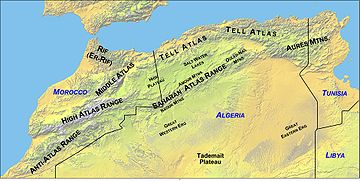
Saharan Atlas
Encyclopedia
Algeria
Algeria , officially the People's Democratic Republic of Algeria , also formally referred to as the Democratic and Popular Republic of Algeria, is a country in the Maghreb region of Northwest Africa with Algiers as its capital.In terms of land area, it is the largest country in Africa and the Arab...
is the eastern portion of the Atlas Mountains
Atlas Mountains
The Atlas Mountains is a mountain range across a northern stretch of Africa extending about through Morocco, Algeria, and Tunisia. The highest peak is Toubkal, with an elevation of in southwestern Morocco. The Atlas ranges separate the Mediterranean and Atlantic coastlines from the Sahara Desert...
. Not as tall as the Grand Atlas of Morocco
Morocco
Morocco , officially the Kingdom of Morocco , is a country located in North Africa. It has a population of more than 32 million and an area of 710,850 km², and also primarily administers the disputed region of the Western Sahara...
they are far more imposing than the Tell Atlas
Tell Atlas
The Tell Atlas is a mountain chain over 1,500 kilometers in length, belonging to the Atlas mountain ranges in North Africa, stretching from Morocco, through Algeria to Tunisia. It parallels the Mediterranean coast...
range that runs closer to the coast. The tallest peak in the range is the 2236 m (7,336 ft) high Djebel Aissa.
The Saharan Atlas includes a series of shorter ranges: the Amour, Ksour and Ouled-Naïl Mountains. The Tell Atlas and the Saharan Atlas merge in the east to join together into the Tébessa and Medjerda mountains.
The Saharan Atlas is one of the vast plateaus of Africa
Africa
Africa is the world's second largest and second most populous continent, after Asia. At about 30.2 million km² including adjacent islands, it covers 6% of the Earth's total surface area and 20.4% of the total land area...
, formed of ancient base rock covered by the sediment of shallow seas and alluvial deposits.
Among the rivers of the Atlas, the Saharan Atlas feeds wadi
Wadi
Wadi is the Arabic term traditionally referring to a valley. In some cases, it may refer to a dry riverbed that contains water only during times of heavy rain or simply an intermittent stream.-Variant names:...
s. Among these are the Chelif and Touil
Touil
Touil is a town and commune in Mauritania....
wadis, riverbeds that contains water only during wet periods, respectively draining the Amour and Ouled-Naïl ranges of the Saharan Atlas.
The Saharan Atlas Mountains mark the northern edge of the Sahara Desert. The mountains see some rainfall and are better suited to agriculture than the plateau
Plateau
In geology and earth science, a plateau , also called a high plain or tableland, is an area of highland, usually consisting of relatively flat terrain. A highly eroded plateau is called a dissected plateau...
region to the north. Today most of the population of the region are Chaoui
Chaoui
The Shawia people, or Chaouis are a Berber people who live mainly in the Aurès, Nememcha and Belezma Region in the Aurès Mountains, a large part of eastern Algeria known in ancient times as Numidia...
Berbers
Berber people
Berbers are the indigenous peoples of North Africa west of the Nile Valley. They are continuously distributed from the Atlantic to the Siwa oasis, in Egypt, and from the Mediterranean to the Niger River. Historically they spoke the Berber language or varieties of it, which together form a branch...
. The mountains have also long been home to exiles expelled from the fertile coastal regions.
The Sahara desert is one of the largest in the world.