
Sea level
Encyclopedia
Aviation
Aviation is the design, development, production, operation, and use of aircraft, especially heavier-than-air aircraft. Aviation is derived from avis, the Latin word for bird.-History:...
, where standard sea level pressure is used as the measurement datum of altitude at flight level
Flight level
A Flight Level is a standard nominal altitude of an aircraft, in hundreds of feet. This altitude is calculated from the International standard pressure datum of 1013.25 hPa , the average sea-level pressure, and therefore is not necessarily the same as the aircraft's true altitude either...
s.
Measurement

Tide gauge
A tide gauge is a device for measuring sea level and detecting tsunamis.Sensors continuously record the height of the water level with respect to a height reference surface close to the geoid...
, MSL means the "still water level"—the level of the sea with motions such as wind wave
Wave
In physics, a wave is a disturbance that travels through space and time, accompanied by the transfer of energy.Waves travel and the wave motion transfers energy from one point to another, often with no permanent displacement of the particles of the medium—that is, with little or no associated mass...
s averaged out—averaged over a period of time such that changes in sea level, e.g., due to the tide
Tide
Tides are the rise and fall of sea levels caused by the combined effects of the gravitational forces exerted by the moon and the sun and the rotation of the Earth....
s, also get averaged out. One measures the values of MSL in respect to the land. Hence a change in MSL can result from a real change in sea level, or from a change in the height of the land on which the tide gauge operates.
In the UK, mean sea level has been measured at Newlyn
Newlyn
Newlyn is a town and fishing port in southwest Cornwall, England, United Kingdom.Newlyn forms a conurbation with the neighbouring town of Penzance and is part of Penzance civil parish...
in Cornwall
Cornwall
Cornwall is a unitary authority and ceremonial county of England, within the United Kingdom. It is bordered to the north and west by the Celtic Sea, to the south by the English Channel, and to the east by the county of Devon, over the River Tamar. Cornwall has a population of , and covers an area of...
and Liverpool
Liverpool
Liverpool is a city and metropolitan borough of Merseyside, England, along the eastern side of the Mersey Estuary. It was founded as a borough in 1207 and was granted city status in 1880...
for decades, by tide gauges to provide Ordnance Datum for the zero metre
Metre
The metre , symbol m, is the base unit of length in the International System of Units . Originally intended to be one ten-millionth of the distance from the Earth's equator to the North Pole , its definition has been periodically refined to reflect growing knowledge of metrology...
s height on UK maps.
In France, the Marégraphe in Marseilles http://www.ign.fr/institut/documentArticle.do?indexRoot=8&indexChild=7&idDoc=5732211 measures continuously the sea level since 1883 and offers the longest collapsed data about the sea level. It is used for a part of continental Europe and main part of Africa as official sea level.
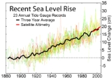
Satellite altimeters have been making precise measurements of sea level since the launch of TOPEX/Poseidon
TOPEX/Poseidon
Launched in 1992, TOPEX/Poseidon was a joint satellite mission between NASA, the U.S. space agency, and CNES, the French space agency, to map ocean surface topography. The first major oceanographic research vessel to sail into space, TOPEX/Poseidon helped revolutionize oceanography by proving the...
in 1992. A joint mission of NASA
NASA
The National Aeronautics and Space Administration is the agency of the United States government that is responsible for the nation's civilian space program and for aeronautics and aerospace research...
and CNES
CNES
The is the French government space agency . Established under President Charles de Gaulle in 1961, its headquarters are located in central Paris and it is under the supervision of the French Ministries of Defence and Research...
, TOPEX/Poseidon was followed by Jason-1 in 2001 and the Ocean Surface Topography Mission
Ocean Surface Topography Mission
The Ocean Surface Topography Mission on the Jason-2 satellite is an international Earth observation satellite mission that continues the sea surface height measurements begun in 1992 by the joint NASA/CNES TOPEX/Poseidon mission and followed by the NASA/CNES Jason-1 mission launched in 2001.Like...
on the Jason-2 satellite in 2008.
Difficulties in utilization
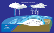
To extend this definition far from the sea means comparing the local height of the mean sea surface with a "level" reference surface, or datum, called the geoidGeoid
The geoid is that equipotential surface which would coincide exactly with the mean ocean surface of the Earth, if the oceans were in equilibrium, at rest , and extended through the continents . According to C.F...
. In a state of rest or absence of external forces, the mean sea level would coincide with this geoid surface, being an equipotential surface of the Earth's gravitational field. In reality, due to currents, air pressure variations, temperature and salinity variations, etc., this does not occur, not even as a long term average. The location-dependent, but persistent in time, separation between mean sea level and the geoid is referred to as (stationary) ocean surface topography
Ocean surface topography
The ocean surface has highs and lows, similar to the hills and valleys of Earth's land surface depicted on a topographic map. These variations, called "ocean surface topography" or "dynamic sea surface topography" are mapped using measurements of sea surface height relative to Earth's geoid...
. It varies globally in a range of ± 2 m.
Traditionally, one had to process sea-level measurements to take into account the effect of the 228-month Metonic cycle
Metonic cycle
In astronomy and calendar studies, the Metonic cycle or Enneadecaeteris is a period of very close to 19 years which is remarkable for being very nearly a common multiple of the solar year and the synodic month...
and the 223-month eclipse cycle
Eclipse cycle
Eclipses may occur repeatedly, separated by certain intervals of time: these intervals are called eclipse cycles. The series of eclipses separated by a repeat of one of these intervals is called an eclipse series.- Eclipse conditions :...
on the tides. Mean sea level is not constant over the surface of the Earth. For instance, mean sea level at the Pacific
Pacific Ocean
The Pacific Ocean is the largest of the Earth's oceanic divisions. It extends from the Arctic in the north to the Southern Ocean in the south, bounded by Asia and Australia in the west, and the Americas in the east.At 165.2 million square kilometres in area, this largest division of the World...
end of the Panama Canal
Panama Canal
The Panama Canal is a ship canal in Panama that joins the Atlantic Ocean and the Pacific Ocean and is a key conduit for international maritime trade. Built from 1904 to 1914, the canal has seen annual traffic rise from about 1,000 ships early on to 14,702 vessels measuring a total of 309.6...
stands 20 cm (7.9 in) higher than at the Atlantic
Atlantic Ocean
The Atlantic Ocean is the second-largest of the world's oceanic divisions. With a total area of about , it covers approximately 20% of the Earth's surface and about 26% of its water surface area...
end.
Sea level and dry land
Several terms are used to describe the changing relationships between sea level and dry land. When the term "relative" is used, it means change relative to a fixed point in the sediment pile. The term "eustatic" refers to global changes in sea level relative to a fixed point, such as the centre of the earth, for example as a result of melting ice-caps. The term "steric" refers to global changes in sea level due to thermal expansionThermal expansion
Thermal expansion is the tendency of matter to change in volume in response to a change in temperature.When a substance is heated, its particles begin moving more and thus usually maintain a greater average separation. Materials which contract with increasing temperature are rare; this effect is...
and salinity
Salinity
Salinity is the saltiness or dissolved salt content of a body of water. It is a general term used to describe the levels of different salts such as sodium chloride, magnesium and calcium sulfates, and bicarbonates...
variations. The term "isostatic" refers to changes in the level of the land relative to a fixed point in the earth, possibly due to thermal buoyancy or tectonic
Tectonics
Tectonics is a field of study within geology concerned generally with the structures within the lithosphere of the Earth and particularly with the forces and movements that have operated in a region to create these structures.Tectonics is concerned with the orogenies and tectonic development of...
effects; it implies no change in the volume of water in the oceans. The melting of glacier
Glacier
A glacier is a large persistent body of ice that forms where the accumulation of snow exceeds its ablation over many years, often centuries. At least 0.1 km² in area and 50 m thick, but often much larger, a glacier slowly deforms and flows due to stresses induced by its weight...
s at the end of ice age
Ice age
An ice age or, more precisely, glacial age, is a generic geological period of long-term reduction in the temperature of the Earth's surface and atmosphere, resulting in the presence or expansion of continental ice sheets, polar ice sheets and alpine glaciers...
s is one example of eustatic sea level rise. The subsidence of land due to the withdrawal of groundwater
Groundwater
Groundwater is water located beneath the ground surface in soil pore spaces and in the fractures of rock formations. A unit of rock or an unconsolidated deposit is called an aquifer when it can yield a usable quantity of water. The depth at which soil pore spaces or fractures and voids in rock...
is an isostatic cause of relative sea level rise. Paleoclimatologists can track sea level by examining the rocks deposited along coasts that are very tectonically stable, like the east coast of North America. Areas like volcanic islands are experiencing relative sea level rise as a result of isostatic cooling of the rock which causes the land to sink.
On other planets that lack a liquid ocean, planetologists can calculate a "mean altitude" by averaging the heights of all points on the surface. This altitude, sometimes referred to as a "sea level", serves equivalently as a reference for the height of planetary features.
Local and eustatic sea level
Ocean surface wave
In fluid dynamics, wind waves or, more precisely, wind-generated waves are surface waves that occur on the free surface of oceans, seas, lakes, rivers, and canals or even on small puddles and ponds. They usually result from the wind blowing over a vast enough stretch of fluid surface. Waves in the...
and tide
Tide
Tides are the rise and fall of sea levels caused by the combined effects of the gravitational forces exerted by the moon and the sun and the rotation of the Earth....
s are smoothed out. One must adjust perceived changes in LMSL to account for vertical movements of the land, which can be of the same order (mm/yr) as sea level changes. Some land movements occur because of isostatic
Isostasy
Isostasy is a term used in geology to refer to the state of gravitational equilibrium between the earth's lithosphere and asthenosphere such that the tectonic plates "float" at an elevation which depends on their thickness and density. This concept is invoked to explain how different topographic...
adjustment of the mantle
Mantle (geology)
The mantle is a part of a terrestrial planet or other rocky body large enough to have differentiation by density. The interior of the Earth, similar to the other terrestrial planets, is chemically divided into layers. The mantle is a highly viscous layer between the crust and the outer core....
to the melting of ice sheet
Ice sheet
An ice sheet is a mass of glacier ice that covers surrounding terrain and is greater than 50,000 km² , thus also known as continental glacier...
s at the end of the last ice age. The weight of the ice sheet depresses the underlying land, and when the ice melts away the land slowly rebounds
Post-glacial rebound
Post-glacial rebound is the rise of land masses that were depressed by the huge weight of ice sheets during the last glacial period, through a process known as isostasy...
. Changes in ground-based ice volume also affect local and regional sea levels by the readjustment of the geoid
Geoid
The geoid is that equipotential surface which would coincide exactly with the mean ocean surface of the Earth, if the oceans were in equilibrium, at rest , and extended through the continents . According to C.F...
and true polar wander
True polar wander
True polar wander is a solid-body rotation of a planet or moon with respect to its spin axis, causing the geographic locations of the North and South Poles to change, or "wander". In a stable state, the largest moments of inertia axis is aligned with the spin axis, with the smaller two moment of...
. Atmospheric pressure
Atmospheric pressure
Atmospheric pressure is the force per unit area exerted into a surface by the weight of air above that surface in the atmosphere of Earth . In most circumstances atmospheric pressure is closely approximated by the hydrostatic pressure caused by the weight of air above the measurement point...
, ocean current
Ocean current
An ocean current is a continuous, directed movement of ocean water generated by the forces acting upon this mean flow, such as breaking waves, wind, Coriolis effect, cabbeling, temperature and salinity differences and tides caused by the gravitational pull of the Moon and the Sun...
s and local ocean temperature
Temperature
Temperature is a physical property of matter that quantitatively expresses the common notions of hot and cold. Objects of low temperature are cold, while various degrees of higher temperatures are referred to as warm or hot...
changes can affect LMSL as well.
Eustatic change (as opposed to local change) results in an alteration to the global sea levels due to changes in either the volume of water in the world oceans or net changes in the volume of the ocean basins.
A more recent theory as to why sea levels have varied so dramatically throughout geologic history is, in part, due to Isostatic Rebound. Part of this new theory states that as denser oceanic plate is subducted under less dense continental plate at a convergence plate boundary with a subduction zone, some of the oceanic plate is pulled downward briefly (geologically speaking) as the oceanic plate sinks into the Earth's Mantle. The Continental crust then bounces back up, restoring its previous position at equilibrium. Recent studies have suggested this was the case with the continent of Australia.
Short term and periodic changes
There are many factors which can produce short-term (a few minutes to 14 months) changes in sea level.| Periodic sea level changes | ||
|---|---|---|
| Diurnal and semidiurnal astronomical tides | 12–24 h P | 0.2–10+ m |
| Long-period tides | ||
| Rotational variations (Chandler wobble Chandler wobble The Chandler wobble is a small motion in the Earth's axis of rotation relative to the Earth's surface, which was discovered by American astronomer Seth Carlo Chandler in 1891. It amounts to on the Earth's surface and has a period of 433 days... ) |
14 month P | |
| Meteorological and oceanographic fluctuations | ||
| Atmospheric pressure | Hours to months | –0.7 to 1.3 m |
| Winds (storm surge Storm surge A storm surge is an offshore rise of water associated with a low pressure weather system, typically tropical cyclones and strong extratropical cyclones. Storm surges are caused primarily by high winds pushing on the ocean's surface. The wind causes the water to pile up higher than the ordinary sea... s) |
1–5 days | Up to 5 m |
| Evaporation Evaporation Evaporation is a type of vaporization of a liquid that occurs only on the surface of a liquid. The other type of vaporization is boiling, which, instead, occurs on the entire mass of the liquid.... and precipitation Precipitation (meteorology) In meteorology, precipitation In meteorology, precipitation In meteorology, precipitation (also known as one of the classes of hydrometeors, which are atmospheric water phenomena is any product of the condensation of atmospheric water vapor that falls under gravity. The main forms of precipitation... (may also follow long-term pattern) |
Days to weeks | |
| Ocean surface topography Topography Topography is the study of Earth's surface shape and features or those ofplanets, moons, and asteroids... (changes in water density Density The mass density or density of a material is defined as its mass per unit volume. The symbol most often used for density is ρ . In some cases , density is also defined as its weight per unit volume; although, this quantity is more properly called specific weight... and currents) |
Days to weeks | Up to 1 m |
| El Niño/southern oscillation | 6 mo every 5–10 yr | Up to 0.6 m |
| Seasonal variations | ||
| Season Season A season is a division of the year, marked by changes in weather, ecology, and hours of daylight.Seasons result from the yearly revolution of the Earth around the Sun and the tilt of the Earth's axis relative to the plane of revolution... al water balance among oceans (Atlantic, Pacific, Indian) |
||
| Seasonal variations in slope of water surface | ||
| River River A river is a natural watercourse, usually freshwater, flowing towards an ocean, a lake, a sea, or another river. In a few cases, a river simply flows into the ground or dries up completely before reaching another body of water. Small rivers may also be called by several other names, including... runoff/flood Flood A flood is an overflow of an expanse of water that submerges land. The EU Floods directive defines a flood as a temporary covering by water of land not normally covered by water... s |
2 months | 1 m |
| Seasonal water density changes (temperature and salinity Salinity Salinity is the saltiness or dissolved salt content of a body of water. It is a general term used to describe the levels of different salts such as sodium chloride, magnesium and calcium sulfates, and bicarbonates... ) |
6 months | 0.2 m |
| Seiches | ||
| Seiche Seiche A seiche is a standing wave in an enclosed or partially enclosed body of water. Seiches and seiche-related phenomena have been observed on lakes, reservoirs, swimming pools, bays, harbors and seas... s (standing waves) |
Minutes to hours | Up to 2 m |
| Earthquake Earthquake An earthquake is the result of a sudden release of energy in the Earth's crust that creates seismic waves. The seismicity, seismism or seismic activity of an area refers to the frequency, type and size of earthquakes experienced over a period of time... s |
||
| Tsunami Tsunami A tsunami is a series of water waves caused by the displacement of a large volume of a body of water, typically an ocean or a large lake... s (generate catastrophic long-period waves) |
Hours | Up to 10 m |
| Abrupt change in land level | Minutes | Up to 10 m |
Long term changes
Density
The mass density or density of a material is defined as its mass per unit volume. The symbol most often used for density is ρ . In some cases , density is also defined as its weight per unit volume; although, this quantity is more properly called specific weight...
and the amounts of water in rivers, lake
Lake
A lake is a body of relatively still fresh or salt water of considerable size, localized in a basin, that is surrounded by land. Lakes are inland and not part of the ocean and therefore are distinct from lagoons, and are larger and deeper than ponds. Lakes can be contrasted with rivers or streams,...
s, glaciers, polar ice cap
Polar ice cap
A polar ice cap is a high latitude region of a planet or natural satellite that is covered in ice. There are no requirements with respect to size or composition for a body of ice to be termed a polar ice cap, nor any geological requirement for it to be over land; only that it must be a body of...
s and sea ice
Sea ice
Sea ice is largely formed from seawater that freezes. Because the oceans consist of saltwater, this occurs below the freezing point of pure water, at about -1.8 °C ....
. Over much longer geological timescales, changes in the shape of the oceanic basins and in land/sea distribution will also affect sea level.
Observational and modelling studies of mass loss from glaciers and ice caps
Retreat of glaciers since 1850
The retreat of glaciers since 1850 affects the availability of fresh water for irrigation and domestic use, mountain recreation, animals and plants that depend on glacier-melt, and in the longer term, the level of the oceans...
indicate a contribution to sea-level rise of 0.2 to 0.4 mm/yr averaged over the 20th century.
Glaciers and ice caps
Each year about 8 mm (0.3 inch) of water from the entire surface of the oceans falls into the Antarctica and GreenlandGeography of Greenland
Greenland is located between the Arctic Ocean and the North Atlantic Ocean, northeast of Canada and northwest of Iceland. Greenland has no land boundaries and 44,087 km of coastline. A sparse population is confined to small settlements along the coast. Greenland possesses the world's second...
ice sheets as snowfall. If no ice returned to the oceans, sea level would drop 8 mm every year. To a first approximation, the same amount of water appeared to return to the ocean in iceberg
Iceberg
An iceberg is a large piece of ice from freshwater that has broken off from a snow-formed glacier or ice shelf and is floating in open water. It may subsequently become frozen into pack ice...
s and from ice melting at the edges. Scientists previously had estimated which is greater, ice going in or coming out, called the mass balance
Glacier mass balance
Crucial to the survival of a glacier is its mass balance, the difference between accumulation and ablation . Climate change may cause variations in both temperature and snowfall, causing changes in mass balance. Changes in mass balance control a glacier's long term behavior and is the most...
, important because it causes changes in global sea level. High-precision gravimetry
Gravimetry
Gravimetry is the measurement of the strength of a gravitational field. Gravimetry may be used when either the magnitude of gravitational field or the properties of matter responsible for its creation are of interest...
from satellites
Gravity Recovery and Climate Experiment
The Gravity Recovery And Climate Experiment , a joint mission of NASA and the German Space Agency, has been making detailed measurements of Earth's gravity field since its launch in March 2002....
in low-noise flight has since determined Greenland is losing billions of tons per year, in accordance with loss estimates from ground measurement.
Ice shelves
Ice shelf
An ice shelf is a thick, floating platform of ice that forms where a glacier or ice sheet flows down to a coastline and onto the ocean surface. Ice shelves are only found in Antarctica, Greenland and Canada. The boundary between the floating ice shelf and the grounded ice that feeds it is called...
float on the surface of the sea and, if they melt, to first order they do not change sea level. Likewise, the melting of the northern polar
North Pole
The North Pole, also known as the Geographic North Pole or Terrestrial North Pole, is, subject to the caveats explained below, defined as the point in the northern hemisphere where the Earth's axis of rotation meets its surface...
ice cap
Ice cap
An ice cap is an ice mass that covers less than 50 000 km² of land area . Masses of ice covering more than 50 000 km² are termed an ice sheet....
which is composed of floating pack ice would not significantly contribute to rising sea levels. Because they are lower in salinity, however, their melting would cause a very small increase in sea levels, so small that it is generally neglected.
- Scientists previously lacked knowledge of changes in terrestrial storage of water. Surveying of water retention by soilSoilSoil is a natural body consisting of layers of mineral constituents of variable thicknesses, which differ from the parent materials in their morphological, physical, chemical, and mineralogical characteristics...
absorption and by reservoirs outright ("impoundment") at just under the volume of Lake SuperiorLake SuperiorLake Superior is the largest of the five traditionally-demarcated Great Lakes of North America. It is bounded to the north by the Canadian province of Ontario and the U.S. state of Minnesota, and to the south by the U.S. states of Wisconsin and Michigan. It is the largest freshwater lake in the...
agreed with a dam-building peak in the 1930s-1970s timespan. Such impoundment masked tens of millimetres of sea level rise in that span. ( B. F. Chao,* Y. H. Wu, Y. S. Li). - If small glacierGlacierA glacier is a large persistent body of ice that forms where the accumulation of snow exceeds its ablation over many years, often centuries. At least 0.1 km² in area and 50 m thick, but often much larger, a glacier slowly deforms and flows due to stresses induced by its weight...
s and polarPolar regionEarth's polar regions are the areas of the globe surrounding the poles also known as frigid zones. The North Pole and South Pole being the centers, these regions are dominated by the polar ice caps, resting respectively on the Arctic Ocean and the continent of Antarctica...
ice caps on the margins of Greenland and the Antarctic PeninsulaAntarctic PeninsulaThe Antarctic Peninsula is the northernmost part of the mainland of Antarctica. It extends from a line between Cape Adams and a point on the mainland south of Eklund Islands....
melt, the projected rise in sea level will be around 0.5 m. Melting of the Greenland ice sheetGreenland ice sheetThe Greenland ice sheet is a vast body of ice covering , roughly 80% of the surface of Greenland. It is the second largest ice body in the world, after the Antarctic Ice Sheet. The ice sheet is almost long in a north-south direction, and its greatest width is at a latitude of 77°N, near its...
would produce 7.2 m of sea-level rise, and melting of the Antarctic ice sheetAntarctic ice sheetThe Antarctic ice sheet is one of the two polar ice caps of the Earth. It covers about 98% of the Antarctic continent and is the largest single mass of ice on Earth. It covers an area of almost 14 million square km and contains 30 million cubic km of ice...
would produce 61.1 m of sea level rise. The collapse of the grounded interior reservoir of the West Antarctic Ice SheetWest Antarctic Ice SheetThe West Antarctic Ice Sheet is the segment of the continental ice sheet that covers West Antarctica, the portion of Antarctica on the side of the Transantarctic Mountains which lies in the Western Hemisphere. The WAIS is classified as a marine-based ice sheet, meaning that its bed lies well...
would raise sea level by 5–6 m. - The snowline altitude is the altitudeAltitudeAltitude or height is defined based on the context in which it is used . As a general definition, altitude is a distance measurement, usually in the vertical or "up" direction, between a reference datum and a point or object. The reference datum also often varies according to the context...
of the lowest elevationElevationThe elevation of a geographic location is its height above a fixed reference point, most commonly a reference geoid, a mathematical model of the Earth's sea level as an equipotential gravitational surface ....
interval in which minimum annual snow cover exceeds 50%. This ranges from about 5,500 metreMetreThe metre , symbol m, is the base unit of length in the International System of Units . Originally intended to be one ten-millionth of the distance from the Earth's equator to the North Pole , its definition has been periodically refined to reflect growing knowledge of metrology...
s above sea-level at the equator down to sea level at about 70° N&S latitudeLatitudeIn geography, the latitude of a location on the Earth is the angular distance of that location south or north of the Equator. The latitude is an angle, and is usually measured in degrees . The equator has a latitude of 0°, the North pole has a latitude of 90° north , and the South pole has a...
, depending on regional temperature amelioration effects. PermafrostPermafrostIn geology, permafrost, cryotic soil or permafrost soil is soil at or below the freezing point of water for two or more years. Ice is not always present, as may be in the case of nonporous bedrock, but it frequently occurs and it may be in amounts exceeding the potential hydraulic saturation of...
then appears at sea level and extends deeper below sea level polewards. - As most of the Greenland and Antarctic ice sheets lie above the snowline and/or base of the permafrost zone, they cannot melt in a timeframe much less than several millennia; therefore it is likely that they will not, through melting, contribute significantly to sea level rise in the coming century. They can, however, do so through acceleration in flow and enhanced iceberg calvingIce calvingIce calving, also known as glacier calving or iceberg calving, is a form of ice ablation or ice disruption. It is the sudden release and breaking away of a mass of ice from a glacier, iceberg, ice front, ice shelf, or crevasse...
. - Climate changeClimate changeClimate change is a significant and lasting change in the statistical distribution of weather patterns over periods ranging from decades to millions of years. It may be a change in average weather conditions or the distribution of events around that average...
s during the 20th century are estimated from modelling studies to have led to contributions of between –0.2 and 0.0 mm/yr from Antarctica (the results of increasing precipitation) and 0.0 to 0.1 mm/yr from Greenland (from changes in both precipitation and runoffSurface runoffSurface runoff is the water flow that occurs when soil is infiltrated to full capacity and excess water from rain, meltwater, or other sources flows over the land. This is a major component of the water cycle. Runoff that occurs on surfaces before reaching a channel is also called a nonpoint source...
). - Estimates suggest that Greenland and Antarctica have contributed 0.0 to 0.5 mm/yr over the 20th century as a result of long-term adjustment to the end of the last ice age.
The current rise in sea level observed from tide gauges, of about 1.8 mm/yr, is within the estimate range from the combination of factors above but active research continues in this field. The terrestrial storage term, thought to be highly uncertain, is no longer positive, and shown to be quite large.
Geological influences
History of Earth
The history of the Earth describes the most important events and fundamental stages in the development of the planet Earth from its formation 4.578 billion years ago to the present day. Nearly all branches of natural science have contributed to the understanding of the main events of the Earth's...
, the configuration of the continents and seafloor have changed due to plate tectonics
Plate tectonics
Plate tectonics is a scientific theory that describes the large scale motions of Earth's lithosphere...
. This affects global sea level by determining the depths of the ocean basins and how glacial-interglacial cycles distribute ice across the Earth.
The depth of the ocean basins is a function of the age of oceanic lithosphere
Oceanic lithosphere
Oceanic lithosphereOceanic lithosphere is typically about 50-100 km thick , while the continental lithosphere has a range in thickness from about 40 km to perhaps 200 km; the upper ~30 to ~50 km of the typical continental lithosphere is crust...
: as lithosphere becomes older, it becomes denser and sinks. Therefore, a configuration with many small oceanic plates that rapidly recycle lithosphere will produce shallower ocean basins and (all other things being equal) higher sea levels. A configuration with fewer plates and more cold, dense oceanic lithosphere, on the other hand, will result in deeper ocean basins and lower sea levels.
When there were large amounts of continental crust
Continental crust
The continental crust is the layer of igneous, sedimentary, and metamorphic rocks which form the continents and the areas of shallow seabed close to their shores, known as continental shelves. This layer is sometimes called sial due to more felsic, or granitic, bulk composition, which lies in...
near the poles, the rock record shows unusually low sea levels during ice ages, because there was lots of polar land mass upon which snow and ice could accumulate. During times when the land masses clustered around the equator, ice ages had much less effect on sea level.
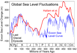
Over most of geologic time, long-term sea level has been higher than today (see graph above). Only at the Permian
Permian
The PermianThe term "Permian" was introduced into geology in 1841 by Sir Sir R. I. Murchison, president of the Geological Society of London, who identified typical strata in extensive Russian explorations undertaken with Edouard de Verneuil; Murchison asserted in 1841 that he named his "Permian...
-Triassic
Triassic
The Triassic is a geologic period and system that extends from about 250 to 200 Mya . As the first period of the Mesozoic Era, the Triassic follows the Permian and is followed by the Jurassic. Both the start and end of the Triassic are marked by major extinction events...
boundary ~250 million years ago was long-term sea level lower than today. Long term changes in sea level are the result of changes in the oceanic crust
Oceanic crust
Oceanic crust is the part of Earth's lithosphere that surfaces in the ocean basins. Oceanic crust is primarily composed of mafic rocks, or sima, which is rich in iron and magnesium...
, with a downward trend expected to continue in the very long term.
During the glacial/interglacial cycles over the past few million years, sea level has varied by somewhat more than a hundred metre
Metre
The metre , symbol m, is the base unit of length in the International System of Units . Originally intended to be one ten-millionth of the distance from the Earth's equator to the North Pole , its definition has been periodically refined to reflect growing knowledge of metrology...
s. This is primarily due to the growth and decay of ice sheets (mostly in the northern hemisphere) with water evaporated from the sea.
The Mediterranean Basin
Mediterranean Basin
In biogeography, the Mediterranean Basin refers to the lands around the Mediterranean Sea that have a Mediterranean climate, with mild, rainy winters and hot, dry summers, which supports characteristic Mediterranean forests, woodlands, and scrub vegetation...
's gradual growth as the Neotethys basin, begun in the Jurassic
Jurassic
The Jurassic is a geologic period and system that extends from about Mya to Mya, that is, from the end of the Triassic to the beginning of the Cretaceous. The Jurassic constitutes the middle period of the Mesozoic era, also known as the age of reptiles. The start of the period is marked by...
, did not suddenly affect ocean levels. While the Mediterranean was forming during the past 100 million years, the average ocean level was generally 200 metre
Metre
The metre , symbol m, is the base unit of length in the International System of Units . Originally intended to be one ten-millionth of the distance from the Earth's equator to the North Pole , its definition has been periodically refined to reflect growing knowledge of metrology...
s above current levels. However, the largest known example of marine flooding was when the Atlantic
Atlantic Ocean
The Atlantic Ocean is the second-largest of the world's oceanic divisions. With a total area of about , it covers approximately 20% of the Earth's surface and about 26% of its water surface area...
breached the Strait of Gibraltar
Strait of Gibraltar
The Strait of Gibraltar is a narrow strait that connects the Atlantic Ocean to the Mediterranean Sea and separates Spain in Europe from Morocco in Africa. The name comes from Gibraltar, which in turn originates from the Arabic Jebel Tariq , albeit the Arab name for the Strait is Bab el-Zakat or...
at the end of the Messinian Salinity Crisis
Messinian salinity crisis
The Messinian Salinity Crisis, also referred to as the Messinian Event, and in its latest stage as the Lago Mare event, was a geological event during which the Mediterranean Sea went into a cycle of partly or nearly complete desiccation throughout the latter part of the Messinian age of the Miocene...
about 5.2 million years ago. This restored Mediterranean sea levels at the sudden end of the period when that basin had dried up, apparently due to geologic
Geology
Geology is the science comprising the study of solid Earth, the rocks of which it is composed, and the processes by which it evolves. Geology gives insight into the history of the Earth, as it provides the primary evidence for plate tectonics, the evolutionary history of life, and past climates...
forces in the area of the Strait.
| Long-term causes | Range of effect | Vertical effect |
|---|---|---|
| Change in volume of ocean basins | ||
| Plate tectonics Plate tectonics Plate tectonics is a scientific theory that describes the large scale motions of Earth's lithosphere... and seafloor spreading Seafloor spreading Seafloor spreading is a process that occurs at mid-ocean ridges, where new oceanic crust is formed through volcanic activity and then gradually moves away from the ridge. Seafloor spreading helps explain continental drift in the theory of plate tectonics.... (plate divergence/convergence) and change in seafloor elevation (mid-ocean volcanism) |
Eustatic | 0.01 mm/yr |
| Marine sedimentation | Eustatic | < 0.01 mm/yr |
| Change in mass of ocean water | ||
| Melting or accumulation of continental ice | Eustatic | 10 mm/yr |
| • Climate changes during the 20th century | ||
| •• Antarctica (the results of increasing precipitation) | Eustatic | -0.2 to 0.0 mm/yr |
| •• Greenland (from changes in both precipitation and runoff) | Eustatic | 0.0 to 0.1 mm/yr |
| • Long-term adjustment to the end of the last ice age | ||
| •• Greenland and Antarctica contribution over 20th century | Eustatic | 0.0 to 0.5 mm/yr |
| Release of water from earth's interior | Eustatic | |
| Release or accumulation of continental hydrologic reservoirs | Eustatic | |
| Uplift or subsidence of Earth's surface (Isostasy Isostasy Isostasy is a term used in geology to refer to the state of gravitational equilibrium between the earth's lithosphere and asthenosphere such that the tectonic plates "float" at an elevation which depends on their thickness and density. This concept is invoked to explain how different topographic... ) |
||
| Thermal-isostasy (temperature/density changes in earth's interior) | Local effect | |
| Glacio-isostasy (loading or unloading of ice) | Local effect | 10 mm/yr |
| Hydro-isostasy (loading or unloading of water) | Local effect | |
| Volcano Volcano 2. Bedrock3. Conduit 4. Base5. Sill6. Dike7. Layers of ash emitted by the volcano8. Flank| 9. Layers of lava emitted by the volcano10. Throat11. Parasitic cone12. Lava flow13. Vent14. Crater15... -isostasy (magmatic extrusions) |
Local effect | |
| Sediment-isostasy (deposition and erosion of sediments) | Local effect | < 4 mm/yr |
| Tectonic uplift/subsidence | ||
| Vertical and horizontal motions of crust (in response to fault motions) | Local effect | 1–3 mm/yr |
| Sediment compaction | ||
| Sediment compression into denser matrix (particularly significant in and near river delta River delta A delta is a landform that is formed at the mouth of a river where that river flows into an ocean, sea, estuary, lake, reservoir, flat arid area, or another river. Deltas are formed from the deposition of the sediment carried by the river as the flow leaves the mouth of the river... s) |
Local effect | |
| Loss of interstitial fluids (withdrawal of groundwater Groundwater Groundwater is water located beneath the ground surface in soil pore spaces and in the fractures of rock formations. A unit of rock or an unconsolidated deposit is called an aquifer when it can yield a usable quantity of water. The depth at which soil pore spaces or fractures and voids in rock... or oil Petroleum Petroleum or crude oil is a naturally occurring, flammable liquid consisting of a complex mixture of hydrocarbons of various molecular weights and other liquid organic compounds, that are found in geologic formations beneath the Earth's surface. Petroleum is recovered mostly through oil drilling... ) |
Local effect | ≤ 55 mm/yr |
| Earthquake-induced vibration | Local effect | |
| Departure from geoid | ||
| Shifts in hydrosphere Hydrosphere A hydrosphere in physical geography describes the combined mass of water found on, under, and over the surface of a planet.... , aesthenosphere, core-mantle interface |
Local effect | |
| Shifts in earth's rotation, axis of spin, and precession of equinox Equinox An equinox occurs twice a year, when the tilt of the Earth's axis is inclined neither away from nor towards the Sun, the center of the Sun being in the same plane as the Earth's equator... |
Eustatic | |
| External gravitational changes | Eustatic | |
| Evaporation and precipitation (if due to a long-term pattern) | Local effect | |
Changes through geologic time
Permian
The PermianThe term "Permian" was introduced into geology in 1841 by Sir Sir R. I. Murchison, president of the Geological Society of London, who identified typical strata in extensive Russian explorations undertaken with Edouard de Verneuil; Murchison asserted in 1841 that he named his "Permian...
-Triassic
Triassic
The Triassic is a geologic period and system that extends from about 250 to 200 Mya . As the first period of the Mesozoic Era, the Triassic follows the Permian and is followed by the Jurassic. Both the start and end of the Triassic are marked by major extinction events...
boundary about 250 million years ago).
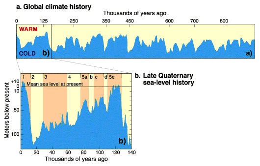
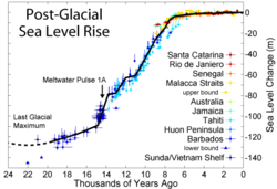
During the most recent ice age (at its maximum about 20,000 years ago) the world's sea level was about 130 m lower than today, due to the large amount of sea water that had evaporated and been deposited as snow
Snow
Snow is a form of precipitation within the Earth's atmosphere in the form of crystalline water ice, consisting of a multitude of snowflakes that fall from clouds. Since snow is composed of small ice particles, it is a granular material. It has an open and therefore soft structure, unless packed by...
and ice
Ice
Ice is water frozen into the solid state. Usually ice is the phase known as ice Ih, which is the most abundant of the varying solid phases on the Earth's surface. It can appear transparent or opaque bluish-white color, depending on the presence of impurities or air inclusions...
, mostly in the Laurentide ice sheet
Laurentide ice sheet
The Laurentide Ice Sheet was a massive sheet of ice that covered hundreds of thousands of square miles, including most of Canada and a large portion of the northern United States, multiple times during Quaternary glacial epochs. It last covered most of northern North America between c. 95,000 and...
. The majority of this had melted by about 10,000 years ago.
Hundreds of similar glacial cycles have occurred throughout the Earth's history
History of Earth
The history of the Earth describes the most important events and fundamental stages in the development of the planet Earth from its formation 4.578 billion years ago to the present day. Nearly all branches of natural science have contributed to the understanding of the main events of the Earth's...
. Geologists who study the positions of coastal sediment deposits through time have noted dozens of similar basinward shifts of shorelines associated with a later recovery. This results in sediment
Sediment
Sediment is naturally occurring material that is broken down by processes of weathering and erosion, and is subsequently transported by the action of fluids such as wind, water, or ice, and/or by the force of gravity acting on the particle itself....
ary cycles which in some cases can be correlated around the world with great confidence. This relatively new branch of geological science linking eustatic sea level to sedimentary deposits is called sequence stratigraphy
Sequence stratigraphy
Sequence stratigraphy is a branch of geology that attempts to subdivide and link sedimentary deposits into unconformity bound units on a variety of scales and explain these stratigraphic units in terms of variations in sediment supply and variations in the rate of change in accommodation space...
.
The most up-to-date chronology of sea level change during the Phanerozoic
Phanerozoic
The Phanerozoic Eon is the current eon in the geologic timescale, and the one during which abundant animal life has existed. It covers roughly 542 million years and goes back to the time when diverse hard-shelled animals first appeared...
shows the following long term trends:
- Gradually rising sea level through the CambrianCambrianThe Cambrian is the first geological period of the Paleozoic Era, lasting from Mya ; it is succeeded by the Ordovician. Its subdivisions, and indeed its base, are somewhat in flux. The period was established by Adam Sedgwick, who named it after Cambria, the Latin name for Wales, where Britain's...
- Relatively stable sea level in the OrdovicianOrdovicianThe Ordovician is a geologic period and system, the second of six of the Paleozoic Era, and covers the time between 488.3±1.7 to 443.7±1.5 million years ago . It follows the Cambrian Period and is followed by the Silurian Period...
, with a large drop associated with the end-Ordovician glaciation - Relative stability at the lower level during the SilurianSilurianThe Silurian is a geologic period and system that extends from the end of the Ordovician Period, about 443.7 ± 1.5 Mya , to the beginning of the Devonian Period, about 416.0 ± 2.8 Mya . As with other geologic periods, the rock beds that define the period's start and end are well identified, but the...
- A gradual fall through the DevonianDevonianThe Devonian is a geologic period and system of the Paleozoic Era spanning from the end of the Silurian Period, about 416.0 ± 2.8 Mya , to the beginning of the Carboniferous Period, about 359.2 ± 2.5 Mya...
, continuing through the Mississippian to long-term low at the Mississippian/PennsylvanianPennsylvanianThe Pennsylvanian is, in the ICS geologic timescale, the younger of two subperiods of the Carboniferous Period. It lasted from roughly . As with most other geochronologic units, the rock beds that define the Pennsylvanian are well identified, but the exact date of the start and end are uncertain...
boundary - A gradual rise until the start of the PermianPermianThe PermianThe term "Permian" was introduced into geology in 1841 by Sir Sir R. I. Murchison, president of the Geological Society of London, who identified typical strata in extensive Russian explorations undertaken with Edouard de Verneuil; Murchison asserted in 1841 that he named his "Permian...
, followed by a gentle decrease lasting until the MesozoicMesozoicThe Mesozoic era is an interval of geological time from about 250 million years ago to about 65 million years ago. It is often referred to as the age of reptiles because reptiles, namely dinosaurs, were the dominant terrestrial and marine vertebrates of the time...
.
Recent changes
For at least the last 100 years, sea level has been rising at an average rate of about 1.8 mm per year. The majority of this rise can be attributed to the increase in temperature of the sea and the resulting thermal expansion of sea water. Additional contributions come from water sources on land such as melting snow and glaciers (see global warmingGlobal warming
Global warming refers to the rising average temperature of Earth's atmosphere and oceans and its projected continuation. In the last 100 years, Earth's average surface temperature increased by about with about two thirds of the increase occurring over just the last three decades...
).
Aviation
Using pressure to measure altitude results in two other types of altitude. Distance above true or MSL (mean sea level) is the next best measurement to absolute. MSL altitude is the distance above where sea level would be if there were no land. If one knows the elevation of terrain, the distance above the ground is calculated by a simple subtraction.An MSL altitude—called pressure altitude
Pressure altitude
In aviation, pressure altitude is the indicated altitude when an altimeter is set to an agreed baseline pressure setting. The baseline pressure is 1013.25 hPa, equivalent to 1013.25 millibar, or 29.92 inches of mercury. This setting is equivalent to the air pressure at mean sea level in the...
by pilots—is useful for predicting physiological responses in unpressurized aircraft (see hypoxia
Hypoxia (medical)
Hypoxia, or hypoxiation, is a pathological condition in which the body as a whole or a region of the body is deprived of adequate oxygen supply. Variations in arterial oxygen concentrations can be part of the normal physiology, for example, during strenuous physical exercise...
). It also correlates with engine, propeller, and wing performance, which all decrease in thinner air.
Pilots can estimate height above terrain with an altimeter
Altimeter
An altimeter is an instrument used to measure the altitude of an object above a fixed level. The measurement of altitude is called altimetry, which is related to the term bathymetry, the measurement of depth underwater.-Pressure altimeter:...
set to a defined barometric pressure. Generally, the pressure used to set the altimeter is the barometric pressure that would exist at MSL in the region being flown over. This pressure is referred to as either QNH
QNH
QNH is one of the many Q codes. It is defined as, "barometric pressure adjusted to sea level." It is a pressure setting used by pilots, air traffic control , and low frequency weather beacons to refer to the barometric setting which, when set on an aircraft's altimeter, will cause the altimeter to...
or "altimeter" and is transmitted to the pilot by radio from air traffic control
Air traffic control
Air traffic control is a service provided by ground-based controllers who direct aircraft on the ground and in the air. The primary purpose of ATC systems worldwide is to separate aircraft to prevent collisions, to organize and expedite the flow of traffic, and to provide information and other...
(ATC) or an Automatic Terminal Information Service
Automatic Terminal Information Service
Automatic Terminal Information Service, or ATIS, is a continuous broadcast of recorded noncontrol information in busier terminal areas. ATIS broadcasts contain essential information, such as weather information, which runways are active, available approaches, and any other information required by...
(ATIS). Since the terrain elevation is also referenced to MSL, the pilot can estimate height above ground by subtracting the terrain altitude from the altimeter reading. Aviation charts are divided into boxes and the maximum terrain altitude from MSL in each box is clearly indicated. Once above the transition altitude (see below), the altimeter is set to the international standard atmosphere
International Standard Atmosphere
The International Standard Atmosphere is an atmospheric model of how the pressure, temperature, density, and viscosity of the Earth's atmosphere change over a wide range of altitudes. It has been established to provide a common reference for temperature and pressure and consists of tables of...
(ISA) pressure at MSL which is 1013.2 HPa or 29.92 inHg.
Flight level
MSL is useful for aircraft to avoid terrain, but at high enough altitudes, there is no terrain to avoid. Above that level, pilots are primarily interested in avoiding each other, so adjust their altimeter to standard temperature and pressure conditions (average sea level pressure and temperature) and disregard actual barometric pressure—until descending below transition level. To distinguish from MSL, such altitudes are called flight levelFlight level
A Flight Level is a standard nominal altitude of an aircraft, in hundreds of feet. This altitude is calculated from the International standard pressure datum of 1013.25 hPa , the average sea-level pressure, and therefore is not necessarily the same as the aircraft's true altitude either...
s. Standard pilot shorthand is to express flight level as hundreds of feet, so FL 240 is 24000 feet (7,315.2 m). Pilots use the international standard pressure setting of 1013.25 hPa (29.92 inHg) when referring to Flight Levels. The altitude at which aircraft are mandated to set their altimeter to flight levels is called "transition altitude". It varies from country to country. For example in the U.S. it is 18,000 feet, in many European countries it is 3,000 or 5,000 feet.
See also
- Above mean sea levelAbove mean sea levelThe term above mean sea level refers to the elevation or altitude of any object, relative to the average sea level datum. AMSL is used extensively in radio by engineers to determine the coverage area a station will be able to reach...
- Flood myth
- Geopotential heightGeopotential heightGeopotential height is a vertical coordinate referenced to Earth's mean sea level — an adjustment to geometric height using the variation of gravity with latitude and elevation. Thus it can be considered a "gravity-adjusted height"...
- List of places on land with elevations below sea level
- Marine terraceMarine terraceA marine terrace, coastal terrace, raised beach or perched coastline is a relatively flat, horizontal or gently inclined surface of marine origin, mostly an old abrasion platform which has been lifted out of the sphere of wave activity . Thus it lies above or under the current sea level, depending...
- Normal heightNormal heightNormal heights are heights above sea level, one of several types of height which are all computed slightly differently. Alternatives are: orthometric heights and dynamic heights....
- Normaal Amsterdams PeilNormaal Amsterdams PeilNormaal Amsterdams Peil or Amsterdam Ordnance Datum is a vertical datum in use in large parts of Western Europe. Originally created for use in the Netherlands, it was adopted by Prussia in 1879 under the name Normalnull, and in 1955 by other European countries.Mayor Johannes Hudde of Amsterdam in...
- NormalhöhennullNormalhöhennullNormalhöhennull or NHN is a standard reference level, the equivalent of sea level, used in Germany to measure height....
- North West Shelf Operational Oceanographic SystemNorth West Shelf Operational Oceanographic SystemThe North West Shelf Operational Oceanographic System monitors real-time sea levels for the North Sea area. NOOS is operated by partners from the nine countries bordering the extended North Sea and European North West Shelf; Belgium, Denmark, France, Germany, Ireland, Netherlands, Norway, Sweden,...
- Orthometric heightOrthometric heightThe orthometric height is the distance H along a line of force from a given point P at the physical surface of an object to the geoid.Orthometric heights are what are usually used in the US for ordinary engineering work. Values for measured points can be obtained from the National Geodetic Survey...
- Sea level rise
- Standard sea levelStandard sea levelStandard Sea Level defines a set of conditions for physical calculations.The term standard sea level is used to indicate that values of properties are to be taken to be the same as those standard at sea level, and is done to define values for use in general calculations.-Atmospheric properties:At...
- World Geodetic SystemWorld Geodetic SystemThe World Geodetic System is a standard for use in cartography, geodesy, and navigation. It comprises a standard coordinate frame for the Earth, a standard spheroidal reference surface for raw altitude data, and a gravitational equipotential surface that defines the nominal sea level.The latest...
- Meltwater pulse 1AMeltwater pulse 1AMeltwater pulse 1A was an instance in the sea level rise of about 20 m in less than 500 years, perhaps just 200 years. The meltwater event occurred in a period of rapid climate change when the Holocene glacial retreat was going on during the end of the last ice age...
External links
- Sea Level Rise:Understanding the past - Improving projections for the future
- Permanent Service for Mean Sea Level
- Global sea level change: Determination and interpretation
- Environment Protection Agency Sea level rise reports
- Properties of isostasy and eustasy
- Measuring Sea Level from Space
- Rising Tide Video: Scripps Institution of Oceanography
- Sea Levels Online: National Ocean Service (CO-OPS)
- Système d'Observation du Niveau des Eaux Littorales (SONEL)