
World Geodetic System
Encyclopedia
The World Geodetic System is a standard for use in cartography
, geodesy
, and navigation
. It comprises a standard coordinate frame for the Earth
, a standard spheroid
al reference surface (the datum or reference ellipsoid
) for raw altitude
data, and a gravitation
al equipotential surface
(the geoid
) that defines the nominal sea level.
The latest revision is WGS 84 (dating from 1984 and last revised in 2004), which will be valid up to about 2010. Earlier schemes included WGS 72, WGS 66, and WGS 60. WGS 84 is the reference coordinate system used by the Global Positioning System
.
; the error is believed to be less than 2 cm.
The WGS 84 meridian of zero longitude is the IERS Reference Meridian, 5.31 arc seconds
east of the Greenwich
Prime Meridian
, or 102.5 metres (336.3 feet) at the latitude of the Royal Observatory
.
The WGS 84 datum surface is an oblate spheroid (ellipsoid) with major (transverse) radius a = 6,378,137 m at the equator
and flattening f = 1/298.257223563. The polar semi-minor (conjugate) radius b then equals a times (1 - f), or 6356752.3142 m.
Presently WGS 84 uses the 1996 Earth Gravitational Model
(EGM96) geoid, revised in 2004. This geoid defines the nominal sea level surface by means of a spherical harmonics
series of degree 360 (which provides about 100 km horizontal resolution). The deviations of the EGM96 geoid from the WGS 84 reference ellipsoid range from about -105 m to about +85 m. EGM96 differs from the original WGS 84 geoid, referred to as EGM84.
systems began in the 19th century with F.R. Helmert's
famous books (Mathematical and Physical Theory of Physical Geodesy). Austria
and Germany
founded the Zentralbüro für die Internationale Erdmessung (Central Bureau of International Geodesy
), and a series of global ellipsoids of the Earth were derived (e.g., Helmert 1906, Hayford
1910/ 1924).
A unified geodetic system for the whole world became essential in the 1950s for several reasons:
In the late 1950s, the United States Department of Defense
, together with scientist
s of other institutions and countries, began to develop the needed world system to which geodetic data could be referred and compatibility established between the coordinates of widely separated sites of interest. Efforts of the U.S. Army, Navy and Air Force were combined leading to the DoD World Geodetic System 1960 (WGS 60). The term datum as used here refers to a smooth surface somewhat arbitrarily defined as zero elevation, consistent with a set of surveyor's measures of distances between various stations, and differences in elevation, all reduced to a grid of latitude
s, longitude
s, and elevation
s. Heritage surveying methods found elevation differences from a local horizontal determined by the spirit level
, plumb line
, or an equivalent device that depends on the local gravity field (see physical geodesy
). As a result, the elevations in the data are referenced to the geoid
, a surface that is not readily found using satellite geodesy
. The latter observational method is more suitable for global mapping. Therefore, a motivation, and a substantial problem in the WGS and similar work is to patch together data that were not only made separately, for different regions, but to re-reference the elevations to an ellipsoid model rather than to the geoid
.
In accomplishing WGS 60, a combination of available surface gravity data, astro-geodetic
data and results from HIRAN and Canadian SHORAN
surveys were used to define a best-fitting ellipsoid and an earth-centered orientation for each of initially selected datum. (Every datum is relatively oriented with respect to different portions of the geoid by the astro-geodetic methods already described.) The sole contribution of satellite
data to the development of WGS 60 was a value for the ellipsoid flattening which was obtained from the nodal motion of a satellite.
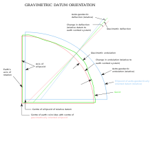 Prior to WGS 60, the U.S. Army and U.S. Air Force had each developed a world system by using different approaches to the gravimetric datum orientation method. To determine their gravimetric orientation parameters, the Air Force used the mean of the differences between the gravimetric and astro-geodetic deflections
and geoid heights (undulations) at specifically selected stations in the areas of the major datums. The Army performed an adjustment to minimize the difference between astro-geodetic and gravimetric geoid
s. By matching the relative astro-geodetic geoids of the selected datums with an earth-centered gravimetric geoid, the selected datums were reduced to an earth-centered orientation. Since the Army and Air Force systems agreed remarkably well for the NAD, ED and TD areas, they were consolidated and became WGS 60.
and the astronautic Mercury datum. In January 1966, a World Geodetic System Committee composed of representatives from the United States Army, Navy and Air Force, was charged with the responsibility of developing an improved WGS needed to satisfy map
ping, charting and geodetic requirements. Additional surface gravity observations, results from the extension of triangulation
and trilateration
networks, and large amounts of Doppler
and optical satellite data had become available since the development of WGS 60. Using the additional data and improved techniques, WGS 66 was produced which served DoD needs for about five years after its implementation in 1967. The defining parameters of the WGS 66 Ellipsoid were the flattening (1/298.25), determined from satellite data and the semimajor axis (6,378,145 meters), determined from a combination of Doppler satellite and astro-geodetic data. A worldwide 5° × 5° mean free air gravity anomaly
field provided the basic data for producing the WGS 66 gravimetric geoid. Also, a geoid referenced to the WGS 66 Ellipsoid was derived from available astrogeodetic data to provide a detailed representation of limited land areas.
adjustment). The results of the adjustment consisted of corrections to initial station coordinates and coefficients of the gravitational field.
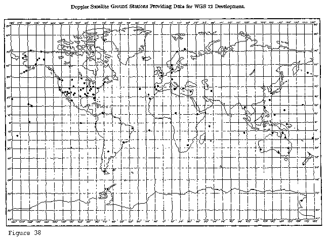
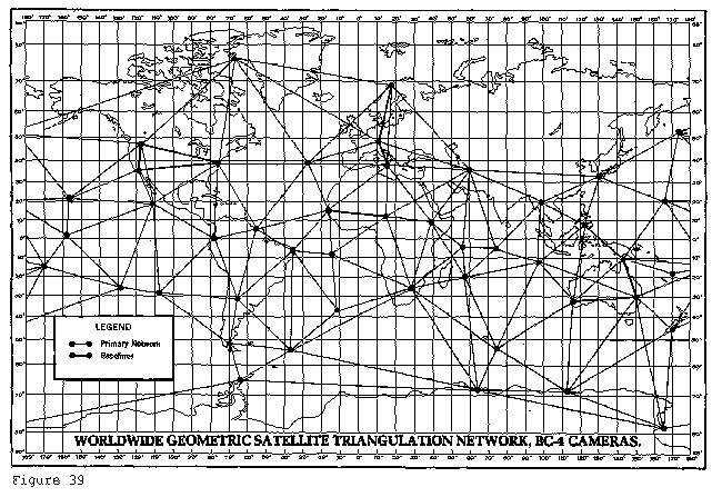
The largest collection of data ever used for WGS purposes was assembled, processed and applied in the development of WGS 72. Both optical and electronic satellite data were used. The electronic satellite data consisted, in part, of Doppler data provided by the U.S. Navy and cooperating non-DoD satellite tracking stations established in support of the Navy's Navigational Satellite System (NNSS). Doppler data was also available from the numerous sites established by GEOCEIVERS during 1971 and 1972. Doppler data was the primary data source for WGS 72 (Figure 38). Additional electronic satellite data was provided by the SECOR (Sequential Collation of Range) Equatorial Network completed by the U.S. Army in 1970. Optical satellite data from the Worldwide Geometric Satellite Triangulation Program was provided by the BC-4 camera system (Figure 39). Data from the Smithsonian Astrophysical Observatory
was also used which included camera (Baker Nunn) and some laser ranging.
 The surface gravity field used in the Unified WGS Solution consisted of a set of 410 10° × 10° equal area mean free air gravity anomalies determined solely from terrestrial data. This gravity field includes mean anomaly values compiled directly from observed gravity data wherever the latter was available in sufficient quantity. The value for areas of sparse or no observational data were developed from geophysically compatible gravity approximations using gravity-geophysical correlation techniques. Approximately 45 percent of the 410 mean free air gravity anomaly values were determined directly from observed gravity data.
The astrogeodetic data in its basic form consists of deflection of the vertical components referred to the various national geodetic datums. These deflection values were integrated into astrogeodetic geoid charts referred to these national datums. The geoid heights contributed to the Unified WGS Solution by providing additional and more detailed data for land areas. Conventional ground survey data was included in the solution to enforce a consistent adjustment of the coordinates of neighboring observation sites of the BC-4, SECOR, Doppler and Baker-Nunn systems. Also, eight geodimeter long line precise traverses were included for the purpose of controlling the scale of the solution.
The Unified WGS Solution, as stated above, was a solution for geodetic positions and associated parameters of the gravitational field based on an optimum combination of available data. The WGS 72 ellipsoid parameters, datum shifts and other associated constants were derived separately. For the unified solution, a normal equation matrix was formed based on each of the mentioned data sets. Then, the individual normal equation matrices were combined and the resultant matrix solved to obtain the positions and the parameters.
The value for the semimajor axis (a) of the WGS 72 Ellipsoid is 6 378 135 meters. The adoption of an a-value 10 meters smaller than that for the WGS 66 Ellipsoid was based on several calculations and indicators including a combination of satellite and surface gravity data for position and gravitational field determinations. Sets of satellite derived station coordinates and gravimetric deflection of the vertical and geoid height data were used to determine local-to-geocentric datum shifts, datum rotation parameters, a datum scale parameter and a value for the semimajor axis of the WGS Ellipsoid. Eight solutions were made with the various sets of input data, both from an investigative point of view and also because of the limited number of unknowns which could be solved for in any individual solution due to computer limitations. Selected Doppler satellite tracking and astro-geodetic datum orientation stations were included in the various solutions. Based on these results and other related studies accomplished by the Committee, an a-value of 6 378 135 meters and a flattening of 1/298.26 were adopted.
In the development of local-to WGS 72 datum shifts, results from different geodetic disciplines were investigated, analyzed and compared. Those shifts adopted were based primarily on a large number of Doppler TRANET and GEOCEIVER station coordinates which were available worldwide. These coordinates had been determined using the Doppler point positioning method.
parameters together with available Doppler, satellite laser ranging and Very Long Baseline Interferometry (VLBI) observations constituted significant new information. An outstanding new source of data had become available from satellite radar altimetry. Also available was an advanced least squares
method called collocation which allowed for a consistent combination solution from different types of measurements all relative to the Earth's gravity field, i.e. geoid, gravity anomalies, deflections, dynamic Doppler, etc.
The new World Geodetic System was called WGS 84. It is currently the reference system being used by the Global Positioning System
. It is geocentric and globally consistent within ±1 m. Current geodetic realizations of the geocentric reference system family International Terrestrial Reference System
(ITRS) maintained by the IERS
are geocentric, and internally consistent, at the few-cm level, while still being metre-level consistent with WGS 84.
The WGS 84 originally used the GRS 80 reference ellipsoid
, but has undergone some minor refinements in later editions since its initial publication. Most of these refinements are important for high-precision orbital calculations for satellites but have little practical effect on typical topographical uses. The following table lists the primary ellipsoid parameters.
The very small difference in the flattening thus results in a—very theoretical—difference of 0.105 mm in the semi polar axis. For most purposes, the differing polar axes can be merged to 6 356 752.3 m, with the inverse flattening rounded to 298.257.
, which was defined by compilation of star observations in different countries. The mean of this data caused a shift of about 100 metres east away from the Prime Meridian
at Greenwich
, UK
.
The longitude positions on WGS 84 agree with those on the older North American Datum 1927
at roughly 85° longitude west, in the east-central United States
.
" (EGM96
), first published in 1996, with revisions as recent as 2004. This model has the same reference ellipsoid as WGS 84, but has a higher-fidelity geoid (roughly 100 km resolution versus 200 km for the original WGS 84).
Many of the original authors of WGS 84 contributed to a new higher fidelity model, called EGM2008. This new model will have a geoid with a resolution approaching 10 km, requiring over 4.6 million terms in the spherical expansion (versus 130,317 in EGM96 and 32,757 in WGS 84).
The first version of this text was taken from the public domain
booklet Geodesy for the Layman at http://www.ngs.noaa.gov/PUBS_LIB/Geodesy4Layman/TR80003E.HTM#ZZ11 -- please Wikify as necessary. This document was written in 1984 and may need to be updated.
Cartography
Cartography is the study and practice of making maps. Combining science, aesthetics, and technique, cartography builds on the premise that reality can be modeled in ways that communicate spatial information effectively.The fundamental problems of traditional cartography are to:*Set the map's...
, geodesy
Geodesy
Geodesy , also named geodetics, a branch of earth sciences, is the scientific discipline that deals with the measurement and representation of the Earth, including its gravitational field, in a three-dimensional time-varying space. Geodesists also study geodynamical phenomena such as crustal...
, and navigation
Navigation
Navigation is the process of monitoring and controlling the movement of a craft or vehicle from one place to another. It is also the term of art used for the specialized knowledge used by navigators to perform navigation tasks...
. It comprises a standard coordinate frame for the Earth
Earth
Earth is the third planet from the Sun, and the densest and fifth-largest of the eight planets in the Solar System. It is also the largest of the Solar System's four terrestrial planets...
, a standard spheroid
Spheroid
A spheroid, or ellipsoid of revolution is a quadric surface obtained by rotating an ellipse about one of its principal axes; in other words, an ellipsoid with two equal semi-diameters....
al reference surface (the datum or reference ellipsoid
Reference ellipsoid
In geodesy, a reference ellipsoid is a mathematically-defined surface that approximates the geoid, the truer figure of the Earth, or other planetary body....
) for raw altitude
Altitude
Altitude or height is defined based on the context in which it is used . As a general definition, altitude is a distance measurement, usually in the vertical or "up" direction, between a reference datum and a point or object. The reference datum also often varies according to the context...
data, and a gravitation
Gravitation
Gravitation, or gravity, is a natural phenomenon by which physical bodies attract with a force proportional to their mass. Gravitation is most familiar as the agent that gives weight to objects with mass and causes them to fall to the ground when dropped...
al equipotential surface
Equipotential surface
Equipotential surfaces are surfaces of constant scalar potential. They are used to visualize an -dimensional scalar potential function in dimensional space...
(the geoid
Geoid
The geoid is that equipotential surface which would coincide exactly with the mean ocean surface of the Earth, if the oceans were in equilibrium, at rest , and extended through the continents . According to C.F...
) that defines the nominal sea level.
The latest revision is WGS 84 (dating from 1984 and last revised in 2004), which will be valid up to about 2010. Earlier schemes included WGS 72, WGS 66, and WGS 60. WGS 84 is the reference coordinate system used by the Global Positioning System
Global Positioning System
The Global Positioning System is a space-based global navigation satellite system that provides location and time information in all weather, anywhere on or near the Earth, where there is an unobstructed line of sight to four or more GPS satellites...
.
Main parameters
The coordinate origin of WGS 84 is meant to be located at the Earth's center of massCenter of mass
In physics, the center of mass or barycenter of a system is the average location of all of its mass. In the case of a rigid body, the position of the center of mass is fixed in relation to the body...
; the error is believed to be less than 2 cm.
The WGS 84 meridian of zero longitude is the IERS Reference Meridian, 5.31 arc seconds
Minute of arc
A minute of arc, arcminute, or minute of angle , is a unit of angular measurement equal to one sixtieth of one degree. In turn, a second of arc or arcsecond is one sixtieth of one minute of arc....
east of the Greenwich
Greenwich
Greenwich is a district of south London, England, located in the London Borough of Greenwich.Greenwich is best known for its maritime history and for giving its name to the Greenwich Meridian and Greenwich Mean Time...
Prime Meridian
Prime Meridian
The Prime Meridian is the meridian at which the longitude is defined to be 0°.The Prime Meridian and its opposite the 180th meridian , which the International Date Line generally follows, form a great circle that divides the Earth into the Eastern and Western Hemispheres.An international...
, or 102.5 metres (336.3 feet) at the latitude of the Royal Observatory
Royal Observatory, Greenwich
The Royal Observatory, Greenwich , in London, England played a major role in the history of astronomy and navigation, and is best known as the location of the prime meridian...
.
The WGS 84 datum surface is an oblate spheroid (ellipsoid) with major (transverse) radius a = 6,378,137 m at the equator
Equator
An equator is the intersection of a sphere's surface with the plane perpendicular to the sphere's axis of rotation and containing the sphere's center of mass....
and flattening f = 1/298.257223563. The polar semi-minor (conjugate) radius b then equals a times (1 - f), or 6356752.3142 m.
Presently WGS 84 uses the 1996 Earth Gravitational Model
EGM96
EGM96 is a geopotential model of the Earth consisting of spherical harmonic coefficients complete to degree and order 360...
(EGM96) geoid, revised in 2004. This geoid defines the nominal sea level surface by means of a spherical harmonics
Spherical harmonics
In mathematics, spherical harmonics are the angular portion of a set of solutions to Laplace's equation. Represented in a system of spherical coordinates, Laplace's spherical harmonics Y_\ell^m are a specific set of spherical harmonics that forms an orthogonal system, first introduced by Pierre...
series of degree 360 (which provides about 100 km horizontal resolution). The deviations of the EGM96 geoid from the WGS 84 reference ellipsoid range from about -105 m to about +85 m. EGM96 differs from the original WGS 84 geoid, referred to as EGM84.
History
Efforts to supplement the various national surveyingSurveying
See Also: Public Land Survey SystemSurveying or land surveying is the technique, profession, and science of accurately determining the terrestrial or three-dimensional position of points and the distances and angles between them...
systems began in the 19th century with F.R. Helmert's
Friedrich Robert Helmert
Friedrich Robert Helmert was a German geodesist and an important writer on the theory of errors.Helmert was born in Freiberg, Kingdom of Saxony. After schooling in Freiberg and Dresden, he entered the Polytechnische Schule, now Technische Universität, in Dresden to study engineering science in 1859...
famous books (Mathematical and Physical Theory of Physical Geodesy). Austria
Austria
Austria , officially the Republic of Austria , is a landlocked country of roughly 8.4 million people in Central Europe. It is bordered by the Czech Republic and Germany to the north, Slovakia and Hungary to the east, Slovenia and Italy to the south, and Switzerland and Liechtenstein to the...
and Germany
Germany
Germany , officially the Federal Republic of Germany , is a federal parliamentary republic in Europe. The country consists of 16 states while the capital and largest city is Berlin. Germany covers an area of 357,021 km2 and has a largely temperate seasonal climate...
founded the Zentralbüro für die Internationale Erdmessung (Central Bureau of International Geodesy
Geodesy
Geodesy , also named geodetics, a branch of earth sciences, is the scientific discipline that deals with the measurement and representation of the Earth, including its gravitational field, in a three-dimensional time-varying space. Geodesists also study geodynamical phenomena such as crustal...
), and a series of global ellipsoids of the Earth were derived (e.g., Helmert 1906, Hayford
John Fillmore Hayford
- References :...
1910/ 1924).
A unified geodetic system for the whole world became essential in the 1950s for several reasons:
- International space scienceSpace scienceThe term space science may mean:* The study of issues specifically related to space travel and space exploration, including space medicine.* Science performed in outer space ....
and the beginning of astronauticsAstronauticsAstronautics, and related astronautical engineering, is the theory and practice of navigation beyond the Earth's atmosphere. In other words, it is the science and technology of space flight....
. - The lack of inter-continental geodetic information.
- The inability of the large geodetic systemGeodetic systemGeodetic systems or geodetic data are used in geodesy, navigation, surveying by cartographers and satellite navigation systems to translate positions indicated on their products to their real position on earth....
s, such as European Datum (ED50ED50ED 50 is a geodetic datum which was defined after World War II for the international connection of geodetic networks....
), North American DatumNorth American DatumThe North American Datum is the official datum used for the primary geodetic network in North America.In the fields of cartography and land-use there are currently two North American Datums in use: the North American Datum of 1927 and the North American Datum of 1983...
(NAD), and Tokyo Datum (TD), to provide a worldwide geo-data basis - Need for global maps for navigationNavigationNavigation is the process of monitoring and controlling the movement of a craft or vehicle from one place to another. It is also the term of art used for the specialized knowledge used by navigators to perform navigation tasks...
, aviation, and geographyGeographyGeography is the science that studies the lands, features, inhabitants, and phenomena of Earth. A literal translation would be "to describe or write about the Earth". The first person to use the word "geography" was Eratosthenes...
. - Western Cold WarCold WarThe Cold War was the continuing state from roughly 1946 to 1991 of political conflict, military tension, proxy wars, and economic competition between the Communist World—primarily the Soviet Union and its satellite states and allies—and the powers of the Western world, primarily the United States...
preparedness necessitated a standardised, NATO-wide geospatial reference system, in accordance with the NATO Standardisation AgreementSTANAGSTANAG is the NATO abbreviation for Standardization Agreement, which sets up processes, procedures, terms, and conditions for common military or technical procedures or equipment between the member countries of the alliance. Each NATO state ratifies a STANAG and implements it within their own...
In the late 1950s, the United States Department of Defense
United States Department of Defense
The United States Department of Defense is the U.S...
, together with scientist
Scientist
A scientist in a broad sense is one engaging in a systematic activity to acquire knowledge. In a more restricted sense, a scientist is an individual who uses the scientific method. The person may be an expert in one or more areas of science. This article focuses on the more restricted use of the word...
s of other institutions and countries, began to develop the needed world system to which geodetic data could be referred and compatibility established between the coordinates of widely separated sites of interest. Efforts of the U.S. Army, Navy and Air Force were combined leading to the DoD World Geodetic System 1960 (WGS 60). The term datum as used here refers to a smooth surface somewhat arbitrarily defined as zero elevation, consistent with a set of surveyor's measures of distances between various stations, and differences in elevation, all reduced to a grid of latitude
Latitude
In geography, the latitude of a location on the Earth is the angular distance of that location south or north of the Equator. The latitude is an angle, and is usually measured in degrees . The equator has a latitude of 0°, the North pole has a latitude of 90° north , and the South pole has a...
s, longitude
Longitude
Longitude is a geographic coordinate that specifies the east-west position of a point on the Earth's surface. It is an angular measurement, usually expressed in degrees, minutes and seconds, and denoted by the Greek letter lambda ....
s, and elevation
Elevation
The elevation of a geographic location is its height above a fixed reference point, most commonly a reference geoid, a mathematical model of the Earth's sea level as an equipotential gravitational surface ....
s. Heritage surveying methods found elevation differences from a local horizontal determined by the spirit level
Spirit level
A spirit level or bubble level is an instrument designed to indicate whether a surface ishorizontal or vertical . Different types of spirit levels may be used by carpenters, stonemasons, bricklayers, other building trades workers, surveyors, millwrights and other metalworkers, and in some...
, plumb line
Plumb-bob
A plumb-bob or a plummet is a weight, usually with a pointed tip on the bottom, that is suspended from a string and used as a vertical reference line, or plumb-line....
, or an equivalent device that depends on the local gravity field (see physical geodesy
Physical geodesy
Physical geodesy is the study of the physical properties of the gravity field of the Earth, the geopotential, with a view to their application in geodesy.-Measurement procedure:...
). As a result, the elevations in the data are referenced to the geoid
Geoid
The geoid is that equipotential surface which would coincide exactly with the mean ocean surface of the Earth, if the oceans were in equilibrium, at rest , and extended through the continents . According to C.F...
, a surface that is not readily found using satellite geodesy
Satellite geodesy
Satellite geodesy is the measurement of the form and dimensions of the Earth, the location of objects on its surface and the figure of the Earth's gravity field by means of artificial satellite techniques—geodesy by means of artificial satellites...
. The latter observational method is more suitable for global mapping. Therefore, a motivation, and a substantial problem in the WGS and similar work is to patch together data that were not only made separately, for different regions, but to re-reference the elevations to an ellipsoid model rather than to the geoid
Geoid
The geoid is that equipotential surface which would coincide exactly with the mean ocean surface of the Earth, if the oceans were in equilibrium, at rest , and extended through the continents . According to C.F...
.
In accomplishing WGS 60, a combination of available surface gravity data, astro-geodetic
Astro-geodetic
Astro-geodetic methods are a group of important methods in geodesy, satellite techniques and astrometry.The classical astro-geodetic leveling is a reasonably accurate method to derive the terrestrial geoid, provided a starting point is given...
data and results from HIRAN and Canadian SHORAN
SHORAN
SHORAN is an acronym for SHOrt RAnge Navigation, a type of electronic navigation and bombing system with a precision radar beacon used in the B-26 and B-29 bomber aircraft during the Korean War.-Origin:...
surveys were used to define a best-fitting ellipsoid and an earth-centered orientation for each of initially selected datum. (Every datum is relatively oriented with respect to different portions of the geoid by the astro-geodetic methods already described.) The sole contribution of satellite
Satellite
In the context of spaceflight, a satellite is an object which has been placed into orbit by human endeavour. Such objects are sometimes called artificial satellites to distinguish them from natural satellites such as the Moon....
data to the development of WGS 60 was a value for the ellipsoid flattening which was obtained from the nodal motion of a satellite.
Vertical deflection
The vertical deflection at a point on the earth is a measure of how far the direction of the local gravity field has been shifted by local anomalies such as nearby mountains....
and geoid heights (undulations) at specifically selected stations in the areas of the major datums. The Army performed an adjustment to minimize the difference between astro-geodetic and gravimetric geoid
Geoid
The geoid is that equipotential surface which would coincide exactly with the mean ocean surface of the Earth, if the oceans were in equilibrium, at rest , and extended through the continents . According to C.F...
s. By matching the relative astro-geodetic geoids of the selected datums with an earth-centered gravimetric geoid, the selected datums were reduced to an earth-centered orientation. Since the Army and Air Force systems agreed remarkably well for the NAD, ED and TD areas, they were consolidated and became WGS 60.
The United States Department of Defense World Geodetic System 1966
Steps to the improvement of a global system were the Astrogeoid of Irene FischerIrene Fischer
Irene Kaminka Fischer was a mathematician, geodesist, National Academy of Engineering Member; Fellow International Geophysical Union, Inductee of the National Imagery and Mapping Agency Hall of Fame...
and the astronautic Mercury datum. In January 1966, a World Geodetic System Committee composed of representatives from the United States Army, Navy and Air Force, was charged with the responsibility of developing an improved WGS needed to satisfy map
Map
A map is a visual representation of an area—a symbolic depiction highlighting relationships between elements of that space such as objects, regions, and themes....
ping, charting and geodetic requirements. Additional surface gravity observations, results from the extension of triangulation
Triangulation
In trigonometry and geometry, triangulation is the process of determining the location of a point by measuring angles to it from known points at either end of a fixed baseline, rather than measuring distances to the point directly...
and trilateration
Trilateration
In geometry, trilateration is the process of determinating absolute or relative locations of points by measurement of distances, using the geometry of circles, spheres or triangles. In addition to its interest as a geometric problem, trilateration does have practical applications in surveying and...
networks, and large amounts of Doppler
Doppler radar
A Doppler radar is a specialized radar that makes use of the Doppler effect to produce velocity data about objects at a distance. It does this by beaming a microwave signal towards a desired target and listening for its reflection, then analyzing how the frequency of the returned signal has been...
and optical satellite data had become available since the development of WGS 60. Using the additional data and improved techniques, WGS 66 was produced which served DoD needs for about five years after its implementation in 1967. The defining parameters of the WGS 66 Ellipsoid were the flattening (1/298.25), determined from satellite data and the semimajor axis (6,378,145 meters), determined from a combination of Doppler satellite and astro-geodetic data. A worldwide 5° × 5° mean free air gravity anomaly
Gravity anomaly
A gravity anomaly is the difference between the observed acceleration of Earth's gravity and a value predicted from a model.-Geodesy and geophysics:...
field provided the basic data for producing the WGS 66 gravimetric geoid. Also, a geoid referenced to the WGS 66 Ellipsoid was derived from available astrogeodetic data to provide a detailed representation of limited land areas.
The United States Department of Defense World Geodetic System 1972
After an extensive effort extending over a period of approximately three years, the Department of Defense World Geodetic System 1972 was completed. Selected satellite, surface gravity and astrogeodetic data available through 1972 from both DoD and non-DoD sources were used in a Unified WGS Solution (a large scale least squaresLeast squares
The method of least squares is a standard approach to the approximate solution of overdetermined systems, i.e., sets of equations in which there are more equations than unknowns. "Least squares" means that the overall solution minimizes the sum of the squares of the errors made in solving every...
adjustment). The results of the adjustment consisted of corrections to initial station coordinates and coefficients of the gravitational field.
The largest collection of data ever used for WGS purposes was assembled, processed and applied in the development of WGS 72. Both optical and electronic satellite data were used. The electronic satellite data consisted, in part, of Doppler data provided by the U.S. Navy and cooperating non-DoD satellite tracking stations established in support of the Navy's Navigational Satellite System (NNSS). Doppler data was also available from the numerous sites established by GEOCEIVERS during 1971 and 1972. Doppler data was the primary data source for WGS 72 (Figure 38). Additional electronic satellite data was provided by the SECOR (Sequential Collation of Range) Equatorial Network completed by the U.S. Army in 1970. Optical satellite data from the Worldwide Geometric Satellite Triangulation Program was provided by the BC-4 camera system (Figure 39). Data from the Smithsonian Astrophysical Observatory
Smithsonian Astrophysical Observatory
The Smithsonian Astrophysical Observatory is a research institute of the Smithsonian Institution headquartered in Cambridge, Massachusetts, where it is joined with the Harvard College Observatory to form the Harvard-Smithsonian Center for Astrophysics .-History:The SAO was founded in 1890 by...
was also used which included camera (Baker Nunn) and some laser ranging.
The astrogeodetic data in its basic form consists of deflection of the vertical components referred to the various national geodetic datums. These deflection values were integrated into astrogeodetic geoid charts referred to these national datums. The geoid heights contributed to the Unified WGS Solution by providing additional and more detailed data for land areas. Conventional ground survey data was included in the solution to enforce a consistent adjustment of the coordinates of neighboring observation sites of the BC-4, SECOR, Doppler and Baker-Nunn systems. Also, eight geodimeter long line precise traverses were included for the purpose of controlling the scale of the solution.
The Unified WGS Solution, as stated above, was a solution for geodetic positions and associated parameters of the gravitational field based on an optimum combination of available data. The WGS 72 ellipsoid parameters, datum shifts and other associated constants were derived separately. For the unified solution, a normal equation matrix was formed based on each of the mentioned data sets. Then, the individual normal equation matrices were combined and the resultant matrix solved to obtain the positions and the parameters.
The value for the semimajor axis (a) of the WGS 72 Ellipsoid is 6 378 135 meters. The adoption of an a-value 10 meters smaller than that for the WGS 66 Ellipsoid was based on several calculations and indicators including a combination of satellite and surface gravity data for position and gravitational field determinations. Sets of satellite derived station coordinates and gravimetric deflection of the vertical and geoid height data were used to determine local-to-geocentric datum shifts, datum rotation parameters, a datum scale parameter and a value for the semimajor axis of the WGS Ellipsoid. Eight solutions were made with the various sets of input data, both from an investigative point of view and also because of the limited number of unknowns which could be solved for in any individual solution due to computer limitations. Selected Doppler satellite tracking and astro-geodetic datum orientation stations were included in the various solutions. Based on these results and other related studies accomplished by the Committee, an a-value of 6 378 135 meters and a flattening of 1/298.26 were adopted.
In the development of local-to WGS 72 datum shifts, results from different geodetic disciplines were investigated, analyzed and compared. Those shifts adopted were based primarily on a large number of Doppler TRANET and GEOCEIVER station coordinates which were available worldwide. These coordinates had been determined using the Doppler point positioning method.
A new World Geodetic System: WGS 84
In the early 1980s the need for a new world geodetic system was generally recognized by the geodetic community, also within the US Department of Defense. WGS 72 no longer provided sufficient data, information, geographic coverage, or product accuracy for all then current and anticipated applications. The means for producing a new WGS were available in the form of improved data, increased data coverage, new data types and improved techniques. GRS 80GRS 80
GRS 80, or Geodetic Reference System 1980, is a geodetic reference system consisting of a global reference ellipsoid and a gravity field model.-Geodesy:...
parameters together with available Doppler, satellite laser ranging and Very Long Baseline Interferometry (VLBI) observations constituted significant new information. An outstanding new source of data had become available from satellite radar altimetry. Also available was an advanced least squares
Least squares
The method of least squares is a standard approach to the approximate solution of overdetermined systems, i.e., sets of equations in which there are more equations than unknowns. "Least squares" means that the overall solution minimizes the sum of the squares of the errors made in solving every...
method called collocation which allowed for a consistent combination solution from different types of measurements all relative to the Earth's gravity field, i.e. geoid, gravity anomalies, deflections, dynamic Doppler, etc.
The new World Geodetic System was called WGS 84. It is currently the reference system being used by the Global Positioning System
Global Positioning System
The Global Positioning System is a space-based global navigation satellite system that provides location and time information in all weather, anywhere on or near the Earth, where there is an unobstructed line of sight to four or more GPS satellites...
. It is geocentric and globally consistent within ±1 m. Current geodetic realizations of the geocentric reference system family International Terrestrial Reference System
International Terrestrial Reference System
The International Terrestrial Reference System describes procedures for creating reference frames suitable for use with measurements on or near the Earth's surface. This is done in much the same way that a physical standard might be described as a set of procedures for creating a realization of...
(ITRS) maintained by the IERS
IERS
IERS may refer to:* International Earth Rotation and Reference Systems Service* Independent Electricity Retail Solutions Pty Ltd* Information Exchange Requirements - used within MODAF and DODAF as the OV-3 view - called Information Exchange Matrix....
are geocentric, and internally consistent, at the few-cm level, while still being metre-level consistent with WGS 84.
The WGS 84 originally used the GRS 80 reference ellipsoid
Reference ellipsoid
In geodesy, a reference ellipsoid is a mathematically-defined surface that approximates the geoid, the truer figure of the Earth, or other planetary body....
, but has undergone some minor refinements in later editions since its initial publication. Most of these refinements are important for high-precision orbital calculations for satellites but have little practical effect on typical topographical uses. The following table lists the primary ellipsoid parameters.
| Ellipsoid reference | Semi-major axis Semi-major axis The major axis of an ellipse is its longest diameter, a line that runs through the centre and both foci, its ends being at the widest points of the shape... a |
Semi-minor axis Semi-minor axis In geometry, the semi-minor axis is a line segment associated with most conic sections . One end of the segment is the center of the conic section, and it is at right angles with the semi-major axis... b |
Inverse flattening Flattening The flattening, ellipticity, or oblateness of an oblate spheroid is a measure of the "squashing" of the spheroid's pole, towards its equator... (1/f) |
|---|---|---|---|
| GRS 80 | 6 378 137.0 m | ≈ 6 356 752.314 140 m | 298.257 222 101 |
| WGS 84 | 6 378 137.0 m | ≈ 6 356 752.314 245 m | 298.257 223 563 |
The very small difference in the flattening thus results in a—very theoretical—difference of 0.105 mm in the semi polar axis. For most purposes, the differing polar axes can be merged to 6 356 752.3 m, with the inverse flattening rounded to 298.257.
Longitudes on WGS 84
WGS 84 uses the IERS Reference Meridian as defined by the Bureau International de l'HeureInternational Time Bureau
The Bureau International de l'Heure or the International Time Bureau, seated at the Paris Observatory, was the international bureau responsible for combining different measurements of Universal Time. The bureau also played an important role in the research of time keeping...
, which was defined by compilation of star observations in different countries. The mean of this data caused a shift of about 100 metres east away from the Prime Meridian
Prime Meridian
The Prime Meridian is the meridian at which the longitude is defined to be 0°.The Prime Meridian and its opposite the 180th meridian , which the International Date Line generally follows, form a great circle that divides the Earth into the Eastern and Western Hemispheres.An international...
at Greenwich
Greenwich
Greenwich is a district of south London, England, located in the London Borough of Greenwich.Greenwich is best known for its maritime history and for giving its name to the Greenwich Meridian and Greenwich Mean Time...
, UK
United Kingdom
The United Kingdom of Great Britain and Northern IrelandIn the United Kingdom and Dependencies, other languages have been officially recognised as legitimate autochthonous languages under the European Charter for Regional or Minority Languages...
.
The longitude positions on WGS 84 agree with those on the older North American Datum 1927
North American Datum
The North American Datum is the official datum used for the primary geodetic network in North America.In the fields of cartography and land-use there are currently two North American Datums in use: the North American Datum of 1927 and the North American Datum of 1983...
at roughly 85° longitude west, in the east-central United States
United States
The United States of America is a federal constitutional republic comprising fifty states and a federal district...
.
Updates and new standards
The latest major revision of WGS 84 is also referred to as "Earth Gravitational Model 1996EGM96
EGM96 is a geopotential model of the Earth consisting of spherical harmonic coefficients complete to degree and order 360...
" (EGM96
EGM96
EGM96 is a geopotential model of the Earth consisting of spherical harmonic coefficients complete to degree and order 360...
), first published in 1996, with revisions as recent as 2004. This model has the same reference ellipsoid as WGS 84, but has a higher-fidelity geoid (roughly 100 km resolution versus 200 km for the original WGS 84).
Many of the original authors of WGS 84 contributed to a new higher fidelity model, called EGM2008. This new model will have a geoid with a resolution approaching 10 km, requiring over 4.6 million terms in the spherical expansion (versus 130,317 in EGM96 and 32,757 in WGS 84).
See also
- GPSGlobal Positioning SystemThe Global Positioning System is a space-based global navigation satellite system that provides location and time information in all weather, anywhere on or near the Earth, where there is an unobstructed line of sight to four or more GPS satellites...
- NAD83
- ETRS89
- EGM96EGM96EGM96 is a geopotential model of the Earth consisting of spherical harmonic coefficients complete to degree and order 360...
- EPSG:4326
- Geo (microformat)Geo (microformat)Geo is a microformat used for marking up WGS84 geographical coordinates in HTML. Although termed a "draft" specification, this is a formality, and the format is stable and in widespread use; not least as a sub-set of the published hCalendar and hCard microformat specifications, neither of which is...
- for marking up WGS84 coordinates in (X)HTML - GeotaggingGeoTaggingGeotagging is the process of adding geographical identification metadata to various media such as a geotagged photograph or video, websites, SMS messages, QR Codes or RSS feeds and is a form of geospatial metadata...
- Point of InterestPoint of interestA point of interest, or POI, is a specific point location that someone may find useful or interesting. An example is a point on the Earth representing the location of the Space Needle, or a point on Mars representing the location of the mountain, Olympus Mons.The term is widely used in...
- Geodetic systemGeodetic systemGeodetic systems or geodetic data are used in geodesy, navigation, surveying by cartographers and satellite navigation systems to translate positions indicated on their products to their real position on earth....
External links
- NIMA Technical Report TR8350.2 Department of Defense World Geodetic System 1984, Its Definition and Relationships With Local Geodetic Systems, Third Edition, National Geospatial-Intelligence Agency. This is the official publication of the standard, including addenda. Note this report actually documents the EGM 96 model (a revision of WGS 84). The original WGS 84 is documented in versions prior to 1996.
- Main NGA (was NIMA) page on Earth gravity models
- Technical Manual DMA TM 8358.1 - Datums, Ellipsoids, Grids, and Grid Reference Systems at the National Geospatial-Intelligence AgencyNational Geospatial-Intelligence AgencyThe National Geospatial-Intelligence Agency is an agency of the federal government of the United States with the primary mission of collecting, analyzing and distributing geospatial intelligence in support of national security. NGA was formerly known as the National Imagery and Mapping Agency ...
(NGA) - Description of the difference between the geoid and the ellipsoid from the US NOAA National Geodetic Survey GEOID page
- NASA GSFC Earth gravity page
- GeographicLib provides a utility GeoidEval (with source code) to evaluate the geoidGeoidThe geoid is that equipotential surface which would coincide exactly with the mean ocean surface of the Earth, if the oceans were in equilibrium, at rest , and extended through the continents . According to C.F...
height for the EGM84, EGM96EGM96EGM96 is a geopotential model of the Earth consisting of spherical harmonic coefficients complete to degree and order 360...
, and EGM2008 earth gravity models. Here is an online version of GeoidEval. - Spatial reference EPSG Projection 4326 - WGS 84
The first version of this text was taken from the public domain
Public domain
Works are in the public domain if the intellectual property rights have expired, if the intellectual property rights are forfeited, or if they are not covered by intellectual property rights at all...
booklet Geodesy for the Layman at http://www.ngs.noaa.gov/PUBS_LIB/Geodesy4Layman/TR80003E.HTM#ZZ11 -- please Wikify as necessary. This document was written in 1984 and may need to be updated.