
Sequence stratigraphy
Encyclopedia
Sequence stratigraphy is a branch of geology
that attempts to subdivide and link sediment
ary deposits into unconformity
bound units on a variety of scales and explain these stratigraphic units in terms of variations in sediment supply and variations in the rate of change in accommodation space (often associated with changes in relative sea level). The essence of the method is mapping of strata
based on identification of surfaces which are assumed to represent time lines (e.g. subaerial unconformities, maximum flooding surfaces), and therefore placing stratigraphy in chronostratigraphic
framework. Sequence stratigraphy is a useful alternative to a lithostratigraphic
approach, which emphasizes similarity of the lithology
of rock units rather than time significance.
The 'sequence' part of the name refers to cyclic sedimentary deposits
. The term 'stratigraphy
' refers to the geologic knowledge about the processes by which sedimentary deposits form and how those deposits change through time and space on the Earth's surface.
associations reflect a basinward shift in facies when compared with underlying units; erosional base of the valley removes preceding systems tracts and marine bands producing a time gap, the removed units will be preserved beneath the interfluves; increasing channel fill and fine grained units upwards or changes in the character of the fluvial systems reflecting increasing accommodation space. Sandstone bodies associated with incised valleys are good hydrocarbon reservoirs. There have been problems in the correlation and distribution of these bodies. Sequence stratigraphic principles and identification of significant surfaces have resolved some issues.
has a lower gradient than the inner continental shelf
. Parasequence boundaries may be distinguished by differences in physical and chemical properties across the surface such as; formation water salinity, hydrocarbon properties, porosity, compressional velocities and mineralogy. Parasequence boundaries may not form a barrier to hydrocarbon accumulation but may inhibit vertical reservoir communication. After production begins the parasequences act as separate drainage units with the flooding surfaces, which are overlain by shales or carbonate-cemented horizons, forming a barrier to vertical reservoir communications. Sequence stratigraphic principles have optimized production potential once reservoir scale architecture is identified and separate drainage units identified.
The parasequences are the separated into stacking patterns:
Each stacking pattern will give different information on the behaviour of accommodation space, a major control of which is relative level. So a rapidly progradational pattern will be indicative of falling sea level, rapidly retrogradational is evidence for rapidly transgressing sea level and aggradational will be indicative of gently rising sea level.
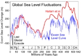
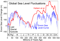 Sea level changes over geologic time. The graph on the right illustrates two recent interpretations of sea level changes during the Phanerozoic
. Today's date is on the far left side, labeled N for Neogene
.
The blue spikes near date zero represent the sea level changes associated with the most recent glacial period
, which reached its maximum extent about 20,000 years Before Present
(BP). During this glaciation event, the world's sea level was about 320 feet (98 meters) lower than today, due to the large amount of sea water
that had evaporated and been deposited as snow
and ice
in Northern Hemisphere
glacier
s. When the world's sea level was at this "low stand", former sea bed sediments were subjected to subaerial
weathering (erosion
by rain, frost, rivers, etc.) and a new shoreline was established at the new level, sometimes miles basinward of the former shoreline if the sea floor was shallowly inclined.
Today, sea level is at a relative "high stand" within the Quaternary glacial cycles because of rapid end-Pleistocene
and early-Holocene
deglaciation. The ancient shoreline of the last glacial period is now under approximately 390 feet (120 meters) of water. Although there is debate among earth scientists whether we are currently experiencing a "high stand" it is generally accepted that the eustatic sea level is rising.
In the distant past, sea level has been significantly higher than today. During the Cretaceous
(labeled K on the graph), sea level was so high that a seaway
extended across the center of North America
from Texas
to the Arctic Ocean
.
These alternating high and low sea level stands repeat at several time scales. The smallest of these cycles is approximately 20,000 years, and corresponds to the rate of precession of the Earth
's rotational axis (see Milankovitch cycles
) and are commonly referred to as '5th order' cycles. The next larger cycle ('4th order') is about 40,000 years and approximately matches the rate at which the Earth's inclination to the Sun
varies (again explained by Milankovitch). The next larger cycle ('3rd order') is about 110,000 years and corresponds to the rate at which the Earth's orbit oscillates from elliptical to circular. Lower order cycles are recognized, which seem to result from plate tectonic events like the opening of new ocean basins by splitting continental masses.
Hundreds of similar glacial cycles have occurred throughout the Earth's history
. The earth scientists who study the positions of coastal sediment deposits through time ("sequence stratigraphers") have noted dozens of similar basinward shifts of shorelines associated with a later recovery. The largest of these sedimentary cycles can in some cases be correlated around the world with great confidence.
The three controls on stratigraphic architecture and sedimentary cycle development are:
Eustatic sea level is the sea level with reference to a fixed point, the centre of the Earth. Another term used to describe the sea level is the 'Relative Sea Level' which is the one measured with reference to the base level, above which erosion can occur and below which deposition can occur. Both eustatic sea level changes and subsidence rates tend to be longer cycles. Sediment supply is largely thought to be controlled by local climatic conditions and can vary rapidly. These variations in local sediment supply affect the local and relative sea level which causes local sedimentary cycles.
Smaller and localised sedimentary cycles are not related to world wide (eustatic) sea level changes but more to the supply of sediment to the adjacent basins
where these sediments are being supplied. For example when the basinward (oceanward) shift with progradation of shorelines was occurring in the Book Cliffs
area of Utah
the shorelines were receding or transgressing northwards in Wyoming
. These sedimentary cycles are representative of the amount of supply of sediment to the basin. In a transgression
, less sediment is being supplied than the rate of increase in the depth of water, and thus the shoreline migrates landward. In a regression
, if the water depth is decreasing, the shoreline migrates seaward (basinward) and the previous shoreline is eroded. A regression of the shoreline also occurs if more sediment is being supplied than the shoreline can erode, causing the shoreline to migrate seaward. The latter is called progradation.
Geology
Geology is the science comprising the study of solid Earth, the rocks of which it is composed, and the processes by which it evolves. Geology gives insight into the history of the Earth, as it provides the primary evidence for plate tectonics, the evolutionary history of life, and past climates...
that attempts to subdivide and link sediment
Sediment
Sediment is naturally occurring material that is broken down by processes of weathering and erosion, and is subsequently transported by the action of fluids such as wind, water, or ice, and/or by the force of gravity acting on the particle itself....
ary deposits into unconformity
Unconformity
An unconformity is a buried erosion surface separating two rock masses or strata of different ages, indicating that sediment deposition was not continuous. In general, the older layer was exposed to erosion for an interval of time before deposition of the younger, but the term is used to describe...
bound units on a variety of scales and explain these stratigraphic units in terms of variations in sediment supply and variations in the rate of change in accommodation space (often associated with changes in relative sea level). The essence of the method is mapping of strata
Stratum
In geology and related fields, a stratum is a layer of sedimentary rock or soil with internally consistent characteristics that distinguish it from other layers...
based on identification of surfaces which are assumed to represent time lines (e.g. subaerial unconformities, maximum flooding surfaces), and therefore placing stratigraphy in chronostratigraphic
Chronostratigraphy
Chronostratigraphy is the branch of stratigraphy that studies the age of rock strata in relation to time.The ultimate aim of chronostratigraphy is to arrange the sequence of deposition and the time of deposition of all rocks within a geological region, and eventually, the entire geologic record of...
framework. Sequence stratigraphy is a useful alternative to a lithostratigraphic
Lithostratigraphy
Lithostratigraphy is a sub-discipline of stratigraphy, the geological science associated with the study of strata or rock layers. Major focuses include geochronology, comparative geology, and petrology...
approach, which emphasizes similarity of the lithology
Lithology
The lithology of a rock unit is a description of its physical characteristics visible at outcrop, in hand or core samples or with low magnification microscopy, such as colour, texture, grain size, or composition. It may be either a detailed description of these characteristics or be a summary of...
of rock units rather than time significance.
The 'sequence' part of the name refers to cyclic sedimentary deposits
Cyclic sediments
Cyclic sediments are sequences of sedimentary rocks that are characterised by repetitive patterns of different rock types within the sequence. Cyclic sediments can be identified as either autocyclic or allocyclic, and can be hundreds or even thousands of metres thick...
. The term 'stratigraphy
Stratigraphy
Stratigraphy, a branch of geology, studies rock layers and layering . It is primarily used in the study of sedimentary and layered volcanic rocks....
' refers to the geologic knowledge about the processes by which sedimentary deposits form and how those deposits change through time and space on the Earth's surface.
Sequence boundaries
Sequence boundaries are deemed the most significant surfaces. Sequence boundaries are defined as unconformities or their correlative conformities. Multi-story fluvial sandstone packages often infill incised valleys formed by the sea level drop associated with sequence boundaries. The incised valleys of sequence boundaries correlate laterally with interfluves, palaeosols formed on the margins of incised valleys. The valley infills are not genetically related to underlying depositional systems as previous interpretations thought. There are four criteria distinguishing incised valley fills from other types of multi-story sandstone deposits: a widespread correlation with a regional, high relief erosional surface that is more widespread than the erosional bases of individual channels within the valley; faciesFacies
In geology, facies are a body of rock with specified characteristics. Ideally, a facies is a distinctive rock unit that forms under certain conditions of sedimentation, reflecting a particular process or environment....
associations reflect a basinward shift in facies when compared with underlying units; erosional base of the valley removes preceding systems tracts and marine bands producing a time gap, the removed units will be preserved beneath the interfluves; increasing channel fill and fine grained units upwards or changes in the character of the fluvial systems reflecting increasing accommodation space. Sandstone bodies associated with incised valleys are good hydrocarbon reservoirs. There have been problems in the correlation and distribution of these bodies. Sequence stratigraphic principles and identification of significant surfaces have resolved some issues.
Parasequence boundaries
Lesser importance is attached to parasequence boundaries, however, there is a suggestion that flooding surfaces representing parasequence boundaries may be more laterally extensive leaving more evidence than sequence boundaries because the coastal plainCoastal plain
A coastal plain is an area of flat, low-lying land adjacent to a seacoast and separated from the interior by other features. One of the world's longest coastal plains is located in eastern South America. The southwestern coastal plain of North America is notable for its species diversity...
has a lower gradient than the inner continental shelf
Continental shelf
The continental shelf is the extended perimeter of each continent and associated coastal plain. Much of the shelf was exposed during glacial periods, but is now submerged under relatively shallow seas and gulfs, and was similarly submerged during other interglacial periods. The continental margin,...
. Parasequence boundaries may be distinguished by differences in physical and chemical properties across the surface such as; formation water salinity, hydrocarbon properties, porosity, compressional velocities and mineralogy. Parasequence boundaries may not form a barrier to hydrocarbon accumulation but may inhibit vertical reservoir communication. After production begins the parasequences act as separate drainage units with the flooding surfaces, which are overlain by shales or carbonate-cemented horizons, forming a barrier to vertical reservoir communications. Sequence stratigraphic principles have optimized production potential once reservoir scale architecture is identified and separate drainage units identified.
Parasequences and stacking patterns
A parasequence is a relatively conformable, genetically related succession of beds and bedsets bounded by marine flooding surfaces and their correlative surfaces. The flooding surfaces bounding parasequences are not of the same scale as the regional transgressive surface that is associated with a sequence boundary.The parasequences are the separated into stacking patterns:
- AggradationAggradationAggradation is the term used in geology for the increase in land elevation due to the deposition of sediment. Aggradation occurs in areas in which the supply of sediment is greater than the amount of material that the system is able to transport...
al - ProgradationProgradationIn sedimentary geology and geomorphology, the term progradation refers to the growth of a river delta farther out into the sea over time. This occurs when the mass balance of sediment into the delta is such that the volume of incoming sediment is greater than the volume of the delta that is lost...
al - Retrogradational
Each stacking pattern will give different information on the behaviour of accommodation space, a major control of which is relative level. So a rapidly progradational pattern will be indicative of falling sea level, rapidly retrogradational is evidence for rapidly transgressing sea level and aggradational will be indicative of gently rising sea level.
Sea level through geologic time
Phanerozoic
The Phanerozoic Eon is the current eon in the geologic timescale, and the one during which abundant animal life has existed. It covers roughly 542 million years and goes back to the time when diverse hard-shelled animals first appeared...
. Today's date is on the far left side, labeled N for Neogene
Neogene
The Neogene is a geologic period and system in the International Commission on Stratigraphy Geologic Timescale starting 23.03 ± 0.05 million years ago and ending 2.588 million years ago...
.
The blue spikes near date zero represent the sea level changes associated with the most recent glacial period
Wisconsin glaciation
The last glacial period was the most recent glacial period within the current ice age occurring during the last years of the Pleistocene, from approximately 110,000 to 10,000 years ago....
, which reached its maximum extent about 20,000 years Before Present
Before Present
Before Present years is a time scale used in archaeology, geology, and other scientific disciplines to specify when events in the past occurred. Because the "present" time changes, standard practice is to use AD 1950 as the origin of the age scale, reflecting the fact that radiocarbon...
(BP). During this glaciation event, the world's sea level was about 320 feet (98 meters) lower than today, due to the large amount of sea water
Seawater
Seawater is water from a sea or ocean. On average, seawater in the world's oceans has a salinity of about 3.5% . This means that every kilogram of seawater has approximately of dissolved salts . The average density of seawater at the ocean surface is 1.025 g/ml...
that had evaporated and been deposited as snow
Snow
Snow is a form of precipitation within the Earth's atmosphere in the form of crystalline water ice, consisting of a multitude of snowflakes that fall from clouds. Since snow is composed of small ice particles, it is a granular material. It has an open and therefore soft structure, unless packed by...
and ice
Ice
Ice is water frozen into the solid state. Usually ice is the phase known as ice Ih, which is the most abundant of the varying solid phases on the Earth's surface. It can appear transparent or opaque bluish-white color, depending on the presence of impurities or air inclusions...
in Northern Hemisphere
Northern Hemisphere
The Northern Hemisphere is the half of a planet that is north of its equator—the word hemisphere literally means “half sphere”. It is also that half of the celestial sphere north of the celestial equator...
glacier
Glacier
A glacier is a large persistent body of ice that forms where the accumulation of snow exceeds its ablation over many years, often centuries. At least 0.1 km² in area and 50 m thick, but often much larger, a glacier slowly deforms and flows due to stresses induced by its weight...
s. When the world's sea level was at this "low stand", former sea bed sediments were subjected to subaerial
Subaerial
The term subaerial is mainly used in geology to describe events or structures that are located at the Earth's surface...
weathering (erosion
Erosion
Erosion is when materials are removed from the surface and changed into something else. It only works by hydraulic actions and transport of solids in the natural environment, and leads to the deposition of these materials elsewhere...
by rain, frost, rivers, etc.) and a new shoreline was established at the new level, sometimes miles basinward of the former shoreline if the sea floor was shallowly inclined.
Today, sea level is at a relative "high stand" within the Quaternary glacial cycles because of rapid end-Pleistocene
Pleistocene
The Pleistocene is the epoch from 2,588,000 to 11,700 years BP that spans the world's recent period of repeated glaciations. The name pleistocene is derived from the Greek and ....
and early-Holocene
Holocene
The Holocene is a geological epoch which began at the end of the Pleistocene and continues to the present. The Holocene is part of the Quaternary period. Its name comes from the Greek words and , meaning "entirely recent"...
deglaciation. The ancient shoreline of the last glacial period is now under approximately 390 feet (120 meters) of water. Although there is debate among earth scientists whether we are currently experiencing a "high stand" it is generally accepted that the eustatic sea level is rising.
In the distant past, sea level has been significantly higher than today. During the Cretaceous
Cretaceous
The Cretaceous , derived from the Latin "creta" , usually abbreviated K for its German translation Kreide , is a geologic period and system from circa to million years ago. In the geologic timescale, the Cretaceous follows the Jurassic period and is followed by the Paleogene period of the...
(labeled K on the graph), sea level was so high that a seaway
Western Interior Seaway
The Western Interior Seaway, also called the Cretaceous Seaway, the Niobraran Sea, and the North American Inland Sea, was a huge inland sea that split the continent of North America into two halves, Laramidia and Appalachia, during most of the mid- and late-Cretaceous Period...
extended across the center of North America
North America
North America is a continent wholly within the Northern Hemisphere and almost wholly within the Western Hemisphere. It is also considered a northern subcontinent of the Americas...
from Texas
Texas
Texas is the second largest U.S. state by both area and population, and the largest state by area in the contiguous United States.The name, based on the Caddo word "Tejas" meaning "friends" or "allies", was applied by the Spanish to the Caddo themselves and to the region of their settlement in...
to the Arctic Ocean
Arctic Ocean
The Arctic Ocean, located in the Northern Hemisphere and mostly in the Arctic north polar region, is the smallest and shallowest of the world's five major oceanic divisions...
.
These alternating high and low sea level stands repeat at several time scales. The smallest of these cycles is approximately 20,000 years, and corresponds to the rate of precession of the Earth
Earth
Earth is the third planet from the Sun, and the densest and fifth-largest of the eight planets in the Solar System. It is also the largest of the Solar System's four terrestrial planets...
's rotational axis (see Milankovitch cycles
Milankovitch cycles
Milankovitch theory describes the collective effects of changes in the Earth's movements upon its climate, named after Serbian civil engineer and mathematician Milutin Milanković, who worked on it during First World War internment...
) and are commonly referred to as '5th order' cycles. The next larger cycle ('4th order') is about 40,000 years and approximately matches the rate at which the Earth's inclination to the Sun
Sun
The Sun is the star at the center of the Solar System. It is almost perfectly spherical and consists of hot plasma interwoven with magnetic fields...
varies (again explained by Milankovitch). The next larger cycle ('3rd order') is about 110,000 years and corresponds to the rate at which the Earth's orbit oscillates from elliptical to circular. Lower order cycles are recognized, which seem to result from plate tectonic events like the opening of new ocean basins by splitting continental masses.
Hundreds of similar glacial cycles have occurred throughout the Earth's history
History of Earth
The history of the Earth describes the most important events and fundamental stages in the development of the planet Earth from its formation 4.578 billion years ago to the present day. Nearly all branches of natural science have contributed to the understanding of the main events of the Earth's...
. The earth scientists who study the positions of coastal sediment deposits through time ("sequence stratigraphers") have noted dozens of similar basinward shifts of shorelines associated with a later recovery. The largest of these sedimentary cycles can in some cases be correlated around the world with great confidence.
The three controls on stratigraphic architecture and sedimentary cycle development are:
- Eustatic sea level changes
- Subsidence rate of the basin
- Sediment supply.
Eustatic sea level is the sea level with reference to a fixed point, the centre of the Earth. Another term used to describe the sea level is the 'Relative Sea Level' which is the one measured with reference to the base level, above which erosion can occur and below which deposition can occur. Both eustatic sea level changes and subsidence rates tend to be longer cycles. Sediment supply is largely thought to be controlled by local climatic conditions and can vary rapidly. These variations in local sediment supply affect the local and relative sea level which causes local sedimentary cycles.
Smaller and localised sedimentary cycles are not related to world wide (eustatic) sea level changes but more to the supply of sediment to the adjacent basins
Sedimentary basin
The term sedimentary basin is used to refer to any geographical feature exhibiting subsidence and consequent infilling by sedimentation. As the sediments are buried, they are subjected to increasing pressure and begin the process of lithification...
where these sediments are being supplied. For example when the basinward (oceanward) shift with progradation of shorelines was occurring in the Book Cliffs
Book Cliffs
The Book Cliffs are a series of mountains and cliffs in western Colorado and eastern Utah, in the western United States. They are so named because many of them have the triangular appearance of a book that has been opened up, then turned on its sides and set to rest on the open sides of the book,...
area of Utah
Utah
Utah is a state in the Western United States. It was the 45th state to join the Union, on January 4, 1896. Approximately 80% of Utah's 2,763,885 people live along the Wasatch Front, centering on Salt Lake City. This leaves vast expanses of the state nearly uninhabited, making the population the...
the shorelines were receding or transgressing northwards in Wyoming
Wyoming
Wyoming is a state in the mountain region of the Western United States. The western two thirds of the state is covered mostly with the mountain ranges and rangelands in the foothills of the Eastern Rocky Mountains, while the eastern third of the state is high elevation prairie known as the High...
. These sedimentary cycles are representative of the amount of supply of sediment to the basin. In a transgression
Transgression (geology)
A marine transgression is a geologic event during which sea level rises relative to the land and the shoreline moves toward higher ground, resulting in flooding. Transgressions can be caused either by the land sinking or the ocean basins filling with water...
, less sediment is being supplied than the rate of increase in the depth of water, and thus the shoreline migrates landward. In a regression
Marine regression
Marine regression is a geological process occurring when areas of submerged seafloor are exposed above the sea level. The opposite event, marine transgression, occurs when flooding from the sea covers previously exposed land....
, if the water depth is decreasing, the shoreline migrates seaward (basinward) and the previous shoreline is eroded. A regression of the shoreline also occurs if more sediment is being supplied than the shoreline can erode, causing the shoreline to migrate seaward. The latter is called progradation.
Economic significance
These events have economic significance because these changes in sea level cause large lateral shifts in the depositional patterns of seafloor sediments. These lateral shifts in deposition create alternating layers of good reservoir quality rock (porous and permeable sands) and poorer-quality mudstones (capable of providing a reservoir "seal" to prevent the leakage of any accumulated hydrocarbons that may have migrated into the sandstones). Hydrocarbon prospectors look for places in the world where porous and permeable sands are overlain by low permeability rocks, and where conditions are right for hydrocarbons to be generated and migrate into these "traps".External links
- A chart of sea level for the past 140,000 years (The different orders of cyclicity can be seen as higher frequency chatter on an overall asymmetric cycle. Today's date is on the right side of this chart.)
- USC's Sequence Stratigraphy Web a fairly extensive online education resource
- An Online Guide to Sequence Stratigraphy by the University of Georgia's Stratigraphy Lab.