
Altimeter
Encyclopedia
Altitude
Altitude or height is defined based on the context in which it is used . As a general definition, altitude is a distance measurement, usually in the vertical or "up" direction, between a reference datum and a point or object. The reference datum also often varies according to the context...
of an object above a fixed level. The measurement of altitude is called altimetry, which is related to the term bathymetry
Bathymetry
Bathymetry is the study of underwater depth of lake or ocean floors. In other words, bathymetry is the underwater equivalent to hypsometry. The name comes from Greek βαθύς , "deep", and μέτρον , "measure"...
, the measurement of depth underwater.
Pressure altimeter
Aircraft
An aircraft is a vehicle that is able to fly by gaining support from the air, or, in general, the atmosphere of a planet. An aircraft counters the force of gravity by using either static lift or by using the dynamic lift of an airfoil, or in a few cases the downward thrust from jet engines.Although...
, and skydivers use wrist-mounted versions for similar purposes. Hikers and mountain climbers use wrist-mounted or hand-held altimeters, in addition to other navigational tools such as a map, magnetic compass, or GPS receiver.
The calibration of an altimeter is of the form

where c is a constant, T is the absolute temperature, P is the pressure at altitude z, and Po is the pressure at sea level. The constant c depends on the acceleration of gravity and the molar mass of the air.
Use in hiking and climbing
A barometric altimeter, used along with a topographic map, can help to verify one's location. It is more reliable, and often more accurate, than a GPS receiver for measuring altitude; GPS altimeters may be unavailable, for example, when one is deep in a canyon, or may give wildly inaccurate altitudes when all available satellites are near the horizon. Because the barometric pressure changes with the weather, hikers must periodically recalibrate their altimeters when they reach a known altitude, such as a trail junction or peak marked on a topographical map.Use in aircraft
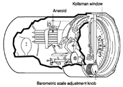
In it, an aneroid barometer measures the atmospheric pressureAtmospheric pressure
Atmospheric pressure is the force per unit area exerted into a surface by the weight of air above that surface in the atmosphere of Earth . In most circumstances atmospheric pressure is closely approximated by the hydrostatic pressure caused by the weight of air above the measurement point...
from a static port
Pitot-static system
A pitot-static system is a system of pressure-sensitive instruments that is most often used in aviation to determine an aircraft's airspeed, Mach number, altitude, and altitude trend. A pitot-static system generally consists of a pitot tube, a static port, and the pitot-static instruments...
outside the aircraft. Air pressure decreases with an increase of altitude—approximately 100 hectopascals
Bar (unit)
The bar is a unit of pressure equal to 100 kilopascals, and roughly equal to the atmospheric pressure on Earth at sea level. Other units derived from the bar are the megabar , kilobar , decibar , centibar , and millibar...
per 800 meters or one inch of mercury
Inch of mercury
Inches of mercury, ' is a unit of measurement for pressure. It is still widely used for barometric pressure in weather reports, refrigeration and aviation in the United States, but is seldom used elsewhere....
per 1000 feet near sea level
Sea level
Mean sea level is a measure of the average height of the ocean's surface ; used as a standard in reckoning land elevation...
.
The aneroid altimeter is calibrated to show the pressure directly as an altitude above mean sea level, in accordance with a mathematical model defined by the International Standard Atmosphere
International Standard Atmosphere
The International Standard Atmosphere is an atmospheric model of how the pressure, temperature, density, and viscosity of the Earth's atmosphere change over a wide range of altitudes. It has been established to provide a common reference for temperature and pressure and consists of tables of...
(ISA). Older aircraft used a simple aneroid barometer where the needle made less than one revolution around the face from zero to full scale. This design evolved to the drum-type altimeter, where each revolution of a single needle accounted for 1,000 feet, and with thousand foot increments recorded on a numerical odometer
Odometer
An odometer or odograph is an instrument that indicates distance traveled by a vehicle, such as a bicycle or automobile. The device may be electronic, mechanical, or a combination of the two. The word derives from the Greek words hodós and métron...
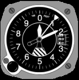
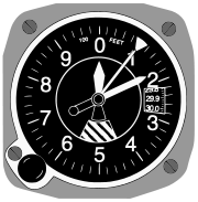
-type drum. To determine altitude, a pilot first had to read the drum to get the thousands of feet, then look at the needle for the hundreds of feet. Modern aircraft use a "sensitive altimeter," which has a primary needle, and one or more secondary needles that show the number of revolutions, similar to a clock face
Clock face
A clock face is the part of an analog clock that displays the time through the use of a fixed numbered dial or dials and moving hands. In its most basic form, recognized universally throughout the world, the dial is numbered 1–12 indicating the hours in a 12-hour cycle, and a short hour hand...
. In other words, each needle points to a different digit of the current altitude measurement. On a sensitive altimeter, the sea level reference pressure can be adjusted by a setting knob. The reference pressure, in inches of mercury
Inch of mercury
Inches of mercury, ' is a unit of measurement for pressure. It is still widely used for barometric pressure in weather reports, refrigeration and aviation in the United States, but is seldom used elsewhere....
in Canada
Canada
Canada is a North American country consisting of ten provinces and three territories. Located in the northern part of the continent, it extends from the Atlantic Ocean in the east to the Pacific Ocean in the west, and northward into the Arctic Ocean...
and the US
United States
The United States of America is a federal constitutional republic comprising fifty states and a federal district...
and hectopascals (previously millibars
Pascal (unit)
The pascal is the SI derived unit of pressure, internal pressure, stress, Young's modulus and tensile strength, named after the French mathematician, physicist, inventor, writer, and philosopher Blaise Pascal. It is a measure of force per unit area, defined as one newton per square metre...
) elsewhere, is displayed in the small Kollsman
Paul Kollsman
Paul Kollsman was an American inventor. He invented barometers and instruments for instrument flight in airplanes....
window, on the face of the aircraft altimeter. This is necessary, since sea level reference atmospheric pressure at a given location varies over time with temperature and the movement of pressure system
Pressure system
A pressure system is a region of the Earth's atmosphere where air pressure is a relative peak or lull in the sea level pressure distribution. The surface pressure at sea level varies minimally, with the lowest value measured and the highest recorded...
s in the atmosphere.
Aviation
Aviation is the design, development, production, operation, and use of aircraft, especially heavier-than-air aircraft. Aviation is derived from avis, the Latin word for bird.-History:...
terminology, the regional or local air pressure at mean sea level (MSL) is called the QNH
QNH
QNH is one of the many Q codes. It is defined as, "barometric pressure adjusted to sea level." It is a pressure setting used by pilots, air traffic control , and low frequency weather beacons to refer to the barometric setting which, when set on an aircraft's altimeter, will cause the altimeter to...
or "altimeter setting", and the pressure that will calibrate the altimeter to show the height above ground at a given airfield
Airport
An airport is a location where aircraft such as fixed-wing aircraft, helicopters, and blimps take off and land. Aircraft may be stored or maintained at an airport...
is called the QFE of the field. An altimeter cannot, however, be adjusted for variations in air temperature. Differences in temperature from the ISA model will, therefore, cause errors in indicated altitude.
Sonic altimeter
In 1931, the US Army Air Corps and General Electric tested a sonic altimeter for aircraft, which was considered more reliable and accurate than one that relied on air pressure, when heavy fog or rain was present. The new altimeter used a series of high-pitched sounds like a bat to measure the distance from the aircraft to the surface, which on return to the aircraft was converted to feet shown on a gauge inside the aircraft cockpit.Radar altimeter
A radar altimeterRadar altimeter
A radar altimeter, radio altimeter, low range radio altimeter or simply RA measures altitude above the terrain presently beneath an aircraft or spacecraft...
measures altitude more directly, using the time taken for a radio signal to reflect from the surface back to the aircraft. The radar altimeter is used to measure height above ground level during landing in commercial and military aircraft. Radar altimeters are also a component of terrain avoidance warning systems, warning the pilot if the aircraft is flying too low, or if there is rising terrain ahead. Radar altimeter technology is also used in terrain-following radar
Terrain-following radar
Terrain-following radar is an aerospace technology that allows a very-low-flying aircraft to automatically maintain a relatively constant altitude above ground level. It is sometimes referred-to as ground hugging or terrain hugging flight...
allowing fighter aircraft
Fighter aircraft
A fighter aircraft is a military aircraft designed primarily for air-to-air combat with other aircraft, as opposed to a bomber, which is designed primarily to attack ground targets...
to fly at very low altitude.
Global Positioning System
Global Positioning SystemGlobal Positioning System
The Global Positioning System is a space-based global navigation satellite system that provides location and time information in all weather, anywhere on or near the Earth, where there is an unobstructed line of sight to four or more GPS satellites...
(GPS) receivers can also determine altitude by trilateration
Trilateration
In geometry, trilateration is the process of determinating absolute or relative locations of points by measurement of distances, using the geometry of circles, spheres or triangles. In addition to its interest as a geometric problem, trilateration does have practical applications in surveying and...
with four or more satellite
Satellite
In the context of spaceflight, a satellite is an object which has been placed into orbit by human endeavour. Such objects are sometimes called artificial satellites to distinguish them from natural satellites such as the Moon....
s. In aircraft, altitude determined using autonomous GPS is not precise or accurate enough to supersede the pressure altimeter without using some method of augmentation
GNSS Augmentation
Augmentation of a global navigation satellite system is a method of improving the navigation system's attributes, such as accuracy, reliability, and availability, through the integration of external information into the calculation process. There are many such systems in place and they are...
. In hiking and climbing, it is not uncommon to find that the altitude measured by GPS is off by as much as a thousand meters, if all the available satellites happen to be close to the horizon.
Other modes of transport
The altimeter is an instrument optional in off-road vehicles to aid in navigation. Some high-performance luxury cars that were never intended to leave paved roads, such as the DuesenbergDuesenberg
Duesenberg was an Auburn, Indiana based American luxury automobile company active in various forms from 1913 to 1937, most famous for its high-quality passenger cars and record-breaking racing cars.-History:...
in the 1930s, have also been equipped with altimeters.
Hikers and mountaineer
Mountaineering
Mountaineering or mountain climbing is the sport, hobby or profession of hiking, skiing, and climbing mountains. While mountaineering began as attempts to reach the highest point of unclimbed mountains it has branched into specialisations that address different aspects of the mountain and consists...
s use hand-held or wrist-mounted barometric altimeters, as do skydivers
Parachuting
Parachuting, also known as skydiving, is the action of exiting an aircraft and returning to earth with the aid of a parachute. It may or may not involve a certain amount of free-fall, a time during which the parachute has not been deployed and the body gradually accelerates to terminal...
.
Diesel submarines have altimeters installed on them to monitor vacuum being pulled in the event that the snorkel closes while the diesels are running and, as a consequence, sucking the air out of the boat.
Satellites
Radar
Radar is an object-detection system which uses radio waves to determine the range, altitude, direction, or speed of objects. It can be used to detect aircraft, ships, spacecraft, guided missiles, motor vehicles, weather formations, and terrain. The radar dish or antenna transmits pulses of radio...
altimeters to measure height from a spacecraft
Spacecraft
A spacecraft or spaceship is a craft or machine designed for spaceflight. Spacecraft are used for a variety of purposes, including communications, earth observation, meteorology, navigation, planetary exploration and transportation of humans and cargo....
. That measurement, coupled with orbit
Orbit
In physics, an orbit is the gravitationally curved path of an object around a point in space, for example the orbit of a planet around the center of a star system, such as the Solar System...
al elements (possibly augmented by GPS), enables determination of the terrain
Terrain
Terrain, or land relief, is the vertical and horizontal dimension of land surface. When relief is described underwater, the term bathymetry is used...
. The two different wavelengths of radio waves used permit the altimeter to automatically correct for varying delays in the ionosphere
Ionosphere
The ionosphere is a part of the upper atmosphere, comprising portions of the mesosphere, thermosphere and exosphere, distinguished because it is ionized by solar radiation. It plays an important part in atmospheric electricity and forms the inner edge of the magnetosphere...
.
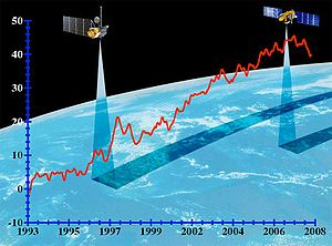
Spaceborne radar altimeters have proven to be superb tools for mapping ocean-surface topography, the hills and valleys of the sea surface. These instruments send a microwave pulse to the ocean’s surface and time how long it takes to return. A microwave radiometer
Microwave radiometer
A microwave radiometer is a radiometer that measures energy emitted at sub-millimetre-to-centimetre wavelengths known as microwaves. Their primary application has been onboard spacecraft measuring atmospheric and terrestrial radiation, and they are mostly used for meteorological or oceanographic...
corrects any delay that may be caused by water vapor
Water vapor
Water vapor or water vapour , also aqueous vapor, is the gas phase of water. It is one state of water within the hydrosphere. Water vapor can be produced from the evaporation or boiling of liquid water or from the sublimation of ice. Under typical atmospheric conditions, water vapor is continuously...
in the atmosphere
Atmosphere
An atmosphere is a layer of gases that may surround a material body of sufficient mass, and that is held in place by the gravity of the body. An atmosphere may be retained for a longer duration, if the gravity is high and the atmosphere's temperature is low...
. Other corrections are also required to account for the influence of electrons in the ionosphere
Ionosphere
The ionosphere is a part of the upper atmosphere, comprising portions of the mesosphere, thermosphere and exosphere, distinguished because it is ionized by solar radiation. It plays an important part in atmospheric electricity and forms the inner edge of the magnetosphere...
and the dry air mass of the atmosphere. Combining these data with the precise location of the spacecraft makes it possible to determine sea-surface height to within a few centimetres (about one inch). The strength and shape of the returning signal also provides information on wind speed and the height of ocean waves. These data are used in ocean models to calculate the speed and direction of ocean current
Ocean current
An ocean current is a continuous, directed movement of ocean water generated by the forces acting upon this mean flow, such as breaking waves, wind, Coriolis effect, cabbeling, temperature and salinity differences and tides caused by the gravitational pull of the Moon and the Sun...
s and the amount and location of heat stored in the ocean, which, in turn, reveals global climate variations.
See also
- Acronyms and abbreviations in avionicsAcronyms and abbreviations in avionics-A:*ACARS: Aircraft Communications Addressing and Reporting System.*ACAS: Airborne Collision Avoidance System.*ACP: Audio Control Panel.*ACS: Audio Control System.*ADAHRS: Air Data and Attitude Heading Reference System.*ADC: Air Data Computer....
- Flight instrumentsFlight instrumentsFlight instruments are the instruments in the cockpit of an aircraft that provide the pilot with information about the flight situation of that aircraft, such as height, speed and altitude...
- Flight levelFlight levelA Flight Level is a standard nominal altitude of an aircraft, in hundreds of feet. This altitude is calculated from the International standard pressure datum of 1013.25 hPa , the average sea-level pressure, and therefore is not necessarily the same as the aircraft's true altitude either...
- seasatSeasatSEASAT was the first Earth-orbiting satellite designed for remote sensing of the Earth's oceans and had on board the first spaceborne synthetic aperture radar . The mission was designed to demonstrate the feasibility of global satellite monitoring of oceanographic phenomena and to help determine...
, TOPEX/PoseidonTOPEX/PoseidonLaunched in 1992, TOPEX/Poseidon was a joint satellite mission between NASA, the U.S. space agency, and CNES, the French space agency, to map ocean surface topography. The first major oceanographic research vessel to sail into space, TOPEX/Poseidon helped revolutionize oceanography by proving the...
are satellites that deployed extremely accurate altimeters - United Airlines Flight 389United Airlines Flight 389United Airlines Flight 389 was a scheduled flight from LaGuardia Airport, New York City, New York, to O'Hare International Airport, Chicago, Illinois. On August 16, 1965, at approximately 21:21 EST, the Boeing 727 crashed into Lake Michigan east of Fort Sheridan, near Lake Forest, while descending...
, an accident attributed to misreading of an altimeter - Turkish Airlines Flight 1951Turkish Airlines Flight 1951Turkish Airlines Flight 1951 was a passenger flight which crashed during landing to Amsterdam Schiphol Airport, Netherlands, on 25 February 2009, killing nine passengers and crew including all three pilots....
, an accident attributed to a malfunctioning radio altimeter - Jason-1, Ocean Surface Topography Mission/Jason-2 are current satellite missions that use altimeters to measure sea surface height
External links
- MS5561C Micro Altimeter for GPS, 1m resolution
- History of the Kollsman altimeter
- A Flash 8 based simulator for altimeter errors caused by variations in temperature and pressure
- The use of altimeters in height measurement - for hillwalkers
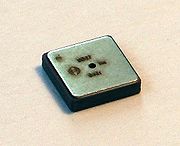
- Compact digital pressure sensor for altimeters
- Early use of barometers on surveys
- The altimeter and the types of altitude
- Evolution of the Modern Altimeter - Flight archive