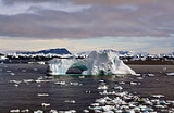
All Topics  
Iceberg

 
Iceberg

   Email Print
   Bookmark   Link


Iceberg


An iceberg is a large piece of freshwater ice
Ice

Ice is a solid phases of matter, usually crystalline solid, of a non-metallic substance that is liquid or gas at room temperature, such as ammonia ice or methane ice....
 that has broken off from a snow-formed glacier
Glacier

A glacier is a large, slow-moving mass of ice, formed from compacted layers of snow, that slowly deforms and flows in response to gravity and high pressure....
 or ice shelf
Ice shelf

An ice shelf is a thick, floating platform of ice that forms where a glacier or ice sheet flows down to a coastline and onto the ocean surface....
 and is floating in open water. It may subsequently become frozen into pack ice or come to rest on the seabed in shallower water, causing ice scour
Ice scour

Ice scour is a geological term for long, narrow ditches in a seabed, created by the collision of fast ice and pack ice and the grounding of icebergs....
.

word iceberg is a partial loan translation from Dutch
Dutch language

Dutch is a West Germanic languages spoken by over 22 million people as a first language, and about 5 million people as a second language."1% of the EU population claims to speak Dutch well enough in order to have a conversation." Outside the European Union the number of second language speakers of Dutch is very small. Most native...
 ijsberg, literally meaning ice mountain, cognate to Danish
Danish language

Danish is one of the North Germanic languages , a sub-group of the Germanic languages branch of the Indo-European languages. It is spoken by around 6 million people, mainly in Denmark; the language is also used by the 50,000 Danes in the northern parts of Schleswig-Holstein in Germany where it holds the status of minority language....
 Isbjerg, German
German language

German is a West Germanic languages, thus related to and classified alongside English language and Dutch language. It is one of the world's world language and the most widely spoken mother tongue in the European Union....
 Eisberg, Low Saxon Iesbarg and Swedish
Swedish language

Swedish is a North Germanic languages language, spoken by around 10 million people, predominantly in Sweden and parts of Finland, especially along the coast and on the ?land islands....
 Isberg.


Discussion
Ask a question about 'Iceberg'
Start a new discussion about 'Iceberg'
Answer questions from other users
Full Discussion Forum


Encyclopedia


An iceberg is a large piece of freshwater ice
Ice

Ice is a solid phases of matter, usually crystalline solid, of a non-metallic substance that is liquid or gas at room temperature, such as ammonia ice or methane ice....
 that has broken off from a snow-formed glacier
Glacier

A glacier is a large, slow-moving mass of ice, formed from compacted layers of snow, that slowly deforms and flows in response to gravity and high pressure....
 or ice shelf
Ice shelf

An ice shelf is a thick, floating platform of ice that forms where a glacier or ice sheet flows down to a coastline and onto the ocean surface....
 and is floating in open water. It may subsequently become frozen into pack ice or come to rest on the seabed in shallower water, causing ice scour
Ice scour

Ice scour is a geological term for long, narrow ditches in a seabed, created by the collision of fast ice and pack ice and the grounding of icebergs....
.

Etymology

The word iceberg is a partial loan translation from Dutch
Dutch language

Dutch is a West Germanic languages spoken by over 22 million people as a first language, and about 5 million people as a second language."1% of the EU population claims to speak Dutch well enough in order to have a conversation." Outside the European Union the number of second language speakers of Dutch is very small. Most native...
 ijsberg, literally meaning ice mountain, cognate to Danish
Danish language

Danish is one of the North Germanic languages , a sub-group of the Germanic languages branch of the Indo-European languages. It is spoken by around 6 million people, mainly in Denmark; the language is also used by the 50,000 Danes in the northern parts of Schleswig-Holstein in Germany where it holds the status of minority language....
 Isbjerg, German
German language

German is a West Germanic languages, thus related to and classified alongside English language and Dutch language. It is one of the world's world language and the most widely spoken mother tongue in the European Union....
 Eisberg, Low Saxon Iesbarg and Swedish
Swedish language

Swedish is a North Germanic languages language, spoken by around 10 million people, predominantly in Sweden and parts of Finland, especially along the coast and on the ?land islands....
 Isberg. Icebergs are often referred to simply as "bergs".

Overview

Because the density
Density

The density of a material is defined as its mass per unit volume. The symbol of density is ....
 of pure ice is about 920 kg/m³, and that of sea water about 1025 kg/m³, typically only one-tenth of the volume of an iceberg is above water. The shape of the under water portion can be difficult to judge by looking at the portion above the surface. This has led to the expression "tip of the iceberg", generally applied to a problem or difficulty, meaning that the visible trouble is only a small manifestation of a larger problem.

Icebergs generally range from 1 to 75 meters (3–250 ft) above sea level and weigh 100,000 to 200 000 tons. The tallest known iceberg in the North Atlantic was 168 meters (550 ft) above sea level, making it the height of a 55-story building. Despite their size, the icebergs of Newfoundland move an average of 17 kilometers a day (10 mi). These icebergs originate from the glaciers of western Greenland
Greenland

Greenland is a member country of the Kingdom of Denmark located between the Arctic Ocean and Atlantic Oceans, east of the Canadian Arctic Archipelago....
, and may have an interior temperature of -15 to -20°C
Celsius

Celsius is a temperature scale that is named after the Swedish astronomer Anders Celsius , who developed a similar temperature scale two years before his death....
 (5 to -4 °F
Fahrenheit

Fahrenheit is a temperature scale named after the physicist Daniel Gabriel Fahrenheit , who proposed it in 1724. Today, the scale has largely been replaced by the Celsius scale; it is still in use for non-scientific purposes in the United States and a few other countries such as Belize....
).

Though usually confined by winds and currents to move close to the coast, the largest icebergs recorded are calved, or broken off from, the Ross Ice Shelf
Ross Ice Shelf

File:Map-antarctica-ross-ice-shelf-red-x.pngThe Ross Ice Shelf is the largest ice shelf of Antarctica . It is several hundred meters thick. The nearly vertical ice front to the open sea is more than 600 km long, and between 15 and 50 meters high above the water surface....
 of Antarctica
Antarctica

Antarctica is Earth's southernmost continent, overlying the South Pole. It is situated in the Antarctica of the southern hemisphere, almost entirely south of the Antarctic Circle, and is surrounded by the Southern Ocean....
. Iceberg B-15
Iceberg B-15

Iceberg B-15 was the world's largest recorded iceberg. With an area of over 11,000 km?, it was larger than the island of Jamaica....
, photographed by satellite in 2000, measured 295 km long and 37 km wide (183-23 mi), with a surface area of 11,000 km² (4,250 mi²). The mass was estimated around three billion tonnes.

When an iceberg melts, it makes a fizzing sound called "Bergie Seltzer
Seltzer

Seltzer may refer to:*Carbonated water, also known as seltzer, plain water into which carbon dioxide gas has been dissolved*Seltzer, Pennsylvania, census-designated place in Schuylkill County, Pennsylvania, United States...
." This sound is made when compressed air bubbles trapped in the iceberg pop. The bubbles come from air trapped in snow layers that later become glacial ice.

Ice campers who camp on top of flat or hollowed icebergs are known as icebergers.

Classification


Size

Iceberg
Names for various sizes of iceberg are not universal, but usually follow a similar pattern. The size classification in the table below is used by the International Ice Patrol
International Ice Patrol

Since 1914 the International Ice Patrol has been monitoring the presence of icebergs in the northern Atlantic Ocean and reports their movements for safety purposes....
:
Size Category Height Length
Growler Less than 1 meters (3 ft) Less than 5 meters (16 ft)
Bergy Bit 1–5 meters (3–16 ft) 5–15 meters(16–50 ft)
Small5–15 meters(16–50 ft)15–60 meters(50–200 ft)
Medium15–45 meters(50–150 ft)60–120 meters(200–400 ft)
Large45–75 meters(150–250 ft)120–200 meters(400–660 ft)
Very LargeOver 75 meters(250 ft)Over 200 meters(660 ft)


Shape

In addition to the above size classification, there is also a type of classification based on shape. The two basic types of iceberg forms are tabular and non-tabular. Tabular icebergs have steep sides and a flat top, much like a plateau
Plateau

In geology and earth science, a plateau, also called a high plateau or tableland, is an area of highland , usually consisting of relatively flat terrain....
, with a length-to-height ratio of more than 5:1. Non-tabular icebergs have different shapes, and include:* Dome: An iceberg with a rounded top.
  • Pinnacle: An iceberg with one or more spire
    Spire

    A spire is a tapering conical or pyramidal structure on the top of a building, particularly a church tower. Etymologically, the word is derived from Anglo-Saxon language, so it is related to "spear," rather than the Romance languages and "spirit."...
    s.
  • Wedge: An iceberg with a steep edge on one side and a slope on the opposite side.
  • Dry-Dock: An iceberg that has eroded
    Erosion

    For morphological image processing operations, see Erosion 'For use of in dermatopathology, see Erosion Erosion is the removal of solids in the natural environment....
     to form a slot or channel
    Channel (geography)

    In physical geography, a channel is the physical confine of a river, slough or ocean strait consisting of a bed and banks.A channel is also the natural or man-made deeper course through a reef, bar , bay, or any shallow body of water....
    .
  • Blocky: An iceberg with steep, vertical sides and a flat top. It differs from tabular icebergs in that its shape is more like a block than a flat sheet.


History

In the 20th century, several scientific bodies were established to study and monitor the icebergs. The International Ice Patrol
International Ice Patrol

Since 1914 the International Ice Patrol has been monitoring the presence of icebergs in the northern Atlantic Ocean and reports their movements for safety purposes....
, formed in 1914 in response to the Titanic
RMS Titanic

The Royal Mail Ship Titanic was an Olympic class ocean liner superliner owned by the White Star Line and built at the Harland and Wolff shipyard in Belfast, United Kingdom of Great Britain and Ireland....
 disaster, monitors iceberg dangers near the Grand Banks
Grand Banks

The Grand Banks of Newfoundland are a group of underwater plateaus southeast of Newfoundland on the North American continental shelf. These areas are relatively shallow, ranging from 80 to 330 feet in depth....
 of Newfoundland and provide the "limits of all known ice" in that vicinity to the maritime community.

A chunk of Antarctic ice about seven times the size of Manhattan
Manhattan

Manhattan is one of the five borough of New York City, located primarily on Manhattan Island at the mouth of the Hudson River.With a United States Census of 1,620,867 living in a land area of 22.96 square miles , Manhattan, coextensive with New York County, is the most population density county in the United States, w...
 suddenly collapsed, putting an even greater portion of glacial ice at risk and an ice shelf about the size of Connecticut
Connecticut

Connecticut is a U.S. state located in the New England region of the northeastern United States. The state borders New York to the west and south , Massachusetts to the north, and Rhode Island to the east....
 was "hanging by a thread" as of March 25 2008.

Monitoring

Icebergs are monitored worldwide by the U.S. National Ice Center
National Ice Center

The National Ice Center is a tri-agency operational center whose mission is to provide world-wide navigational ice analyses for the United States Armed Forces of the United States, allied nations, and Government of the United States agencies....
 (NIC), established in 1995, which produces analyses and forecasts of Arctic
Arctic

The Arctic is the region around the Earth's North Pole, opposite the Antarctica region around the South Pole. The Arctic includes the Arctic Ocean and parts of Canada, Greenland , Russia, the United States , Iceland, Norway, Sweden and Finland....
, Antarctic
Antarctic Circle

The Antarctic Circle is one of the five major circle of latitude that mark maps of the Earth. As of 2000, it lies at latitude 66degree 33' 39? south of the equator....
, Great Lakes
Great Lakes

The St. Lawrence River Great Lakes are a chain of fresh water lakes located in eastern North America, on the Canada ? United States border. Consisting of Lakes Lake Superior, Lake Michigan, Lake Huron, Lake Erie, and Lake Ontario, they form the largest group of freshwater lakes on Earth....
 and Chesapeake Bay
Chesapeake Bay

The Chesapeake Bay is the largest estuary in the United States. It lies off the Atlantic Ocean, surrounded by Maryland and Virginia. The Chesapeake Bay's drainage basin covers in the District of Columbia and parts of six states: New York, Pennsylvania, Delaware, Maryland, Virginia, and West Virginia....
 ice conditions. More than 95% of the data used in its sea ice analyses are derived from the remote sensors on polar-orbiting satellites that survey these remote regions of the Earth.

The NIC is the only organization that names and tracks all Antarctic Icebergs. It assigns each iceberg larger than 10 nautical mile
Nautical mile

A nautical mile or sea mile is a unit of length. It corresponds approximately to one minute of arc of latitude along any meridian .It is a non-International System of Units unit used especially by navigators in the shipping and aviation industries....
s (18 km) along at least one axis a name composed of a letter indicating its point of origin and a running number. The letters used are as follows:
  • Alongitude
    Longitude

    Longitude , symbolized by the Greek character lambda , is the geographic coordinate most commonly used in cartography and global navigation for east-west measurement....
     0° to 90° W (Bellingshausen Sea
    Bellingshausen Sea

    The Bellingshausen Sea is an area along the west side of the Antarctic Peninsula, between Alexander Island and Thurston Island. It takes its name from Admiral Fabian Gottlieb von Bellingshausen , who explored in the area in 1821....
    , Weddell Sea
    Weddell Sea

    The Weddell Sea is part of the Southern Ocean. Its land boundaries are defined by the bay formed from the coasts of Coats Land and the Antarctic Peninsula....
    )
  • B – longitude 90° W to 180° (Amundsen Sea
    Amundsen Sea

    The Amundsen Sea is an arm of the Southern Ocean off Marie Byrd Land in western Antarctica. It is bounded by Thurston Island to the east and Cape Dart to the west....
    , Eastern Ross Sea
    Ross Sea

    The Ross Sea is a deep Headlands and bays of the Southern Ocean in Antarctica between Victoria Land and Marie Byrd Land. It was discovered by James Clark Ross in 1841....
    )
  • C – longitude 90° E to 180° (Western Ross Sea, Wilkes Land
    Wilkes Land

    Wilkes Land is a large district of land in eastern Antarctica, formally claimed by Australia as part of the Australian Antarctic Territory, though the validity of this claim has been placed in abeyance for the period of the operation of the Antarctic Treaty, to which Australia is a signatory....
    )
  • D – longitude 0° to 90° E (Amery Ice Shelf
    Amery Ice Shelf

    The Amery Ice Shelf is a broad ice shelf at the head of Prydz Bay between the Lars Christensen Coast and Ingrid Christensen Coast. It is part of Mac Robertson Land....
    , Eastern Weddell Sea)


Iceberg B15, which calved from the Ross Ice Shelf
Ross Ice Shelf

File:Map-antarctica-ross-ice-shelf-red-x.pngThe Ross Ice Shelf is the largest ice shelf of Antarctica . It is several hundred meters thick. The nearly vertical ice front to the open sea is more than 600 km long, and between 15 and 50 meters high above the water surface....
 in 2000 and initially had an area of 11,000 km², was the largest iceberg ever recorded. It broke apart in November 2002. The largest remaining piece of it, Iceberg B-15A, with an area of 3,000 km², was still the largest iceberg on Earth until it ran aground and split into several pieces October 27 2005. It has been determined that the cause of the breakup was an ocean swell generated by an Alaska
Alaska

Alaska is the largest U.S. state of the United States by area; it is situated in the northwest extremity of the North American continent, with Canada to the east, the Arctic Ocean to the north, and the Pacific Ocean to the west and south, with Russia further west across the Bering Strait....
n storm 6 days earlier and 13,500 kilometers (8,370 miles) away.

Technology history

Titanic Iceberg
There was no system in place before 1912 to track icebergs to guard against ship collisions. The sinking of the RMS Titanic
RMS Titanic

The Royal Mail Ship Titanic was an Olympic class ocean liner superliner owned by the White Star Line and built at the Harland and Wolff shipyard in Belfast, United Kingdom of Great Britain and Ireland....
, which caused the death of more than 1,500 of its 2,223 passengers, created the demand for a system to observe icebergs. For the remainder of the ice season of that year, the United States Navy
United States Navy

The United States Navy is the navy of the United States Armed Forces. It is one of the seven uniformed services of the United States. The U.S. Navy currently has approximately 331,682 personnel on active duty as of 31 December 2008 and 124,000 in the United States Navy Reserve....
 patrolled the waters and monitored ice flow. In November 1913, the International Conference on the Safety of Life at Sea met in London
London

London is the capital of both England and the United Kingdom, and the most populous municipality in the European Union. An important settlement for two millennia, History of London goes back to its founding by the Roman Empire....
 to devise a more permanent system of observing icebergs. Within three months, the participating maritime nations had formed the International Ice Patrol
International Ice Patrol

Since 1914 the International Ice Patrol has been monitoring the presence of icebergs in the northern Atlantic Ocean and reports their movements for safety purposes....
 (IIP). The goal of the IIP was to collect data on meteorology
Meteorology

Meteorology is the interdisciplinary scientific study of the Earth's atmosphere that focuses on weather processes and forecasting . Studies in the field stretch back millennia, though significant progress in meteorology did not occur until the eighteenth century....
 and oceanography
Oceanography

Oceanography , also called oceanology or marine science, is the branch of Earth science that studies the ocean. It covers a wide range of topics, including marine organisms and ecosystem dynamics; ocean currents, waves, and geophysical fluid dynamics; plate tectonics and the geology of the sea floor; and fluxes of various chemi...
 in order to measure currents, iceflow, ocean temperature, and salinity levels. They published their first records in 1921, which allowed for a year-by-year comparison of iceberg movement.

New technologies monitor icebergs. Aerial surveillance of the seas in the early 1930s allowed for the development of charter systems that could accurately detail the ocean currents and iceberg locations. In 1945, experiments tested the effectiveness of radar
Radar

Radar is a system that uses electromagnetic radiation waves to identify the range, altitude, direction, or speed of both moving and fixed objects such as aircraft, ships, motor vehicles, weather formations, and terrain....
 in detecting icebergs. A decade later, oceanographic monitoring outposts were established for the purpose of collecting data; these outposts continue to serve in environmental study. A computer was first installed on a ship for the purpose of oceanographic monitoring in 1964, which allowed for a faster evaluation of data. By the 1970s, icebreaking ships were equipped with automatic transmissions of satellite
Satellite

In the context of spaceflight, a satellite is an Physical body which has been placed into orbit by human endeavor. Such objects are sometimes called artificial satellites to distinguish them from natural satellites such as the Moon....
 photographs of ice in Antarctica
Antarctica

Antarctica is Earth's southernmost continent, overlying the South Pole. It is situated in the Antarctica of the southern hemisphere, almost entirely south of the Antarctic Circle, and is surrounded by the Southern Ocean....
. Systems for optical satellites had been developed, but were still limited by weather conditions. In the 1980s, drifting buoy
Buoy

A buoy is a floating device that can have many different purposes. It can be anchored or allowed to drift. The word, of Old French or Middle Dutch origin, is now most commonly , although some orthoepy have traditionally prescribed the pronunciation ....
s were used in Antarctic waters for oceanographic and climate research. They are equipped with sensors that measure ocean temperature and currents. Side-Looking Airborne Radar (SLAR) made it possible to acquire images regardless of weather conditions. On November 4 1995, Canada
Canada

Canada is a country occupying most of northern North America, extending from the Atlantic Ocean in the east to the Pacific Ocean in the west and northward into the Arctic Ocean....
 launched RADARSAT-1
RADARSAT-1

RADARSAT-1 is Canada's first commercial Earth observation satellite. It was launched at 14h22 Coordinated Universal Time on November 4, 1995 from Vandenberg AFB in California, into a sun-synchronous orbit above the Earth with an altitude of 798 kilometers and inclination of 98.6 degrees....
. Developed by the Canadian Space Agency
Canadian Space Agency

The Canadian Space Agency is the Canadian government space agency responsible for Canada's outer space program. It was established in March 1989 by the Canadian Space Agency Act and sanctioned in December 1990....
, it provides images of Earth for both scientific and commercial purposes. This system was the first to use Synthetic Aperture Radar
Synthetic aperture radar

Synthetic-aperture radar is a form of radar in which the large, highly-directional rotating antenna used by conventional radar is replaced with many low-directivity small stationary antennas scattered over some area near or around the target area....
 (SAR), which sends microwave
Microwave

Microwaves are electromagnetic radiation with wavelengths ranging from 1 mm to 1 m, or frequency between 0.3 hertz and 300 GHz....
 energy to the ocean surface and records the reflections to track icebergs. The European Space Agency
European Space Agency

The European Space Agency , established in 1975, is an intergovernmentalism organisation dedicated to the Space exploration, currently with 18 member states....
 launched ENVISAT
Envisat

Envisat is an Earth observation satellite built by the European Space Agency. It was launched on the 1st March 2002 aboard an Ariane 5 into a Sun synchronous polar orbit at a height of 790 km ....
 on March 1 2002, an environmental satellite which uses Advanced Synthetic Aperture Radar (ASAR). This can detect changes in surface height accurately. The Canadian Space Agency launched RADARSAT-2
RADARSAT-2

RADARSAT-2 is an Earth observation satellite that was successfully launched December 14 2007 for the Canadian Space Agency by Starsem, using a Soyuz FG launch vehicle, from Kazakhstan's Baikonur Cosmodrome....
 in December 2007, which uses SAR and multipolarization modes and follows the same orbit
ORBit

ORBit is a Common Object Request Broker Architecture 2.4 compliant Object Request Broker . It features mature C , C++ and Python bindings, and less developed bindings for Perl, Lisp , Pascal , Ruby , and Tcl....
 path as RADARSAT-1.

External links

  • for east coast of Canada
  • - South Georgia
  • Best of flickr, youtube video wall, interactive map and references.