
Messinian salinity crisis
Encyclopedia
The Messinian Salinity Crisis, also referred to as the Messinian Event, and in its latest stage as the Lago Mare event, was a geological event during which the Mediterranean Sea
went into a cycle of partly or nearly complete desiccation throughout the latter part of the Messinian
age of the Miocene
epoch, from 5.96 to 5.33 Ma (million years ago). It ended with the so-called Zanclean flood
, when the Atlantic reclaimed the basin.
Sediment samples from below the deep seafloor of the Mediterranean Sea, which include evaporite
minerals, soils, and fossil
plants, show that about 5.96 million years ago in the late Miocene
period the precursor of the Strait of Gibraltar
closed tight, and the Mediterranean Sea, for the first time and then repeatedly, partially desiccated. 5.6 Ma ago the strait closed one last, final time, and because of the generally dry climate conditions, within a millennium the Mediterranean basin nearly completely desiccated, evaporating into a deep dry basin bottoming at some places 3 to 5 km below the world ocean level, with a few hypersaline Dead-Sea
-like pockets. Around 5.5 Ma less dry climatic conditions allowed the basin to resume receiving more fresh water from rivers, with pockets of Caspian
-like brackish waters getting progressively less hyper-saline, until the final reopening of the Strait of Gibraltar 5.33 Ma with the Zanclean flooding.
Even now the Mediterranean is saltier than the North Atlantic because of its near isolation by the Strait of Gibraltar
and its high rate of evaporation
. If the Strait of Gibraltar closes again, which is likely to happen in the near geological future (though extremely distantly on a human time scale), the Mediterranean would mostly evaporate in about a thousand years. After that, continued northward movement of Africa may obliterate the Mediterranean: see Mediterranean Ridge
.
, northeast Libya, Italy, and southern Spain have been described since the 19th century and it is then that the salinity crisis theory started to be developed.
Karl Mayer-Eymar (1826–1907) a Swiss geologist and palaeontologist, studied fossils between gypsum
-bearing, brackish
and freshwater sediment layers and identified them as having been deposited just before the end of the Miocene
Epoch. In 1867 he named the period the Messinian, for the region of Messina. Since then salt-bearing and gypsum-bearing evaporite
layers in many Mediterranean countries have been dated to that period.
In 1961, seismic surveying of the Mediterranean basin revealed a geological feature some 100–200 metres below the seafloor. This feature, dubbed the M reflector, closely followed the contours of the present seafloor, suggesting that it was laid down evenly and consistently at some point in the past. The origin of this layer was largely interpreted as related to salt deposition. However, different interpretations were proposed for the age of salt and its deposition.
Earlier suggestions from Denizot in 1957 and Ruggieri in 1967 proposed that this layer was Late Miocene in Age, and the same Ruggeri coined the term Messinian Salinity Crisis.
New and high quality seismic data on the M-reflector were acquired in the Mediterranean Basin in 1970, published by e.g. Auzende et al. (1971) At the same time, the salt was cored during Leg 13 of the Deep Sea Drilling Program
conducted from the Glomar Challenger
under the supervision of co-chief scientists William B.F. Ryan and Kenneth J. Hsu
. All these deposits were indisputably dated and interpreted for the first time as deep-basin products of the Messinian Salinity Crisis.
 The first solid evidence for the ancient desiccation
of the Mediterranean Sea came in the summer of 1970, when geologists aboard the Deep Sea Drilling Program
drillship Glomar Challenger
brought up drill cores containing arroyo
gravels and red and green floodplain
silts; and gypsum
, anhydrite
, rock salt
, and various other evaporite
minerals that often form from drying of brine
or seawater, including in a few places potash
, left where the last bitter, mineral-rich waters dried up. One drill core contained a wind-blown cross-bedded
deposit of deep-sea foraminifera
l ooze that had dried into dust and been blown about on the hot dry abyssal plain
by sandstorm
s and ended up in a brine
lake interbedded between two layers of halite
. These layers alternated with layers containing marine fossils, indicating a succession of drying and flooding periods.
Other evidence of drying comes from the remains of many (now submerged) canyons that were cut into the sides of the dry Mediterranean basin by rivers flowing down to the abyssal plain
. For example, the Nile
cut its bed down to several hundred feet below sea level at Aswan
(where Ivan S. Chumakov found marine Pliocene foraminifers in 1967), and 2,500 m
(8,000 ft) below sea level just north of Cairo
.
In many places in the Mediterranean, fossilized cracks have been found where muddy sediment had dried and cracked in the sunlight and drought. In the Western Mediterranean series, the presence of pelagic oozes
interbedded within the evaporites suggests that the area was repeatedly flooded and desiccated over the course of 700,000 years.
deposits that have since been brought above sea level by tectonic activity, the salinity crisis started at the same time over all the Mediterranean basin, at 5.96 ± 0.02 million years ago. It must be underlined that this episode comprises the second part of what is called the "Messinian
" Epoch. The Epoch was characterised by several stages of tectonic activity and sea level fluctuations, and erosional and depositional events, all more or less interrelated (van Dijk et al., 1998).
The Mediterranean-Atlantic strait closed tight time and again, and the Mediterranean Sea, for the first time and then repeatedly, partially desiccated. The basin was finally isolated from the Atlantic Ocean
for a longer period, between 5.59 and 5.33 million years ago, resulting in a large or smaller (depending on the scientific model applied) lowering of the Mediterranean sea level. During the initial, very dry stages (5.6–5.5 Ma), there was extensive erosion, creating several huge canyon systems (some similar in scale to the Grand Canyon
) around the Mediterranean. Later stages (5.50–5.33 Ma) are marked by cyclic evaporite
deposition into a large "lake-sea" basin ("Lago Mare" event).
About 5.33 million years ago, at the start of the Zanclean
age (at the start of the Pliocene
epoch), the barrier at the Strait of Gibraltar broke one last time, re-flooding the Mediterranean basin in the Zanclean flood
; the basin has not desiccated since.
points strongly to several cycles of the Mediterranean Sea completely drying and being refilled, with drying periods correlating to periods of cooler global temperature; which were therefore drier in the Mediterranean region. Each refilling was presumably caused by a seawater inlet opening, either tectonically, or by a river flowing eastwards below sea level into the "Mediterranean Sink" cutting its valley head back west until it let the sea in, similarly to a river capture
. The last refilling was at the Miocene
/Pliocene
boundary, when the Strait of Gibraltar
broke wide open permanently. Upon closely examining the Hole 124 core, Kenneth J. Hsu
found that:
Research since then has confirmed that the desiccation-flooding cycle repeated itself at least eight times during the last 630,000 years of the Miocene epoch.
 The notion of a completely waterless Mediterranean Sea has some corollaries.
s on the abyssal plain
s remained at all times. The extent of desiccation is very hard to judge due to the reflective seismic nature of the salt beds, and the difficulty in drilling cores, making it difficult to map their thickness.
Nonetheless, one can study the forces at play in the atmosphere to arrive at a good speculation of the climate. As winds blew across the "Mediterranean Sink
", they would heat or cool adiabatically with altitude. As a result, the rule that "cold air falls and hot air rises" has to be adjusted by considering how hot each bit of air would be if brought adiabatically to sea-level pressure.
In the empty Mediterranean Basin the summertime temperatures would likely have been extremely high. Using the Clausius-Clapeyron relation
, one can derive an equation giving the dry adiabatic lapse rate
of around 10°C (18°F) per kilometer, showing that a theoretical temperature of an area 4 kilometres (2.5 mi) below sea level would be about 40°C (72°F) warmer than the temperature at sea level. Thus one could predict theoretical temperature maximums of around 80°C (176 °F) at the lowest depths of the dry abyssal plain permitting little known life to survive there. One can also calculate that 2 to 3 miles (3.2 - 4.8 km) below sea level would have resulted in 1.45 to 1.71 atm (1,102 to 1,300 mmHg) of air pressure at the bottom. Although it was likely quite dry in the Basin, there is no direct way to measure how much drier it would have been compared to its surroundings. Areas with less severe depths would likely have been very dry.
Today the evaporation from the Mediterranean Sea supplies moisture that falls in frontal storms, but without such moisture, the Mediterranean climate
that we associate with Italy, Greece, and the Levant would be limited to the Iberian Peninsula
and the western Maghreb
. Climates throughout the central and eastern basin of the Mediterranean and surrounding regions to the north and east would have been drier even above modern sea level. The eastern Alps, the Balkans, and the Hungarian plain would also be much drier than they are today, even if the westerlies prevailed as they do now. However, the Paratethys
ocean provided water to the area north of the Mediterranean basin. The Wallachian-Pontic and Hungarian basins were underwater during the Miocene, modifying the climate of what is now the Balkans and other areas north of the Mediterranean basin. The Pannonian Sea
was a source of water north of the Mediterranean basin until the middle Pleistocene before becoming the Hungarian plain. Debate exists whether the waters of the Wallachian-Pontic basin (and the possibly connected Pannonian Sea
) would have had access (thus bringing water) to at least the eastern Mediterranean basin at times during the Miocene.
The Messinian event provided also an opportunity to many African species, including antelope
s, elephant
and hippopotamus
to migrate into the empty basin, obviously close to the descending great rivers, to reach interior wetter cooler highlands such as Malta
: as the sea level was dropping, as such species would not have been able to cross the wide hot empty sink at maximum dryness. After the return of the sea water, they remained on the islands, where they underwent insular dwarfism
during the Pleistocene as on Crete
(Hippopotamus creutzburgi), on Cyprus
(H. minor
), on Malta
(H. melitensis
) and Sicily
(H. pentlandi
). Of these, the Cyprus Dwarf Hippopotamus
, survived until the end of the Pleistocene
or early Holocene. But some of these species may have crossed the sea when it was flooded, washed out to sea on rafts of floating vegetation, or with some species (e.g. elephants) by swimming.
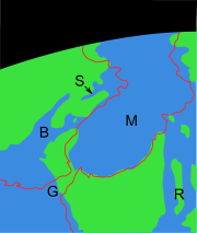
 Some major questions remain concerning the beginning of the crisis in the central Mediterranean Basin. The geometric physical link between the evaporitic series identified in marginal basins accessible for field studies, such as the Tabernas basin and Sorbas basin
, and the evaporitic series of the central basins has never been made.
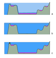
Using the concept of deposition in both shallow and deep basins during the Messinian (i.e. assuming that both Basin types existed during this period), two major groupings are evident: one that favours a synchronous deposition (image c) of the first evaporites in all the basins before the major phase of erosion (Krijgsman et al., 1999); and the other that favours a diachronous deposition (image a) of the evaporites through more than one phases of desiccation which would first have affected the marginal basins and later the central basins (Clauzon et al., 1996).
Another school suggests that desiccation was synchronous, but occurred mainly in shallower basins. This model would suggest that the sea level of the whole Mediterranean basin fell at once, but only shallower basins dried out enough to deposit salt beds. See image b.
As highlighted in the work of van Dijk (1992) and van Dijk et al. (1998) the history of desiccation and erosion was complexely interacting with tectonic uplift and subsidence events, and erosional episodes. They also questioned whether the basins now observed as "deep" were actually also deep during the Messinian Episode and gave different names to the end-member scenario's described above.
Distinguishing between these hypotheses requires the calibration of gypsum deposits. Gypsum is the first salt (calcium sulphate) to be deposited from a desiccating basin. Magnetostratigraphy
offers a broad constraint on timing, but no fine detail. Therefore, cyclostratigraphy
is relied upon to compare the dates of sediments.
The typical case study compares the gypsum evaporites in the main Mediterranean basin with those of the Sorbas basin
, a smaller basin on the flanks of the Mediterranean Sea that is now exposed in southern Spain. The relationship between these two basins is assumed to represent the relationships of the wider region.
Recent work has relied on cyclostratigraphy to correlate the underlying marl beds, which appear to be have given way to gypsum at exactly the same time in both basins. The proponents of this hypothesis claim that cyclic variations in bed compositions are astronomically tuned, and the beds' magnitude can be calibrated to show they were contemporaneous - a strong argument. In order to refute it, it is necessary to propose an alternative mechanism for generating these cyclic bands, or for erosion to have coincidentally removed just the right amount of sediment everywhere before the gypsum was deposited. The proponents claim that the gypsum was deposited directly above the correlated marl layers, and slumped into them, giving the appearance of an unconformable contact. However, their opponents seize upon this apparent inconformity, and claim that the Sorbas basin was exposed - therefore eroding - while the Mediterranean sea was depositing evaporites. This would result in the Sorbas basin being filled with evaporites at 5.5 million years ago (Ma), compared to the main basin at 5.96 Ma.
Recent works have highlighted a pre-evaporite phase corresponding to a prominent erosional crisis (also named "Messinian Erosional crisis
"; the termination of the "Mes-1" unconformity bound depositional sequence of van Dijk, 1992) responding to a major drawdown of the Mediterranean seawater. Assuming that this major drawdown corresponds to the major Messinian drawdown, they concluded that the Mediterranean bathymetry significantly decreased before the precipitation of central basins evaporites. Regarding these works, a deep water formation seems unlikely. The assumption that central basin evaporites partly deposited under a high bathymetry and before the major phase of erosion should imply the observation of a major detritic event above evaporites in the basin. Such a depositional geometry has not been observed on data. This theory corresponds to one of the end-member scenarios discussed by van Dijk et al. (1998).
In any case, the causes of the closing and isolation of the Mediterranean Sea from the Atlantic Ocean must be found in the area where nowadays the Strait of Gibraltar
is located. In that area, one of the tectonic boundaries between the African Plate
and the European Plate and its southern fragments such as the Iberian Plate
, is located. This boundary Zone is characterised by the presence of an Arc Shaped tectonic feature, the Alboran Arc
, which unites southern Spain with northern Africa. In the Present Day area of the Mediterranean Sea, three of these Arc shaped belts are present: the Alboran Arc, the Calabrian Arc, and the Aegean Arc
. The kinematics and dynamics of this Plate Boundary and of the Alboran Arc during the late Miocene are strictly related to the causes of the Messinian Salinity Crisis: Tectonic reconfiguration may have closed and re-opened passages; the region where the connection with the Atlantic Ocean was situated is permeated by strike-slip faults and rotating blocks of continental crust. As faulting accommodated the regional compression caused by Africa's convergence with Eurasia, the geography of the region may have altered enough to open and close seaways. However, the precise tectonic activity behind the motion can be interpreted in a number of ways. An extensive discussion can be found in Weijermars (1988).
Any model must explain a variety of features of the area:
There are three contending geodynamic models that may fit the data, models which have been discussed in an equal way for the other Arc shaped features in the Mediterranean (see for a systematic review van Dijk & Okkes, 1990):
Of these, only the first model, invoking rollback, can explain the rotations observed. However, it is difficult to fit it with the pressure and temperature histories of some metamorphic rocks.
This has led to some bizarre and interesting combinations of the models, in attempts to approach the true state of affairs.
Changes in climate must almost certainly be invoked to explain the periodic nature of the events. They occur during cool periods of Milankovic cycles, when less solar energy reached the Earth. This led to less evaporation of the North Atlantic, hence less rainfall over the Mediterranean. This would have starved the basin of water supply from rivers and allowed its desiccation.
Contrary to many people's instincts, there is now a scientific consensus that global sea level fluctuations cannot have been the major cause, although it may have played a role. The lack of ice caps at the time means there was no realistic mechanism to cause significant changes in sea level - there was nowhere for the water to go, and the morphology of ocean basins cannot change on such a short timescale.
was ultimately breached, the Atlantic Ocean
would have poured a vast volume of water through what would have presumably been a relatively narrow channel. This refill has been envisaged as resulting in a large waterfall
higher than today's Angel Falls (979 m), and far more powerful than either the Iguazu Falls
or the Niagara Falls
, but recent studies of the underground structures at the Gibraltar Strait show that the flooding channel descended in a rather gradual way to the dry Mediterranean.
 There had been speculations about a possible dehydration of the Mediterranean Sea in the distant past, even before geology developed.
Mediterranean Sea
The Mediterranean Sea is a sea connected to the Atlantic Ocean surrounded by the Mediterranean region and almost completely enclosed by land: on the north by Anatolia and Europe, on the south by North Africa, and on the east by the Levant...
went into a cycle of partly or nearly complete desiccation throughout the latter part of the Messinian
Messinian
The Messinian is in the geologic timescale the last age or uppermost stage of the Miocene. It spans the time between 7.246 ± 0.005 Ma and 5.332 ± 0.005 Ma...
age of the Miocene
Miocene
The Miocene is a geological epoch of the Neogene Period and extends from about . The Miocene was named by Sir Charles Lyell. Its name comes from the Greek words and and means "less recent" because it has 18% fewer modern sea invertebrates than the Pliocene. The Miocene follows the Oligocene...
epoch, from 5.96 to 5.33 Ma (million years ago). It ended with the so-called Zanclean flood
Zanclean flood
The Zanclean flood is a flood theorized to have refilled the Mediterranean Sea 5.33 million years ago, at the beginning of the Zanclean age, between the Miocene and Pliocene, which ended the Messinian salinity crisis...
, when the Atlantic reclaimed the basin.
Sediment samples from below the deep seafloor of the Mediterranean Sea, which include evaporite
Evaporite
Evaporite is a name for a water-soluble mineral sediment that result from concentration and crystallization by evaporation from an aqueous solution. There are two types of evaporate deposits, marine which can also be described as ocean deposits, and non-marine which are found in standing bodies of...
minerals, soils, and fossil
Fossil
Fossils are the preserved remains or traces of animals , plants, and other organisms from the remote past...
plants, show that about 5.96 million years ago in the late Miocene
Miocene
The Miocene is a geological epoch of the Neogene Period and extends from about . The Miocene was named by Sir Charles Lyell. Its name comes from the Greek words and and means "less recent" because it has 18% fewer modern sea invertebrates than the Pliocene. The Miocene follows the Oligocene...
period the precursor of the Strait of Gibraltar
Strait of Gibraltar
The Strait of Gibraltar is a narrow strait that connects the Atlantic Ocean to the Mediterranean Sea and separates Spain in Europe from Morocco in Africa. The name comes from Gibraltar, which in turn originates from the Arabic Jebel Tariq , albeit the Arab name for the Strait is Bab el-Zakat or...
closed tight, and the Mediterranean Sea, for the first time and then repeatedly, partially desiccated. 5.6 Ma ago the strait closed one last, final time, and because of the generally dry climate conditions, within a millennium the Mediterranean basin nearly completely desiccated, evaporating into a deep dry basin bottoming at some places 3 to 5 km below the world ocean level, with a few hypersaline Dead-Sea
Dead Sea
The Dead Sea , also called the Salt Sea, is a salt lake bordering Jordan to the east and Israel and the West Bank to the west. Its surface and shores are below sea level, the lowest elevation on the Earth's surface. The Dead Sea is deep, the deepest hypersaline lake in the world...
-like pockets. Around 5.5 Ma less dry climatic conditions allowed the basin to resume receiving more fresh water from rivers, with pockets of Caspian
Caspian Sea
The Caspian Sea is the largest enclosed body of water on Earth by area, variously classed as the world's largest lake or a full-fledged sea. The sea has a surface area of and a volume of...
-like brackish waters getting progressively less hyper-saline, until the final reopening of the Strait of Gibraltar 5.33 Ma with the Zanclean flooding.
Even now the Mediterranean is saltier than the North Atlantic because of its near isolation by the Strait of Gibraltar
Strait of Gibraltar
The Strait of Gibraltar is a narrow strait that connects the Atlantic Ocean to the Mediterranean Sea and separates Spain in Europe from Morocco in Africa. The name comes from Gibraltar, which in turn originates from the Arabic Jebel Tariq , albeit the Arab name for the Strait is Bab el-Zakat or...
and its high rate of evaporation
Evaporation
Evaporation is a type of vaporization of a liquid that occurs only on the surface of a liquid. The other type of vaporization is boiling, which, instead, occurs on the entire mass of the liquid....
. If the Strait of Gibraltar closes again, which is likely to happen in the near geological future (though extremely distantly on a human time scale), the Mediterranean would mostly evaporate in about a thousand years. After that, continued northward movement of Africa may obliterate the Mediterranean: see Mediterranean Ridge
Mediterranean Ridge
The Mediterranean Ridge is a wide ridge in the bed of the Mediterranean Sea, running along a rough quarter circle from Calabria, south of Crete, to the southwest corner of Turkey, and from there eastwards south of Turkey, including Cyprus....
.
Naming and discovery
The Messinian salt deposits that are outcropping (because they were uplifted by tectonic activity during later episodes) in places like Messina in SicilySicily
Sicily is a region of Italy, and is the largest island in the Mediterranean Sea. Along with the surrounding minor islands, it constitutes an autonomous region of Italy, the Regione Autonoma Siciliana Sicily has a rich and unique culture, especially with regard to the arts, music, literature,...
, northeast Libya, Italy, and southern Spain have been described since the 19th century and it is then that the salinity crisis theory started to be developed.
Karl Mayer-Eymar (1826–1907) a Swiss geologist and palaeontologist, studied fossils between gypsum
Gypsum
Gypsum is a very soft sulfate mineral composed of calcium sulfate dihydrate, with the chemical formula CaSO4·2H2O. It is found in alabaster, a decorative stone used in Ancient Egypt. It is the second softest mineral on the Mohs Hardness Scale...
-bearing, brackish
Brackish water
Brackish water is water that has more salinity than fresh water, but not as much as seawater. It may result from mixing of seawater with fresh water, as in estuaries, or it may occur in brackish fossil aquifers. The word comes from the Middle Dutch root "brak," meaning "salty"...
and freshwater sediment layers and identified them as having been deposited just before the end of the Miocene
Miocene
The Miocene is a geological epoch of the Neogene Period and extends from about . The Miocene was named by Sir Charles Lyell. Its name comes from the Greek words and and means "less recent" because it has 18% fewer modern sea invertebrates than the Pliocene. The Miocene follows the Oligocene...
Epoch. In 1867 he named the period the Messinian, for the region of Messina. Since then salt-bearing and gypsum-bearing evaporite
Evaporite
Evaporite is a name for a water-soluble mineral sediment that result from concentration and crystallization by evaporation from an aqueous solution. There are two types of evaporate deposits, marine which can also be described as ocean deposits, and non-marine which are found in standing bodies of...
layers in many Mediterranean countries have been dated to that period.
In 1961, seismic surveying of the Mediterranean basin revealed a geological feature some 100–200 metres below the seafloor. This feature, dubbed the M reflector, closely followed the contours of the present seafloor, suggesting that it was laid down evenly and consistently at some point in the past. The origin of this layer was largely interpreted as related to salt deposition. However, different interpretations were proposed for the age of salt and its deposition.
Earlier suggestions from Denizot in 1957 and Ruggieri in 1967 proposed that this layer was Late Miocene in Age, and the same Ruggeri coined the term Messinian Salinity Crisis.
New and high quality seismic data on the M-reflector were acquired in the Mediterranean Basin in 1970, published by e.g. Auzende et al. (1971) At the same time, the salt was cored during Leg 13 of the Deep Sea Drilling Program
Deep Sea Drilling Program
The Deep Sea Drilling Project was an ocean drilling project operated from 1968 to 1983. The program was considered to be successful as evidenced by the data and publications that have resulted from it and is now supported by Texas A&M University, although for the years of its operations these were...
conducted from the Glomar Challenger
Glomar Challenger
The 120m long Glomar Challenger was a deep sea research and scientific drilling vessel for oceanography and marine geology studies. It was designed by Global Marine Inc...
under the supervision of co-chief scientists William B.F. Ryan and Kenneth J. Hsu
Kenneth J. Hsu
Kenneth J. Hsu Ph.D, M.A., born 28 June 1929, is a Swiss scientist, geologist, paleoclimatologist, oceanographer, government advisor, author, inventor and entrepreneur who was born in Nanjing, China.-Biography:EducationHsu Kenneth J. Hsu Ph.D, M.A., born 28 June 1929, is a Swiss scientist,...
. All these deposits were indisputably dated and interpreted for the first time as deep-basin products of the Messinian Salinity Crisis.
Evidence
Desiccation
Desiccation is the state of extreme dryness, or the process of extreme drying. A desiccant is a hygroscopic substance that induces or sustains such a state in its local vicinity in a moderately sealed container.-Science:...
of the Mediterranean Sea came in the summer of 1970, when geologists aboard the Deep Sea Drilling Program
Deep Sea Drilling Program
The Deep Sea Drilling Project was an ocean drilling project operated from 1968 to 1983. The program was considered to be successful as evidenced by the data and publications that have resulted from it and is now supported by Texas A&M University, although for the years of its operations these were...
drillship Glomar Challenger
Glomar Challenger
The 120m long Glomar Challenger was a deep sea research and scientific drilling vessel for oceanography and marine geology studies. It was designed by Global Marine Inc...
brought up drill cores containing arroyo
Arroyo (creek)
An arroyo , a Spanish word translated as brook, and also called a wash is usually a dry creek or stream bed—gulch that temporarily or seasonally fills and flows after sufficient rain. Wadi is a similar term in Africa. In Spain, a rambla has a similar meaning to arroyo.-Types and processes:Arroyos...
gravels and red and green floodplain
Floodplain
A floodplain, or flood plain, is a flat or nearly flat land adjacent a stream or river that stretches from the banks of its channel to the base of the enclosing valley walls and experiences flooding during periods of high discharge...
silts; and gypsum
Gypsum
Gypsum is a very soft sulfate mineral composed of calcium sulfate dihydrate, with the chemical formula CaSO4·2H2O. It is found in alabaster, a decorative stone used in Ancient Egypt. It is the second softest mineral on the Mohs Hardness Scale...
, anhydrite
Anhydrite
Anhydrite is a mineral – anhydrous calcium sulfate, CaSO4. It is in the orthorhombic crystal system, with three directions of perfect cleavage parallel to the three planes of symmetry. It is not isomorphous with the orthorhombic barium and strontium sulfates, as might be expected from the...
, rock salt
Halite
Halite , commonly known as rock salt, is the mineral form of sodium chloride . Halite forms isometric crystals. The mineral is typically colorless or white, but may also be light blue, dark blue, purple, pink, red, orange, yellow or gray depending on the amount and type of impurities...
, and various other evaporite
Evaporite
Evaporite is a name for a water-soluble mineral sediment that result from concentration and crystallization by evaporation from an aqueous solution. There are two types of evaporate deposits, marine which can also be described as ocean deposits, and non-marine which are found in standing bodies of...
minerals that often form from drying of brine
Brine
Brine is water, saturated or nearly saturated with salt .Brine is used to preserve vegetables, fruit, fish, and meat, in a process known as brining . Brine is also commonly used to age Halloumi and Feta cheeses, or for pickling foodstuffs, as a means of preserving them...
or seawater, including in a few places potash
Potash
Potash is the common name for various mined and manufactured salts that contain potassium in water-soluble form. In some rare cases, potash can be formed with traces of organic materials such as plant remains, and this was the major historical source for it before the industrial era...
, left where the last bitter, mineral-rich waters dried up. One drill core contained a wind-blown cross-bedded
Cross-bedding
In geology, the sedimentary structures known as cross-bedding refer to horizontal units that are internally composed of inclined layers. This is a case in geology in which the original depositional layering is tilted, and the tilting is not a result of post-depositional deformation...
deposit of deep-sea foraminifera
Foraminifera
The Foraminifera , or forams for short, are a large group of amoeboid protists which are among the commonest plankton species. They have reticulating pseudopods, fine strands of cytoplasm that branch and merge to form a dynamic net...
l ooze that had dried into dust and been blown about on the hot dry abyssal plain
Abyssal plain
An abyssal plain is an underwater plain on the deep ocean floor, usually found at depths between 3000 and 6000 metres. Lying generally between the foot of a continental rise and a mid-ocean ridge, abyssal plains cover more than 50% of the Earth’s surface. They are among the flattest, smoothest...
by sandstorm
Dust storm
A dust / sand storm is a meteorological phenomenon common in arid and semi-arid regions. Dust storms arise when a gust front or other strong wind blows loose sand and dirt from a dry surface. Particles are transported by saltation and suspension, causing soil to move from one place and deposition...
s and ended up in a brine
Brine
Brine is water, saturated or nearly saturated with salt .Brine is used to preserve vegetables, fruit, fish, and meat, in a process known as brining . Brine is also commonly used to age Halloumi and Feta cheeses, or for pickling foodstuffs, as a means of preserving them...
lake interbedded between two layers of halite
Halite
Halite , commonly known as rock salt, is the mineral form of sodium chloride . Halite forms isometric crystals. The mineral is typically colorless or white, but may also be light blue, dark blue, purple, pink, red, orange, yellow or gray depending on the amount and type of impurities...
. These layers alternated with layers containing marine fossils, indicating a succession of drying and flooding periods.
Other evidence of drying comes from the remains of many (now submerged) canyons that were cut into the sides of the dry Mediterranean basin by rivers flowing down to the abyssal plain
Abyssal plain
An abyssal plain is an underwater plain on the deep ocean floor, usually found at depths between 3000 and 6000 metres. Lying generally between the foot of a continental rise and a mid-ocean ridge, abyssal plains cover more than 50% of the Earth’s surface. They are among the flattest, smoothest...
. For example, the Nile
Nile
The Nile is a major north-flowing river in North Africa, generally regarded as the longest river in the world. It is long. It runs through the ten countries of Sudan, South Sudan, Burundi, Rwanda, Democratic Republic of the Congo, Tanzania, Kenya, Ethiopia, Uganda and Egypt.The Nile has two major...
cut its bed down to several hundred feet below sea level at Aswan
Aswan
Aswan , formerly spelled Assuan, is a city in the south of Egypt, the capital of the Aswan Governorate.It stands on the east bank of the Nile at the first cataract and is a busy market and tourist centre...
(where Ivan S. Chumakov found marine Pliocene foraminifers in 1967), and 2,500 m
Metre
The metre , symbol m, is the base unit of length in the International System of Units . Originally intended to be one ten-millionth of the distance from the Earth's equator to the North Pole , its definition has been periodically refined to reflect growing knowledge of metrology...
(8,000 ft) below sea level just north of Cairo
Cairo
Cairo , is the capital of Egypt and the largest city in the Arab world and Africa, and the 16th largest metropolitan area in the world. Nicknamed "The City of a Thousand Minarets" for its preponderance of Islamic architecture, Cairo has long been a centre of the region's political and cultural life...
.
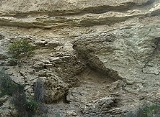
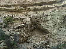
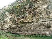
In many places in the Mediterranean, fossilized cracks have been found where muddy sediment had dried and cracked in the sunlight and drought. In the Western Mediterranean series, the presence of pelagic oozes
Pelagic sediments
Pelagic sediment or pelagite is a fine-grained sediment that has accumulated by the settling of particles through the water column to the ocean floor beneath the open ocean far from land. These particles consist primarily of either the microscopic, calcareous or siliceous shells of phytoplankton or...
interbedded within the evaporites suggests that the area was repeatedly flooded and desiccated over the course of 700,000 years.
Scholarship
After the discovery, the definition, and the scientific acceptance of this particular event in Geological History, since the early seventies of the 20th century, numerous conferences, workshops, M.Sc and Ph.D. researches, reviews and special volumes have been dedicated to this argument.Chronology
Based on palaeomagnetic datings of MessinianMessinian
The Messinian is in the geologic timescale the last age or uppermost stage of the Miocene. It spans the time between 7.246 ± 0.005 Ma and 5.332 ± 0.005 Ma...
deposits that have since been brought above sea level by tectonic activity, the salinity crisis started at the same time over all the Mediterranean basin, at 5.96 ± 0.02 million years ago. It must be underlined that this episode comprises the second part of what is called the "Messinian
Messinian
The Messinian is in the geologic timescale the last age or uppermost stage of the Miocene. It spans the time between 7.246 ± 0.005 Ma and 5.332 ± 0.005 Ma...
" Epoch. The Epoch was characterised by several stages of tectonic activity and sea level fluctuations, and erosional and depositional events, all more or less interrelated (van Dijk et al., 1998).
The Mediterranean-Atlantic strait closed tight time and again, and the Mediterranean Sea, for the first time and then repeatedly, partially desiccated. The basin was finally isolated from the Atlantic Ocean
Atlantic Ocean
The Atlantic Ocean is the second-largest of the world's oceanic divisions. With a total area of about , it covers approximately 20% of the Earth's surface and about 26% of its water surface area...
for a longer period, between 5.59 and 5.33 million years ago, resulting in a large or smaller (depending on the scientific model applied) lowering of the Mediterranean sea level. During the initial, very dry stages (5.6–5.5 Ma), there was extensive erosion, creating several huge canyon systems (some similar in scale to the Grand Canyon
Grand Canyon
The Grand Canyon is a steep-sided canyon carved by the Colorado River in the United States in the state of Arizona. It is largely contained within the Grand Canyon National Park, the 15th national park in the United States...
) around the Mediterranean. Later stages (5.50–5.33 Ma) are marked by cyclic evaporite
Evaporite
Evaporite is a name for a water-soluble mineral sediment that result from concentration and crystallization by evaporation from an aqueous solution. There are two types of evaporate deposits, marine which can also be described as ocean deposits, and non-marine which are found in standing bodies of...
deposition into a large "lake-sea" basin ("Lago Mare" event).
About 5.33 million years ago, at the start of the Zanclean
Zanclean
The Zanclean is the lowest stage or earliest age on the geologic time scale of the Pliocene. It spans the time between 5.332 and 3.6 Ma ± 0.005 Ma . It is preceded by the Messinian age of the Miocene epoch, and followed by the Piacenzian age....
age (at the start of the Pliocene
Pliocene
The Pliocene Epoch is the period in the geologic timescale that extends from 5.332 million to 2.588 million years before present. It is the second and youngest epoch of the Neogene Period in the Cenozoic Era. The Pliocene follows the Miocene Epoch and is followed by the Pleistocene Epoch...
epoch), the barrier at the Strait of Gibraltar broke one last time, re-flooding the Mediterranean basin in the Zanclean flood
Zanclean flood
The Zanclean flood is a flood theorized to have refilled the Mediterranean Sea 5.33 million years ago, at the beginning of the Zanclean age, between the Miocene and Pliocene, which ended the Messinian salinity crisis...
; the basin has not desiccated since.
Several cycles
The amount of Messinian salts is larger than 4·1018 kg (Ryan, 2008, Sedimentology), exceeding by a factor of 50 the amount of salt normally contained in the Mediterranean waters. This suggests either a succession of desiccations or a long period of hypersalinity during which incoming water from the Atlantic Ocean was evaporated with the level of the Mediterranean brine being similar to that of the Atlantic The nature of the strataStratum
In geology and related fields, a stratum is a layer of sedimentary rock or soil with internally consistent characteristics that distinguish it from other layers...
points strongly to several cycles of the Mediterranean Sea completely drying and being refilled, with drying periods correlating to periods of cooler global temperature; which were therefore drier in the Mediterranean region. Each refilling was presumably caused by a seawater inlet opening, either tectonically, or by a river flowing eastwards below sea level into the "Mediterranean Sink" cutting its valley head back west until it let the sea in, similarly to a river capture
River capture
Stream capture, river capture, or stream piracy is a geomorphological phenomenon occurring when a stream or river drainage system or watershed is diverted from its own bed, and flows instead down the bed of a neighbouring stream...
. The last refilling was at the Miocene
Miocene
The Miocene is a geological epoch of the Neogene Period and extends from about . The Miocene was named by Sir Charles Lyell. Its name comes from the Greek words and and means "less recent" because it has 18% fewer modern sea invertebrates than the Pliocene. The Miocene follows the Oligocene...
/Pliocene
Pliocene
The Pliocene Epoch is the period in the geologic timescale that extends from 5.332 million to 2.588 million years before present. It is the second and youngest epoch of the Neogene Period in the Cenozoic Era. The Pliocene follows the Miocene Epoch and is followed by the Pleistocene Epoch...
boundary, when the Strait of Gibraltar
Strait of Gibraltar
The Strait of Gibraltar is a narrow strait that connects the Atlantic Ocean to the Mediterranean Sea and separates Spain in Europe from Morocco in Africa. The name comes from Gibraltar, which in turn originates from the Arabic Jebel Tariq , albeit the Arab name for the Strait is Bab el-Zakat or...
broke wide open permanently. Upon closely examining the Hole 124 core, Kenneth J. Hsu
Kenneth J. Hsu
Kenneth J. Hsu Ph.D, M.A., born 28 June 1929, is a Swiss scientist, geologist, paleoclimatologist, oceanographer, government advisor, author, inventor and entrepreneur who was born in Nanjing, China.-Biography:EducationHsu Kenneth J. Hsu Ph.D, M.A., born 28 June 1929, is a Swiss scientist,...
found that:
Research since then has confirmed that the desiccation-flooding cycle repeated itself at least eight times during the last 630,000 years of the Miocene epoch.
Dehydrated geography
- At the time, the Strait of GibraltarStrait of GibraltarThe Strait of Gibraltar is a narrow strait that connects the Atlantic Ocean to the Mediterranean Sea and separates Spain in Europe from Morocco in Africa. The name comes from Gibraltar, which in turn originates from the Arabic Jebel Tariq , albeit the Arab name for the Strait is Bab el-Zakat or...
was not open, but other seaways (the Betic corridorBetic corridorThe Betic Corridor, or North-Betic Strait, was a strait of water connecting the Mediterranean Sea with the Atlantic Ocean that once separated the Iberian plate from the Eurasian plate through the Betic Cordillera...
to the north where the Sierra NevadaSierra Nevada (Spain)The Sierra Nevada is a mountain range in the region of provinces of Granada and Almería in Spain. It contains the highest point of continental Spain, Mulhacén at 3478 m above sea level....
or Baetic CordilleraBaetic CordilleraThe Baetic System is the main system of mountain ranges in Spain. Located in southern and eastern Spain, it is also known as the Baetic Cordillera, Baetic Ranges or Baetic Mountains...
is now, or to the south where the Rifean corridor or corridors where the Rif Mountains are now) linked the Mediterranean to the Atlantic. These must have closed, isolating the basin from the open ocean. - The high level of salinity cannot be tolerated by many known organisms, most likely reducing the biodiversity of much of the basin.
- The basin's low altitude would have made it extremely hot during the summer through adiabatic heatingAdiabatic processIn thermodynamics, an adiabatic process or an isocaloric process is a thermodynamic process in which the net heat transfer to or from the working fluid is zero. Such a process can occur if the container of the system has thermally-insulated walls or the process happens in an extremely short time,...
, a conclusion supported by the presence of anhydriteAnhydriteAnhydrite is a mineral – anhydrous calcium sulfate, CaSO4. It is in the orthorhombic crystal system, with three directions of perfect cleavage parallel to the three planes of symmetry. It is not isomorphous with the orthorhombic barium and strontium sulfates, as might be expected from the...
, which is only deposited in water warmer than 35°C (95°F). - Rivers emptying into the basin would have cut their beds much deeper (at least a further 2,400 m or 8,000 feet in the case of the NileNileThe Nile is a major north-flowing river in North Africa, generally regarded as the longest river in the world. It is long. It runs through the ten countries of Sudan, South Sudan, Burundi, Rwanda, Democratic Republic of the Congo, Tanzania, Kenya, Ethiopia, Uganda and Egypt.The Nile has two major...
, as the buried canyon under CairoCairoCairo , is the capital of Egypt and the largest city in the Arab world and Africa, and the 16th largest metropolitan area in the world. Nicknamed "The City of a Thousand Minarets" for its preponderance of Islamic architecture, Cairo has long been a centre of the region's political and cultural life...
shows).
Climate
The climate of the abyssal plain during the drought is unknown. There is no situation on Earth directly comparable to the dry Mediterranean, and thus it is not possible to know its climate. There is not even a consensus as to whether the Mediterranean Sea even dried out completely; it seems likeliest that at least three or four large brine lakeBrine lake
Brine lakes consist of water that has reached salt saturation or near saturation , and may also be heavily saturated with other materials....
s on the abyssal plain
Abyssal plain
An abyssal plain is an underwater plain on the deep ocean floor, usually found at depths between 3000 and 6000 metres. Lying generally between the foot of a continental rise and a mid-ocean ridge, abyssal plains cover more than 50% of the Earth’s surface. They are among the flattest, smoothest...
s remained at all times. The extent of desiccation is very hard to judge due to the reflective seismic nature of the salt beds, and the difficulty in drilling cores, making it difficult to map their thickness.
Nonetheless, one can study the forces at play in the atmosphere to arrive at a good speculation of the climate. As winds blew across the "Mediterranean Sink
Sink (geography)
A geographic sink is a depression within an endorheic basin where water collects with no visible outlet. Instead of discharging, the collected water is lost due to evaporation and/or penetration...
", they would heat or cool adiabatically with altitude. As a result, the rule that "cold air falls and hot air rises" has to be adjusted by considering how hot each bit of air would be if brought adiabatically to sea-level pressure.
In the empty Mediterranean Basin the summertime temperatures would likely have been extremely high. Using the Clausius-Clapeyron relation
Clausius-Clapeyron relation
The Clausius–Clapeyron relation, named after Rudolf Clausius and Benoît Paul Émile Clapeyron, who defined it sometime after 1834, is a way of characterizing a discontinuous phase transition between two phases of matter. On a pressure–temperature diagram, the line separating the two phases is known...
, one can derive an equation giving the dry adiabatic lapse rate
Lapse rate
The lapse rate is defined as the rate of decrease with height for an atmospheric variable. The variable involved is temperature unless specified otherwise. The terminology arises from the word lapse in the sense of a decrease or decline; thus, the lapse rate is the rate of decrease with height and...
of around 10°C (18°F) per kilometer, showing that a theoretical temperature of an area 4 kilometres (2.5 mi) below sea level would be about 40°C (72°F) warmer than the temperature at sea level. Thus one could predict theoretical temperature maximums of around 80°C (176 °F) at the lowest depths of the dry abyssal plain permitting little known life to survive there. One can also calculate that 2 to 3 miles (3.2 - 4.8 km) below sea level would have resulted in 1.45 to 1.71 atm (1,102 to 1,300 mmHg) of air pressure at the bottom. Although it was likely quite dry in the Basin, there is no direct way to measure how much drier it would have been compared to its surroundings. Areas with less severe depths would likely have been very dry.
Today the evaporation from the Mediterranean Sea supplies moisture that falls in frontal storms, but without such moisture, the Mediterranean climate
Mediterranean climate
A Mediterranean climate is the climate typical of most of the lands in the Mediterranean Basin, and is a particular variety of subtropical climate...
that we associate with Italy, Greece, and the Levant would be limited to the Iberian Peninsula
Iberian Peninsula
The Iberian Peninsula , sometimes called Iberia, is located in the extreme southwest of Europe and includes the modern-day sovereign states of Spain, Portugal and Andorra, as well as the British Overseas Territory of Gibraltar...
and the western Maghreb
Maghreb
The Maghreb is the region of Northwest Africa, west of Egypt. It includes five countries: Morocco, Algeria, Tunisia, Libya, and Mauritania and the disputed territory of Western Sahara...
. Climates throughout the central and eastern basin of the Mediterranean and surrounding regions to the north and east would have been drier even above modern sea level. The eastern Alps, the Balkans, and the Hungarian plain would also be much drier than they are today, even if the westerlies prevailed as they do now. However, the Paratethys
Paratethys
The Paratethys ocean, Paratethys sea or just Paratethys was a large shallow sea that stretched from the region north of the Alps over Central Europe to the Aral Sea in western Asia. The sea was formed during the Oxfordian epoch as an extension of the rift that formed the Central Atlantic Ocean and...
ocean provided water to the area north of the Mediterranean basin. The Wallachian-Pontic and Hungarian basins were underwater during the Miocene, modifying the climate of what is now the Balkans and other areas north of the Mediterranean basin. The Pannonian Sea
Pannonian Sea
The Pannonian Sea was a shallow ancient sea located in the area today known as the Pannonian Plain in Central Europe. The Pannonian Sea existed during the Miocene and Pliocene epochs, when three to four kilometres of marine sediments were deposited in the Pannonian Basin.-History:The Pannonian Sea...
was a source of water north of the Mediterranean basin until the middle Pleistocene before becoming the Hungarian plain. Debate exists whether the waters of the Wallachian-Pontic basin (and the possibly connected Pannonian Sea
Pannonian Sea
The Pannonian Sea was a shallow ancient sea located in the area today known as the Pannonian Plain in Central Europe. The Pannonian Sea existed during the Miocene and Pliocene epochs, when three to four kilometres of marine sediments were deposited in the Pannonian Basin.-History:The Pannonian Sea...
) would have had access (thus bringing water) to at least the eastern Mediterranean basin at times during the Miocene.
The Messinian event provided also an opportunity to many African species, including antelope
Antelope
Antelope is a term referring to many even-toed ungulate species indigenous to various regions in Africa and Eurasia. Antelopes comprise a miscellaneous group within the family Bovidae, encompassing those old-world species that are neither cattle, sheep, buffalo, bison, nor goats...
s, elephant
Elephant
Elephants are large land mammals in two extant genera of the family Elephantidae: Elephas and Loxodonta, with the third genus Mammuthus extinct...
and hippopotamus
Hippopotamus
The hippopotamus , or hippo, from the ancient Greek for "river horse" , is a large, mostly herbivorous mammal in sub-Saharan Africa, and one of only two extant species in the family Hippopotamidae After the elephant and rhinoceros, the hippopotamus is the third largest land mammal and the heaviest...
to migrate into the empty basin, obviously close to the descending great rivers, to reach interior wetter cooler highlands such as Malta
Malta
Malta , officially known as the Republic of Malta , is a Southern European country consisting of an archipelago situated in the centre of the Mediterranean, south of Sicily, east of Tunisia and north of Libya, with Gibraltar to the west and Alexandria to the east.Malta covers just over in...
: as the sea level was dropping, as such species would not have been able to cross the wide hot empty sink at maximum dryness. After the return of the sea water, they remained on the islands, where they underwent insular dwarfism
Insular dwarfism
Insular dwarfism, a form of phyletic dwarfism, is the process and condition of the reduction in size of large animals – typically mammals – when their population's range is limited to a small environment, primarily islands. This natural process is distinct from the intentional creation of dwarf...
during the Pleistocene as on Crete
Crete
Crete is the largest and most populous of the Greek islands, the fifth largest island in the Mediterranean Sea, and one of the thirteen administrative regions of Greece. It forms a significant part of the economy and cultural heritage of Greece while retaining its own local cultural traits...
(Hippopotamus creutzburgi), on Cyprus
Cyprus
Cyprus , officially the Republic of Cyprus , is a Eurasian island country, member of the European Union, in the Eastern Mediterranean, east of Greece, south of Turkey, west of Syria and north of Egypt. It is the third largest island in the Mediterranean Sea.The earliest known human activity on the...
(H. minor
Cyprus Dwarf Hippopotamus
The Cyprus Dwarf Hippopotamus or Cypriot Pygmy Hippopotamus is an extinct species of hippopotamus that inhabited the island of Cyprus until the early Holocene....
), on Malta
Malta
Malta , officially known as the Republic of Malta , is a Southern European country consisting of an archipelago situated in the centre of the Mediterranean, south of Sicily, east of Tunisia and north of Libya, with Gibraltar to the west and Alexandria to the east.Malta covers just over in...
(H. melitensis
Maltese Hippopotamus
Hippopotamus melitensis is an extinct hippopotamus. It arrived after the Messinian salinity crisis and lived during the Pleistocene on Malta. The absence of predators led to the dwarfing of the hippos...
) and Sicily
Sicily
Sicily is a region of Italy, and is the largest island in the Mediterranean Sea. Along with the surrounding minor islands, it constitutes an autonomous region of Italy, the Regione Autonoma Siciliana Sicily has a rich and unique culture, especially with regard to the arts, music, literature,...
(H. pentlandi
Sicilian Hippopotamus
Hippopotamus pentlandi is an extinct hippopotamus. It arrived after the Messinian salinity crisis and lived during the Pleistocene on Sicily...
). Of these, the Cyprus Dwarf Hippopotamus
Cyprus Dwarf Hippopotamus
The Cyprus Dwarf Hippopotamus or Cypriot Pygmy Hippopotamus is an extinct species of hippopotamus that inhabited the island of Cyprus until the early Holocene....
, survived until the end of the Pleistocene
Pleistocene
The Pleistocene is the epoch from 2,588,000 to 11,700 years BP that spans the world's recent period of repeated glaciations. The name pleistocene is derived from the Greek and ....
or early Holocene. But some of these species may have crossed the sea when it was flooded, washed out to sea on rafts of floating vegetation, or with some species (e.g. elephants) by swimming.
Synchronism vs Diachronism - Deep water vs shallow water evaporites
Sorbas basin
The Sorbas basin is a sedimentary basin around the town of Sorbas in south-east Spain. It is believed to have been formed by extension, between two fault-bounded blocks which rotated anti-clockwise to take up the compression resulting from Europe's collision with Africa...
, and the evaporitic series of the central basins has never been made.
Using the concept of deposition in both shallow and deep basins during the Messinian (i.e. assuming that both Basin types existed during this period), two major groupings are evident: one that favours a synchronous deposition (image c) of the first evaporites in all the basins before the major phase of erosion (Krijgsman et al., 1999); and the other that favours a diachronous deposition (image a) of the evaporites through more than one phases of desiccation which would first have affected the marginal basins and later the central basins (Clauzon et al., 1996).
Another school suggests that desiccation was synchronous, but occurred mainly in shallower basins. This model would suggest that the sea level of the whole Mediterranean basin fell at once, but only shallower basins dried out enough to deposit salt beds. See image b.
As highlighted in the work of van Dijk (1992) and van Dijk et al. (1998) the history of desiccation and erosion was complexely interacting with tectonic uplift and subsidence events, and erosional episodes. They also questioned whether the basins now observed as "deep" were actually also deep during the Messinian Episode and gave different names to the end-member scenario's described above.
Distinguishing between these hypotheses requires the calibration of gypsum deposits. Gypsum is the first salt (calcium sulphate) to be deposited from a desiccating basin. Magnetostratigraphy
Magnetostratigraphy
Magnetostratigraphy is a geophysical correlation technique used to date sedimentary and volcanic sequences. The method works by collecting oriented samples at measured intervals throughout the section. The samples are analyzed to determine their characteristic remanent magnetization , that is, the...
offers a broad constraint on timing, but no fine detail. Therefore, cyclostratigraphy
Cyclostratigraphy
Cyclostratigraphy is the study of astronomically forced climate cycles within sedimentary successions . Astronomical cycles are variations of the Earth's orbit around the sun due to the gravitational interaction with other masses within the solar system. Due to this cyclicity solar irradiation...
is relied upon to compare the dates of sediments.
The typical case study compares the gypsum evaporites in the main Mediterranean basin with those of the Sorbas basin
Sorbas basin
The Sorbas basin is a sedimentary basin around the town of Sorbas in south-east Spain. It is believed to have been formed by extension, between two fault-bounded blocks which rotated anti-clockwise to take up the compression resulting from Europe's collision with Africa...
, a smaller basin on the flanks of the Mediterranean Sea that is now exposed in southern Spain. The relationship between these two basins is assumed to represent the relationships of the wider region.
Recent work has relied on cyclostratigraphy to correlate the underlying marl beds, which appear to be have given way to gypsum at exactly the same time in both basins. The proponents of this hypothesis claim that cyclic variations in bed compositions are astronomically tuned, and the beds' magnitude can be calibrated to show they were contemporaneous - a strong argument. In order to refute it, it is necessary to propose an alternative mechanism for generating these cyclic bands, or for erosion to have coincidentally removed just the right amount of sediment everywhere before the gypsum was deposited. The proponents claim that the gypsum was deposited directly above the correlated marl layers, and slumped into them, giving the appearance of an unconformable contact. However, their opponents seize upon this apparent inconformity, and claim that the Sorbas basin was exposed - therefore eroding - while the Mediterranean sea was depositing evaporites. This would result in the Sorbas basin being filled with evaporites at 5.5 million years ago (Ma), compared to the main basin at 5.96 Ma.
Recent works have highlighted a pre-evaporite phase corresponding to a prominent erosional crisis (also named "Messinian Erosional crisis
Messinian Erosional crisis
The Messinian Erosional Crisis is a pre-evaporite phase of the central Mediterranean basin responding to a major drawdown of the Mediterranean seawater ....
"; the termination of the "Mes-1" unconformity bound depositional sequence of van Dijk, 1992) responding to a major drawdown of the Mediterranean seawater. Assuming that this major drawdown corresponds to the major Messinian drawdown, they concluded that the Mediterranean bathymetry significantly decreased before the precipitation of central basins evaporites. Regarding these works, a deep water formation seems unlikely. The assumption that central basin evaporites partly deposited under a high bathymetry and before the major phase of erosion should imply the observation of a major detritic event above evaporites in the basin. Such a depositional geometry has not been observed on data. This theory corresponds to one of the end-member scenarios discussed by van Dijk et al. (1998).
Global effects
The water from the Mediterranean would have been redistributed in the world ocean, raising global sea level by as much as 10 meters (~33 feet).http://www.geo.arizona.edu/geo2xx/geo212.034/Lect17.html The Mediterranean basin also sequestered below its seabed a significant percentage of the salt from Earth's oceans; this decreased the average salinity of the world ocean and raised its freezing point.Causes
Several possible causes of the series of Messinian crises have been considered. While there is disagreement on all fronts, the most general consensus seems to agree that climate had a role in forcing the periodic filling and emptying of the basins, and that tectonic factors must have played a part in controlling the height of the sills restricting flow between the Atlantic and Mediterranean. The magnitude and extent of these effects, however, is widely open to interpretation (see e.g. van Dijk et al. (1998)).In any case, the causes of the closing and isolation of the Mediterranean Sea from the Atlantic Ocean must be found in the area where nowadays the Strait of Gibraltar
Strait of Gibraltar
The Strait of Gibraltar is a narrow strait that connects the Atlantic Ocean to the Mediterranean Sea and separates Spain in Europe from Morocco in Africa. The name comes from Gibraltar, which in turn originates from the Arabic Jebel Tariq , albeit the Arab name for the Strait is Bab el-Zakat or...
is located. In that area, one of the tectonic boundaries between the African Plate
African Plate
The African Plate is a tectonic plate which includes the continent of Africa, as well as oceanic crust which lies between the continent and various surrounding ocean ridges.-Boundaries:...
and the European Plate and its southern fragments such as the Iberian Plate
Iberian plate
The microcontinent Iberia encompassed not only the Iberian Peninsula but also Corsica, Sardinia, the Balearic Islands, and the Briançonnais zone of the Penninic nappes of the Alps...
, is located. This boundary Zone is characterised by the presence of an Arc Shaped tectonic feature, the Alboran Arc
Gibraltar Arc
The Gibraltar Arc is a geological region corresponding to an arcuate orogen surrounding the Alboran Sea, between the Iberian Peninsula and Africa. It consists of the Betic Cordillera , and the Rif ....
, which unites southern Spain with northern Africa. In the Present Day area of the Mediterranean Sea, three of these Arc shaped belts are present: the Alboran Arc, the Calabrian Arc, and the Aegean Arc
Hellenic arc
The Hellenic arc or Aegean arc is an arcuate tectonic feature of the eastern Mediterranean Sea related to the subduction of the African Plate beneath the Aegean Sea Plate...
. The kinematics and dynamics of this Plate Boundary and of the Alboran Arc during the late Miocene are strictly related to the causes of the Messinian Salinity Crisis: Tectonic reconfiguration may have closed and re-opened passages; the region where the connection with the Atlantic Ocean was situated is permeated by strike-slip faults and rotating blocks of continental crust. As faulting accommodated the regional compression caused by Africa's convergence with Eurasia, the geography of the region may have altered enough to open and close seaways. However, the precise tectonic activity behind the motion can be interpreted in a number of ways. An extensive discussion can be found in Weijermars (1988).
Any model must explain a variety of features of the area:
- Shortening and extension occur at the same time in close proximity; sediments constrain the rates of uplift and subsidence quite precisely
- Fault-bounded continental blocks can often be observed to rotate
- The depth and structure of the lithosphereLithosphereThe lithosphere is the rigid outermost shell of a rocky planet. On Earth, it comprises the crust and the portion of the upper mantle that behaves elastically on time scales of thousands of years or greater.- Earth's lithosphere :...
is constrained by records of seismic activity, as well as tomographyTomographyTomography refers to imaging by sections or sectioning, through the use of any kind of penetrating wave. A device used in tomography is called a tomograph, while the image produced is a tomogram. The method is used in radiology, archaeology, biology, geophysics, oceanography, materials science,... - The composition of igneous rocks varies - this constrains the location and extent of any subductionSubductionIn geology, subduction is the process that takes place at convergent boundaries by which one tectonic plate moves under another tectonic plate, sinking into the Earth's mantle, as the plates converge. These 3D regions of mantle downwellings are known as "Subduction Zones"...
.
There are three contending geodynamic models that may fit the data, models which have been discussed in an equal way for the other Arc shaped features in the Mediterranean (see for a systematic review van Dijk & Okkes, 1990):
- A moving subduction zone may have caused periodic regional uplift. Changes in volcanic rocks suggest that subduction zones at the rim of the Tethys Sea may have rolled back westwards, changing the chemistry and density in magma underlying the western Mediterranean. However, this does not account for the periodic emptying and refilling of the basin.
- The same features can be explained by regional delaminationDelamination (geology)In geophysics, delamination refers to the loss and sinking of the portion of the lowermost lithosphere from the tectonic plate to which it was attached.This can occur when the lower portion of the lithosphere becomes more dense than the surrounding mantle...
, the loss of a layer of the entire lithosphere.
- Deblobbing, the loss of a "blob" of lithospheric mantle, and the subsequent upward motion of the overlying crust (which has lost its dense mantle "anchor") may also have caused the observed phenomena, although the validity of the "deblobbing" hypothesis has been called into question.
Of these, only the first model, invoking rollback, can explain the rotations observed. However, it is difficult to fit it with the pressure and temperature histories of some metamorphic rocks.
This has led to some bizarre and interesting combinations of the models, in attempts to approach the true state of affairs.
Changes in climate must almost certainly be invoked to explain the periodic nature of the events. They occur during cool periods of Milankovic cycles, when less solar energy reached the Earth. This led to less evaporation of the North Atlantic, hence less rainfall over the Mediterranean. This would have starved the basin of water supply from rivers and allowed its desiccation.
Contrary to many people's instincts, there is now a scientific consensus that global sea level fluctuations cannot have been the major cause, although it may have played a role. The lack of ice caps at the time means there was no realistic mechanism to cause significant changes in sea level - there was nowhere for the water to go, and the morphology of ocean basins cannot change on such a short timescale.
Replenishment
When the Strait of GibraltarStrait of Gibraltar
The Strait of Gibraltar is a narrow strait that connects the Atlantic Ocean to the Mediterranean Sea and separates Spain in Europe from Morocco in Africa. The name comes from Gibraltar, which in turn originates from the Arabic Jebel Tariq , albeit the Arab name for the Strait is Bab el-Zakat or...
was ultimately breached, the Atlantic Ocean
Atlantic Ocean
The Atlantic Ocean is the second-largest of the world's oceanic divisions. With a total area of about , it covers approximately 20% of the Earth's surface and about 26% of its water surface area...
would have poured a vast volume of water through what would have presumably been a relatively narrow channel. This refill has been envisaged as resulting in a large waterfall
Waterfall
A waterfall is a place where flowing water rapidly drops in elevation as it flows over a steep region or a cliff.-Formation:Waterfalls are commonly formed when a river is young. At these times the channel is often narrow and deep. When the river courses over resistant bedrock, erosion happens...
higher than today's Angel Falls (979 m), and far more powerful than either the Iguazu Falls
Iguazu Falls
Iguazu Falls, Iguassu Falls, or Iguaçu Falls are waterfalls of the Iguazu River located on the border of the Brazilian State of Paraná and the Argentine Province of Misiones. The falls divide the river into the upper and lower Iguazu. The Iguazu River originates near the city of Curitiba. It flows...
or the Niagara Falls
Niagara Falls
The Niagara Falls, located on the Niagara River draining Lake Erie into Lake Ontario, is the collective name for the Horseshoe Falls and the adjacent American Falls along with the comparatively small Bridal Veil Falls, which combined form the highest flow rate of any waterfalls in the world and has...
, but recent studies of the underground structures at the Gibraltar Strait show that the flooding channel descended in a rather gradual way to the dry Mediterranean.
In popular culture
- In the first century, Pliny the ElderPliny the ElderGaius Plinius Secundus , better known as Pliny the Elder, was a Roman author, naturalist, and natural philosopher, as well as naval and army commander of the early Roman Empire, and personal friend of the emperor Vespasian...
recounted a popular story in his Natural History according to which the Mediterranean Sea was created when the Atlantic ocean gained admission through the Strait of Gibraltar:
At the narrowest part of the Straits, there are mountains placed to form barriers to the entrance on either side, Abyla
Monte HachoMonte Hacho is a low mountain that overlooks the Spanish city of Ceuta, on the north coast of Africa. Monte Hacho is positioned on the Mediterranean coast at the Strait of Gibraltar opposite Gibraltar, and along with the Rock of Gibraltar is claimed by some to be one of the Pillars of Hercules .In...
in Africa, and CalpeRock of GibraltarThe Rock of Gibraltar is a monolithic limestone promontory located in Gibraltar, off the southwestern tip of Europe on the Iberian Peninsula. It is high...
in Europe, the boundaries formerly of the Labours of Hercules. Hence it is that the inhabitants have called them the Columns of that god; they also believe that they were dug through by him; upon which the sea, which was before excluded, gained admission, and so changed the face of nature.
- In 1920, H. G. WellsH. G. WellsHerbert George Wells was an English author, now best known for his work in the science fiction genre. He was also a prolific writer in many other genres, including contemporary novels, history, politics and social commentary, even writing text books and rules for war games...
published a popular history book in which it was suspected that the Mediterranean basin had in the past been cut off from the Atlantic. One piece of physical evidence, a deep channel past Gibraltar, had been noticed. Wells estimated that the basin had refilled roughly between 30,000 and 10,000 B.C. The theory he printed was that:- In the last Ice AgeIce ageAn ice age or, more precisely, glacial age, is a generic geological period of long-term reduction in the temperature of the Earth's surface and atmosphere, resulting in the presence or expansion of continental ice sheets, polar ice sheets and alpine glaciers...
, so much ocean water was taken into the icecapIcecapIcecap my refer to* Ice cap, a geographical feature* Icecap , a blog skeptical of global warming* Raleigh IceCaps, a defunct ECHL Hockey Team...
s that world ocean level dropped below the sill in the Strait of GibraltarStrait of GibraltarThe Strait of Gibraltar is a narrow strait that connects the Atlantic Ocean to the Mediterranean Sea and separates Spain in Europe from Morocco in Africa. The name comes from Gibraltar, which in turn originates from the Arabic Jebel Tariq , albeit the Arab name for the Strait is Bab el-Zakat or...
. - Without the inflow from the Atlantic the Mediterranean would evaporate much more water than it receives, and would evaporate down to two large lakes, one on the Balearic Abyssal Plain, the other further east.
- The east lake would receive most of the incoming river water, and may have overflowed into the west lake.
- All or some of this seabed may have had a human population, where it was watered from the incoming rivers.
- There is a long deep submerged valley running from the Mediterranean out into the Atlantic.
- (Modern research, however, has shown that Wells' theory is incorrect. All the geological and plant-fossil evidence shows that the Mediterranean did not dry out during the last ice age. Sea levels were 120m lower than today, resulting in a shallower Strait of Gibraltar and a reduced water exchange with the Atlantic, but there was no cut-off.)
- In the last Ice Age
- Robert E. HowardRobert E. HowardRobert Ervin Howard was an American author who wrote pulp fiction in a diverse range of genres. Best known for his character Conan the Barbarian, he is regarded as the father of the sword and sorcery subgenre....
's Conan the BarbarianConan the BarbarianConan the Barbarian is a fictional sword and sorcery hero that originated in pulp fiction magazines and has since been adapted to books, comics, several films , television programs, video games, roleplaying games and other media...
stories (1932) picture a Hyborian AgeHyborian AgeThe Hyborian Age is a fictional period within the artificial mythology created by Robert E. Howard, in which the sword and sorcery tales of Conan the Barbarian are set....
where the Mediterranean Sea and Black Sea are both dry. - Poul AndersonPoul AndersonPoul William Anderson was an American science fiction author who began his career during one of the Golden Ages of the genre and continued to write and remain popular into the 21st century. Anderson also authored several works of fantasy, historical novels, and a prodigious number of short stories...
's Time Patrol story "Gibraltar Falls" (1975) takes place while the Atlantic begins to fill the Mediterranean Sea; here "falls" means "waterfallWaterfallA waterfall is a place where flowing water rapidly drops in elevation as it flows over a steep region or a cliff.-Formation:Waterfalls are commonly formed when a river is young. At these times the channel is often narrow and deep. When the river courses over resistant bedrock, erosion happens...
". - Harry TurtledoveHarry TurtledoveHarry Norman Turtledove is an American novelist, who has produced works in several genres including alternate history, historical fiction, fantasy and science fiction.- Life :...
's novella "Down in the BottomlandsDown in the BottomlandsDown in the Bottomlands is a novella written by Harry Turtledove. It takes place in an alternative history in which the Atlantic Ocean did not reflood the Mediterranean Sea 5.5 million years ago in the Miocene Epoch, as it did in our history...
," which takes place on an alternate Earth where the Mediterranean Sea stayed empty, and void of water, and part of it is a national parkNational parkA national park is a reserve of natural, semi-natural, or developed land that a sovereign state declares or owns. Although individual nations designate their own national parks differently A national park is a reserve of natural, semi-natural, or developed land that a sovereign state declares or...
to the countries around it, none of which are nations that we are familiar with in the real world. In this continuum, other differences that might have developed are:- EgyptEgyptEgypt , officially the Arab Republic of Egypt, Arabic: , is a country mainly in North Africa, with the Sinai Peninsula forming a land bridge in Southwest Asia. Egypt is thus a transcontinental country, and a major power in Africa, the Mediterranean Basin, the Middle East and the Muslim world...
as we know it would not have developed: little or no agriculture would be possible in the Nile's canyon, and the Nile's alluvial fanAlluvial fanAn alluvial fan is a fan-shaped deposit formed where a fast flowing stream flattens, slows, and spreads typically at the exit of a canyon onto a flatter plain. A convergence of neighboring alluvial fans into a single apron of deposits against a slope is called a bajada, or compound alluvial...
in the "Mediterranean Sink" would be too hot for human habitation. The Nile canyon would have been a major barrier to travel. - Harsher climates and extensive zones of impassable desert between habitable areas rendered the economic and material basis of classical civilizationCivilizationCivilization is a sometimes controversial term that has been used in several related ways. Primarily, the term has been used to refer to the material and instrumental side of human cultures that are complex in terms of technology, science, and division of labor. Such civilizations are generally...
s so different that any ancient civilizations in PhoeniciaPhoeniciaPhoenicia , was an ancient civilization in Canaan which covered most of the western, coastal part of the Fertile Crescent. Several major Phoenician cities were built on the coastline of the Mediterranean. It was an enterprising maritime trading culture that spread across the Mediterranean from 1550...
, GreeceAncient GreeceAncient Greece is a civilization belonging to a period of Greek history that lasted from the Archaic period of the 8th to 6th centuries BC to the end of antiquity. Immediately following this period was the beginning of the Early Middle Ages and the Byzantine era. Included in Ancient Greece is the...
, RomeRoman RepublicThe Roman Republic was the period of the ancient Roman civilization where the government operated as a republic. It began with the overthrow of the Roman monarchy, traditionally dated around 508 BC, and its replacement by a government headed by two consuls, elected annually by the citizens and...
, and CarthageCarthageCarthage , implying it was a 'new Tyre') is a major urban centre that has existed for nearly 3,000 years on the Gulf of Tunis, developing from a Phoenician colony of the 1st millennium BC...
would have been very different or impossible.
- Egypt
- An early Dan DareDan DareDan Dare is a British science fiction comic hero, created by illustrator Frank Hampson who also wrote the first stories, that is, the Venus and Red Moon stories, and a complete storyline for Operation Saturn...
science fictionScience fictionScience fiction is a genre of fiction dealing with imaginary but more or less plausible content such as future settings, futuristic science and technology, space travel, aliens, and paranormal abilities...
comic story says as a side remark that (in its time line) the Mediterranean stayed dry until Neolithic times and was flooded by alien spaceships exploding, breaking the Strait of Gibraltar open. - Atlantropa
 AtlantropaAtlantropa, also referred to as Panropa, was a gigantic engineering and colonization project devised by the German architect Herman Sörgel in the 1920s and promulgated by him until his death in 1952...
, also referred to as Panropa, was a gigantic engineeringMacro-engineeringIn engineering, macro-engineering is the implementation of extremely large-scale design projects...
and colonization project devised by the GermanGermanyGermany , officially the Federal Republic of Germany , is a federal parliamentary republic in Europe. The country consists of 16 states while the capital and largest city is Berlin. Germany covers an area of 357,021 km2 and has a largely temperate seasonal climate...
architectArchitectAn architect is a person trained in the planning, design and oversight of the construction of buildings. To practice architecture means to offer or render services in connection with the design and construction of a building, or group of buildings and the space within the site surrounding the...
Herman SörgelHerman SörgelHerman Sörgel was a German architect. He was the originator of the idea of Atlantropa—a utopian continent created by damming the Strait of Gibraltar...
in the 1920s and promulgated by him until his death in 1952. Its central feature was a hydroelectric damHydroelectricityHydroelectricity is the term referring to electricity generated by hydropower; the production of electrical power through the use of the gravitational force of falling or flowing water. It is the most widely used form of renewable energy...
to be built across the Strait of GibraltarStrait of GibraltarThe Strait of Gibraltar is a narrow strait that connects the Atlantic Ocean to the Mediterranean Sea and separates Spain in Europe from Morocco in Africa. The name comes from Gibraltar, which in turn originates from the Arabic Jebel Tariq , albeit the Arab name for the Strait is Bab el-Zakat or...
, and the lowering of the surface of the Mediterranean SeaMediterranean SeaThe Mediterranean Sea is a sea connected to the Atlantic Ocean surrounded by the Mediterranean region and almost completely enclosed by land: on the north by Anatolia and Europe, on the south by North Africa, and on the east by the Levant...
by up to 200 metres. Similar projects have appeared in fiction. - A draft version of the Space Odyssey series says that (in its time line) the Mediterranean bed stayed dry into human times and that the legend of AtlantisAtlantisAtlantis is a legendary island first mentioned in Plato's dialogues Timaeus and Critias, written about 360 BC....
derived from the Mediterranean reflooding. - The episode "The Vanished Sea" of the Animal PlanetAnimal PlanetAnimal Planet is an American cable tv specialty channel that launched on October 1, 1996. It is distributed by Discovery Communications. A high-definition simulcast of the channel launched on September 1, 2007.-History:...
/ORFORF (broadcaster)Österreichischer Rundfunk, ORF, is the Austrian national public service broadcaster.Funded from a combination of a television licence fees and revenue from limited on-air advertising, ORF is the dominant player in the Austrian broadcast media...
/ZDFZDFZweites Deutsches Fernsehen , ZDF, is a public-service German television broadcaster based in Mainz . It is run as an independent non-profit institution, which was founded by the German federal states . The ZDF is financed by television licence fees called GEZ and advertising revenues...
-produced television series The Future Is WildThe Future is WildThe Future Is Wild was a 2002 seven-part documentary television miniseries. Based on research and interviews with several scientists, the miniseries shows how life could evolve in the future if Homo sapiens became extinct; the Discovery Channel broadcast changed this outlook by stating the human...
posits a world 5 million years in the future where the Mediterranean Basin has again dried up, and explores what kind of life could survive the new climate. - Julian MayJulian MayJulian May is an American science fiction, fantasy, horror, science and children's writer who also uses several literary pseudonyms, best known for her Saga of Pliocene Exile and Galactic Milieu Series books.- Background and early career :Julian May grew up in Elmwood Park, Illinois, a suburb of...
's 1980s science fiction books The Many Colored Land and The Golden Torc are set in Europe just before and during the rupture at Gibraltar. The rupture and the rapid filling of the Mediterranean form a Wagnerian climax to The Golden Torc, in which aliens and time-traveling humans are caught up in this cataclysm. - The Gandalara CycleGandalara CycleThe Gandalara Cycle is a series of seven Fantasy/Science Fiction paperback books created and written by authors Randall Garrett and Vicki Ann Heydron beginning in 1981....
by Randall Garrett and Vicki Ann Heydron chronicles the adventures of Ricardo, a modern earth man, sent into the past, where he discovers an entire civilization at the bottom of the dry Mediterranean. - Wolfgang JeschkeWolfgang JeschkeWolfgang Jeschke is a German sci-fi author and editor, publishing at Heyne publishing house . He lives in Munich.- Novels :* 1981 Der letzte Tag der Schöpfung...
's time-travel novel, The Last Day of CreationThe Last Day of CreationThe Last Day of Creation is a science fiction novel by German writer Wolfgang Jeschke, first published in 1981. The English translation was published in 1982 in the USA and Great Britain...
happens 5 million years ago while the Mediterranean bed was dry.
External links
- Arizona University: Geology 212, Lecture 17: "When the Mediterranean Dried Up". (Accessed 7/16/06)
- The Messinian Salinity Crisis by Ian West (Internet Archive copy)
- The Messinian Salinity Crisis by Rob Butler
- Messinian online