
Geography of Greenland
Encyclopedia
Greenland
is located between the Arctic Ocean
and the North Atlantic Ocean
, northeast of Canada
and northwest of Iceland
. Greenland has no land boundaries and 44,087 km of coastline. A sparse population is confined to small settlements along the coast. Greenland possesses the world's second largest ice sheet
.
Greenland sits atop the Greenland plate
, a subplate of the North American plate
. The Greenland craton
is made up of some of the oldest rocks on the face of the earth. The Isua greenstone belt
in southwestern Greenland contains the oldest known rocks on Earth dated at 3.7-3.8 Billion years old.
The vegetation is generally sparse, with the only patch of forested land being found in Nanortalik Municipality in the extreme south near Cape Farewell
.
The climate
is arctic
to subarctic
with cool summers and cold winters. The terrain is mostly a flat but gradually sloping icecap that covers all land except for a narrow, mountainous, barren, rocky coast. The lowest elevation is sea level
and the highest elevation is the summit of Gunnbjørn Fjeld, the highest point in the Arctic
at 3694 metres (12,119.4 ft). The northernmost point of the Island of Greenland is Cape Morris Jesup
, discovered by Admiral Robert Peary
in 1909. Natural resource
s include zinc
, lead
, iron
ore, coal
, molybdenum
, gold
, platinum
, uranium
, fish
, seals, and whale
s.
total:
2,175,600 km²
land:
2,175,600 km² (341,700 km² ice-free, 1,833,900 km² ice-covered) (est.)
Maritime claims:
exclusive fishing zone:
200 nmi (370.4 km; 230.2 mi)
territorial sea:
3 nmi (5.6 km; 3.5 mi)
arable land:
approximately 0% ; some land is used to grow silage
.
permanent crops:
approximately 0%
permanent pastures:
1%
forests and woodland:
approximately 0% ; there is a forest in Nanortalik
municipality.
other:
99% (1993 est.)
Total population 56,000 inhabitants of which ca. 15,000 lives in the capital Nuuk.
traditional way of life, including whaling
; excessive hunting of endangered species (walrus, polar bears, narwhal, beluga whale and several sea birds) - Greenland participates actively in Inuit Circumpolar Council (ICC).
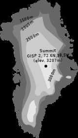
 The Greenland ice sheet is 3 kilometres (1.9 mi) thick and broad enough to blanket an area the size of Mexico. The ice is so massive that its weight presses the bedrock of Greenland below sea level and is so all-concealing that not until recently did scientists discover that Greenland might actually be three islands.
It is thought that before the Ice Age
Greenland had mountainous edges, and a lowland (and probably very dry) center which drained to the sea by one big river flowing out westwards past where Disko Island
is now.
There is concern about sea level rise caused by ice loss (melt and glaciers falling into the sea) on Greenland. Between 1997 and 2003 ice loss was 68 km3/a, compared to about 60 km3/a for 1993/4-1998/9. Half of the increase was from higher summer melting, with the rest caused by velocities of some glaciers exceeding those needed to balance upstream snow accumulation
(Krabill et al., L24402, GRL 2004). A complete loss of ice on Greenland would cause a sea level rise of as much as 6.4 metres (21 ft).
Researchers at NASA
's Jet Propulsion Laboratory
and the University of Kansas
reported in February 2006 that the glaciers are melting twice as fast as they were five years ago. By 2005, Greenland was beginning to lose more ice volume than anyone expected – an annual loss of up to 52 cubic miles or 217 km³ per year, according to more recent satellite gravity measurements released by JPL.
Between 1991 and 2006, monitoring of the weather at one location (Swiss Camp) found that the average winter temperature had risen almost 10 F-change.
However, a map of Greenland's Rate of change in Ice Sheet Height shows something different, since glacier is melting at the border but growing up at its center.
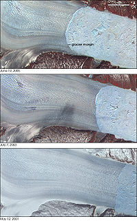
Recently, Greenland's three largest outlet glaciers have started moving faster, satellite data show. These are the Jakobshavn Isbræ
at Ilulissat on the western edge of Greenland, and the Kangerdlugssuaq
and Helheim
glaciers on the eastern edge of Greenland. The two latter accelerated greatly during the years 2004-2005, but returned to pre-2004 velocities in 2006. The accelerating ice flow has been accompanied by a dramatic increase in seismic activity. In March 2006, researchers at Harvard University
and the Lamont-Doherty Earth Observatory
at Columbia University
reported that the glaciers now generate swarms of earthquakes up to magnitude 5.0.
The retreat of Greenland's ice is revealing islands that were thought to be part of the mainland. In September 2005 Dennis Schmitt
discovered an island 400 miles (644 km) north of the Arctic Circle in eastern Greenland which he named Uunartoq Qeqertoq
, Inuit
for "warming island".
, the points that are farther north, south, east or west than any other location.
Greenland (nation)
Greenland (island)
is the largest town - and the capital - with roughly one third of the country's urban population. Sisimiut
with approximately 5,500 inhabitants is the second largest town, while Ilulissat
is number three with ca. 5,000 inhabitants.
Greenland
Greenland is an autonomous country within the Kingdom of Denmark, located between the Arctic and Atlantic Oceans, east of the Canadian Arctic Archipelago. Though physiographically a part of the continent of North America, Greenland has been politically and culturally associated with Europe for...
is located between the Arctic Ocean
Arctic Ocean
The Arctic Ocean, located in the Northern Hemisphere and mostly in the Arctic north polar region, is the smallest and shallowest of the world's five major oceanic divisions...
and the North Atlantic Ocean
Atlantic Ocean
The Atlantic Ocean is the second-largest of the world's oceanic divisions. With a total area of about , it covers approximately 20% of the Earth's surface and about 26% of its water surface area...
, northeast of Canada
Canada
Canada is a North American country consisting of ten provinces and three territories. Located in the northern part of the continent, it extends from the Atlantic Ocean in the east to the Pacific Ocean in the west, and northward into the Arctic Ocean...
and northwest of Iceland
Iceland
Iceland , described as the Republic of Iceland, is a Nordic and European island country in the North Atlantic Ocean, on the Mid-Atlantic Ridge. Iceland also refers to the main island of the country, which contains almost all the population and almost all the land area. The country has a population...
. Greenland has no land boundaries and 44,087 km of coastline. A sparse population is confined to small settlements along the coast. Greenland possesses the world's second largest ice sheet
Ice sheet
An ice sheet is a mass of glacier ice that covers surrounding terrain and is greater than 50,000 km² , thus also known as continental glacier...
.
Greenland sits atop the Greenland plate
Greenland Plate
The Greenland Plate is a supposed tectonic plate bounded to the west by Nares Strait, a probable transform fault, on the southwest by the Ungava transform underlying Davis Strait, on the southeast by the Mid-Atlantic Ridge, and the northeast by the Gakkel Ridge, with its northwest border is still...
, a subplate of the North American plate
North American Plate
The North American Plate is a tectonic plate covering most of North America, Greenland, Cuba, Bahamas, and parts of Siberia, Japan and Iceland. It extends eastward to the Mid-Atlantic Ridge and westward to the Chersky Range in eastern Siberia. The plate includes both continental and oceanic crust...
. The Greenland craton
Craton
A craton is an old and stable part of the continental lithosphere. Having often survived cycles of merging and rifting of continents, cratons are generally found in the interiors of tectonic plates. They are characteristically composed of ancient crystalline basement rock, which may be covered by...
is made up of some of the oldest rocks on the face of the earth. The Isua greenstone belt
Isua greenstone belt
The Isua Greenstone Belt is an Archean greenstone belt in southwestern Greenland. The belt is aged between 3.7 and 3.8 Ga, making it among the oldest rock in the world. The belt contains variably metamorphosed mafic volcanic and sedimentary rocks...
in southwestern Greenland contains the oldest known rocks on Earth dated at 3.7-3.8 Billion years old.
The vegetation is generally sparse, with the only patch of forested land being found in Nanortalik Municipality in the extreme south near Cape Farewell
Cape Farewell, Greenland
Cape Farewell , is a headland on the southern shore of Egger Island, Greenland. Located at it is the southernmost extent of Greenland, projecting out into the North Atlantic Ocean and the Labrador Sea on the same latitude as Stockholm and the Scottish Shetland Islands. Egger and the associated...
.
The climate
Climate
Climate encompasses the statistics of temperature, humidity, atmospheric pressure, wind, rainfall, atmospheric particle count and other meteorological elemental measurements in a given region over long periods...
is arctic
Polar climate
Regions with a polar climate are characterized by a lack of warm summers . Regions with polar climate cover over 20% of the Earth. The sun shines 24 hours in the summer, and barely ever shines at all in the winter...
to subarctic
Subarctic climate
The subarctic climate is a climate characterized by long, usually very cold winters, and short, cool to mild summers. It is found on large landmasses, away from the moderating effects of an ocean, generally at latitudes from 50° to 70°N poleward of the humid continental climates...
with cool summers and cold winters. The terrain is mostly a flat but gradually sloping icecap that covers all land except for a narrow, mountainous, barren, rocky coast. The lowest elevation is sea level
Sea level
Mean sea level is a measure of the average height of the ocean's surface ; used as a standard in reckoning land elevation...
and the highest elevation is the summit of Gunnbjørn Fjeld, the highest point in the Arctic
Arctic
The Arctic is a region located at the northern-most part of the Earth. The Arctic consists of the Arctic Ocean and parts of Canada, Russia, Greenland, the United States, Norway, Sweden, Finland, and Iceland. The Arctic region consists of a vast, ice-covered ocean, surrounded by treeless permafrost...
at 3694 metres (12,119.4 ft). The northernmost point of the Island of Greenland is Cape Morris Jesup
Cape Morris Jesup
Cape Morris Jesup is the northernmost point of mainland Greenland at and is 711.8 km from the geographic North Pole...
, discovered by Admiral Robert Peary
Robert Peary
Robert Edwin Peary, Sr. was an American explorer who claimed to have been the first person, on April 6, 1909, to reach the geographic North Pole...
in 1909. Natural resource
Natural resource
Natural resources occur naturally within environments that exist relatively undisturbed by mankind, in a natural form. A natural resource is often characterized by amounts of biodiversity and geodiversity existent in various ecosystems....
s include zinc
Zinc
Zinc , or spelter , is a metallic chemical element; it has the symbol Zn and atomic number 30. It is the first element in group 12 of the periodic table. Zinc is, in some respects, chemically similar to magnesium, because its ion is of similar size and its only common oxidation state is +2...
, lead
Lead
Lead is a main-group element in the carbon group with the symbol Pb and atomic number 82. Lead is a soft, malleable poor metal. It is also counted as one of the heavy metals. Metallic lead has a bluish-white color after being freshly cut, but it soon tarnishes to a dull grayish color when exposed...
, iron
Iron
Iron is a chemical element with the symbol Fe and atomic number 26. It is a metal in the first transition series. It is the most common element forming the planet Earth as a whole, forming much of Earth's outer and inner core. It is the fourth most common element in the Earth's crust...
ore, coal
Coal
Coal is a combustible black or brownish-black sedimentary rock usually occurring in rock strata in layers or veins called coal beds or coal seams. The harder forms, such as anthracite coal, can be regarded as metamorphic rock because of later exposure to elevated temperature and pressure...
, molybdenum
Molybdenum
Molybdenum , is a Group 6 chemical element with the symbol Mo and atomic number 42. The name is from Neo-Latin Molybdaenum, from Ancient Greek , meaning lead, itself proposed as a loanword from Anatolian Luvian and Lydian languages, since its ores were confused with lead ores...
, gold
Gold
Gold is a chemical element with the symbol Au and an atomic number of 79. Gold is a dense, soft, shiny, malleable and ductile metal. Pure gold has a bright yellow color and luster traditionally considered attractive, which it maintains without oxidizing in air or water. Chemically, gold is a...
, platinum
Platinum
Platinum is a chemical element with the chemical symbol Pt and an atomic number of 78. Its name is derived from the Spanish term platina del Pinto, which is literally translated into "little silver of the Pinto River." It is a dense, malleable, ductile, precious, gray-white transition metal...
, uranium
Uranium
Uranium is a silvery-white metallic chemical element in the actinide series of the periodic table, with atomic number 92. It is assigned the chemical symbol U. A uranium atom has 92 protons and 92 electrons, of which 6 are valence electrons...
, fish
Fish
Fish are a paraphyletic group of organisms that consist of all gill-bearing aquatic vertebrate animals that lack limbs with digits. Included in this definition are the living hagfish, lampreys, and cartilaginous and bony fish, as well as various extinct related groups...
, seals, and whale
Whale
Whale is the common name for various marine mammals of the order Cetacea. The term whale sometimes refers to all cetaceans, but more often it excludes dolphins and porpoises, which belong to suborder Odontoceti . This suborder also includes the sperm whale, killer whale, pilot whale, and beluga...
s.
Area
total:
2,175,600 km²
land:
2,175,600 km² (341,700 km² ice-free, 1,833,900 km² ice-covered) (est.)
Maritime claims:
exclusive fishing zone:
200 nmi (370.4 km; 230.2 mi)
territorial sea:
3 nmi (5.6 km; 3.5 mi)
Land use
arable land:
approximately 0% ; some land is used to grow silage
Silage
Silage is fermented, high-moisture fodder that can be fed to ruminants or used as a biofuel feedstock for anaerobic digesters. It is fermented and stored in a process called ensiling or silaging, and is usually made from grass crops, including corn , sorghum or other cereals, using the entire...
.
permanent crops:
approximately 0%
permanent pastures:
1%
forests and woodland:
approximately 0% ; there is a forest in Nanortalik
Nanortalik
Nanortalik is a town in the Kujalleq municipality in southern Greenland. With 1,448 inhabitants in 2010, it is the tenth-largest town in the country. The name Nanortalik means "place of polar bears" or "place where the polar bears go" .- History :...
municipality.
other:
99% (1993 est.)
Total population 56,000 inhabitants of which ca. 15,000 lives in the capital Nuuk.
Environment - current issues
Protection of the Arctic environment; climatic change; pollution of the food chain; preservation of the InuitInuit
The Inuit are a group of culturally similar indigenous peoples inhabiting the Arctic regions of Canada , Denmark , Russia and the United States . Inuit means “the people” in the Inuktitut language...
traditional way of life, including whaling
Whaling
Whaling is the hunting of whales mainly for meat and oil. Its earliest forms date to at least 3000 BC. Various coastal communities have long histories of sustenance whaling and harvesting beached whales...
; excessive hunting of endangered species (walrus, polar bears, narwhal, beluga whale and several sea birds) - Greenland participates actively in Inuit Circumpolar Council (ICC).
Climate change
It is thought that before the Ice Age
Ice age
An ice age or, more precisely, glacial age, is a generic geological period of long-term reduction in the temperature of the Earth's surface and atmosphere, resulting in the presence or expansion of continental ice sheets, polar ice sheets and alpine glaciers...
Greenland had mountainous edges, and a lowland (and probably very dry) center which drained to the sea by one big river flowing out westwards past where Disko Island
Disko Island
Disko Island is a large island in Baffin Bay, off the west coast of Greenland. It has an area of , making it the second largest island of Greenland and one of the 100 largest islands in the world...
is now.
There is concern about sea level rise caused by ice loss (melt and glaciers falling into the sea) on Greenland. Between 1997 and 2003 ice loss was 68 km3/a, compared to about 60 km3/a for 1993/4-1998/9. Half of the increase was from higher summer melting, with the rest caused by velocities of some glaciers exceeding those needed to balance upstream snow accumulation
Glacier mass balance
Crucial to the survival of a glacier is its mass balance, the difference between accumulation and ablation . Climate change may cause variations in both temperature and snowfall, causing changes in mass balance. Changes in mass balance control a glacier's long term behavior and is the most...
(Krabill et al., L24402, GRL 2004). A complete loss of ice on Greenland would cause a sea level rise of as much as 6.4 metres (21 ft).
Researchers at NASA
NASA
The National Aeronautics and Space Administration is the agency of the United States government that is responsible for the nation's civilian space program and for aeronautics and aerospace research...
's Jet Propulsion Laboratory
Jet Propulsion Laboratory
Jet Propulsion Laboratory is a federally funded research and development center and NASA field center located in the San Gabriel Valley area of Los Angeles County, California, United States. The facility is headquartered in the city of Pasadena on the border of La Cañada Flintridge and Pasadena...
and the University of Kansas
University of Kansas
The University of Kansas is a public research university and the largest university in the state of Kansas. KU campuses are located in Lawrence, Wichita, Overland Park, and Kansas City, Kansas with the main campus being located in Lawrence on Mount Oread, the highest point in Lawrence. The...
reported in February 2006 that the glaciers are melting twice as fast as they were five years ago. By 2005, Greenland was beginning to lose more ice volume than anyone expected – an annual loss of up to 52 cubic miles or 217 km³ per year, according to more recent satellite gravity measurements released by JPL.
Between 1991 and 2006, monitoring of the weather at one location (Swiss Camp) found that the average winter temperature had risen almost 10 F-change.
However, a map of Greenland's Rate of change in Ice Sheet Height shows something different, since glacier is melting at the border but growing up at its center.
Recently, Greenland's three largest outlet glaciers have started moving faster, satellite data show. These are the Jakobshavn Isbræ
Jakobshavn Isbræ
Jakobshavn Isbræ, also known as the Jakobshavn Glacier and Sermeq Kujalleq is a large outlet glacier in West Greenland. It is located near the Greenlandic town of Ilulissat and ends at the sea in the Ilulissat Icefjord....
at Ilulissat on the western edge of Greenland, and the Kangerdlugssuaq
Kangerdlugssuaq Glacier
Kangerdlugssuaq Glacier is the largest glacier on the east coast of the Greenland ice sheet. It flows into the Denmark Strait.-External links:...
and Helheim
Helheim Glacier
Helheim Glacier is one of Greenland's largest outlet glaciers. It accelerated from per year in 2000 to per year in 2005. Like many of Greenland's outlet glaciers it is the site of glacial earthquakes.-External links:...
glaciers on the eastern edge of Greenland. The two latter accelerated greatly during the years 2004-2005, but returned to pre-2004 velocities in 2006. The accelerating ice flow has been accompanied by a dramatic increase in seismic activity. In March 2006, researchers at Harvard University
Harvard University
Harvard University is a private Ivy League university located in Cambridge, Massachusetts, United States, established in 1636 by the Massachusetts legislature. Harvard is the oldest institution of higher learning in the United States and the first corporation chartered in the country...
and the Lamont-Doherty Earth Observatory
Lamont-Doherty Earth Observatory
The Lamont–Doherty Earth Observatory is a research unit of Columbia University located on a campus in Palisades, N.Y., north of Manhattan on the Hudson River.- History :...
at Columbia University
Columbia University
Columbia University in the City of New York is a private, Ivy League university in Manhattan, New York City. Columbia is the oldest institution of higher learning in the state of New York, the fifth oldest in the United States, and one of the country's nine Colonial Colleges founded before the...
reported that the glaciers now generate swarms of earthquakes up to magnitude 5.0.
The retreat of Greenland's ice is revealing islands that were thought to be part of the mainland. In September 2005 Dennis Schmitt
Dennis Schmitt
Dennis Schmitt , is a veteran explorer from UC Berkeley who, in 2005, discovered a new island formed by the retreat of an ice shelf in East Greenland...
discovered an island 400 miles (644 km) north of the Arctic Circle in eastern Greenland which he named Uunartoq Qeqertoq
Uunartoq Qeqertoq
Uunartoq Qeqertaq, Greenlandic for "The Warming Island", is an island discovered in September 2005 by American explorer Dennis Schmitt off the east central coast of Greenland, north of the Arctic Circle...
, Inuit
Inuit language
The Inuit language is traditionally spoken across the North American Arctic and to some extent in the subarctic in Labrador. The related Yupik languages are spoken in western and southern Alaska and Russian Far East, particularly the Diomede Islands, but is severely endangered in Russia today and...
for "warming island".
Extreme points
This is a list of the extreme points of GreenlandGreenland
Greenland is an autonomous country within the Kingdom of Denmark, located between the Arctic and Atlantic Oceans, east of the Canadian Arctic Archipelago. Though physiographically a part of the continent of North America, Greenland has been politically and culturally associated with Europe for...
, the points that are farther north, south, east or west than any other location.
Greenland (nation)
- Northernmost Point — Kaffeklubben IslandKaffeklubben IslandKaffeklubben Island or The Coffee Club Island is a small island lying off the northern tip of Greenland. It is the northernmost point of land on Earth....
(83°40'N) - the northernmost permanent land in the world. There are also some shifting gravel bars that lie north of Kaffeklubben, the most famous being OodaaqOodaaqOodaaq or Oodap Qeqert is a bank of gravel and silt northeast of Greenland that has been considered by some to be the most northerly point of land on earth....
. - Southernmost Point — unnamed islet 2.3 km south of Cape FarewellCape Farewell, GreenlandCape Farewell , is a headland on the southern shore of Egger Island, Greenland. Located at it is the southernmost extent of Greenland, projecting out into the North Atlantic Ocean and the Labrador Sea on the same latitude as Stockholm and the Scottish Shetland Islands. Egger and the associated...
, Egger Island (59°44'N) - Westernmost Point — Cape AlexanderCape Alexander, GreenlandCape Alexander is the westernmost point in Greenland....
(73°08'W) - Easternmost Point — NordostrundingenNordostrundingenNordostrundingen , is a headland located at the northeastern end of the island of Greenland. At 11°19'W it is the most easterly point of land in both the Americas...
, GreenlandGreenlandGreenland is an autonomous country within the Kingdom of Denmark, located between the Arctic and Atlantic Oceans, east of the Canadian Arctic Archipelago. Though physiographically a part of the continent of North America, Greenland has been politically and culturally associated with Europe for...
(11°19'W)
Greenland (island)
- Northernmost Point — Cape Morris JesupCape Morris JesupCape Morris Jesup is the northernmost point of mainland Greenland at and is 711.8 km from the geographic North Pole...
(83°39'N) - Southernmost Point — Peninsula near NanortalikNanortalikNanortalik is a town in the Kujalleq municipality in southern Greenland. With 1,448 inhabitants in 2010, it is the tenth-largest town in the country. The name Nanortalik means "place of polar bears" or "place where the polar bears go" .- History :...
- Westernmost Point — Cape AlexanderCape Alexander, GreenlandCape Alexander is the westernmost point in Greenland....
(73°08'W) - Easternmost Point — NordostrundingenNordostrundingenNordostrundingen , is a headland located at the northeastern end of the island of Greenland. At 11°19'W it is the most easterly point of land in both the Americas...
, GreenlandGreenlandGreenland is an autonomous country within the Kingdom of Denmark, located between the Arctic and Atlantic Oceans, east of the Canadian Arctic Archipelago. Though physiographically a part of the continent of North America, Greenland has been politically and culturally associated with Europe for...
(11°19'W)
Towns
Greenland has 18 towns - settlements with more than 500 inhabitants. NuukNuuk
Nuuk, is the capital of Greenland, the northernmost capital in North America and the largest city in Greenland. Located in the Nuup Kangerlua fjord, the city lies on the eastern shore of the Labrador Sea and on the west coast of Sermersooq. Nuuk is the largest cultural and economic center in...
is the largest town - and the capital - with roughly one third of the country's urban population. Sisimiut
Sisimiut
Sisimiut is a town in central-western Greenland, located on the coast of Davis Strait, approximately north of Nuuk. It is the administrative center of the Qeqqata Municipality and the second-largest town in Greenland, with a population of 5,460 people as of 2010. The site of the present-day town...
with approximately 5,500 inhabitants is the second largest town, while Ilulissat
Ilulissat
Ilulissat is a town in the Qaasuitsup municipality in western Greenland, located approximately north of the Arctic Circle. With the population of 4,546 as of 2010, it is the third-largest settlement in Greenland, after Nuuk and Sisimiut....
is number three with ca. 5,000 inhabitants.
- AasiaatAasiaatAasiaat is a town in the Qaasuitsup municipality in western Greenland. Located in the heart of Aasiaat Archipelago at the southern end of Disko Bay. With a population of 3,005 as of 2010, it is Greenland's fifth-largest town.-Etymology:...
- IlulissatIlulissatIlulissat is a town in the Qaasuitsup municipality in western Greenland, located approximately north of the Arctic Circle. With the population of 4,546 as of 2010, it is the third-largest settlement in Greenland, after Nuuk and Sisimiut....
- IttoqqortoormiitIttoqqortoormiitIttoqqortoormiit is a settlement in the Sermersooq municipality in eastern Greenland. Its population is 469 as of 2010.The Danish name Scoresbysund derives from the name of the Arctic explorer and whaler William Scoresby, who was the first to map the area in 1822. The Greenlandic name...
- KangaatsiaqKangaatsiaqKangaatsiaq is a town located at the southern end of the Qaasuitsup municipality in western Greenland. The town received town status as recently as 1986, though as a settlement it has existed much longer. It has 586 inhabitants as of 2010...
- ManiitsoqManiitsoqManiitsoq is a town in the Qeqqata municipality in western Greenland. With 2,784 inhabitants as of 2010, it is the sixth-largest town in Greenland...
- NanortalikNanortalikNanortalik is a town in the Kujalleq municipality in southern Greenland. With 1,448 inhabitants in 2010, it is the tenth-largest town in the country. The name Nanortalik means "place of polar bears" or "place where the polar bears go" .- History :...
- NarsaqNarsaqNarsaq is a town in the Kujalleq municipality in southern Greenland. The name Narsaq is Greenlandic for "plain", referring to the beautiful plain on the shore of Tunulliarfik Fjord where the town is located.- History :...
- NarsarsuaqNarsarsuaqNarsarsuaq is a settlement in the Kujalleq municipality in southern Greenland. It had 158 inhabitants in 2010. There is a thriving tourism industry in and around Narsarsuaq, whose attractions include a great diversity of wildlife, gemstones, tours to glaciers, and an airfield museum...
- NuukNuukNuuk, is the capital of Greenland, the northernmost capital in North America and the largest city in Greenland. Located in the Nuup Kangerlua fjord, the city lies on the eastern shore of the Labrador Sea and on the west coast of Sermersooq. Nuuk is the largest cultural and economic center in...
- PaamiutPaamiutPaamiut is a town in the Sermersooq municipality in southwestern Greenland. The name of the town means "they who reside by the mouth" in Greenlandic.- Geography :...
- QaanaaqQaanaaqQaanaaq is the main town in the northern part of the Qaasuitsup municipality in northwestern Greenland. It is one of the northernmost towns in the world. The inhabitants of Qaanaaq speak the West Greenlandic language and many also speak Inuktun. The town has a population of 626 as of 2010...
- QaqortoqQaqortoqQaqortoq is a town in the Kujalleq municipality in southern Greenland. With a population of 3,230 as of 2011, it is the most populous town in southern Greenland, and the fourth-largest town in the country. The name is western Greenlandic and means "[the] white [one]".- History :The area around...
- QasigiannguitQasigiannguitQasigiannguit is a town located on the southeastern shore of Disko Bay, in the Qaasuitsup municipality in western Greenland. With 1,253 inhabitants as of 2010, it is the twelfth-largest town in Greenland. The main industry is shrimp and halibut fishing....
- QeqertarsuaqQeqertarsuaqQeqertarsuaq is a port and a town in Qaasuitsup municipality, located on the south coast of Qeqertarsuaq Island, an island on the west coast of Greenland. Founded in 1773, it is home to a campus of the University of Copenhagen...
- SisimiutSisimiutSisimiut is a town in central-western Greenland, located on the coast of Davis Strait, approximately north of Nuuk. It is the administrative center of the Qeqqata Municipality and the second-largest town in Greenland, with a population of 5,460 people as of 2010. The site of the present-day town...
- TasiilaqTasiilaqTasiilaq is a town in the Sermersooq municipality in southeastern Greenland. With 1,930 inhabitants as of 2010, it is the most populous community on the eastern coast, and the seventh-largest town in Greenland...
- UpernavikUpernavikUpernavik is a small town in the Qaasuitsup municipality in northwestern Greenland, located on a small island of the same name. With 1,129 inhabitants as of 2010, it is the thirteenth-largest town in Greenland. Due to the small size of the settlement, everything is within walking distance...
- UummannaqUummannaqUummannaq is a town in the Qaasuitsup municipality, in northwestern Greenland. With 1,299 inhabitants as of 2010, it is the eleventh-largest town in Greenland, and is home to the country's most northerly ferry terminal...
External links
- www.geus.dk Geological map of Greenland from the Geological Survey of Denmark and Greenland ( GEUS).