

Ocean surface topography
Encyclopedia

Topographic map
A topographic map is a type of map characterized by large-scale detail and quantitative representation of relief, usually using contour lines in modern mapping, but historically using a variety of methods. Traditional definitions require a topographic map to show both natural and man-made features...
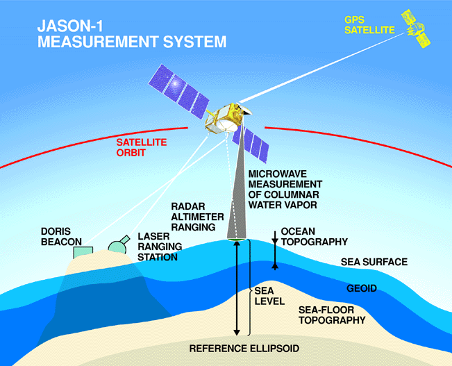
. These variations, called "ocean surface topography" or "dynamic sea surface topography" are mapped using measurements of sea surface height relative to Earth's geoid
Geoid
The geoid is that equipotential surface which would coincide exactly with the mean ocean surface of the Earth, if the oceans were in equilibrium, at rest , and extended through the continents . According to C.F...
. Earth's geoid is a calculated surface of equal gravitational potential energy and represents the shape the sea surface would be if the ocean were not in motion.
The height variations of ocean surface topography can be as much as two meters and are influenced by ocean circulation, ocean temperature, and salinity.
Ocean surface topography is used to map ocean currents
Ocean current
An ocean current is a continuous, directed movement of ocean water generated by the forces acting upon this mean flow, such as breaking waves, wind, Coriolis effect, cabbeling, temperature and salinity differences and tides caused by the gravitational pull of the Moon and the Sun...
, which move around the ocean's "hills" and "valleys" in predictable ways. A clockwise sense of rotation is found around "hills" in the northern hemisphere and "valleys" in the southern hemisphere. This is because of the Coriolis effect
Coriolis effect
In physics, the Coriolis effect is a deflection of moving objects when they are viewed in a rotating reference frame. In a reference frame with clockwise rotation, the deflection is to the left of the motion of the object; in one with counter-clockwise rotation, the deflection is to the right...
. Conversely, a counterclockwise sense of rotation is found around "valleys" in the northern hemisphere and "hills" in the southern hemisphere.
Ocean surface topography is also used to understand how the ocean moves heat around the globe, a critical component of Earth's climate
Climate
Climate encompasses the statistics of temperature, humidity, atmospheric pressure, wind, rainfall, atmospheric particle count and other meteorological elemental measurements in a given region over long periods...
, and for monitoring changes in global sea level.
Ship
Since the end of the age of sail a ship has been any large buoyant marine vessel. Ships are generally distinguished from boats based on size and cargo or passenger capacity. Ships are used on lakes, seas, and rivers for a variety of activities, such as the transport of people or goods, fishing,...
-going measurement
Measurement
Measurement is the process or the result of determining the ratio of a physical quantity, such as a length, time, temperature etc., to a unit of measurement, such as the metre, second or degree Celsius...
s of temperature
Temperature
Temperature is a physical property of matter that quantitatively expresses the common notions of hot and cold. Objects of low temperature are cold, while various degrees of higher temperatures are referred to as warm or hot...
and salinity
Salinity
Salinity is the saltiness or dissolved salt content of a body of water. It is a general term used to describe the levels of different salts such as sodium chloride, magnesium and calcium sulfates, and bicarbonates...
at depth. However, since 1992, a series of satellite
Satellite
In the context of spaceflight, a satellite is an object which has been placed into orbit by human endeavour. Such objects are sometimes called artificial satellites to distinguish them from natural satellites such as the Moon....
altimetry
Altimeter
An altimeter is an instrument used to measure the altitude of an object above a fixed level. The measurement of altitude is called altimetry, which is related to the term bathymetry, the measurement of depth underwater.-Pressure altimeter:...
missions, beginning with TOPEX/Poseidon
TOPEX/Poseidon
Launched in 1992, TOPEX/Poseidon was a joint satellite mission between NASA, the U.S. space agency, and CNES, the French space agency, to map ocean surface topography. The first major oceanographic research vessel to sail into space, TOPEX/Poseidon helped revolutionize oceanography by proving the...
and continued with Jason-1 and the Ocean Surface Topography Mission
Ocean Surface Topography Mission
The Ocean Surface Topography Mission on the Jason-2 satellite is an international Earth observation satellite mission that continues the sea surface height measurements begun in 1992 by the joint NASA/CNES TOPEX/Poseidon mission and followed by the NASA/CNES Jason-1 mission launched in 2001.Like...
on the Jason-2 satellite have measured sea surface height directly. By combining these measurements with gravity measurements from NASA's Grace
Gravity Recovery and Climate Experiment
The Gravity Recovery And Climate Experiment , a joint mission of NASA and the German Space Agency, has been making detailed measurements of Earth's gravity field since its launch in March 2002....
mission, scientists can determine sea surface topography to within a few centimeters.
A new satellite mission called the Surface Water Ocean Topography Mission
Surface Water Ocean Topography Mission
The Surface Water Ocean Topography Mission is a proposed NASA mission to make the first global survey of Earth’s surface water. It is one of 15 missions that the 2007 National Research Council’s decadal survey of Earth science recommends NASA implement in the coming decade.SWOT is being developed...
has been proposed to make the first global survey of the topography of all of Earth's surface water--the ocean, lakes and rivers. This study is aimed to provide a comprehensive view of Earth’s freshwater bodies from space and more much detailed measurements of the ocean surface than ever before.