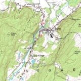
See Also

Topography

Topography is a general term in geography Geography

Geography is the study of the Earth's features and of the distribution of life on the earth, including ... 

, derived from the Greek "topos" and "graphein" , and refers to the lie of the land Landform

A landform comprises a geomorphological [i] unit. ... 

, or various other characteristics of Physical geography Physical geography

Physical Geography looks at the natural environment, e.g.... 

 in a region; this is usually expressed in terms of the elevation Elevation

The elevation of a geographic [i] location [i] is its height above a fixed reference point, oft ... 

, slope Slope

The slope or the gradient is commonly used to describe the measurement of the steepness, incline o... 

, and orientation of terrain features. The understanding of these features is an integral aspect of geography, encompassing the practice of cartography Cartography

Cartography or mapmaking is the study and practice of making map [i]s or globe [i]s. ... 

, surveying Surveying

Surveying is the technique and science of accurately determining the terrestrial or three-dimensional sp... 

, and GIS Geographic Information System

A Geographic Information System is a system for creating, storing, analyzing and managing spatial data ... 

. The topography of an area often has a great influence on its [weather] and sometimes on [climate]. Maps are the most common source of topographic information.

Discussions

  Discussion Features

   Ask a question about 'Topography'

   Start a new discussion about 'Topography'

   Answer questions about 'Topography'

   'Topography' discussion forum


Encyclopedia


Topography is a general term in geography Geography

Geography is the study of the Earth's features and of the distribution of life on the earth, including ... 

, derived from the Greek "topos" and "graphein" , and refers to the lie of the land Landform

A landform comprises a geomorphological [i] unit. ... 

, or various other characteristics of Physical geography Physical geography

Physical Geography looks at the natural environment, e.g.... 

 in a region; this is usually expressed in terms of the elevation Elevation

The elevation of a geographic [i] location [i] is its height above a fixed reference point, oft ... 

, slope Slope

The slope or the gradient is commonly used to describe the measurement of the steepness, incline o... 

, and orientation of terrain features. The understanding of these features is an integral aspect of geography, encompassing the practice of cartography Cartography

Cartography or mapmaking is the study and practice of making map [i]s or globe [i]s. ... 

, surveying Surveying

Surveying is the technique and science of accurately determining the terrestrial or three-dimensional sp... 

, and GIS Geographic Information System

A Geographic Information System is a system for creating, storing, analyzing and managing spatial data ... 

. The topography of an area often has a great influence on its [weather] and sometimes on [climate].

Maps are the most common source of topographic information.

The term "relief", meaning "projection or standing out from the general surface", is often used to refer to the third dimension Dimension

In common usage, a dimension is a parameter [i] or measurement [i] required to define the characteristi ... 

 of a map Map

A map is a simplified depiction of a space [i], a navigational aid which highlights relations between ob ... 

 whether in actuality , or drawn, as with contours Contour line

A contour line for a function of two variables is a curve [i] connecting points where the function has ... 

, hachures, shading or colour Color

Color or colour is the visual perceptual property corresponding in humans to the categories... 

s of the territory it describes. Most 18th 18th century

As a means of recording the passage of time [i], the 18th century refers to the century [i] that las ... 

 and early 19th century 19th century

The 19th century lasted from 1801 [i] through 1900 [i] in the Gregorian calendar [i].
... 

 national surveys did not record relief across the entire area of coverage, calculating only spot elevations at survey points. The United States Geological Survey United States Geological Survey

border="1" cellpadding="2" cellspacing="0">
... 

  topographical survey maps included contour representation of relief, and so maps that show relief, especially with exact representation of elevation, came to be called topographic map Topographic map

Topographic maps, also called contour maps, topo maps or topo quads, are map [i]s that show topography [i] ... 

s in the United States United States

The United States of America, also known as the United States, the U.S., the U.S.A., a... 

, and the usage has spread internationally.


The understanding of topography is critical for a number of reasons.

Firstly, it is usually the topograhy of a place that originally determines its suitability for human settlement: settlement often leads to the creation of a family; and to the arrivel of another, separate family; and so on. Towns and cities are where they are more because of the lie of the land than for any other reason.

In terms of environment Natural environment

The natural environment comprises all living and non-living things that occur naturally [i] on Earth [i] ... 

al quality, agriculture Agriculture

Farming redirects here. For Farming in computer games, see Farmer [i].
... 

, and hydrology Hydrology

Hydrology is the study of the movement, distribution, and quality of water [i] throughout the Earth, an ... 

, understanding the topography of an area enables the understanding of watershed Drainage basin

A drainage basin is a region of land where water [i] from rain [i] or snow [i]melt drains downhill into... 

 boundaries, drainage Drainage

Drainage is the natural or artificial removal of surface and sub-surface water [i] from a gi ... 

 characteristics, water Water

Water is a taste [i]less, odor [i]less substance that is essential to all known forms of life [i] and i ... 

 movement, and impacts on water quality. Complex arrays of topographic data are used as input parameters for water quality]].

Understanding topography also impinges on soil conservation Soil conservation

Soil conservation is a set of management strategies for prevention of soil [i] being eroded [i]... 

, especially in agriculture. Contour Contour line

A contour line for a function of two variables is a curve [i] connecting points where the function has ... 

 plowing Plough

The plough is a tool [i] used in farming [i] for initial cultivation of soil in preparation for sowing ... 

 is an established practice of enabling sustainable agriculture on sloping land, and is the practice of plowing along topographic lines.

Topography is critical militarily Military

A military or military force has seen many different incarnations throughout time.... 

 because it determines the ability of armed forces Armed forces

The armed forces of a state [i] are its government sponsored defense and fighting forces and organizatio ... 

 to take and hold areas, and to move troops and material into and through areas.

Topography is important in determining weather Weather

Weather is an all-encompassing term used to describe all of the many and varied phenomena [i] that c ... 

 patterns. Two areas in proximity to each other geographically may differ radically in characteristics such as precipitation because of elevation differences or because of a "rain shadow Rain shadow

A rain shadow is a dry region on the surface of the Earth [i] that is leeward [i] or behind a mountain [i] ... 

" effect.

Tectonic Plate tectonics

Plate tectonics is a theory [i] of geology [i] developed to explain the observed evidence for large sca ... 

 processes and erosion Erosion

Erosion is the displacement of solids by the agents of wind, water or ice, by downward or down-slope mo... 

al processes are the determiners of topography. Tectonic processes such as orogenies Orogeny

Orogeny is the process of mountain [i] building, and may be studied as a tectonic structural event, as ... 

 cause land to be elevated, and erosional processes cause land to be worn away to lower elevations.

Alternative view

The essence of Topography is the detailed recording of all the features of a place which may be of significance to the intelligent visitor.

Topography is NOT the mere record of natural geographical features and land forms.

That is the province of geography and the geographer

Topography is also concerned more and principally with the marks and changes wrought and left by previous inhabitants and visitors.

Topographers must be as interested in the local traces of ancient activity such as dwellings, fortifications, work and worship as they are in the geography and geology and any fossils therein.

The first systematic topographer was the English antiquary, John Leland . King Henry VIII gave him a warrant to search all the libraries of monasteries and colleges of the kingdom to rescue the records of ancient writers of England and other nations.

This inspired Leland to record other particulars of the places where the records were kept and which the records mentioned.

In 1546, he wrote that he had so travelled by the sea coasts and the middle parts for six years, that there was

“almost neither cape nor bay, haven, creek or pier, river or confluence of rivers, breaches, washes, lakes, meres, fenny waters, mountains, valleys, moors, heaths, forests, woods, cities, boroughs, castles, principal manor places, monasteries, and colleges, but I have seen them, and noted things very memorable”.

His intention was to make a great map of England and Wales, and to write the first detailed topographical description of them — but he died 1552.

However, his researches laid the foundations on which others were to build: Lambarde's "Perambulation of Kent" , Richard Carew's "Survey of Cornwall" written in the 1590s and George Owen's "Description of Pembrokeshire" , established in the world the science and art of Topography.

The most famous of these topographers then was Camden, who was praised by both Edmund Spenser and Ben Jonson.

The most popular sources of topography and the topographer's work are found in the classic guide books supplemented by maps.

If it is true that the United States Geological Survey which was established on March 3, 1879 called its maps "topographical" because they showed the heights or elevations above sea level then this presumably is why the word "topographical" is confused in the USA with the word "relief" in the context of geography.

As explained above, topography and matters topographical are more to do with the way a human culture exploits a place than with the forces that make the place what it is.

Geography creates a desert. It is a human culture that decides to give it the name of "desert".
Topography examines the culture of that place that arrived at the decision to give that desert that name.

See Camden at

http://66.102.9.104/search?q=cache:x0-Kf_DxEQEJ:www.bartleby.com/213/1506.html+camden+topographer&hl=en&gl=uk&ct=clnk&cd=1

See also

  • Geomorphology Geomorphology

    Geomorphology is the study of landforms [i], including their origin and evolution, and the processes tha ... 

  • Landform Landform

    A landform comprises a geomorphological [i] unit. ... 

  • bathymetry Bathymetry

    Bathymetry is the underwater equivalent to altimetry [i]. ...