

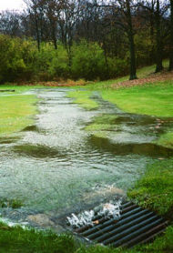
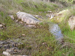
Surface runoff
Encyclopedia
Water
Water is a chemical substance with the chemical formula H2O. A water molecule contains one oxygen and two hydrogen atoms connected by covalent bonds. Water is a liquid at ambient conditions, but it often co-exists on Earth with its solid state, ice, and gaseous state . Water also exists in a...
from rain
Rain
Rain is liquid precipitation, as opposed to non-liquid kinds of precipitation such as snow, hail and sleet. Rain requires the presence of a thick layer of the atmosphere to have temperatures above the melting point of water near and above the Earth's surface...
, meltwater
Meltwater
Meltwater is the water released by the melting of snow or ice, including glacial ice and ice shelfs over oceans. Meltwater is often found in the ablation zone of glaciers, where the rate of snow cover is reducing...
, or other sources flows over the land. This is a major component of the water cycle
Water cycle
The water cycle, also known as the hydrologic cycle or H2O cycle, describes the continuous movement of water on, above and below the surface of the Earth. Water can change states among liquid, vapor, and solid at various places in the water cycle...
. Runoff that occurs on surfaces before reaching a channel
Channel (geography)
In physical geography, a channel is the physical confine of a river, slough or ocean strait consisting of a bed and banks.A channel is also the natural or human-made deeper course through a reef, sand bar, bay, or any shallow body of water...
is also called a nonpoint source
Nonpoint source pollution
Nonpoint source pollution refers to both water and air pollution from diffuse sources. Nonpoint source water pollution affects a water body from sources such as polluted runoff from agricultural areas draining into a river, or wind-borne debris blowing out to sea. Nonpoint source air pollution...
. If a nonpoint source contains man-made contaminants, the runoff is called nonpoint source pollution
Nonpoint source pollution
Nonpoint source pollution refers to both water and air pollution from diffuse sources. Nonpoint source water pollution affects a water body from sources such as polluted runoff from agricultural areas draining into a river, or wind-borne debris blowing out to sea. Nonpoint source air pollution...
. A land area which produces runoff that drains to a common point is called a drainage basin
Drainage basin
A drainage basin is an extent or an area of land where surface water from rain and melting snow or ice converges to a single point, usually the exit of the basin, where the waters join another waterbody, such as a river, lake, reservoir, estuary, wetland, sea, or ocean...
. When runoff flows along the ground, it can pick up soil contaminants
Soil contamination
Soil contamination or soil pollution is caused by the presence of xenobiotic chemicals or other alteration in the natural soil environment....
including, but not limited to petroleum
Petroleum
Petroleum or crude oil is a naturally occurring, flammable liquid consisting of a complex mixture of hydrocarbons of various molecular weights and other liquid organic compounds, that are found in geologic formations beneath the Earth's surface. Petroleum is recovered mostly through oil drilling...
, pesticide
Pesticide
Pesticides are substances or mixture of substances intended for preventing, destroying, repelling or mitigating any pest.A pesticide may be a chemical unicycle, biological agent , antimicrobial, disinfectant or device used against any pest...
s, or fertilizer
Fertilizer
Fertilizer is any organic or inorganic material of natural or synthetic origin that is added to a soil to supply one or more plant nutrients essential to the growth of plants. A recent assessment found that about 40 to 60% of crop yields are attributable to commercial fertilizer use...
s that become discharge
Discharge (hydrology)
In hydrology, discharge is the volume rate of water flow, including any suspended solids , dissolved chemical species and/or biologic material , which is transported through a given cross-sectional area...
or nonpoint source pollution.
Generation
Snow
Snowmelt
In hydrology, snowmelt is surface runoff produced from melting snow. It can also be used to describe the period or season during which such runoff is produced. Water produced by snowmelt is an important part of the annual water cycle in many parts of the world, in some cases contributing high...
and glacier
Glacier
A glacier is a large persistent body of ice that forms where the accumulation of snow exceeds its ablation over many years, often centuries. At least 0.1 km² in area and 50 m thick, but often much larger, a glacier slowly deforms and flows due to stresses induced by its weight...
melt occur only in areas cold enough for these to form permanently. Typically snowmelt
Snowmelt
In hydrology, snowmelt is surface runoff produced from melting snow. It can also be used to describe the period or season during which such runoff is produced. Water produced by snowmelt is an important part of the annual water cycle in many parts of the world, in some cases contributing high...
will peak in the spring and glacier melt in the summer, leading to pronounced flow maxima in rivers affected by them. The determining factor of the rate of melting of snow or glaciers is both air temperature and the duration of sunlight. In high mountain regions, streams frequently rise on sunny days and fall on cloudy ones for this reason.
In areas where there is no snow, runoff will come from rainfall. However, not all rainfall will produce runoff because storage from soils can absorb light showers. On the extremely ancient soils of Australia
Australia
Australia , officially the Commonwealth of Australia, is a country in the Southern Hemisphere comprising the mainland of the Australian continent, the island of Tasmania, and numerous smaller islands in the Indian and Pacific Oceans. It is the world's sixth-largest country by total area...
and Southern Africa
Southern Africa
Southern Africa is the southernmost region of the African continent, variably defined by geography or geopolitics. Within the region are numerous territories, including the Republic of South Africa ; nowadays, the simpler term South Africa is generally reserved for the country in English.-UN...
, proteoid root
Proteoid root
Proteoid roots, also known as cluster roots, are plant roots that form clusters of closely spaced short lateral rootlets. They may form a two to five centimetre thick mat just beneath the leaf litter. They enhance nutrient uptake, possibly by chemically modifying the soil environment to improve...
s with their extremely dense networks of root hairs can absorb so much rainwater as to prevent runoff even when substantial amounts of rain fall. In these regions, even on less infertile cracking clay soils
Vertisol
In both the FAO and USA soil taxonomy, a vertisol is a soil in which there is a high content of expansive clay known as montmorillonite that forms deep cracks in drier seasons or years. Alternate shrinking and swelling causes self-mulching, where the soil material consistently mixes itself, causing...
, high amounts of rainfall and potential evaporation are needed to generate any surface runoff, leading to specialised adaptations to extremely variable (usually ephemeral) streams.
Infiltration excess overland flow
This occurs when the rate of rainfall on a surface exceeds the rate at which water can infiltrateInfiltration (hydrology)
Infiltration is the process by which water on the ground surface enters the soil. Infiltration rate in soil science is a measure of the rate at which soil is able to absorb rainfall or irrigation. It is measured in inches per hour or millimeters per hour. The rate decreases as the soil becomes...
the ground, and any depression storage has already been filled. This is called infiltration excess overland flow, Hortonian overland flow (after Robert E. Horton
Robert E. Horton
Robert Elmer Horton was an American ecologist and soil scientist, considered by many to be the father of modern hydrology....
), or unsaturated overland flow. This more commonly occurs in arid
Arid
A region is said to be arid when it is characterized by a severe lack of available water, to the extent of hindering or even preventing the growth and development of plant and animal life...
and semi-arid
Semi-arid
A semi-arid climate or steppe climate describes climatic regions that receive precipitation below potential evapotranspiration, but not extremely...
regions, where rainfall intensities are high and the soil
Soil
Soil is a natural body consisting of layers of mineral constituents of variable thicknesses, which differ from the parent materials in their morphological, physical, chemical, and mineralogical characteristics...
infiltration capacity is reduced because of surface sealing, or in paved areas. This occurs largely in city areas where pavements prevent water infiltration.
Saturation excess overland flow
When the soilSoil
Soil is a natural body consisting of layers of mineral constituents of variable thicknesses, which differ from the parent materials in their morphological, physical, chemical, and mineralogical characteristics...
is saturated and the depression storage filled, and rain continues to fall, the rainfall will immediately produce surface runoff. The level of antecedent soil moisture is one factor affecting the time until soil becomes saturated. This runoff is called saturation excess overland flow or saturated overland flow. It is also known as Hewlettian runoff.
Antecedent soil moisture
Soil retains a degree of moisture after a rainfall. This residual water moisture affects the soil's infiltration capacity. During the next rainfall event, the infiltration capacity will cause the soil to be saturated at a different rate. The higher the level of antecedent soil moisture, the more quickly the soil becomes saturated. Once the soil is saturated, runoff occurs.Subsurface return flow
After water infiltrates the soil on an up-slope portion of a hill, the water may flow laterally through the soil, and exfiltrate (flow out of the soil) closer to a channel. This is called subsurface return flow or throughflowThroughflow
In hydrology, throughflow is the horizontal movement of water in the soil zone. This type of flow must first emerge on land before it enters a body of surface water to be considered throughflow...
.
As it flows, the amount of runoff may be reduced in a number of possible ways: a small portion of it may evapotranspire
Evapotranspiration
Evapotranspiration is a term used to describe the sum of evaporation and plant transpiration from the Earth's land surface to atmosphere. Evaporation accounts for the movement of water to the air from sources such as the soil, canopy interception, and waterbodies...
; water may become temporarily stored in microtopographic depressions; and a portion of it may become run-on
Run-on
In hydrology, run-on refers both to the process whereby surface runoff infiltrates the ground as it flows, and to the portion of runoff that infiltrates. Run-on is common in arid and semi-arid areas with patchy vegetation cover and short but intense thunderstorms...
, which is the infiltration
Infiltration (hydrology)
Infiltration is the process by which water on the ground surface enters the soil. Infiltration rate in soil science is a measure of the rate at which soil is able to absorb rainfall or irrigation. It is measured in inches per hour or millimeters per hour. The rate decreases as the soil becomes...
of runoff as it flows overland. Any remaining surface water eventually flows into a receiving water
Surface water
Surface water is water collecting on the ground or in a stream, river, lake, wetland, or ocean; it is related to water collecting as groundwater or atmospheric water....
body such as a river
River
A river is a natural watercourse, usually freshwater, flowing towards an ocean, a lake, a sea, or another river. In a few cases, a river simply flows into the ground or dries up completely before reaching another body of water. Small rivers may also be called by several other names, including...
, lake
Lake
A lake is a body of relatively still fresh or salt water of considerable size, localized in a basin, that is surrounded by land. Lakes are inland and not part of the ocean and therefore are distinct from lagoons, and are larger and deeper than ponds. Lakes can be contrasted with rivers or streams,...
, estuary
Estuary
An estuary is a partly enclosed coastal body of water with one or more rivers or streams flowing into it, and with a free connection to the open sea....
or ocean
Ocean
An ocean is a major body of saline water, and a principal component of the hydrosphere. Approximately 71% of the Earth's surface is covered by ocean, a continuous body of water that is customarily divided into several principal oceans and smaller seas.More than half of this area is over 3,000...
.
Human influence
Urbanization
Urbanization, urbanisation or urban drift is the physical growth of urban areas as a result of global change. The United Nations projected that half of the world's population would live in urban areas at the end of 2008....
increases surface runoff, by creating more impervious surface
Impervious surface
Impervious surfaces are mainly artificial structures--such as pavements that are covered by impenetrable materials such as asphalt, concrete, brick, and stone--and rooftops...
s such as pavement and buildings, that do not allow percolation
Percolation
In physics, chemistry and materials science, percolation concerns the movement and filtering of fluids through porous materials...
of the water down through the soil to the aquifer
Aquifer
An aquifer is a wet underground layer of water-bearing permeable rock or unconsolidated materials from which groundwater can be usefully extracted using a water well. The study of water flow in aquifers and the characterization of aquifers is called hydrogeology...
. It is instead forced directly into streams or storm water runoff drains
Storm drain
A storm drain, storm sewer , stormwater drain or drainage well system or simply a drain or drain system is designed to drain excess rain and ground water from paved streets, parking lots, sidewalks, and roofs. Storm drains vary in design from small residential dry wells to large municipal systems...
, where erosion
Erosion
Erosion is when materials are removed from the surface and changed into something else. It only works by hydraulic actions and transport of solids in the natural environment, and leads to the deposition of these materials elsewhere...
and siltation
Siltation
Siltation is the pollution of water by fine particulate terrestrial clastic material, with a particle size dominated by silt or clay. It refers both to the increased concentration of suspended sediments, and to the increased accumulation of fine sediments on bottoms where they are undesirable...
can be major problems, even when flooding is not. Increased runoff reduces groundwater
Groundwater
Groundwater is water located beneath the ground surface in soil pore spaces and in the fractures of rock formations. A unit of rock or an unconsolidated deposit is called an aquifer when it can yield a usable quantity of water. The depth at which soil pore spaces or fractures and voids in rock...
recharge, thus lowering the water table
Water table
The water table is the level at which the submarine pressure is far from atmospheric pressure. It may be conveniently visualized as the 'surface' of the subsurface materials that are saturated with groundwater in a given vicinity. However, saturated conditions may extend above the water table as...
and making drought
Drought
A drought is an extended period of months or years when a region notes a deficiency in its water supply. Generally, this occurs when a region receives consistently below average precipitation. It can have a substantial impact on the ecosystem and agriculture of the affected region...
s worse, especially for farmers and others who depend on the water well
Water well
A water well is an excavation or structure created in the ground by digging, driving, boring or drilling to access groundwater in underground aquifers. The well water is drawn by an electric submersible pump, a trash pump, a vertical turbine pump, a handpump or a mechanical pump...
s.
When anthropogenic contaminants are dissolved or suspended in runoff, the human impact is expanded to create water pollution
Water pollution
Water pollution is the contamination of water bodies . Water pollution occurs when pollutants are discharged directly or indirectly into water bodies without adequate treatment to remove harmful compounds....
. This pollutant load can reach various receiving waters such as streams, rivers, lakes, estuaries and oceans with resultant water chemistry changes to these water systems and their related ecosystems.
A 2008 report by the United States National Research Council
United States National Research Council
The National Research Council of the USA is the working arm of the United States National Academies, carrying out most of the studies done in their names.The National Academies include:* National Academy of Sciences...
identified urban stormwater as a leading source of water quality
Water quality
Water quality is the physical, chemical and biological characteristics of water. It is a measure of the condition of water relative to the requirements of one or more biotic species and or to any human need or purpose. It is most frequently used by reference to a set of standards against which...
problems in the U.S.
Erosion & deposition
Surface runoff causes erosionErosion
Erosion is when materials are removed from the surface and changed into something else. It only works by hydraulic actions and transport of solids in the natural environment, and leads to the deposition of these materials elsewhere...
of the Earth's surface; deposition
Deposition (geology)
Deposition is the geological process by which material is added to a landform or land mass. Fluids such as wind and water, as well as sediment flowing via gravity, transport previously eroded sediment, which, at the loss of enough kinetic energy in the fluid, is deposited, building up layers of...
is the depositing of erosion. There are four principal types of erosion: splash erosion, gully
Gully
A gully is a landform created by running water, eroding sharply into soil, typically on a hillside. Gullies resemble large ditches or small valleys, but are metres to tens of metres in depth and width...
erosion, sheet erosion and stream bed
Stream bed
A stream bed is the channel bottom of a stream, river or creek; the physical confine of the normal water flow. The lateral confines or channel margins, during all but flood stage, are known as the stream banks or river banks. In fact, a flood occurs when a stream overflows its banks and flows onto...
erosion. Splash erosion is the result of mechanical collision of raindrops with the soil surface. Dislodged soil particles becoming suspended in the surface runoff and carried into streams and rivers. Gully erosion occurs when the power of runoff is strong enough that it cuts a well defined channel. These channels can be as small as one centimeter wide or as large as several meters. Sheet erosion is the overland transport of runoff without a well defined channel. In the case of gully erosion, large amounts of material can be transported in a small time period. Stream bed erosion is the attrition of stream banks or bottoms by rapidly flowing rivers or creeks.
Reduced crop productivity usually results from erosion, and these effects are studied in the field of soil conservation
Soil conservation
Soil conservation is a set of management strategies for prevention of soil being eroded from the Earth’s surface or becoming chemically altered by overuse, acidification, salinization or other chemical soil contamination...
. The soil particles carried in runoff vary in size from about .001 millimeter to 1.0 millimeter in diameter. Larger particles settle over short transport distances, whereas small particles can be carried over long distances suspended in the water column. Erosion of silty soils that contain smaller particles generates turbidity
Turbidity
Turbidity is the cloudiness or haziness of a fluid caused by individual particles that are generally invisible to the naked eye, similar to smoke in air. The measurement of turbidity is a key test of water quality....
and diminishes light transmission, which disrupts aquatic ecosystem
Aquatic ecosystem
An aquatic ecosystem is an ecosystem in a body of water. Communities of organisms that are dependent on each other and on their environment live in aquatic ecosystems. The two main types of aquatic ecosystems are marine ecosystems and freshwater ecosystems....
s.
Entire sections of countries have been rendered unproductive by erosion. On the high central plateau
Plateau
In geology and earth science, a plateau , also called a high plain or tableland, is an area of highland, usually consisting of relatively flat terrain. A highly eroded plateau is called a dissected plateau...
of Madagascar
Madagascar
The Republic of Madagascar is an island country located in the Indian Ocean off the southeastern coast of Africa...
, approximately ten percent of that country's land area, virtually the entire landscape is devoid of vegetation
Vegetation
Vegetation is a general term for the plant life of a region; it refers to the ground cover provided by plants. It is a general term, without specific reference to particular taxa, life forms, structure, spatial extent, or any other specific botanical or geographic characteristics. It is broader...
, with erosive gully furrows typically in excess of 50 meters deep and one kilometer wide. Shifting cultivation
Shifting cultivation
Shifting cultivation is an agricultural system in which plots of land are cultivated temporarily, then abandoned. This system often involves clearing of a piece of land followed by several years of wood harvesting or farming, until the soil loses fertility...
is a farming system which sometimes incorporates the slash and burn
Slash and burn
Slash-and-burn is an agricultural technique which involves cutting and burning of forests or woodlands to create fields. It is subsistence agriculture that typically uses little technology or other tools. It is typically part of shifting cultivation agriculture, and of transhumance livestock...
method in some regions of the world. Erosion cause loss of the fertile top soil and reduces the its fertility and quality of the agricultural produce.
Modern industrial farming is another major cause of erosion. In some areas in the American corn belt
Corn Belt
The Corn Belt is a region of the Midwestern United States where corn has, since the 1850s, been the predominant crop, replacing the native tall grasses. By 1950, 99% of the corn was grown from hybrids. Most corn is fed to livestock, especially hogs and poultry. In recent decades soybeans have...
, more than 50 percent of the original topsoil
Topsoil
Topsoil is the upper, outermost layer of soil, usually the top to . It has the highest concentration of organic matter and microorganisms and is where most of the Earth's biological soil activity occurs.-Importance:...
has been carried away within the last 100 years.
Environmental effects
The principal environmental issues associated with runoff are the impacts to surface water, groundwaterGroundwater
Groundwater is water located beneath the ground surface in soil pore spaces and in the fractures of rock formations. A unit of rock or an unconsolidated deposit is called an aquifer when it can yield a usable quantity of water. The depth at which soil pore spaces or fractures and voids in rock...
and soil
Soil
Soil is a natural body consisting of layers of mineral constituents of variable thicknesses, which differ from the parent materials in their morphological, physical, chemical, and mineralogical characteristics...
through transport of water pollutants to these systems. Ultimately these consequences translate into human health risk, ecosystem disturbance and aesthetic impact to water resources. Some of the contaminants that create the greatest impact to surface waters arising from runoff are petroleum
Petroleum
Petroleum or crude oil is a naturally occurring, flammable liquid consisting of a complex mixture of hydrocarbons of various molecular weights and other liquid organic compounds, that are found in geologic formations beneath the Earth's surface. Petroleum is recovered mostly through oil drilling...
substances, herbicide
Herbicide
Herbicides, also commonly known as weedkillers, are pesticides used to kill unwanted plants. Selective herbicides kill specific targets while leaving the desired crop relatively unharmed. Some of these act by interfering with the growth of the weed and are often synthetic "imitations" of plant...
s and fertilizer
Fertilizer
Fertilizer is any organic or inorganic material of natural or synthetic origin that is added to a soil to supply one or more plant nutrients essential to the growth of plants. A recent assessment found that about 40 to 60% of crop yields are attributable to commercial fertilizer use...
s. Quantitative uptake by surface runoff of pesticides and other contaminants has been studied since the 1960s, and early on contact of pesticides with water was known to enhance phytotoxicity
Phytotoxicity
Phytotoxicity is a term used to describe the degree of toxic effect by a compound on plant growth. Such damage may be caused by a wide variety of compounds, including trace metals, pesticides, salinity, phytotoxins or allelopathy.-Urea and urine:...
. In the case of surface waters, the impacts translate to water pollution
Water pollution
Water pollution is the contamination of water bodies . Water pollution occurs when pollutants are discharged directly or indirectly into water bodies without adequate treatment to remove harmful compounds....
, since the streams and rivers have received runoff carrying various chemicals or sediments. When surface waters are used as potable water
Drinking water
Drinking water or potable water is water pure enough to be consumed or used with low risk of immediate or long term harm. In most developed countries, the water supplied to households, commerce and industry is all of drinking water standard, even though only a very small proportion is actually...
supplies, they can be compromised regarding health risks
Risk assessment
Risk assessment is a step in a risk management procedure. Risk assessment is the determination of quantitative or qualitative value of risk related to a concrete situation and a recognized threat...
and drinking water aesthetics
Aesthetics
Aesthetics is a branch of philosophy dealing with the nature of beauty, art, and taste, and with the creation and appreciation of beauty. It is more scientifically defined as the study of sensory or sensori-emotional values, sometimes called judgments of sentiment and taste...
(that is, odor, color and turbidity
Turbidity
Turbidity is the cloudiness or haziness of a fluid caused by individual particles that are generally invisible to the naked eye, similar to smoke in air. The measurement of turbidity is a key test of water quality....
effects). Contaminated surface waters risk altering the metabolic processes of the aquatic species
Species
In biology, a species is one of the basic units of biological classification and a taxonomic rank. A species is often defined as a group of organisms capable of interbreeding and producing fertile offspring. While in many cases this definition is adequate, more precise or differing measures are...
that they host; these alterations can lead to death, such as fish kill
Fish kill
The term fish kill, known also as fish die-off and as fish mortality, is a localized die-off of fish populations which may also be associated with more generalised mortality of aquatic life...
s, or alter the balance of populations present. Other specific impacts are on animal mating, spawning, egg
Egg (biology)
An egg is an organic vessel in which an embryo first begins to develop. In most birds, reptiles, insects, molluscs, fish, and monotremes, an egg is the zygote, resulting from fertilization of the ovum, which is expelled from the body and permitted to develop outside the body until the developing...
and larva
Larva
A larva is a distinct juvenile form many animals undergo before metamorphosis into adults. Animals with indirect development such as insects, amphibians, or cnidarians typically have a larval phase of their life cycle...
e viability, juvenile survival and plant productivity. Some researches show surface runoff of pesticides, such as DDT
DDT
DDT is one of the most well-known synthetic insecticides. It is a chemical with a long, unique, and controversial history....
, can alter the gender of fish species genetically, which transforms male into female fish.
In the case of groundwater, the main issue is contamination of drinking water, if the aquifer is abstracted for human use. Regarding soil contamination
Soil contamination
Soil contamination or soil pollution is caused by the presence of xenobiotic chemicals or other alteration in the natural soil environment....
, runoff waters can have two important pathways of concern. Firstly, runoff water can extract soil contaminants and carry them in the form of water pollution to even more sensitive aquatic habitats. Secondly, runoff can deposit contaminants on pristine soils, creating health or ecological consequences.
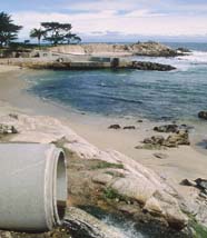
Flooding
FloodFlood
A flood is an overflow of an expanse of water that submerges land. The EU Floods directive defines a flood as a temporary covering by water of land not normally covered by water...
ing occurs when a watercourse is unable to convey the quantity of runoff flowing downstream. The frequency with which this occurs is described by a return period
Return period
A return period also known as a recurrence interval is an estimate of the interval of time between events like an earthquake, flood or river discharge flow of a certain intensity or size. It is a statistical measurement denoting the average recurrence interval over an extended period of time, and...
. Flooding is a natural process, which maintains ecosystem composition and processes, but it can also be altered by land use
Land use
Land use is the human use of land. Land use involves the management and modification of natural environment or wilderness into built environment such as fields, pastures, and settlements. It has also been defined as "the arrangements, activities and inputs people undertake in a certain land cover...
changes such as river engineering. Floods can be both beneficial to societies or cause damage. Agriculture along the Nile
Nile
The Nile is a major north-flowing river in North Africa, generally regarded as the longest river in the world. It is long. It runs through the ten countries of Sudan, South Sudan, Burundi, Rwanda, Democratic Republic of the Congo, Tanzania, Kenya, Ethiopia, Uganda and Egypt.The Nile has two major...
floodplain took advantage of the seasonal flooding that deposited nutrients beneficial for crops. However, as the number and susceptibility of settlements increase, flooding increasingly becomes a natural hazard. Adverse impacts span loss of life, property damage, contamination of water supplies, loss of crops, and social dislocation and temporary homelessness. Floods are among the most devastating of natural disasters.
Agricultural issues
A common context of run-off deals with agricultureAgriculture
Agriculture is the cultivation of animals, plants, fungi and other life forms for food, fiber, and other products used to sustain life. Agriculture was the key implement in the rise of sedentary human civilization, whereby farming of domesticated species created food surpluses that nurtured the...
. When farmland is tilled and bare soil is revealed, rainwater carries billions of tons of topsoil
Topsoil
Topsoil is the upper, outermost layer of soil, usually the top to . It has the highest concentration of organic matter and microorganisms and is where most of the Earth's biological soil activity occurs.-Importance:...
into waterways each year, causing loss of valuable topsoil and adding sediment to produce turbidity
Turbidity
Turbidity is the cloudiness or haziness of a fluid caused by individual particles that are generally invisible to the naked eye, similar to smoke in air. The measurement of turbidity is a key test of water quality....
in surface water
Surface water
Surface water is water collecting on the ground or in a stream, river, lake, wetland, or ocean; it is related to water collecting as groundwater or atmospheric water....
s.
The other context of agricultural issues involves the transport of agricultural chemicals (nitrates, phosphates, pesticides, herbicides etc.) via surface runoff. This result occurs when chemical use is excessive or poorly timed with respect to high precipitation. The resulting contaminated runoff represents not only a waste of agricultural chemicals, but also an environmental threat to downstream ecosystems. The alternative to conventional farming is organic farming
Organic farming
Organic farming is the form of agriculture that relies on techniques such as crop rotation, green manure, compost and biological pest control to maintain soil productivity and control pests on a farm...
which eliminates chemical usage.
Measurement and mathematical modeling
Runoff is analyzed by using mathematical modelMathematical model
A mathematical model is a description of a system using mathematical concepts and language. The process of developing a mathematical model is termed mathematical modeling. Mathematical models are used not only in the natural sciences and engineering disciplines A mathematical model is a...
s in combination with various water quality
Water quality
Water quality is the physical, chemical and biological characteristics of water. It is a measure of the condition of water relative to the requirements of one or more biotic species and or to any human need or purpose. It is most frequently used by reference to a set of standards against which...
sampling methods. Measurements can be made using continuous automated water quality analysis instruments targeted on pollutants such as specific organic
Organic compound
An organic compound is any member of a large class of gaseous, liquid, or solid chemical compounds whose molecules contain carbon. For historical reasons discussed below, a few types of carbon-containing compounds such as carbides, carbonates, simple oxides of carbon, and cyanides, as well as the...
or inorganic chemicals, pH
PH
In chemistry, pH is a measure of the acidity or basicity of an aqueous solution. Pure water is said to be neutral, with a pH close to 7.0 at . Solutions with a pH less than 7 are said to be acidic and solutions with a pH greater than 7 are basic or alkaline...
, turbidity etc. or targeted on secondary indicators such as dissolved oxygen. Measurements can also be made in batch form by extracting a single water sample and conducting any number of chemical or physical tests on that sample.
In the 1950s or earlier hydrology transport models appeared to calculate quantities of runoff, primarily for flood forecasting. Beginning in the early 1970s computer models were developed to analyze the transport of runoff carrying water pollutants, which considered dissolution
Solvation
Solvation, also sometimes called dissolution, is the process of attraction and association of molecules of a solvent with molecules or ions of a solute...
rates of various chemicals, infiltration
Infiltration (hydrology)
Infiltration is the process by which water on the ground surface enters the soil. Infiltration rate in soil science is a measure of the rate at which soil is able to absorb rainfall or irrigation. It is measured in inches per hour or millimeters per hour. The rate decreases as the soil becomes...
into soils and ultimate pollutant load delivered to receiving waters
Surface water
Surface water is water collecting on the ground or in a stream, river, lake, wetland, or ocean; it is related to water collecting as groundwater or atmospheric water....
.
One of the earliest models addressing chemical dissolution in runoff and resulting transport was developed in the early 1970s under contract to the United States Environmental Protection Agency
United States Environmental Protection Agency
The U.S. Environmental Protection Agency is an agency of the federal government of the United States charged with protecting human health and the environment, by writing and enforcing regulations based on laws passed by Congress...
(EPA). This computer model formed the basis of much of the mitigation study that led to strategies for land use
Land use
Land use is the human use of land. Land use involves the management and modification of natural environment or wilderness into built environment such as fields, pastures, and settlements. It has also been defined as "the arrangements, activities and inputs people undertake in a certain land cover...
and chemical handling controls.
Other computer models have been developed (such as the DSSAM Model
DSSAM Model
The DSSAM Model is a computer simulation developed for the Truckee River to analyze water quality impacts from land use and wastewater management decisions in the Truckee River Basin. This area includes the cities of Reno and Sparks, Nevada as well as the Lake Tahoe Basin...
) that allow surface runoff to be tracked through a river course as reactive water pollutants. In this case the surface runoff may be considered to be a line source
Line source
A line source is a source of air, noise, water contamination or electromagnetic radiation that emanates from a linear geometry...
of water pollution
Water pollution
Water pollution is the contamination of water bodies . Water pollution occurs when pollutants are discharged directly or indirectly into water bodies without adequate treatment to remove harmful compounds....
to the receiving waters.
Mitigation and treatment
- Land useLand useLand use is the human use of land. Land use involves the management and modification of natural environment or wilderness into built environment such as fields, pastures, and settlements. It has also been defined as "the arrangements, activities and inputs people undertake in a certain land cover...
development controls aimed at minimizing impervious surfaceImpervious surfaceImpervious surfaces are mainly artificial structures--such as pavements that are covered by impenetrable materials such as asphalt, concrete, brick, and stone--and rooftops...
s in urban areas - ErosionErosionErosion is when materials are removed from the surface and changed into something else. It only works by hydraulic actions and transport of solids in the natural environment, and leads to the deposition of these materials elsewhere...
controls for farmFarmA farm is an area of land, or, for aquaculture, lake, river or sea, including various structures, devoted primarily to the practice of producing and managing food , fibres and, increasingly, fuel. It is the basic production facility in food production. Farms may be owned and operated by a single...
s and constructionConstructionIn the fields of architecture and civil engineering, construction is a process that consists of the building or assembling of infrastructure. Far from being a single activity, large scale construction is a feat of human multitasking...
sites - Flood control programs
- Chemical use and handling controls in agricultureAgricultureAgriculture is the cultivation of animals, plants, fungi and other life forms for food, fiber, and other products used to sustain life. Agriculture was the key implement in the rise of sedentary human civilization, whereby farming of domesticated species created food surpluses that nurtured the...
, landscape maintenanceLandscape maintenanceLandscape maintenance is the art and vocation of keeping a landscape healthy, clean, safe and attractive, typically in a garden, yard, park, Institutional setting or estate...
, industrial use, etc.
Land use controls. Many world regulatory agencies have encouraged research on methods of minimizing total surface runoff by avoiding unnecessary hardscape
Hardscape
Hardscape, in the practice of landscaping, refers to the paved areas like streets & sidewalks, large business complexes & housing developments, and other industrial areas where the upper soil profile is no longer exposed to the actual surface of the Earth...
. Many municipalities have produced guidelines and codes (zoning
Zoning
Zoning is a device of land use planning used by local governments in most developed countries. The word is derived from the practice of designating permitted uses of land based on mapped zones which separate one set of land uses from another...
and related ordinances
Local ordinance
A local ordinance is a law usually found in a municipal code.-United States:In the United States, these laws are enforced locally in addition to state law and federal law.-Japan:...
) for land developers that encourage minimum width sidewalks, use of pavers set in earth for driveway
Driveway
A driveway is a type of private road for local access to one or a small group of structures, and is owned and maintained by an individual or group....
s and walkway
Walkway
In US English, a walkway is a composite or umbrella term for all engineered surfaces or structures which support the use of trails. These include sidewalks, footbridges, stiles, stairs, ramps, paseos or tunnels...
s and other design techniques to allow maximum water infiltration
Infiltration (hydrology)
Infiltration is the process by which water on the ground surface enters the soil. Infiltration rate in soil science is a measure of the rate at which soil is able to absorb rainfall or irrigation. It is measured in inches per hour or millimeters per hour. The rate decreases as the soil becomes...
in urban settings. An example land use control program can be viewed at seen in the city of Santa Monica, California
Santa Monica, California
Santa Monica is a beachfront city in western Los Angeles County, California, US. Situated on Santa Monica Bay, it is surrounded on three sides by the city of Los Angeles — Pacific Palisades on the northwest, Brentwood on the north, West Los Angeles on the northeast, Mar Vista on the east, and...
.
Erosion controls have appeared since medieval times when farmers realized the importance of contour farming to protect soil resources. Beginning in the 1950s these agricultural methods became increasingly more sophisticated. In the 1960s some state
U.S. state
A U.S. state is any one of the 50 federated states of the United States of America that share sovereignty with the federal government. Because of this shared sovereignty, an American is a citizen both of the federal entity and of his or her state of domicile. Four states use the official title of...
and local government
Local government
Local government refers collectively to administrative authorities over areas that are smaller than a state.The term is used to contrast with offices at nation-state level, which are referred to as the central government, national government, or federal government...
s began to focus their efforts on mitigation of construction runoff by requiring builders to implement erosion
Erosion control
Erosion control is the practice of preventing or controlling wind or water erosion in agriculture, land development and construction. Effective erosion controls are important techniques in preventing water pollution and soil loss.-Introduction:...
and sediment control
Sediment control
A sediment control is a practice or device designed to keep eroded soil on a construction site, so that it does not wash off and cause water pollution to a nearby stream, river, lake, or bay...
s (ESCs). This included such techniques as: use of straw bales and barriers to slow runoff on slopes, installation of silt fence
Silt fence
A silt fence, sometimes called a "filter fence," is a temporary sediment control device used on construction sites to protect water quality in nearby streams, rivers, lakes and bays from sediment in stormwater runoff...
s, programming construction for months that have less rainfall and minimizing extent and duration of exposed graded areas. Montgomery County
Montgomery County, Maryland
Montgomery County is a county in the U.S. state of Maryland, situated just to the north of Washington, D.C., and southwest of the city of Baltimore. It is one of the most affluent counties in the United States, and has the highest percentage of residents over 25 years of age who hold post-graduate...
, Maryland
Maryland
Maryland is a U.S. state located in the Mid Atlantic region of the United States, bordering Virginia, West Virginia, and the District of Columbia to its south and west; Pennsylvania to its north; and Delaware to its east...
implemented the first local government sediment control program in 1965, and this was followed by a statewide program in Maryland in 1970.
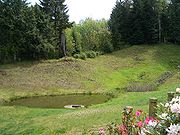
Flood control programs as early as the first half of the twentieth century became quantitative in predicting peak flows of riverine systems. Progressively strategies have been developed to minimize peak flows and also to reduce channel velocities. Some of the techniques commonly applied are: provision of holding ponds (also called detention basin
Detention basin
A detention basin is a stormwater management facility installed on, or adjacent to, tributaries of rivers, streams, lakes or bays that is designed to protect against flooding and, in some cases, downstream erosion by storing water for a limited period of a time. These basins are also called "dry...
s) to buffer riverine peak flows, use of energy dissipators in channels to reduce stream velocity and land use controls to minimize runoff.
Chemical use and handling. Following enactment of the U.S. Resource Conservation and Recovery Act
Resource Conservation and Recovery Act
The Resource Conservation and Recovery Act , enacted in 1976, is the principal Federal law in the United States governing the disposal of solid waste and hazardous waste.-History and Goals:...
(RCRA) in 1976, and later the Water Quality Act of 1987
Clean Water Act
The Clean Water Act is the primary federal law in the United States governing water pollution. Commonly abbreviated as the CWA, the act established the goals of eliminating releases of high amounts of toxic substances into water, eliminating additional water pollution by 1985, and ensuring that...
, states and cities have become more vigilant in controlling the containment and storage of toxic chemicals, thus preventing releases and leakage. Methods commonly applied are: requirements for double containment of underground storage tank
Underground storage tank
An Underground Storage Tank , in United States environmental law, is a tank and any underground piping connected to the tank that has at least 10 percent of its combined volume underground.-Tank types:...
s, registration of hazardous materials usage, reduction in numbers of allowed pesticides and more stringent regulation of fertilizers and herbicides in landscape maintenance. In many industrial cases, pretreatment of wastes is required, to minimize escape of pollutants into sanitary
Sanitary sewer
A sanitary sewer is a separate underground carriage system specifically for transporting sewage from houses and commercial buildings to treatment or disposal. Sanitary sewers serving industrial areas also carry industrial wastewater...
or stormwater sewers.
The U.S. Clean Water Act
Clean Water Act
The Clean Water Act is the primary federal law in the United States governing water pollution. Commonly abbreviated as the CWA, the act established the goals of eliminating releases of high amounts of toxic substances into water, eliminating additional water pollution by 1985, and ensuring that...
(CWA) requires that local governments in urbanized areas (as defined by the Census Bureau) obtain stormwater
Stormwater
Stormwater is water that originates during precipitation events. It may also be used to apply to water that originates with snowmelt that enters the stormwater system...
discharge permits for their drainage systems. Essentially this means that the locality must operate a stormwater management program for all surface runoff that enters the municipal separate storm sewer system ("MS4"). EPA and state regulations and related publications outline six basic components that each local program must contain:
- Public education (informing individuals, households, businesses about ways to avoid stormwater pollution)
- Public involvement (support public participation in implementation of local programs)
- Illicit discharge detection & elimination (removing sanitary sewerSanitary sewerA sanitary sewer is a separate underground carriage system specifically for transporting sewage from houses and commercial buildings to treatment or disposal. Sanitary sewers serving industrial areas also carry industrial wastewater...
or other non-stormwater connections to the MS4) - ConstructionConstructionIn the fields of architecture and civil engineering, construction is a process that consists of the building or assembling of infrastructure. Far from being a single activity, large scale construction is a feat of human multitasking...
site runoff controls (i.e. erosion & sediment controls) - Post-construction (i.e. permanent) stormwater management controls
- Pollution preventionPollution preventionPollution prevention ' describes activities that reduce the amount of pollution generated by a process, whether it is consumer consumption, driving, or industrial production...
and "good housekeeping" measures (e.g. system maintenance).
Other property owners which operate storm drain systems similar to municipalities, such as state highway systems, universities, military bases and prisons, are also subject to the MS4 permit requirements.
See also
- Agricultural wastewater
- Agricultural nutrient runoff
- CatchwaterCatchwaterA catchwater is a large-scale man-made device for catching surface runoff from hills and channelling it to reservoirs for later usage as a part of the public water supply....
- Flood forecastingFlood forecastingFlood forecasting is the use of real-time precipitation and streamflow data in rainfall-runoff and streamflow routing models to forecast flow rates and water levels for periods ranging from a few hours to days ahead, depending on the size of the watershed or river basin. Flood forecasting can also...
- Hydrological modellingHydrological modellingHydrologic models are simplified, conceptual representations of a part of the hydrologic cycle. They are primarily used for hydrologic prediction and for understanding hydrologic processes. Two major types of hydrologic models can be distinguished:...
- Nationwide Urban Runoff Program (NURP) – U.S. Research program
- Nonpoint source pollutionNonpoint source pollutionNonpoint source pollution refers to both water and air pollution from diffuse sources. Nonpoint source water pollution affects a water body from sources such as polluted runoff from agricultural areas draining into a river, or wind-borne debris blowing out to sea. Nonpoint source air pollution...
- Runoff curve number
- Runoff model (reservoir)Runoff model (reservoir)A runoff model is a mathematical model describing the rainfall - runoff relations of a rainfall catchment area, drainage basin or watershed. More precisely, it produces the surface runoff hydrograph as a response to a rainfall hydrograph as input...
- Soil conservationSoil conservationSoil conservation is a set of management strategies for prevention of soil being eroded from the Earth’s surface or becoming chemically altered by overuse, acidification, salinization or other chemical soil contamination...
- Soil contaminationSoil contaminationSoil contamination or soil pollution is caused by the presence of xenobiotic chemicals or other alteration in the natural soil environment....
- StormwaterStormwaterStormwater is water that originates during precipitation events. It may also be used to apply to water that originates with snowmelt that enters the stormwater system...
- Trophic state indexTrophic state indexThe quantities of nitrogen, phosphorus, and other biologically useful nutrients are theprimary determinants of a body of water's trophic state index...
- Water pollutionWater pollutionWater pollution is the contamination of water bodies . Water pollution occurs when pollutants are discharged directly or indirectly into water bodies without adequate treatment to remove harmful compounds....
External links
- USDA NRCS National Engineering Handbook, Stage Discharge Relationships, Ch. 14
- http://www.waterlog.info/software.htm provides free download of a conceptual model (RainOff) on rainfall-runoff relations based on a nonlinear reservoir.
- NutrientNet, an online nutrient trading tool developed by the World Resources Institute, designed to address water quality issues related to surface runoff and other pollution. See also the PA NutrientNet website designed for Pennsylvania's nutrient trading program.
- Bioretention as a low impact developmentLow impact developmentLow-impact development is a term used in the United States to describe a land planning and engineering design approach to managing stormwater runoff. LID emphasizes conservation and use of on-site natural features to protect water quality...
method of treating surface runoff - EPA Stormwater Permit Program
- EPA - Menu of Stormwater Best Management Practices
Further reading
- Gebert, W. A., D.J. Graczyk, and W.R. Krug. (1987). Average annual runoff in the United States, 1951-80 [Hydrologic Investigations Atlas HA-710]. Reston, Va.: U.S. Department of the Interior, U.S. Geological Survey.