

Severn Estuary
Encyclopedia
Estuary
An estuary is a partly enclosed coastal body of water with one or more rivers or streams flowing into it, and with a free connection to the open sea....
of the River Severn
River Severn
The River Severn is the longest river in Great Britain, at about , but the second longest on the British Isles, behind the River Shannon. It rises at an altitude of on Plynlimon, Ceredigion near Llanidloes, Powys, in the Cambrian Mountains of mid Wales...
, the longest river
River
A river is a natural watercourse, usually freshwater, flowing towards an ocean, a lake, a sea, or another river. In a few cases, a river simply flows into the ground or dries up completely before reaching another body of water. Small rivers may also be called by several other names, including...
in Great Britain
Great Britain
Great Britain or Britain is an island situated to the northwest of Continental Europe. It is the ninth largest island in the world, and the largest European island, as well as the largest of the British Isles...
. Its high tidal range
Tidal range
The tidal range is the vertical difference between the high tide and the succeeding low tide. Tides are the rise and fall of sea levels caused by the combined effects of the gravitational forces exerted by the Moon and the Sun and the rotation of the Earth...
means it has been at the centre of discussions in the UK regarding renewable energy.
Geography
Definitions of the limits of the Severn Estuary vary. A narrower definition adopted by some maps is that the river becomes the Severn Estuary after the Second Severn CrossingSecond Severn Crossing
The Second Severn Crossing is a bridge which carries the M4 motorway over the River Severn between England and Wales, inaugurated on 5 June 1996 by HRH The Prince of Wales to augment the traffic capacity of the original Severn Bridge built in 1966...
near Severn Beach
Severn Beach
Severn Beach is a village on the mouth of the river Severn in South Gloucestershire, England. A riverside footpath, which is part of the Severn Way, leads beneath the Second Severn Crossing bridge...
, South Gloucestershire
South Gloucestershire
South Gloucestershire is a unitary district in the ceremonial county of Gloucestershire, in South West England.-History:The district was created in 1996, when the county of Avon was abolished, by the merger of former area of the districts of Kingswood and Northavon...
and stretches to a line from Lavernock Point (south of Cardiff
Cardiff
Cardiff is the capital, largest city and most populous county of Wales and the 10th largest city in the United Kingdom. The city is Wales' chief commercial centre, the base for most national cultural and sporting institutions, the Welsh national media, and the seat of the National Assembly for...
) to Sand Point
Sand Point, Somerset
Sand Point in Somerset is the peninsula stretching out from Middle Hope, which lies to the north of the village of Kewstoke, and the stretch of coastline called Sand Bay. It is owned by the National Trust and is a popular place for walking...
near Weston-super-Mare
Weston-super-Mare
Weston-super-Mare is a seaside resort, town and civil parish in the unitary authority of North Somerset, which is within the ceremonial county of Somerset, England. It is located on the Bristol Channel coast, south west of Bristol, spanning the coast between the bounding high ground of Worlebury...
. A wider definition is that the estuary extends upstream to Aust
Aust
Aust is a small village in South Gloucestershire, England, the historical site of the eastern terminal of the Aust Ferry crossing route over the River Severn between England and Wales, believed to have been used in Roman times as a continuation of Icknield Street which led from Eastern England...
, the site of the Severn Bridge
Severn Bridge
The Severn Bridge is a suspension bridge spanning the River Severn between South Gloucestershire, just north of Bristol, England, and Monmouthshire in South Wales, via Beachley, a peninsula between the River Severn and River Wye estuary. It is the original Severn road crossing between England and...
. The estuary is about 2 miles (3.2 km) wide at Aust, and about 9 miles (14 km) wide between Cardiff and Weston-super-Mare.
The estuary forms the boundary between Wales
Wales
Wales is a country that is part of the United Kingdom and the island of Great Britain, bordered by England to its east and the Atlantic Ocean and Irish Sea to its west. It has a population of three million, and a total area of 20,779 km²...
and England
England
England is a country that is part of the United Kingdom. It shares land borders with Scotland to the north and Wales to the west; the Irish Sea is to the north west, the Celtic Sea to the south west, with the North Sea to the east and the English Channel to the south separating it from continental...
in this stretch. On the northern side of the estuary are the Caldicot and Wentloog Levels
Caldicot and Wentloog Levels
The Caldicot and Wentloog Levels are two areas of low-lying estuarine alluvial wetland and intertidal mudflats adjoining the north bank of the Severn estuary, either side of the River Usk estuary near Newport in south east Wales...
, on either side of the city of Newport
Newport
Newport is a city and unitary authority area in Wales. Standing on the banks of the River Usk, it is located about east of Cardiff and is the largest urban area within the historic county boundaries of Monmouthshire and the preserved county of Gwent...
; and, to the west, the city of Cardiff together with the resort of Penarth
Penarth
Penarth is a town and seaside resort in the Vale of Glamorgan , Wales, 5.2 miles south west from the city centre of the Welsh capital city of Cardiff and lying on the north shore of the Severn Estuary at the southern end of Cardiff Bay...
. On the southern, English, side, are Avonmouth
Avonmouth
Avonmouth is a port and suburb of Bristol, England, located on the Severn Estuary, at the mouth of the River Avon.The council ward of Avonmouth also includes Shirehampton and the western end of Lawrence Weston.- Geography :...
, Portishead
Portishead, Somerset
Portishead is a coastal town on the Severn Estuary within the unitary authority of North Somerset, which falls within the ceremonial county of Somerset England. It has a population of 22,000, an increase of over 3,000 since the 2001 census, with a growth rate of 40 per cent, considerably in excess...
, Clevedon
Clevedon
Clevedon is a town and civil parish in the unitary authority of North Somerset, which covers part of the ceremonial county of Somerset, England...
, and Weston-super-Mare. Denny Island
Denny Island
Denny Island is a small rocky island of , with scrub vegetation, in the Severn Estuary. Its rocky southern foreshore marks the boundary between England and Wales. Above high water mark, the island is reckoned administratively to Monmouthshire, South Wales...
is a small rocky island of 0.24 hectare (0.593052391236663 acre), with scrub vegetation, approximately three miles north of Portishead. Its rocky southern foreshore marks the boundary between England
England
England is a country that is part of the United Kingdom. It shares land borders with Scotland to the north and Wales to the west; the Irish Sea is to the north west, the Celtic Sea to the south west, with the North Sea to the east and the English Channel to the south separating it from continental...
and Wales
Wales
Wales is a country that is part of the United Kingdom and the island of Great Britain, bordered by England to its east and the Atlantic Ocean and Irish Sea to its west. It has a population of three million, and a total area of 20,779 km²...
, but the island itself is reckoned administratively to Monmouthshire
Monmouthshire
Monmouthshire is a county in south east Wales. The name derives from the historic county of Monmouthshire which covered a much larger area. The largest town is Abergavenny. There are many castles in Monmouthshire .-Historic county:...
, Wales.

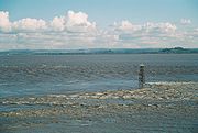
The estuary's funnel shape, its tidal range, and the underlying geology of rock, gravel and sand, produce strong tidal streams and high turbidity
Turbidity
Turbidity is the cloudiness or haziness of a fluid caused by individual particles that are generally invisible to the naked eye, similar to smoke in air. The measurement of turbidity is a key test of water quality....
, giving the water a notably brown coloration.
West of the line between Lavernock Point and Sand Point is the Bristol Channel
Bristol Channel
The Bristol Channel is a major inlet in the island of Great Britain, separating South Wales from Devon and Somerset in South West England. It extends from the lower estuary of the River Severn to the North Atlantic Ocean...
, which in turn discharges into the Celtic Sea
Celtic Sea
The Celtic Sea is the area of the Atlantic Ocean off the south coast of Ireland bounded to the east by Saint George's Channel; other limits include the Bristol Channel, the English Channel, and the Bay of Biscay, as well as adjacent portions of Wales, Cornwall, Devon, and Brittany...
and the wider Atlantic Ocean
Atlantic Ocean
The Atlantic Ocean is the second-largest of the world's oceanic divisions. With a total area of about , it covers approximately 20% of the Earth's surface and about 26% of its water surface area...
. The islands of Steep Holm
Steep Holm
Steep Holm is an English island lying in the Bristol Channel. The island covers at high tide, expanding to at mean low water. At its highest point it is above mean sea level. It lies within the historic boundaries of Somerset and administratively, it forms part of North Somerset...
and Flat Holm
Flat Holm
Flat Holm is a limestone island lying in the Bristol Channel approximately from Lavernock Point in the Vale of Glamorgan, but in the City and County of Cardiff. It includes the most southerly point of Wales....
are located close to that line, in the middle of the estuary.
Sometimes the term Severn Estuary is used to include the tidal upstream stretch between Gloucester and Aust. During the highest tides on the upper reaches of this stretch, the rising water is funnelled up the estuary into the Severn bore
Severn bore
The Severn bore is a tidal bore seen on the tidal reaches of the River Severn in England. It forms somewhat upstream of Sharpness, and can be seen as far upstream as Maisemore.- Formation :...
, a self-reinforcing solitary wave that travels rapidly upstream against the river current..
Conservation
The tidal range results in the estuary having one of the most extensive intertidal wildlife habitats in the UK, comprising mudflats, sandflats, rocky platforms and islands. These form a basis for plant and animal communities typical of extreme physical conditions of liquid mud and tide-swept sand and rock. The estuary is recognised as a wetland area of international importance and is designated as a Ramsar site.Parts of the estuary have also been designated a Site of Special Scientific Interest
Site of Special Scientific Interest
A Site of Special Scientific Interest is a conservation designation denoting a protected area in the United Kingdom. SSSIs are the basic building block of site-based nature conservation legislation and most other legal nature/geological conservation designations in Great Britain are based upon...
. The SSSI includes most of the foreshore upstream from Cardiff and Brean Down
Brean Down
Brean Down is a promontory off the coast of Somerset standing high and extending into the Bristol Channel at the eastern end of Bridgwater Bay between Weston-super-Mare and Burnham-on-Sea....
and most of the upper estuary as far as Sharpness
Sharpness
Sharpness is an English port in Gloucestershire, one of the most inland in Britain, and eighth largest in the South West. It is on the River Severn at , at a point where the tidal range, though less than at Avonmouth downstream , is still large .The village of Sharpness is pronounced with the...
. The Upper Severn Estuary SSSI covers the tidal river between Purton
Purton, Berkeley
Purton is a village on the east bank of the River Severn, 3 miles north of Berkeley, in Gloucestershire, England. The village is in the civil parish of Hinton. It lies opposite the hamlet of Purton on the west bank of the river....
and Frampton on Severn.
Tidal power
Bristol Channel
The Bristol Channel is a major inlet in the island of Great Britain, separating South Wales from Devon and Somerset in South West England. It extends from the lower estuary of the River Severn to the North Atlantic Ocean...
a focus for tidal energy
Tidal power
Tidal power, also called tidal energy, is a form of hydropower that converts the energy of tides into useful forms of power - mainly electricity....
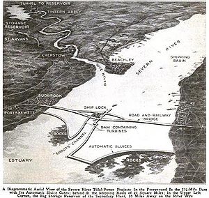
schemes and ideas. Plans for a Severn Barrage
Severn Barrage
The Severn Barrage refers to a range of ideas for building a barrage from the English coast to the Welsh coast over the Severn tidal estuary. Ideas for damming or barraging the Severn estuary have existed since the 19th century. The building of such a barrage would be a huge engineering feat,...
— running 16 km (9.9 mi) across the Bristol Channel from Lavernock Point near to and south west of Cardiff
Cardiff
Cardiff is the capital, largest city and most populous county of Wales and the 10th largest city in the United Kingdom. The city is Wales' chief commercial centre, the base for most national cultural and sporting institutions, the Welsh national media, and the seat of the National Assembly for...
to Brean Down
Brean Down
Brean Down is a promontory off the coast of Somerset standing high and extending into the Bristol Channel at the eastern end of Bridgwater Bay between Weston-super-Mare and Burnham-on-Sea....
near and just south west of Weston-super-Mare
Weston-super-Mare
Weston-super-Mare is a seaside resort, town and civil parish in the unitary authority of North Somerset, which is within the ceremonial county of Somerset, England. It is located on the Bristol Channel coast, south west of Bristol, spanning the coast between the bounding high ground of Worlebury...
in Somerset
Somerset
The ceremonial and non-metropolitan county of Somerset in South West England borders Bristol and Gloucestershire to the north, Wiltshire to the east, Dorset to the south-east, and Devon to the south-west. It is partly bounded to the north and west by the Bristol Channel and the estuary of the...
— would generate a massive 8640 MW when the tide flows, and have been discussed for several decades now. The power generated would come from a lake of 185 square miles (479 km²) with a potential energy depth of 14 metres (46 ft). Tidal power only runs for around ten hours a day, but by using the enclosed lake as a reservoir of potential energy more hours of operation could be achieved. Other energy sources, such as wind and solar power, also create electricity at times that do not always match when it is needed. Excess power could be stored by pumping water uphill
Pumped-storage hydroelectricity
Pumped-storage hydroelectricity is a type of hydroelectric power generation used by some power plants for load balancing. The method stores energy in the form of water, pumped from a lower elevation reservoir to a higher elevation. Low-cost off-peak electric power is used to run the pumps...
, as is already done at a variety of other installations in the UK.
The UK Government shelved the plans in the late 1980s due largely to cost issues and local environmental concerns. However, this was before recent huge rises in the price of energy, and before global warming
Global warming
Global warming refers to the rising average temperature of Earth's atmosphere and oceans and its projected continuation. In the last 100 years, Earth's average surface temperature increased by about with about two thirds of the increase occurring over just the last three decades...
had started to be taken seriously. In April 2006 the Welsh Assembly approved the idea of utilising the tidal power, but the RSPB
Royal Society for the Protection of Birds
Bird Notes and News was first published in April 1903.The title changed to 'Bird Notes' in 1947. In the 1950s, there were four copies per year . Each volume covered two years, spread over three calendar years...
has raised serious concerns about the effect on the mud flats, that have European Environmental protection status, and the UK government Energy Review published later in the year did not endorse the scheme.
Opinion is still divided on the benefits of a proposed barrage. John Hutton
John Hutton (Labour MP)
John Matthew Patrick Hutton, Baron Hutton of Furness is a British Labour Party politician who was the Member of Parliament for Barrow and Furness in Cumbria from 1992 to 2010, and has served in a number of Cabinet offices, including Defence Secretary and Business Secretary...
, Secretary of State for Business, Enterprise and Regulatory Reform, announced a further feasibility study on 25 September 2007. The Severn Tidal Power Feasibility Study
Severn Tidal Power Feasibility Study
Severn Tidal Power Feasibility Study is the name of a UK Government feasibility study into a tidal power project looking at the possibility of using the huge tidal range in the Severn Estuary and Bristol Channel to generate electricity....
was launched in January 2008 to assess all tidal range technologies (including barrages, lagoons and others). The study will look at the costs, benefits and impacts of a Severn tidal power scheme and will help Government decide whether it could or could not support such a scheme.
The Severn Estuary has the potential to generate more renewable electricity than all other UK estuaries. If harnessed, it could create up to 5% of the UK’s electricity, contributing significantly to UK climate change goals as well as European Union renewable energy targets. The proposal for a hydro-electric
Hydroelectricity
Hydroelectricity is the term referring to electricity generated by hydropower; the production of electrical power through the use of the gravitational force of falling or flowing water. It is the most widely used form of renewable energy...
barrier to generate 8.6 GW and meet five percent of Britain's power needs, is being opposed by environmental groups.
Severn Estuary Partnership
The Severn Estuary Partnership (SEP) was set up in 1995 as an independent initiative to focus the activities of local government, statutory authorities and interested parties such as farmers and fisherman. Its stated aim is To bring together all those involved in the development, management and use of the Estuary within a framework which encourages the integration of their interests and responsibilities to achieve common objectives.In 2001 SEP published the Strategy for the Severn Estuary, which sets out a plan for the management of the estuary.
SEP uses a geographically extended definition of the Severn Estuary, beginning at the tidal limit of the River Severn in Gloucester
Gloucester
Gloucester is a city, district and county town of Gloucestershire in the South West region of England. Gloucester lies close to the Welsh border, and on the River Severn, approximately north-east of Bristol, and south-southwest of Birmingham....
and ending at a line drawn between Hurlestone Point near Minehead
Minehead
Minehead is a coastal town and civil parish in Somerset, England. It lies on the south bank of the Bristol Channel, north-west of the county town of Taunton, from the border with the county of Devon and in proximity of the Exmoor National Park...
and Nash Point
Nash Point
Nash Point is a headland and beach in the Monknash Coast of the Vale of Glamorgan in south Wales. It is a popular location for ramblers and hiking along the cliffs to Llantwit Major beach....
in the Vale of Glamorgan
Vale of Glamorgan
The Vale of Glamorgan is a county borough in Wales; an exceptionally rich agricultural area, it lies in the southern part of Glamorgan, South Wales...
.