
River Severn
Overview
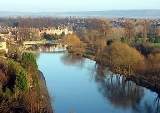
The River Severn is the longest river
in Great Britain
, at about 354 kilometres (220 mi), but the second longest on the British Isles
, behind the River Shannon
. It rises at an altitude of 610 metres (2,001 ft) on Plynlimon
, Ceredigion
near Llanidloes
, Powys
, in the Cambrian Mountains
of mid Wales
. It then flows through Shropshire
, Worcestershire
and Gloucestershire
, with the county town
s of Shrewsbury
, Worcester
, and Gloucester
on its banks. With an average discharge of 107 m³/s at Apperley
, Gloucestershire, the Severn is the greatest river in terms of water flow in England and Wales.
The river is usually considered to become the Severn Estuary
after the Second Severn Crossing
between Severn Beach
, South Gloucestershire
and Sudbrook
, Monmouthshire
.
River
A river is a natural watercourse, usually freshwater, flowing towards an ocean, a lake, a sea, or another river. In a few cases, a river simply flows into the ground or dries up completely before reaching another body of water. Small rivers may also be called by several other names, including...
in Great Britain
Great Britain
Great Britain or Britain is an island situated to the northwest of Continental Europe. It is the ninth largest island in the world, and the largest European island, as well as the largest of the British Isles...
, at about 354 kilometres (220 mi), but the second longest on the British Isles
British Isles
The British Isles are a group of islands off the northwest coast of continental Europe that include the islands of Great Britain and Ireland and over six thousand smaller isles. There are two sovereign states located on the islands: the United Kingdom of Great Britain and Northern Ireland and...
, behind the River Shannon
River Shannon
The River Shannon is the longest river in Ireland at . It divides the west of Ireland from the east and south . County Clare, being west of the Shannon but part of the province of Munster, is the major exception...
. It rises at an altitude of 610 metres (2,001 ft) on Plynlimon
Plynlimon
Plynlimon is the highest point of the Cambrian Mountains in Wales, and the highest point in Mid Wales. It is a massif that dominates the countryside of northern Ceredigion....
, Ceredigion
Ceredigion
Ceredigion is a county and former kingdom in mid-west Wales. As Cardiganshire , it was created in 1282, and was reconstituted as a county under that name in 1996, reverting to Ceredigion a day later...
near Llanidloes
Llanidloes
Llanidloes is a town along the A470 road and B4518 road in Powys, within the historic county boundaries of Montgomeryshire , Mid Wales.It is the first town on the River Severn...
, Powys
Powys
Powys is a local-government county and preserved county in Wales.-Geography:Powys covers the historic counties of Montgomeryshire and Radnorshire, most of Brecknockshire , and a small part of Denbighshire — an area of 5,179 km², making it the largest county in Wales by land area.It is...
, in the Cambrian Mountains
Cambrian Mountains
The Cambrian Mountains are a series of mountain ranges in Wales, reaching from, and including, the South Wales mountains of the Brecon Beacons, north Carmarthenshire and Ceredigion, the Black Mountains of eastern Wales, to Snowdonia in North Wales...
of mid Wales
Mid Wales
Mid Wales is the name given to the central region of Wales. The Mid Wales Regional Committee of the National Assembly for Wales covered the counties of Ceredigion and Powys and the area of Gwynedd that had previously been the district of Meirionydd. A similar definition is used by the BBC...
. It then flows through Shropshire
Shropshire
Shropshire is a county in the West Midlands region of England. For Eurostat purposes, the county is a NUTS 3 region and is one of four counties or unitary districts that comprise the "Shropshire and Staffordshire" NUTS 2 region. It borders Wales to the west...
, Worcestershire
Worcestershire
Worcestershire is a non-metropolitan county, established in antiquity, located in the West Midlands region of England. For Eurostat purposes it is a NUTS 3 region and is one of three counties that comprise the "Herefordshire, Worcestershire and Warwickshire" NUTS 2 region...
and Gloucestershire
Gloucestershire
Gloucestershire is a county in South West England. The county comprises part of the Cotswold Hills, part of the flat fertile valley of the River Severn, and the entire Forest of Dean....
, with the county town
County town
A county town is a county's administrative centre in the United Kingdom or Ireland. County towns are usually the location of administrative or judicial functions, or established over time as the de facto main town of a county. The concept of a county town eventually became detached from its...
s of Shrewsbury
Shrewsbury
Shrewsbury is the county town of Shropshire, in the West Midlands region of England. Lying on the River Severn, it is a civil parish home to some 70,000 inhabitants, and is the primary settlement and headquarters of Shropshire Council...
, Worcester
Worcester
The City of Worcester, commonly known as Worcester, , is a city and county town of Worcestershire in the West Midlands of England. Worcester is situated some southwest of Birmingham and north of Gloucester, and has an approximate population of 94,000 people. The River Severn runs through the...
, and Gloucester
Gloucester
Gloucester is a city, district and county town of Gloucestershire in the South West region of England. Gloucester lies close to the Welsh border, and on the River Severn, approximately north-east of Bristol, and south-southwest of Birmingham....
on its banks. With an average discharge of 107 m³/s at Apperley
Apperley
Apperley is a small village in Gloucestershire, England. It is part of the parish of its smaller and more famous neighbour, Deerhurst.The village has a thriving cricket club that reached the final of the National Village Cricket Championship in 1998. The England cricketer Alfred Dipper was born in...
, Gloucestershire, the Severn is the greatest river in terms of water flow in England and Wales.
The river is usually considered to become the Severn Estuary
Severn Estuary
The Severn Estuary is the estuary of the River Severn, the longest river in Great Britain. Its high tidal range means it has been at the centre of discussions in the UK regarding renewable energy.-Geography:...
after the Second Severn Crossing
Second Severn Crossing
The Second Severn Crossing is a bridge which carries the M4 motorway over the River Severn between England and Wales, inaugurated on 5 June 1996 by HRH The Prince of Wales to augment the traffic capacity of the original Severn Bridge built in 1966...
between Severn Beach
Severn Beach
Severn Beach is a village on the mouth of the river Severn in South Gloucestershire, England. A riverside footpath, which is part of the Severn Way, leads beneath the Second Severn Crossing bridge...
, South Gloucestershire
South Gloucestershire
South Gloucestershire is a unitary district in the ceremonial county of Gloucestershire, in South West England.-History:The district was created in 1996, when the county of Avon was abolished, by the merger of former area of the districts of Kingswood and Northavon...
and Sudbrook
Sudbrook, Monmouthshire
Sudbrook is a village in Monmouthshire, south east Wales. It is located 4 miles south west of Chepstow and 1 mile east of Caldicot. It lies close to the Second Severn Crossing on the Severn Estuary, and adjoins the village of Portskewett. It was largely built in the late 19th century for workers...
, Monmouthshire
Monmouthshire
Monmouthshire is a county in south east Wales. The name derives from the historic county of Monmouthshire which covered a much larger area. The largest town is Abergavenny. There are many castles in Monmouthshire .-Historic county:...
.
Unanswered Questions
Discussions