
River Brue
Encyclopedia
The River Brue originates in the parish of Brewham
in Somerset
, England, and reaches the sea some 50 km west at Burnham-on-Sea
. It originally took a different route from Glastonbury
to the sea, but this was changed by the monastery in the twelfth century.
The Brue Valley Living Landscape
is a conservation
project based on the Somerset Levels and Moors and managed by the Somerset Wildlife Trust
. The project commenced in January 2009 and aims to restore, recreate and reconnect habitat
. It aims to ensure that wildlife is enhanced and capable of sustaining itself in the face of climate change
while guaranteeing farmers and other landowners can continue to use their land profitably. It is one of an increasing number of landscape scale conservation
projects in the UK.
and the sources of the River Wylye
and the Dorset Stour
. It falls quickly in a narrow valley to a point just beyond Bruton
where it is joined by the River Pitt. Here is takes a meandering route through a broad, flat-bottomed valley between Castle Cary
and Alhampton. By the time it reaches Baltonsborough
it is only some 10m above sea level and the surrounding countryside is drained into it by way of numerous rhyne
s. It passes Glastonbury
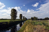
before flowing in a largely artificial channel across the Somerset Levels
and into the Bristol Channel
at Highbridge
. It is joined by the North Drain, White's River (which takes the water of the River Sheppey
, Cripps River (an artificial channel that connects it to the River Huntspill
) and many drainage rhynes. It is tidal below the sluices at New Clyce Bridge in Highbridge.
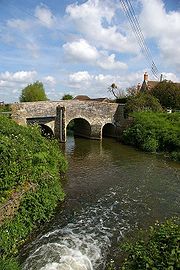
Bow Bridge
is a 15th century Packhorse bridge
over the River Brue in Plox, Bruton
. It has been designated as a Grade I listed building, and Scheduled Ancient Monument
. The bridge may have been built as a link between the former Bruton Abbey
, and its Court House in the High Street. The bridge was restored after floods on July 12, 1982.
The River Brue has a long history of flooding. Its lower reaches are close to sea-level, and the river above Bruton drains an area of 31 km2 into a steep and narrow valley. In 1768 the river rose very rapidly and destroyed a stone bridge in Bruton. In 1984 a protective dam was built 1 km upstream from the town.
The valley includes several Sites of Special Scientific Interest
including Westhay Moor
.
 At the time of King Arthur
the Brue formed a lake just south of the hilly ground on which Glastonbury stands. This lake is one of the locations suggested by Arthurian legend as the home of the Lady of the Lake
. Pomparles Bridge stood at the western end of this lake, guarding Glastonbury from the south, and it is suggested that it was here that Sir Bedivere
threw Excalibur
into the waters after King Arthur fell at the Battle of Camlann
.
John Leland noted in the 16th century that the bridge had four arches, while W.Phelps in an 1839 illustration as having only two arches, one pointed, probably C14-15, and the other round. Excavations in 1912 found the remains of a second round arch regarded as C12 work. The current concrete arch bridge was built in 1911 and extended in 1972. It carries the A39 road
over the Brue.
from the south, around the western side (through Beckery), and then north through the Panborough-Bleadney gap in the Wedmore
-Wookey
Hills, to join the River Axe just north of Bleadney. This route made it difficult for the officials of Glastonbury Abbey
to transport produce from their outlying estates to the Abbey, and when the valley of the river Axe was in flood it backed up to flood Glastonbury itself. Sometime between 1230 and 1250 a new channel was constructed westwards into Meare Pool
north of Meare
, and further westwards to Mark Moor. It then divided into two channels, one the Pilrow cut flowing north through Mark
to join the Axe near Edingworth, and the other directly west to the sea at Highbridge
.
and Wedmore
. In 1794 the annual floods filled the whole of the Brue valley. Work by the Commissioners of Sewers led to the 1801 Brue Drainage Act which enabled sections at Highbridge and Cripp's Bridge to be straightened, and new feeder channels such as the North and South Drains to be constructed. In 1803 the clyse
at Highbridge, which had been built before 1485, was replaced and moved further downstream.
The River Brue has a long history of flooding in Bruton
. In 1768 the river rose very rapidly and destroyed a stone bridge. On the 28 June 1917, 242.8 mm of rain fell in 24 hours at Bruton, leaving a water mark on one pub twenty feet above the normal level of the river. In 1984 a protective dam was built 1 km upstream from the town.
and Brown's Canal once connected to the river. The Glastonbury Canal
used the course of the River Brue from Highbridge to Cripp's Bridge, and part of the South Drain to Ashcott Corner.
and many pillboxes
were constructed along the river.
at Pitcombe
, near Bruton
, is a watermill
which is still used to mill cattle feed. A 12 kW hydroelectric turbine was recently installed at the site. There has been a mill here since the 13th century, but the current building was built in 1810.
During monastic times, there were several fish weirs
along the lower reaches of the river. They used either nets or baskets, the fishing rights belonging to the Bishop of Bath and Wells
and the Abbot of Glastonbury
.
will find pike
in excess of 20 lb, with good stocks of chub
, dace
, roach, bream
, tench
, perch
, rudd
, and gudgeon
. There are trout
in the upper reaches.
There are several access points along the river suitable for canoeing
, and the river has been paddled as far up as Bruton, but above West Lydford only after recent rain. There are public footpaths alongside many stretches of the river.
Brewham
Brewham is a civil parish in Somerset, England, consisting of the villages of North Brewham and South Brewham, on either side of the river in the Brue Valley east of Bruton and south-west of Frome in the South Somerset district. The parish has a population of 410.-History:The name of the...
in Somerset
Somerset
The ceremonial and non-metropolitan county of Somerset in South West England borders Bristol and Gloucestershire to the north, Wiltshire to the east, Dorset to the south-east, and Devon to the south-west. It is partly bounded to the north and west by the Bristol Channel and the estuary of the...
, England, and reaches the sea some 50 km west at Burnham-on-Sea
Burnham-on-Sea
Burnham-on-Sea is a town in Somerset, England, at the mouth of the River Parrett and Bridgwater Bay. Burnham was a small village until the late 18th century, when it began to grow because of its popularity as a seaside resort. It forms part of the parish of Burnham-on-Sea and Highbridge...
. It originally took a different route from Glastonbury
Glastonbury
Glastonbury is a small town in Somerset, England, situated at a dry point on the low lying Somerset Levels, south of Bristol. The town, which is in the Mendip district, had a population of 8,784 in the 2001 census...
to the sea, but this was changed by the monastery in the twelfth century.
The Brue Valley Living Landscape
Brue Valley Living Landscape
The Brue Valley Living Landscape is a UK conservation project based on the Somerset Levels and Moors and managed by the Somerset Wildlife Trust. The project commenced in January 2009 and aims to restore, recreate and reconnect habitat...
is a conservation
Conservation biology
Conservation biology is the scientific study of the nature and status of Earth's biodiversity with the aim of protecting species, their habitats, and ecosystems from excessive rates of extinction...
project based on the Somerset Levels and Moors and managed by the Somerset Wildlife Trust
Somerset Wildlife Trust
Somerset Wildlife Trust is a wildlife trust covering the county of Somerset, England.The trust, which was established in 1964, aims to safeguard the county's wildlife and wild places for this and future generations and manages almost 80 nature reserves. Examples include Fyne Court, Westhay Moor,...
. The project commenced in January 2009 and aims to restore, recreate and reconnect habitat
Habitat
* Habitat , a place where a species lives and grows*Human habitat, a place where humans live, work or play** Space habitat, a space station intended as a permanent settlement...
. It aims to ensure that wildlife is enhanced and capable of sustaining itself in the face of climate change
Climate change
Climate change is a significant and lasting change in the statistical distribution of weather patterns over periods ranging from decades to millions of years. It may be a change in average weather conditions or the distribution of events around that average...
while guaranteeing farmers and other landowners can continue to use their land profitably. It is one of an increasing number of landscape scale conservation
Landscape scale conservation
Landscape scale conservation is a concept that has arisen, primarily in the UK since the mid-1990s, in response to both the challenges of climate change and a perceived excessive focus on site based conservation...
projects in the UK.
Course
The River Brue originates in the same hills as King Alfred's TowerKing Alfred's Tower
King Alfred's Tower or The Folly of King Alfred the Great is in the parish of Brewham, Somerset, and was built as part of the celebrated Stourhead estate and landscape. The tower stands on Kingsettle Hill and nowadays belongs to the National Trust...
and the sources of the River Wylye
River Wylye
The River Wylye is a classic southern England chalk stream; champagne clear water flowing over gravel. Consequently, it is popular with anglers keen on fly fishing.- Course :...
and the Dorset Stour
River Stour, Dorset
The River Stour is a 60.5 mile long river which flows through Wiltshire and Dorset in southern England, and drains into the English Channel. It is sometimes called the Dorset Stour to distinguish it from rivers of the same name...
. It falls quickly in a narrow valley to a point just beyond Bruton
Bruton
Bruton is a town and civil parish in Somerset, England, situated on the River Brue seven miles south-east of Shepton Mallet, just south of Snakelake Hill and Coombe Hill, ten miles north-west of Gillingham and twelve miles south-west of Frome in the South Somerset district. The town has a...
where it is joined by the River Pitt. Here is takes a meandering route through a broad, flat-bottomed valley between Castle Cary
Castle Cary
Castle Cary is a market town and civil parish in south Somerset, England, north west of Wincanton and south of Shepton Mallet.The town is situated on the River Cary, a tributary of the Parrett.-History:...
and Alhampton. By the time it reaches Baltonsborough
Baltonsborough
Baltonsborough is a village and civil parish in the Mendip district of Somerset, England. According to the 2001 census it had a population of 873. Apart from Baltonsborough village, the parish also contains the hamlets of Ham Street, Catsham and Southwood....
it is only some 10m above sea level and the surrounding countryside is drained into it by way of numerous rhyne
Rhyne
A rhyne , rhine/rhyne , or reen is a drainage ditch, or canal, used to turn areas of wetland at around sea level into useful pasture....
s. It passes Glastonbury
Glastonbury
Glastonbury is a small town in Somerset, England, situated at a dry point on the low lying Somerset Levels, south of Bristol. The town, which is in the Mendip district, had a population of 8,784 in the 2001 census...
before flowing in a largely artificial channel across the Somerset Levels
Somerset Levels
The Somerset Levels, or the Somerset Levels and Moors as they are less commonly but more correctly known, is a sparsely populated coastal plain and wetland area of central Somerset, South West England, between the Quantock and Mendip Hills...
and into the Bristol Channel
Bristol Channel
The Bristol Channel is a major inlet in the island of Great Britain, separating South Wales from Devon and Somerset in South West England. It extends from the lower estuary of the River Severn to the North Atlantic Ocean...
at Highbridge
Highbridge, Somerset
Highbridge is a small market town situated on the edge of the Somerset Levels near the mouth of the River Brue. It is in the County of Somerset, and is approximately north west of Taunton, the county town of Somerset. Highbridge is in the District of Sedgemoor, being situated approximately north...
. It is joined by the North Drain, White's River (which takes the water of the River Sheppey
River Sheppey
The River Sheppey has its source in a group of springs west of the village of Doulting, near Shepton Mallet in Somerset, England. It flows through the wetlands to the north of the Polden Hills and ultimately joins the River Brue.- Route :...
, Cripps River (an artificial channel that connects it to the River Huntspill
River Huntspill
The River Huntspill is an artificial river, in the Somerset Levels, in the Sedgemoor district of Somerset, England. It was built in 1940 to supply process water to the armaments factory at Puriton, and has resulted in reduced flooding of the lower Brue Valley.-History:The concept for the Huntspill...
) and many drainage rhynes. It is tidal below the sluices at New Clyce Bridge in Highbridge.
Bow Bridge
Bow Bridge, Plox
Bow Bridge is a 15th century Packhorse bridge over the River Brue in Plox, Bruton, Somerset, England. It has been designated as a Grade I listed building, and Scheduled Ancient Monument....
is a 15th century Packhorse bridge
Packhorse bridge
A packhorse bridge is a bridge intended to carry packhorses across a river or stream. Typically a packhorse bridge consists of one or more narrow masonry arches, and has low parapets so as not to interfere with the horse's panniers.Packhorse bridges were often built on the trade routes that...
over the River Brue in Plox, Bruton
Bruton
Bruton is a town and civil parish in Somerset, England, situated on the River Brue seven miles south-east of Shepton Mallet, just south of Snakelake Hill and Coombe Hill, ten miles north-west of Gillingham and twelve miles south-west of Frome in the South Somerset district. The town has a...
. It has been designated as a Grade I listed building, and Scheduled Ancient Monument
Scheduled Ancient Monument
In the United Kingdom, a scheduled monument is a 'nationally important' archaeological site or historic building, given protection against unauthorized change. The various pieces of legislation used for legally protecting heritage assets from damage and destruction are grouped under the term...
. The bridge may have been built as a link between the former Bruton Abbey
Bruton Abbey
Bruton Abbey in Bruton, Somerset was originally founded as a Benedictine priory by Algar, Earl of Cornwall in about 1005. It was subsequently refounded as a house of Augustinian canons in 1135, by William de Mohun, who later became the Earl of Somerset. The village used the north aisle of the...
, and its Court House in the High Street. The bridge was restored after floods on July 12, 1982.
The River Brue has a long history of flooding. Its lower reaches are close to sea-level, and the river above Bruton drains an area of 31 km2 into a steep and narrow valley. In 1768 the river rose very rapidly and destroyed a stone bridge in Bruton. In 1984 a protective dam was built 1 km upstream from the town.
The valley includes several Sites of Special Scientific Interest
Site of Special Scientific Interest
A Site of Special Scientific Interest is a conservation designation denoting a protected area in the United Kingdom. SSSIs are the basic building block of site-based nature conservation legislation and most other legal nature/geological conservation designations in Great Britain are based upon...
including Westhay Moor
Westhay Moor
Westhay Moor is a 513.7 hectare biological Site of Special Scientific Interest 2.5km north-east of Westhay village and 4km from Wedmore in Somerset, notified in 1971...
.
Pomparles Bridge
King Arthur
King Arthur is a legendary British leader of the late 5th and early 6th centuries, who, according to Medieval histories and romances, led the defence of Britain against Saxon invaders in the early 6th century. The details of Arthur's story are mainly composed of folklore and literary invention, and...
the Brue formed a lake just south of the hilly ground on which Glastonbury stands. This lake is one of the locations suggested by Arthurian legend as the home of the Lady of the Lake
Lady of the Lake
The Lady of the Lake is the name of several related characters who play parts in the Arthurian legend. These characters' roles include giving King Arthur his sword Excalibur, enchanting Merlin, and raising Lancelot after the death of his father...
. Pomparles Bridge stood at the western end of this lake, guarding Glastonbury from the south, and it is suggested that it was here that Sir Bedivere
Bedivere
In Arthurian legend, Sir Bedivere is the Knight of the Round Table who returns Excalibur to the Lady of the Lake. He serves as King Arthur's marshal and is frequently associated with Sir Kay...
threw Excalibur
Excalibur
Excalibur is the legendary sword of King Arthur, sometimes attributed with magical powers or associated with the rightful sovereignty of Great Britain. Sometimes Excalibur and the Sword in the Stone are said to be the same weapon, but in most versions they are considered separate. The sword was...
into the waters after King Arthur fell at the Battle of Camlann
Battle of Camlann
The Battle of Camlann is best known as the final battle of King Arthur, where he either died in battle, or was fatally wounded fighting his enemy Mordred.-Historicity:...
.
John Leland noted in the 16th century that the bridge had four arches, while W.Phelps in an 1839 illustration as having only two arches, one pointed, probably C14-15, and the other round. Excavations in 1912 found the remains of a second round arch regarded as C12 work. The current concrete arch bridge was built in 1911 and extended in 1972. It carries the A39 road
A39 road
The A39 is an A road in south west England. It runs south-west from Bath in Somerset through Wells, Glastonbury, Street and Bridgwater. It then follows the north coast of Somerset and Devon through Williton, Minehead, Porlock, Lynmouth, Barnstaple, Bideford, Stratton, Camelford, Wadebridge and St...
over the Brue.
Alteration of route
Prior to the 13th century the direct route to the sea at Highbridge was prevented by gravel banks and peat near Westhay. The course of the river partially encircled GlastonburyGlastonbury
Glastonbury is a small town in Somerset, England, situated at a dry point on the low lying Somerset Levels, south of Bristol. The town, which is in the Mendip district, had a population of 8,784 in the 2001 census...
from the south, around the western side (through Beckery), and then north through the Panborough-Bleadney gap in the Wedmore
Wedmore
Wedmore is a village and civil parish in the county of Somerset, England. It is situated on raised ground, in the Somerset Levels between the River Axe and River Brue, often called the Isle of Wedmore. It forms part of Sedgemoor district...
-Wookey
Wookey
Wookey is a village and civil parish west of Wells, on the River Axe in the Mendip district of Somerset, England. Wookey is often confused with its sister village Wookey Hole which is perhaps best known today for the Wookey Hole Caves...
Hills, to join the River Axe just north of Bleadney. This route made it difficult for the officials of Glastonbury Abbey
Glastonbury Abbey
Glastonbury Abbey was a monastery in Glastonbury, Somerset, England. The ruins are now a grade I listed building, and a Scheduled Ancient Monument and are open as a visitor attraction....
to transport produce from their outlying estates to the Abbey, and when the valley of the river Axe was in flood it backed up to flood Glastonbury itself. Sometime between 1230 and 1250 a new channel was constructed westwards into Meare Pool
Meare Pool
Meare Pool was a lake in the Somerset Levels in South West England....
north of Meare
Meare
Meare is a village and civil parish north west of Glastonbury on the Somerset Levels, in the Mendip district of Somerset, England. The parish includes the village of Westhay.-History:...
, and further westwards to Mark Moor. It then divided into two channels, one the Pilrow cut flowing north through Mark
Mark, Somerset
Mark is a village and civil parish which lies approximately from Bridgwater, from Axbridge, and from Highbridge in the Sedgemoor district of the county of Somerset, England...
to join the Axe near Edingworth, and the other directly west to the sea at Highbridge
Highbridge, Somerset
Highbridge is a small market town situated on the edge of the Somerset Levels near the mouth of the River Brue. It is in the County of Somerset, and is approximately north west of Taunton, the county town of Somerset. Highbridge is in the District of Sedgemoor, being situated approximately north...
.
Drainage improvements
Between 1774 and 1797 a series of enclosures took place in the Brue valley between the PoldensPolden Hills
The Polden Hills in Somerset, England are a long, low ridge, extending for , and separated from the Mendip Hills, to which they are nearly parallel, by a marshy tract, known as the Somerset Levels...
and Wedmore
Wedmore
Wedmore is a village and civil parish in the county of Somerset, England. It is situated on raised ground, in the Somerset Levels between the River Axe and River Brue, often called the Isle of Wedmore. It forms part of Sedgemoor district...
. In 1794 the annual floods filled the whole of the Brue valley. Work by the Commissioners of Sewers led to the 1801 Brue Drainage Act which enabled sections at Highbridge and Cripp's Bridge to be straightened, and new feeder channels such as the North and South Drains to be constructed. In 1803 the clyse
Sluice
A sluice is a water channel that is controlled at its head by a gate . For example, a millrace is a sluice that channels water toward a water mill...
at Highbridge, which had been built before 1485, was replaced and moved further downstream.
The River Brue has a long history of flooding in Bruton
Bruton
Bruton is a town and civil parish in Somerset, England, situated on the River Brue seven miles south-east of Shepton Mallet, just south of Snakelake Hill and Coombe Hill, ten miles north-west of Gillingham and twelve miles south-west of Frome in the South Somerset district. The town has a...
. In 1768 the river rose very rapidly and destroyed a stone bridge. On the 28 June 1917, 242.8 mm of rain fell in 24 hours at Bruton, leaving a water mark on one pub twenty feet above the normal level of the river. In 1984 a protective dam was built 1 km upstream from the town.
Canals
Both Galton's CanalGalton's Canal
Galton's Canal was a 1 mile 3 furlong canal with one lock, crossing Westhay Moor in Somerset, England, and connecting the River Brue to the North Drain...
and Brown's Canal once connected to the river. The Glastonbury Canal
Glastonbury Canal
The Glastonbury Canal ran for just over through two locks from Glastonbury to Highbridge in Somerset, England, where it entered the River Parrett and from there the Bristol Channel. The canal was authorised by Parliament in 1827 and opened in 1834. It was operated by The Glastonbury Navigation &...
used the course of the River Brue from Highbridge to Cripp's Bridge, and part of the South Drain to Ashcott Corner.
Second World War
During the Second World War the Brue was incorporated into GHQ LineGHQ Line
The GHQ Line was a defence line built in the United Kingdom during World War II to contain an expected German invasion.The British Army had abandoned most of its equipment in France after the Dunkirk evacuation...
and many pillboxes
British hardened field defences of World War II
British hardened field defences of World War II were small fortified structures constructed as a part of British anti-invasion preparations. They were popularly known as pillboxes by reference to their shape.-Design and development:...
were constructed along the river.
Economy
Gants MillGants Mill
Gants Mill is a watermill on the River Brue in Pitcombe near Bruton, Somerset, England.Much of the current mill was built in 1810 but includes parts of the 18th century building and possibly some material from earlier mills, as there has been a mill on the same site since about 1290 which was...
at Pitcombe
Pitcombe
Pitcombe is a village and civil parish south-west of Bruton and from Wincanton in Somerset, England. It has a population of 549. The parish includes the hamlets of Cole and Godminster....
, near Bruton
Bruton
Bruton is a town and civil parish in Somerset, England, situated on the River Brue seven miles south-east of Shepton Mallet, just south of Snakelake Hill and Coombe Hill, ten miles north-west of Gillingham and twelve miles south-west of Frome in the South Somerset district. The town has a...
, is a watermill
Watermill
A watermill is a structure that uses a water wheel or turbine to drive a mechanical process such as flour, lumber or textile production, or metal shaping .- History :...
which is still used to mill cattle feed. A 12 kW hydroelectric turbine was recently installed at the site. There has been a mill here since the 13th century, but the current building was built in 1810.
During monastic times, there were several fish weirs
Fishing weir
A fishing weir, or fish weir, is an obstruction placed in tidal waters or wholly or partially across a river, which is designed to hinder the passage of fish. Traditionally they were built from wood or stones. They can be used to trap fish...
along the lower reaches of the river. They used either nets or baskets, the fishing rights belonging to the Bishop of Bath and Wells
Bishop of Bath and Wells
The Bishop of Bath and Wells heads the Church of England Diocese of Bath and Wells in the Province of Canterbury in England.The present diocese covers the vast majority of the county of Somerset and a small area of Dorset. The Episcopal seat is located in the Cathedral Church of Saint Andrew in...
and the Abbot of Glastonbury
Glastonbury Abbey
Glastonbury Abbey was a monastery in Glastonbury, Somerset, England. The ruins are now a grade I listed building, and a Scheduled Ancient Monument and are open as a visitor attraction....
.
Recreation
AnglersAngling
Angling is a method of fishing by means of an "angle" . The hook is usually attached to a fishing line and the line is often attached to a fishing rod. Fishing rods are usually fitted with a fishing reel that functions as a mechanism for storing, retrieving and paying out the line. The hook itself...
will find pike
Northern Pike
The northern pike , is a species of carnivorous fish of the genus Esox...
in excess of 20 lb, with good stocks of chub
European chub
The European chub , sometimes called the round chub, fat chub, chevin, pollard or simply "the" chub, is a freshwater fish of the family Cyprinidae...
, dace
Common dace
The common dace , also known as the dace or the Eurasian dace, is a fresh- or brackish-water fish belonging to the family Cyprinidae. It is an inhabitant of the rivers and streams of Europe north of the Alps as well as in Asia. It is most abundant in France and Germany, and has also spread to...
, roach, bream
Carp bream
The common bream, freshwater bream, bream, bronze bream or carp bream, Abramis brama, is a European species of freshwater fish in the family Cyprinidae....
, tench
Tench
The tench or doctor fish is a freshwater and brackish water fish of the cyprinid family found throughout Eurasia from Western Europe including the British Isles east into Asia as far as the Ob and Yenisei Rivers. It is also found in Lake Baikal...
, perch
Perch
Perch is a common name for fish of the genus Perca, freshwater gamefish belonging to the family Percidae. The perch, of which there are three species in different geographical areas, lend their name to a large order of vertebrates: the Perciformes, from the Greek perke meaning spotted, and the...
, rudd
Rudd
The common rudd Scardinius erythropthalmus is a bentho-pelagic freshwater fish, widely spread in Europe and middle Asia, around the basins of the North, Baltic, Black, Caspian and Aral seas.-Artificially introduced:...
, and gudgeon
Gudgeon (fish)
Gudgeon is a common name for a number of small freshwater fishes of the families Cyprinidae, Eleotridae or Ptereleotridae. Most gudgeons are elongate, bottom-dwelling fish, many of which live in rapids and other fast moving water....
. There are trout
Trout
Trout is the name for a number of species of freshwater and saltwater fish belonging to the Salmoninae subfamily of the family Salmonidae. Salmon belong to the same family as trout. Most salmon species spend almost all their lives in salt water...
in the upper reaches.
There are several access points along the river suitable for canoeing
Canoeing
Canoeing is an outdoor activity that involves a special kind of canoe.Open canoes may be 'poled' , sailed, 'lined and tracked' or even 'gunnel-bobbed'....
, and the river has been paddled as far up as Bruton, but above West Lydford only after recent rain. There are public footpaths alongside many stretches of the river.