Home      Discussion      Topics      Dictionary      Almanac
Signup       Login
French Broad River

French Broad River

Overview

Discussion
Ask a question about 'French Broad River'
Start a new discussion about 'French Broad River'
Answer questions from other users
Full Discussion Forum
 
Unanswered Questions
Encyclopedia

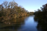
The French Broad River flows 213 miles (342.8 km) from near the village of
Rosman
Rosman, North Carolina
Rosman is a town in Transylvania County, North Carolina, United States. The population was 490 at the 2000 census. The northern terminus of U.S. Route 178 is less than one mile northwest of Rosman on U.S...

 in Transylvania County, North Carolina
Transylvania County, North Carolina
Transylvania County is a county located in the U.S. state of North Carolina. As of 2010, the population was 33,090. Its county seat is Brevard.- History :The county was formed in 1861 from parts of Henderson County and Jackson County...

, into the state of Tennessee
Tennessee
Tennessee is a U.S. state located in the Southeastern United States. It has a population of 6,346,105, making it the nation's 17th-largest state by population, and covers , making it the 36th-largest by total land area...

. Its confluence
Confluence
Confluence, in geography, describes the meeting of two or more bodies of water.Confluence may also refer to:* Confluence , a property of term rewriting systems...

 with the Holston River
Holston River
The Holston River is a major river system of southwestern Virginia and east Tennessee. The three major forks of the Holston rise in southwestern Virginia and have their confluence near Kingsport, Tennessee. The North Fork flows southwest from Sharon Springs in Bland County, Virginia...

 at Knoxville
Knoxville, Tennessee
Founded in 1786, Knoxville is the third-largest city in the U.S. state of Tennessee, U.S.A., behind Memphis and Nashville, and is the county seat of Knox County. It is the largest city in East Tennessee, and the second-largest city in the Appalachia region...

 is the beginning of the Tennessee River
Tennessee River
The Tennessee River is the largest tributary of the Ohio River. It is approximately 652 miles long and is located in the southeastern United States in the Tennessee Valley. The river was once popularly known as the Cherokee River, among other names...

.

The French Broad River was named by white settlers centuries
Century
A century is one hundred consecutive years. Centuries are numbered ordinally in English and many other languages .-Start and end in the Gregorian Calendar:...

 ago because it was one of the two broad rivers in western North Carolina. The one which flowed into land claimed by France at that time
New France
New France was the area colonized by France in North America during a period beginning with the exploration of the Saint Lawrence River by Jacques Cartier in 1534 and ending with the cession of New France to Spain and Great Britain in 1763...

 was named the "French Broad River", whereas the other, which stayed in land claimed by England
England
England is a country that is part of the United Kingdom. It shares land borders with Scotland to the north and Wales to the west; the Irish Sea is to the north west, the Celtic Sea to the south west, with the North Sea to the east and the English Channel to the south separating it from continental...

 – the Colony of North Carolina – was named the "English Broad River". (The latter was later renamed simply to the "Broad River"
Broad River (Carolinas)
The Broad River is a principal tributary of the Congaree River, about 150 miles long, in western North Carolina and northern South Carolina in the United States. Via the Congaree, it is part of the watershed of the Santee River, which flows to the Atlantic Ocean...

). The name of the French Broad River in French
French language
French is a Romance language spoken as a first language in France, the Romandy region in Switzerland, Wallonia and Brussels in Belgium, Monaco, the regions of Quebec and Acadia in Canada, and by various communities elsewhere. Second-language speakers of French are distributed throughout many parts...

 was the Agiqua River, but nobody seems to know what the Native Americans
Indigenous peoples of the Americas
The indigenous peoples of the Americas are the pre-Columbian inhabitants of North and South America, their descendants and other ethnic groups who are identified with those peoples. Indigenous peoples are known in Canada as Aboriginal peoples, and in the United States as Native Americans...

 of this area – the Cherokee Indians – called these two rivers. However, the Cherokees did name the Tennessee River.

The French Broad River begins just west of the Eastern Continental Divide
Eastern Continental Divide
The Eastern Continental Divide, in conjunction with other continental divides of North America, demarcates two watersheds of the Atlantic Ocean: the Gulf of Mexico watershed and the Atlantic Seaboard watershed. Prior to 1760, the divide represented the boundary between British and French colonial...

, and from there, it flows northeasterly through the Appalachian Mountains
Appalachian Mountains
The Appalachian Mountains #Whether the stressed vowel is or ,#Whether the "ch" is pronounced as a fricative or an affricate , and#Whether the final vowel is the monophthong or the diphthong .), often called the Appalachians, are a system of mountains in eastern North America. The Appalachians...

. The river follows a general northeasterly direction as it flows through Transylvania, Henderson
Henderson County, North Carolina
Henderson County is a county located in the U.S. state of North Carolina. It is part of the Asheville, North Carolina, Metropolitan Statistical Area. As of 2008, the population was 102,367. Its county seat is Hendersonville.- History :...

, and Buncombe
Buncombe County, North Carolina
-Demographics:As of the census of 2000, there were 206,330 people, 85,776 households, and 55,668 families residing in the county. The population density was 314 people per square mile . There were 93,973 housing units at an average density of 143 per square mile...

 counties. In Buncombe County, the river flows through the city of Asheville
Asheville, North Carolina
Asheville is a city in and the county seat of Buncombe County, North Carolina, United States. It is the largest city in Western North Carolina, and the 11th largest city in North Carolina. The City is home to the United States National Climatic Data Center , which is the world's largest active...

, where it receives the water of the Swannanoa River
Swannanoa River
The Swannanoa River flows through the Swannanoa Valley of western North Carolina, and is a major tributary to the French Broad River. It begins at its headwaters in Black Mountain, NC, however, it also has a major tributary near its headwaters: Flat Creek, which begins on the slopes of Mount...

. Downstream of Asheville, the river proceeds north through Madison County
Madison County, North Carolina
-Demographics:As of the census of 2000, there were 19,635 people, 8,000 households, and 5,592 families residing in the county. The population density was 44 people per square mile . There were 9,722 housing units at an average density of 22 per square mile...

, where it flows through its county seat of Marshall
Marshall, North Carolina
Marshall is a town in Madison County, North Carolina, United States. The population was 840 at the 2000 census. It is the county seat of Madison County.Marshall is part of the Asheville Metropolitan Statistical Area.-Geography:Marshall is located at ....

. Next, the French Broad River flows northwesterly into Tennessee.

In Cocke County, Tennessee, the French Broad River receives the waters of both the Pigeon River
Pigeon River (Tennessee - North Carolina)
The Pigeon River of western North Carolina and east Tennessee rises above Canton, North Carolina. Below this, it flows roughly parallel to Interstate 40 for many miles and is impounded by a dam -- Walters Dam -- belonging to Progress Energy before entering Tennessee, where it flows into the French...

 and the Nolichucky River
Nolichucky River
The Nolichucky River is a major stream draining the Blue Ridge Mountains of western North Carolina and east Tennessee. The river is long.-Hydrography:...

, after which the French Broad River is impounded behind Douglas Dam
Douglas Dam
Douglas Dam is a hydroelectric dam on the French Broad River in Sevier County, Tennessee, in the southeastern United States. The dam is operated by the Tennessee Valley Authority , which built the dam in record time in the early 1940s to meet emergency energy demands at the height of World War II...

, forming Douglas Lake
Douglas Lake
Douglas Lake, also called Douglas Reservoir, is a reservoir created by an impoundment of the French Broad River in Eastern Tennessee. This lake is located only a few miles from the Pigeon Forge/Gatlinburg area, and also the Great Smoky Mountains National Park...

. In Sevier County
Sevier County, Tennessee
Sevier County is a county of the state of Tennessee, United States. Its population was 71,170 at the 2000 United States Census. It is included in the Sevierville, Tennessee, Micropolitan Statistical Area, which is included in the Knoxville-Sevierville-La Follette, TN Combined Statistical Area. The...

, the French Broad River receives the flow of the Little Pigeon River
Little Pigeon River (Tennessee)
The Little Pigeon River is a river located entirely within Sevier County, Tennessee.It rises from a series of streams which flow together on the dividing ridge between the states of Tennessee and North Carolina inside the boundary of the Great Smoky Mountains National Park. The river is subdivided...

, and then it flows through a wide gap in Bays Mountain
Bays Mountain
Bays Mountain is a ridge of the Ridge-and-Valley Appalachians, located in eastern Tennessee. It runs southwest to northeast, from just south of Knoxville to Kingsport.Its southern segment is relatively low in elevation...

 before reaching the flatlands of Tennessee and joining with the Holston River at Knoxville.

The lower portion of the French Broad River is dominated by the major hydroelectric power dam and reservoirs which were built by the Tennessee Valley Authority
Tennessee Valley Authority
The Tennessee Valley Authority is a federally owned corporation in the United States created by congressional charter in May 1933 to provide navigation, flood control, electricity generation, fertilizer manufacturing, and economic development in the Tennessee Valley, a region particularly affected...

, and which is one of the larger TVA developments on a tributary of the Tennessee River. (The two other very large ones are Norris Lake
Norris Lake
Norris Lake may refer to:* Norris Lake, a Tennessee Valley Authority reservoir in Tennessee, impounded by Norris Dam* Lake Norris in Lake County, Florida...

 on the Clinch River
Clinch River
The Clinch River rises in Southwest Virginia near Tazewell, Virginia and flows southwest through the Great Appalachian Valley, gathering various tributaries including the Powell River before joining the Tennessee River in East Tennessee.-Course:...

 and Cherokee Lake on the Holston River.)

In 1987, the NC General Assembly established the French Broad River State Trail as a blueway
Blueway
A blueway or water trail is a water path or trail that is developed with launch points, camping locations and points of interest for canoeists and kayakers...

 which follows the river for 67 miles. The paddle trail is a part of North Carolina State Trails Program, which is a section of the NC Division of Parks and Recreation. A system of launch points locations were created along the river for the trail.

The portion of the French Broad River in Tennessee was designated a state scenic river by the Tennessee Scenic Rivers Act of 1968. Approximately 33 miles (53.1 km) of the river in Cocke County, starting at the North Carolina border and extending downstream to the place where it flows into Douglas Lake, are designated as a Class III, Partially Developed River.

Wilma Dykeman
Wilma Dykeman
Wilma Dykeman Stokely was an American writer of fiction and nonfiction whose works chronicled the people and land of Appalachia.-Biography:...

 wrote the book The French Broad (1955) about the river. The book brought public attention to concerns about the polluted
Water pollution
Water pollution is the contamination of water bodies . Water pollution occurs when pollutants are discharged directly or indirectly into water bodies without adequate treatment to remove harmful compounds....

 condition of parts of the river. Current conservation groups include The French Broad Riverkeeper. Facebook also hosts the French Broad Riverkeeper profile to list current river happenings.

Crossings


The following is a partial list of crossings of the French Broad from Brevard to the confluence with the Tennessee River.

North Carolina

  • Transylvania
    Transylvania County, North Carolina
    Transylvania County is a county located in the U.S. state of North Carolina. As of 2010, the population was 33,090. Its county seat is Brevard.- History :The county was formed in 1861 from parts of Henderson County and Jackson County...

     and Henderson
    Henderson County, North Carolina
    Henderson County is a county located in the U.S. state of North Carolina. It is part of the Asheville, North Carolina, Metropolitan Statistical Area. As of 2008, the population was 102,367. Its county seat is Hendersonville.- History :...

     counties
    • Patton Bridge
    • Crab Creek Road
    • Blantyre Road
    • Etowah School Road in Etowah
      Etowah, North Carolina
      Etowah is a census-designated place in Henderson County, North Carolina, United States. The population was 2,766 at the 2000 census. It is part of the Asheville Metropolitan Statistical Area.-Geography:Etowah is located at ....

    • McLean Bridge (U.S. 64) in Etowah
    • Johnson Bridge
    • Fannings Bridge
    • Butler Bridge
    • Kings Bridge
    • Boylston Highway (N.C. 280) at the Asheville Regional Airport
      Asheville Regional Airport
      Asheville Regional Airport is a Class C airport near Interstate 40 and Interstate 26 near the town of Fletcher, south of the city of Asheville, in the U.S. state of North Carolina. It is owned by the city of Asheville...

  • Buncombe County
    Buncombe County, North Carolina
    -Demographics:As of the census of 2000, there were 206,330 people, 85,776 households, and 55,668 families residing in the county. The population density was 314 people per square mile . There were 93,973 housing units at an average density of 143 per square mile...

    /Asheville
    Asheville, North Carolina
    Asheville is a city in and the county seat of Buncombe County, North Carolina, United States. It is the largest city in Western North Carolina, and the 11th largest city in North Carolina. The City is home to the United States National Climatic Data Center , which is the world's largest active...

    • Glenn Bridge
    • Long Shoals Bridge in Skyland
      Skyland, North Carolina
      Skyland is an unincorporated community in Buncombe County, North Carolina, United States. It is on U.S. Route 25, where North Carolina Highway 146 starts, east of Interstate 26. It is north of Royal Pines, south of Biltmore Forest, and a suburb of Asheville....

    • Blue Ridge Parkway
      Blue Ridge Parkway
      The Blue Ridge Parkway is a National Parkway and All-American Road in the United States, noted for its scenic beauty. It runs for 469 miles , mostly along the famous Blue Ridge, a major mountain chain that is part of the Appalachian Mountains...

    • Interstate 26
      Interstate 26
      Interstate 26 is a nominally east–west main route of the Interstate Highway System in the Southeastern United States. I-26 runs from the junction of U.S. Route 11W and U.S. Route 23 in Kingsport, Tennessee, generally southeastward to U.S. Route 17 in Charleston, South Carolina...

    • Interstate 40
      Interstate 40
      Interstate 40 is the third-longest major east–west Interstate Highway in the United States, after I-90 and I-80. Its western end is at Interstate 15 in Barstow, California; its eastern end is at a concurrency of U.S. Route 117 and North Carolina Highway 132 in Wilmington, North Carolina...

       at the Biltmore Estate
      Biltmore Estate
      Biltmore House is a Châteauesque-styled mansion near Asheville, North Carolina, built by George Washington Vanderbilt II between 1889 and 1895. It is the largest privately-owned home in the United States, at and featuring 250 rooms...

    • Carrier Bridge in Asheville
    • Haywood Road in Asheville
    • Smith Bridge in Asheville
    • Interstate 26
      Interstate 26
      Interstate 26 is a nominally east–west main route of the Interstate Highway System in the Southeastern United States. I-26 runs from the junction of U.S. Route 11W and U.S. Route 23 in Kingsport, Tennessee, generally southeastward to U.S. Route 17 in Charleston, South Carolina...

      /Interstate 240
      Interstate 240
      Interstate 240 may refer to:* Interstate 240 , a connection into Asheville, North Carolina* Interstate 240 , a freeway on the south side of Oklahoma City* Interstate 240 , a bypass of Memphis, Tennessee...

      /U.S. 19/U.S. 74 in Asheville
    • Pearson Bridge in Asheville
    • Old Leicester
      Leicester, North Carolina
      Leicester is an unincorporated community in Buncombe County, North Carolina ; although incorporating was proposed in 2007, the proposal never passed. Leicester is part of the Asheville Metropolitan Statistical Area. As of 2007, Leicester population is 12,514 people...

       Highway in Craggy
    • Fletcher Martin Road
  • Madison County
    • Two Bridges connecting Marshall
      Marshall, North Carolina
      Marshall is a town in Madison County, North Carolina, United States. The population was 840 at the 2000 census. It is the county seat of Madison County.Marshall is part of the Asheville Metropolitan Statistical Area.-Geography:Marshall is located at ....

       to Blennerhasset Island
    • Little Pine Road
    • Barnard Road in Barnard (put-in for Section 9 of the French Broad, a Class III-IV whitewater run that is the most frequently paddled section of the river)
    • (U.S. 25)/(U.S. 70) in Hot Springs
      Hot Springs, North Carolina
      Hot Springs is a town in Madison County, North Carolina, United States. The population was 645 at the 2000 census. It is part of the Asheville Metropolitan Statistical Area.-Geography:Hot Springs is located at ....

       (takeout for Section 9)

Tennessee

  • Cocke County
    • Wolf Creek Bridge
    • Bridge in Del Rio
      Del Rio, Tennessee
      Del Rio is an unincorporated community in Cocke County, Tennessee, United States. Although it is not a census-designated place, the ZIP Code Tabulation Area for the ZIP Code that serves Del Rio had a population of 2,138, according to the 2000 census....

    • James T Huff Bridge (U.S. 25/U.S. 70)
    • U.S. 321 in Newport
      Newport, Tennessee
      Newport is a city in Cocke County, Tennessee, United States. The population was 7,242 at the 2000 census. It is the county seat of Cocke County.-Geography:...

    • Holt Town Road
    • Highway 25E from Cocke County into Jefferson County)
  • Douglas Lake to Knoxville
    Knoxville, Tennessee
    Founded in 1786, Knoxville is the third-largest city in the U.S. state of Tennessee, U.S.A., behind Memphis and Nashville, and is the county seat of Knox County. It is the largest city in East Tennessee, and the second-largest city in the Appalachia region...

    • Interstate 40
      Interstate 40
      Interstate 40 is the third-longest major east–west Interstate Highway in the United States, after I-90 and I-80. Its western end is at Interstate 15 in Barstow, California; its eastern end is at a concurrency of U.S. Route 117 and North Carolina Highway 132 in Wilmington, North Carolina...

       and Swann Bridge (U.S. 70) over Douglas Lake
      Douglas Lake
      Douglas Lake, also called Douglas Reservoir, is a reservoir created by an impoundment of the French Broad River in Eastern Tennessee. This lake is located only a few miles from the Pigeon Forge/Gatlinburg area, and also the Great Smoky Mountains National Park...

    • James D. Hoskins Bridge in Dandridge
      Dandridge, Tennessee
      Dandridge is a town in Jefferson County, Tennessee, United States. It is the county seat of Jefferson County. It is part of the Morristown, Tennessee Metropolitan Statistical Area....

    • Douglas Dam
      Douglas Dam
      Douglas Dam is a hydroelectric dam on the French Broad River in Sevier County, Tennessee, in the southeastern United States. The dam is operated by the Tennessee Valley Authority , which built the dam in record time in the early 1940s to meet emergency energy demands at the height of World War II...

       Road
    • TN 66 at Sevierville
      Sevierville, Tennessee
      Sevierville is a city in Sevier County, Tennessee, located in the Southeastern United States. Its population was 11,757 at the 2000 United States Census; in 2004 the estimated population was 14,101. Sevierville is the county seat of Sevier County, Tennessee....

    • Several golf cart path bridges over the Cain Islands
    • Doctor JH Gammondale Bridge in Marbledale

See also

  • List of North Carolina rivers
  • List of Tennessee rivers
  • Wilma Dykeman RiverWay Plan
    Wilma Dykeman RiverWay Plan
    The Wilma Dykeman RiverWay Plan is RiverLink's design to redevelop the urban riverfront corridor of the U.S. City of Asheville, as a demonstration project for the entire French Broad River watershed by connecting a Greenway System along the French Broad and Swannanoa Rivers...

     (for RiverLink's sustainable greenways and park developments on/near the French Broad River)

External links