
List of Category 5 Atlantic hurricanes
Encyclopedia

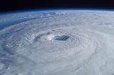
Tropical cyclone
A tropical cyclone is a storm system characterized by a large low-pressure center and numerous thunderstorms that produce strong winds and heavy rain. Tropical cyclones strengthen when water evaporated from the ocean is released as the saturated air rises, resulting in condensation of water vapor...
s that reached Category 5 intensity on the Saffir–Simpson Hurricane Scale within the Atlantic Ocean
Atlantic Ocean
The Atlantic Ocean is the second-largest of the world's oceanic divisions. With a total area of about , it covers approximately 20% of the Earth's surface and about 26% of its water surface area...
(north of the equator
Equator
An equator is the intersection of a sphere's surface with the plane perpendicular to the sphere's axis of rotation and containing the sphere's center of mass....
), the Caribbean Sea
Caribbean Sea
The Caribbean Sea is a sea of the Atlantic Ocean located in the tropics of the Western hemisphere. It is bounded by Mexico and Central America to the west and southwest, to the north by the Greater Antilles, and to the east by the Lesser Antilles....
and Gulf of Mexico
Gulf of Mexico
The Gulf of Mexico is a partially landlocked ocean basin largely surrounded by the North American continent and the island of Cuba. It is bounded on the northeast, north and northwest by the Gulf Coast of the United States, on the southwest and south by Mexico, and on the southeast by Cuba. In...
. They are the most catastrophic hurricanes that can form on planet Earth. They are relatively rare in the Atlantic Ocean, and generally occur only about once every three years on average in the Atlantic basin.
Northern Hemisphere
The Northern Hemisphere is the half of a planet that is north of its equator—the word hemisphere literally means “half sphere”. It is also that half of the celestial sphere north of the celestial equator...
's mid-latitudes. This is caused by the westerlies
Westerlies
The Westerlies, anti-trades, or Prevailing Westerlies, are the prevailing winds in the middle latitudes between 30 and 60 degrees latitude, blowing from the high pressure area in the horse latitudes towards the poles. These prevailing winds blow from the west to the east, and steer extratropical...
, which recurve strong hurricanes towards colder waters in the open Atlantic Ocean. However, the easterly large-scale surface winds
Trade wind
The trade winds are the prevailing pattern of easterly surface winds found in the tropics, within the lower portion of the Earth's atmosphere, in the lower section of the troposphere near the Earth's equator...
in the tropics may steer strong hurricanes in the Caribbean Sea towards land areas.
Only four times—in the 1960
1960 Atlantic hurricane season
The 1960 Atlantic hurricane season was the least active Atlantic hurricane season since 1952. The season officially began on June 15, 1960, and lasted until November 15, 1960. These dates conventionally delimit the period of each year when most tropical cyclones form in the Atlantic basin...
, 1961
1961 Atlantic hurricane season
The 1961 Atlantic hurricane season officially began on June 15, 1961, and lasted until November 15, 1961. These dates conventionally delimit the period of each year when most tropical cyclones form in the Atlantic basin. The season had seven major hurricanes, the second highest number on...
, 2005
2005 Atlantic hurricane season
The 2005 Atlantic hurricane season was the most active Atlantic hurricane season in recorded history, repeatedly shattering numerous records. The impact of the season was widespread and ruinous with an estimated 3,913 deaths and record damage of about $159.2 billion...
and 2007
2007 Atlantic hurricane season
The 2007 Atlantic hurricane season was an active Atlantic hurricane season that produced 17 tropical cyclones, 15 tropical storms, six hurricanes, and two major hurricanes. It officially started on June 1 and ended on November 30, dates which conventionally delimit the...
hurricane seasons—have multiple Category 5 hurricanes formed. Only in 2005 have more than two Category 5 storms formed, and only in 2007 has more than one made landfall at Category 5 strength.
Statistics
Maximum sustained wind
The maximum sustained winds associated with a tropical cyclone are a common indicator of the intensity of the storm. Within a mature tropical cyclone, they are found within the eyewall at a distance defined as the radius of maximum wind, or RMW. Unlike gusts, the value of these winds are...
" refers to the average wind speed observed over one minute at 10 metre above ground, which is the standard height windspeed is measured at to avoid interference by obstacles and obstructions. Brief gusts in hurricanes are typically up to 50 percent higher than sustained winds. Because a hurricane is (usually) a moving system, the wind field is asymmetric, with the strongest winds on the right side (in the Northern Hemisphere
Northern Hemisphere
The Northern Hemisphere is the half of a planet that is north of its equator—the word hemisphere literally means “half sphere”. It is also that half of the celestial sphere north of the celestial equator...
), relative to the direction of motion. The highest winds given in advisories are those from the right side.
Between 1924
1924 Atlantic hurricane season
The 1924 Atlantic hurricane season ran through the summer and the first half of fall in 1924. The season was average with 11 storms; three became hurricanes and two others became major hurricanes. An early season tropical storm hit Belize on June 18 and Mexico on June 21...
and 2007
2007 Atlantic hurricane season
The 2007 Atlantic hurricane season was an active Atlantic hurricane season that produced 17 tropical cyclones, 15 tropical storms, six hurricanes, and two major hurricanes. It officially started on June 1 and ended on November 30, dates which conventionally delimit the...
, 32 hurricanes were recorded at Category 5 strength. No Category 5 hurricanes were observed officially before 1924. It can be presumed that earlier storms reached Category 5 strength over open waters, but the strongest winds were not measured. The anemometer
Anemometer
An anemometer is a device for measuring wind speed, and is a common weather station instrument. The term is derived from the Greek word anemos, meaning wind, and is used to describe any airspeed measurement instrument used in meteorology or aerodynamics...
, a device
A reanalysis
Atlantic hurricane reanalysis
Atlantic hurricane reanalysis is an ongoing project within the National Oceanic and Atmospheric Administration which seeks to correct and add new information about past Atlantic tropical cyclones...
of weather data is ongoing by researchers who may upgrade or downgrade other Atlantic hurricanes currently listed at Categories 4 and 5. For example, the 1825 Santa Ana hurricane is suspected to have reached Category 5 strength. Furthermore, paleotempestological
Paleotempestology
Paleotempestology is the study of past tropical cyclone activity by means of geological proxies as well as historical documentary records. The term was coined by Kerry Emanuel.-Sedimentary proxy records:...
research aims to identify past major hurricanes by comparing sedimentary evidence of recent and past hurricane strikes. For example, a “giant hurricane” significantly more powerful than Hurricane Hattie
Hurricane Hattie
Hurricane Hattie was the deadliest tropical cyclone of the 1961 Atlantic hurricane season, as well as the strongest, reaching a peak intensity equivalent to Category 5 hurricane intensity...
(Category 5) has been identified in Belize
Belize
Belize is a constitutional monarchy and the northernmost country in Central America. Belize has a diverse society, comprising many cultures and languages. Even though Kriol and Spanish are spoken among the population, Belize is the only country in Central America where English is the official...
an sediment, having struck the region sometime before 1500.
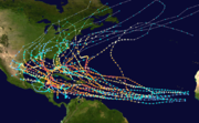
Officially, the decade with the most Category 5 hurricanes is 2000–2009, with eight Category 5 hurricanes having occurred: Isabel (2003), Ivan (2004), Emily (2005), Katrina (2005), Rita (2005), Wilma (2005), Dean (2007), and Felix (2007).
The previous decade with the most Category 5 hurricanes was the 1960s, with six occurring between 1960 and 1969. (Ethel, Donna, Carla, Hattie, Beulah, and Camille).
Six Atlantic hurricanes—Allen
Hurricane Allen
Hurricane Allen was the first and strongest hurricane of the 1980 Atlantic hurricane season. It was one of the strongest hurricanes in recorded history, one of the few hurricanes to reach Category 5 status on the Saffir-Simpson Hurricane Scale on three separate occasions, and spent more time...
, Andrew
Hurricane Andrew
Hurricane Andrew was the third Category 5 hurricane to make landfall in the United States, after the Labor Day Hurricane of 1935 and Hurricane Camille in 1969. Andrew was the first named storm and only major hurricane of the otherwise inactive 1992 Atlantic hurricane season...
, Isabel
Hurricane Isabel
Hurricane Isabel was the costliest and deadliest hurricane in the 2003 Atlantic hurricane season. The ninth named storm, fifth hurricane, and second major hurricane of the season, Isabel formed near the Cape Verde Islands from a tropical wave on September 6 in the tropical Atlantic Ocean...
, Ivan
Hurricane Ivan
Hurricane Ivan was a large, long-lived, Cape Verde-type hurricane that caused widespread damage in the Caribbean and United States. The cyclone was the ninth named storm, the sixth hurricane and the fourth major hurricane of the active 2004 Atlantic hurricane season...
, Dean and Felix—have reached Category 5 intensity on more than one occasion; that is, by reaching Category 5 intensity, weakening to a Category 4 or lower, and then becoming a Category 5 again. Such hurricanes have their dates shown together. However, no Atlantic hurricane has reached Category 5 intensity more than three times, as Allen, Isabel and Ivan each reached that intensity on three separate occasions. Andrew, Dean and Felix are the only other storms to have reached Category 5 on multiple occasions, each doing it twice. Hurricane Allen holds the record for most overall time spent as a Category 5, while Hurricanes Dog and Ivan hold the record for most time spent consecutively as a Category 5.
The minimum pressure
Atmospheric pressure
Atmospheric pressure is the force per unit area exerted into a surface by the weight of air above that surface in the atmosphere of Earth . In most circumstances atmospheric pressure is closely approximated by the hydrostatic pressure caused by the weight of air above the measurement point...
of the more recent systems was measured by recon aircraft using dropsonde
Dropsonde
A dropsonde is a weather reconnaissance device created by the National Center for Atmospheric Research , designed to be dropped from an aircraft at altitude to more accurately measure tropical storm conditions as the device falls to the surface...
s, or by determining it from satellite imagery using the Dvorak technique
Dvorak technique
The Dvorak technique is a widely used system to subjectively estimate tropical cyclone intensity based solely on visible and infrared satellite images. Several agencies issue Dvorak intensity numbers for cyclones of sufficient intensity...
. For older storms, pressures are often incomplete. The only readings came from ship reports, land observations, or aircraft reconnaissance. None of these methods can provide constant pressure measurements. Thus, sometimes the only measurement can be from when the hurricane was not a Category 5. Consequently, the lowest measurement is sometimes unrealistically high for a Category 5 hurricane.
These pressure values do not match up with the wind readings. This happens because the wind speed of a hurricane depends on both its size and how rapidly the pressure drops as the hurricane's center approaches. Thus, a hurricane in an environment of high ambient pressure will have stronger winds than a hurricane in an environment of low ambient pressure, even if they have identical central pressures.
Category 5 Atlantic hurricanes


| Storm name | |Season | |Dates as a Category 5 | |Time as a Category 5 | |Peak one-minute sustained winds | |Pressure (hPa & inHg) |
|
|---|---|---|---|---|---|---|
| 1924 1924 Atlantic hurricane season The 1924 Atlantic hurricane season ran through the summer and the first half of fall in 1924. The season was average with 11 storms; three became hurricanes and two others became major hurricanes. An early season tropical storm hit Belize on June 18 and Mexico on June 21... |
12 12 hours | 165 mph (270 km/h) | abbr=on 910 | |||
| 1928 1928 Atlantic hurricane season The 1928 Atlantic hurricane season ran through the summer and the first half of fall in 1928. The season was not active, but eventful. Six tropical cyclones formed during the season. Four of those became hurricanes. Only one became a major hurricane, which was also a Category 5 hurricane.-Hurricane... |
12 12 hours | 160 mph (260 km/h) | abbr=on 929 | |||
| 1932 1932 Atlantic hurricane season The 1932 Atlantic hurricane season ran through the summer and the first half of fall in 1932. The 1932 season was an active one. An early tropical storm formed in May and hit Hispaniola, causing minimal damage. A Category 4 struck Galveston, Texas and the Galveston Seawall proved its worth. A... |
24 24 hours | 160 mph (260 km/h) | abbr=on 931 | |||
| 1935 1935 Atlantic hurricane season The 1935 Atlantic hurricane season ran from June 16 through October 31, 1935. The 1935 season featured below average activity, but it was eventful. A Category 1 hurricane in the Caribbean killed an estimated 2,150 people in the Greater Antilles and Central America. A Category 3 storm hit... |
6 6 hours | 185 mph (295 km/h) | abbr=on 892 | |||
| 1938 1938 Atlantic hurricane season The 1938 Atlantic hurricane season officially began on June 16, 1938, and lasted until October 31, 1938. These dates conventionally delimit the period of each year when most tropical cyclones form in the Atlantic basin.-Tropical Storm One:... |
18 18 hours | 160 mph (260 km/h) | abbr=on 938 | |||
| 1947 1947 Atlantic hurricane season The 1947 Atlantic hurricane season officially began on June 16, 1947, and lasted until November 1, 1947. These dates conventionally delimit the period of each year when most tropical cyclones form in the Atlantic basin.... |
30 30 hours | 160 mph (260 km/h) | abbr=on 929 | |||
| Dog Hurricane Dog (1950) Hurricane Dog was the most intense hurricane in the 1950 Atlantic hurricane season. The fourth named storm of the season, Dog developed on August 30 to the east of Antigua; after passing through the northern Lesser Antilles, it turned to the north and intensified into a Category 5 hurricane... |
1950 1950 Atlantic hurricane season The 1950 Atlantic hurricane season was the first year in which tropical cyclones were given official names in the Atlantic basin. Names were taken from the Joint Army/Navy Phonetic Alphabet, with the first named storm being designated "Able", the second "Baker", and so on. It was an active season... |
60 60 hours | 185 mph (295 km/h) | abbr=on 948 | ||
| Easy Hurricane Easy (1951) Hurricane Easy was the strongest tropical cyclone of the 1951 Atlantic hurricane season. It was a Cape Verde-type hurricane that recurved away from land masses. The fifth tropical cyclone, fourth hurricane, and fourth major hurricane of the season, Easy formed 1,000 miles west of Cape Verde... |
1951 1951 Atlantic hurricane season The 1951 Atlantic hurricane season was moderately active, starting with an pre-season hurricane and lasting until late October. The season officially started on June 15, when the United States Weather Bureau began its daily monitoring for tropical cyclone activity; the season officially ended... |
18 18 hours | 160 mph (260 km/h) | abbr=on 957 | ||
| Janet Hurricane Janet Hurricane Janet was the most powerful hurricane of the 1955 Atlantic hurricane season and one of the strongest Atlantic hurricanes on record. It made landfall as a Category 5 hurricane on the Saffir-Simpson Hurricane Scale, causing catastrophic damage and at least 687 deaths in the Lesser... |
1955 1955 Atlantic hurricane season The 1955 Atlantic hurricane season officially began on June 15, 1955, and lasted until November 15, 1955. These dates conventionally delimit the period of each year when most tropical cyclones form in the Atlantic basin. The 1955 season was active, with twelve tropical storms forming.Three... |
18 18 hours | 175 mph (280 km/h) | abbr=on 914 | ||
| Cleo Hurricane Cleo (1958) Hurricane Cleo was the strongest Atlantic hurricane of the 1958 Atlantic hurricane season. It remains one of only three Category 5 hurricanes to avoid land in the historical database–the others were Dog of 1950 and Easy of 1951. The third tropical cyclone, first hurricane, and first major hurricane... |
1958 1958 Atlantic hurricane season The 1958 Atlantic hurricane season officially began on June 15, 1958, and lasted until November 15, 1958. These dates conventionally delimit the period of each year when most tropical cyclones form in the Atlantic basin... |
6 6 hours | 160 mph (260 km/h) | abbr=on 948 | ||
| Donna Hurricane Donna Hurricane Donna in the 1960 Atlantic hurricane season was a Cape Verde-type hurricane which moved across the Leeward Islands, Puerto Rico, Hispanola, Cuba, The Bahamas, and every state on the East Coast of the United States... |
1960 1960 Atlantic hurricane season The 1960 Atlantic hurricane season was the least active Atlantic hurricane season since 1952. The season officially began on June 15, 1960, and lasted until November 15, 1960. These dates conventionally delimit the period of each year when most tropical cyclones form in the Atlantic basin... |
12 12 hours | 160 mph (260 km/h) | abbr=on 932 | ||
| Ethel | 1960 1960 Atlantic hurricane season The 1960 Atlantic hurricane season was the least active Atlantic hurricane season since 1952. The season officially began on June 15, 1960, and lasted until November 15, 1960. These dates conventionally delimit the period of each year when most tropical cyclones form in the Atlantic basin... |
6 6 hours | 160 mph (260 km/h) | abbr=on 972 | ||
| Carla Hurricane Carla Hurricane Carla was one of two Category 5 tropical cyclones during the 1961 Atlantic hurricane season. It struck the Texas coast as a Category 4 hurricane, becoming one of the most powerful storms to ever strike the United States. Hurricane Carla was the second most intense storm to ever... |
1961 1961 Atlantic hurricane season The 1961 Atlantic hurricane season officially began on June 15, 1961, and lasted until November 15, 1961. These dates conventionally delimit the period of each year when most tropical cyclones form in the Atlantic basin. The season had seven major hurricanes, the second highest number on... |
18 18 hours | 175 mph (280 km/h) | abbr=on 932 | ||
| Hattie Hurricane Hattie Hurricane Hattie was the deadliest tropical cyclone of the 1961 Atlantic hurricane season, as well as the strongest, reaching a peak intensity equivalent to Category 5 hurricane intensity... |
1961 1961 Atlantic hurricane season The 1961 Atlantic hurricane season officially began on June 15, 1961, and lasted until November 15, 1961. These dates conventionally delimit the period of each year when most tropical cyclones form in the Atlantic basin. The season had seven major hurricanes, the second highest number on... |
18 18 hours | 160 mph (260 km/h) | abbr=on 920 | ||
| Beulah Hurricane Beulah Hurricane Beulah was the second tropical storm, second hurricane, and only major hurricane during the 1967 Atlantic hurricane season. It tracked through the Caribbean, struck the Yucatán peninsula of Mexico as a major hurricane, and moved west-northwest into the Gulf of Mexico, briefly gaining... |
1967 1967 Atlantic hurricane season The 1967 Atlantic hurricane season was the first year in which the National Hurricane Center was in operation. The season began on June 1, which was the date when the NHC activated radar stations across the Caribbean and Gulf of Mexico... |
18 18 hours | 160 mph (260 km/h) | abbr=on 923 | ||
| Camille Hurricane Camille Hurricane Camille was the third and strongest tropical cyclone and second hurricane during the 1969 Atlantic hurricane season. The second of three catastrophic Category 5 hurricanes to make landfall in the United States during the 20th century , which it did near the mouth of the Mississippi River... |
1969 1969 Atlantic hurricane season The 1969 Atlantic hurricane season officially began on June 1, 1969, and lasted until November 30, 1969. These dates conventionally delimit the period of each year when most tropical cyclones form in the Atlantic basin. The season was among the most active on record, with 18 tropical cyclones, 12... |
18 18 hours | 190 mph (305 km/h) | abbr=on 905 | ||
| Edith | 1971 1971 Atlantic hurricane season The 1971 Atlantic hurricane season was fairly active with several notable storms. Hurricane Edith, the strongest of the season, was a Category 5 on the Saffir-Simpson scale, the highest category on the scale. It struck Nicaragua at peak intensity, killing dozens, and later hit southern Louisiana... |
6 6 hours | 160 mph (260 km/h) | abbr=on 943 | ||
| Anita Hurricane Anita Hurricane Anita was a powerful Atlantic hurricane during an otherwise quiet 1977 Atlantic hurricane season. The first tropical cyclone of the season, Anita developed from a tropical wave on August 29 in the north-central Gulf of Mexico. It tracked westward into an area with conditions favorable for... |
1977 1977 Atlantic hurricane season The 1977 Atlantic hurricane season officially began on June 1, 1977, and lasted until November 30, 1977. These dates conventionally delimit the period of each year when most tropical cyclones form in the Atlantic basin.... |
12 12 hours | 175 mph (280 km/h) | abbr=on 926 | ||
| David Hurricane David Hurricane David was the fourth named tropical cyclone, second hurricane, and first major hurricane of the 1979 Atlantic hurricane season. A Category 5 hurricane on the Saffir-Simpson Hurricane Scale, David was among the deadliest hurricanes in the latter half of the 20th century, killing... |
1979 1979 Atlantic hurricane season The 1979 Atlantic hurricane season was the first in which the Atlantic hurricane naming list included both male and female names. It officially began on June 1 and lasted until November 30, and there was tropical cyclone activity in every month. The dates conventionally delimit the period of each... |
42 42 hours | 175 mph (280 km/h) | abbr=on 924 | ||
| Allen Hurricane Allen Hurricane Allen was the first and strongest hurricane of the 1980 Atlantic hurricane season. It was one of the strongest hurricanes in recorded history, one of the few hurricanes to reach Category 5 status on the Saffir-Simpson Hurricane Scale on three separate occasions, and spent more time... |
1980 1980 Atlantic hurricane season The 1980 Atlantic hurricane season officially began on June 1, 1980, and lasted until November 30, 1980. These dates conventionally delimit the period of each year when most tropical cyclones form in the Atlantic basin. The season was fairly active, with eleven storms forming, of which nine reached... |
72 72 hours | 190 mph (305 km/h) | abbr=on 899 | ||
| Gilbert Hurricane Gilbert Hurricane Gilbert was an extremely powerful Cape Verde-type hurricane that formed during the 1988 Atlantic hurricane season and created widespread destruction in the Caribbean Sea and the Gulf of Mexico. It is the second most intense hurricane ever observed in the Atlantic basin behind only... |
1988 1988 Atlantic hurricane season The 1988 Atlantic hurricane season was a moderately active season that proved costly and deadly, with 15 tropical cyclones directly affecting land. The season officially began on June 1, 1988, and lasted until November 30, 1988, although activity began on May 30 when a tropical... |
24 24 hours | 185 mph (295 km/h) | abbr=on 888 | ||
| Hugo Hurricane Hugo Hurricane Hugo was a classical, destructive and rare Cape Verde-type hurricane which struck the Caribbean islands of Guadeloupe, Montserrat, St. Croix, Puerto Rico and the USA mainland in South Carolina as a Category 4 hurricane during September of the 1989 Atlantic hurricane season... |
1989 1989 Atlantic hurricane season The 1989 Atlantic hurricane season was an active season that produced fifteen tropical cyclones, eleven named storms, seven hurricanes, and two major hurricanes. The season was officially designated from June 1, 1989, to November 30, 1989, dates which conventionally... |
6 6 hours | 160 mph (260 km/h) | abbr=on 918 | ||
| Andrew Hurricane Andrew Hurricane Andrew was the third Category 5 hurricane to make landfall in the United States, after the Labor Day Hurricane of 1935 and Hurricane Camille in 1969. Andrew was the first named storm and only major hurricane of the otherwise inactive 1992 Atlantic hurricane season... |
1992 1992 Atlantic hurricane season The 1992 Atlantic hurricane season had one of the latest dates on record for the first named storm. The season officially began on June 1, 1992, and lasted until November 30, 1992. It was the least active hurricane season in nine years due to a strong El Niño... |
16 16 hours | 175 mph (280 km/h) | abbr=on 922 | ||
| Mitch Hurricane Mitch Hurricane Mitch was the most powerful hurricane and the most destructive of the 1998 Atlantic hurricane season, with maximum sustained winds of 180 mph . The storm was the thirteenth tropical storm, ninth hurricane, and third major hurricane of the season. Along with Hurricane Georges, Mitch... |
1998 1998 Atlantic hurricane season The 1998 Atlantic hurricane season officially began on June 1, 1998, and lasted until November 30, 1998. These dates conventionally delimit the period of each year when most tropical cyclones form in the Atlantic basin; however, the season extended through December 1 as Hurricane Nicole remained... |
42 42 hours | 180 mph (285 km/h) | abbr=on 905 | ||
| Isabel Hurricane Isabel Hurricane Isabel was the costliest and deadliest hurricane in the 2003 Atlantic hurricane season. The ninth named storm, fifth hurricane, and second major hurricane of the season, Isabel formed near the Cape Verde Islands from a tropical wave on September 6 in the tropical Atlantic Ocean... |
2003 2003 Atlantic hurricane season The 2003 Atlantic hurricane season was an active Atlantic hurricane season with tropical activity before and after the official bounds of the season – the first such occurrence in 50 years. The season produced 21 tropical cyclones, of which 16 developed into named storms; seven... |
42 42 hours | 165 mph (270 km/h) | abbr=on 915 | ||
| Ivan Hurricane Ivan Hurricane Ivan was a large, long-lived, Cape Verde-type hurricane that caused widespread damage in the Caribbean and United States. The cyclone was the ninth named storm, the sixth hurricane and the fourth major hurricane of the active 2004 Atlantic hurricane season... |
2004 2004 Atlantic hurricane season The 2004 Atlantic hurricane season officially began on June 1, 2004, and lasted until November 30, 2004. These dates conventionally delimit the period of each year when most tropical cyclones form in the Atlantic basin... |
60 60 hours | 165 mph (270 km/h) | abbr=on 910 | ||
| Emily Hurricane Emily (2005) Hurricane Emily was a powerful, early season tropical cyclone that caused significant damage across the Caribbean Sea to Mexico. A Cape Verde-type hurricane, the storm formed on July 10, 2005, in the central Atlantic Ocean before passing through the Windward Islands on July 14... |
2005 2005 Atlantic hurricane season The 2005 Atlantic hurricane season was the most active Atlantic hurricane season in recorded history, repeatedly shattering numerous records. The impact of the season was widespread and ruinous with an estimated 3,913 deaths and record damage of about $159.2 billion... |
6 6 hours | 160 mph (260 km/h) | abbr=on 929 | ||
| Katrina Hurricane Katrina Hurricane Katrina of the 2005 Atlantic hurricane season was a powerful Atlantic hurricane. It is the costliest natural disaster, as well as one of the five deadliest hurricanes, in the history of the United States. Among recorded Atlantic hurricanes, it was the sixth strongest overall... |
2005 2005 Atlantic hurricane season The 2005 Atlantic hurricane season was the most active Atlantic hurricane season in recorded history, repeatedly shattering numerous records. The impact of the season was widespread and ruinous with an estimated 3,913 deaths and record damage of about $159.2 billion... |
18 18 hours | 175 mph (280 km/h) | abbr=on 902 | ||
| Rita Hurricane Rita Hurricane Rita was the fourth-most intense Atlantic hurricane ever recorded and the most intense tropical cyclone ever observed in the Gulf of Mexico. Rita caused $11.3 billion in damage on the U.S. Gulf Coast in September 2005... |
2005 2005 Atlantic hurricane season The 2005 Atlantic hurricane season was the most active Atlantic hurricane season in recorded history, repeatedly shattering numerous records. The impact of the season was widespread and ruinous with an estimated 3,913 deaths and record damage of about $159.2 billion... |
24 24 hours | 180 mph (285 km/h) | abbr=on 895 | ||
| Wilma Hurricane Wilma Hurricane Wilma was the most intense tropical cyclone ever recorded in the Atlantic basin. Wilma was the twenty-second storm , thirteenth hurricane, sixth major hurricane, and fourth Category 5 hurricane of the record-breaking 2005 season... |
2005 2005 Atlantic hurricane season The 2005 Atlantic hurricane season was the most active Atlantic hurricane season in recorded history, repeatedly shattering numerous records. The impact of the season was widespread and ruinous with an estimated 3,913 deaths and record damage of about $159.2 billion... |
18 18 hours | 185 mph (295 km/h) | abbr=on 882 | ||
| Dean Hurricane Dean The name Dean was used for five tropical cyclones in the Northern Atlantic Ocean:*1983's Tropical Storm Dean, which struck the coast of Virginia, causing minor erosion and flooding... |
2007 2007 Atlantic hurricane season The 2007 Atlantic hurricane season was an active Atlantic hurricane season that produced 17 tropical cyclones, 15 tropical storms, six hurricanes, and two major hurricanes. It officially started on June 1 and ended on November 30, dates which conventionally delimit the... |
24 24 hours | 175 mph (280 km/h) | abbr=on 905 | ||
| Felix Hurricane Felix The name Felix was used for four tropical cyclones in the Atlantic Ocean.* 1989's Hurricane Felix - A Category 1 storm that dissipated in the Atlantic without threatening land.... |
2007 2007 Atlantic hurricane season The 2007 Atlantic hurricane season was an active Atlantic hurricane season that produced 17 tropical cyclones, 15 tropical storms, six hurricanes, and two major hurricanes. It officially started on June 1 and ended on November 30, dates which conventionally delimit the... |
24 24 hours | 175 mph (280 km/h) | abbr=on 929 | ||
| Reference= †= Attained Category 5 status more than once | ||||||
Climatology
Atlantic Basin
The Atlantic Basin is the Atlantic Ocean.Atlantic Basin may also refer to:* Atlantic Basin Iron Works, an ironworks that operated in Brooklyn, New York, in the early to mid-20th century...
since 1851, when records began. Only one Category 5 has been recorded in July, seven in August, twenty in September, and four in October. There have been no officially recorded June, November or off-season Category 5 hurricanes.
The July and August Category 5s reached their high intensities in both the Gulf of Mexico
Gulf of Mexico
The Gulf of Mexico is a partially landlocked ocean basin largely surrounded by the North American continent and the island of Cuba. It is bounded on the northeast, north and northwest by the Gulf Coast of the United States, on the southwest and south by Mexico, and on the southeast by Cuba. In...
and the Caribbean Sea
Caribbean Sea
The Caribbean Sea is a sea of the Atlantic Ocean located in the tropics of the Western hemisphere. It is bounded by Mexico and Central America to the west and southwest, to the north by the Greater Antilles, and to the east by the Lesser Antilles....
. These are the areas most favorable for tropical cyclone development in those months.
September sees the most Category 5 hurricanes. This coincides with the climatological peak of the Atlantic hurricane season, which occurs in early September.
September Category 5s reached their strengths in any of the Gulf of Mexico
Gulf of Mexico
The Gulf of Mexico is a partially landlocked ocean basin largely surrounded by the North American continent and the island of Cuba. It is bounded on the northeast, north and northwest by the Gulf Coast of the United States, on the southwest and south by Mexico, and on the southeast by Cuba. In...
, Caribbean Sea
Caribbean Sea
The Caribbean Sea is a sea of the Atlantic Ocean located in the tropics of the Western hemisphere. It is bounded by Mexico and Central America to the west and southwest, to the north by the Greater Antilles, and to the east by the Lesser Antilles....
, and open Atlantic. These places are where September tropical cyclones are likely to form. Many of these hurricanes are either Cape Verde-type storms
Cape Verde-type hurricane
A Cape Verde-type hurricane is an Atlantic hurricane that develops near the Cape Verde islands, off the west coast of Africa. The average hurricane season has about two Cape Verde-type hurricanes, which are usually the largest and most intense storms of the season because they often have plenty of...
, which develop their strength by having a great deal of open water; or so-called Bahama busters, which intensify over the warm Loop Current
Loop Current
A parent to the Florida Current, the Loop Current is a warm ocean current in the Gulf of Mexico that flows northward between Cuba and the Yucatán peninsula, moves north into the Gulf of Mexico, loops east and south before exiting to the east through the Florida Straits and joining the Gulf Stream.A...
in the Gulf of Mexico.
All four October Category 5s reached their intensities in the western Caribbean, a region that Atlantic hurricanes strongly gravitate toward late in the season. This is due to the climatology of the area, which sometimes has a high-altitude anticyclone
Anticyclone
An anticyclone is a weather phenomenon defined by the United States' National Weather Service's glossary as "[a] large-scale circulation of winds around a central region of high atmospheric pressure, clockwise in the Northern Hemisphere, counterclockwise in the Southern Hemisphere"...
that promotes rapid intensification late in the season, as well as warm waters. Originally, there were only three Category 5s discovered in October, but reanalysis found out that a Hurricane
1924 Cuba hurricane
The 1924 Cuba hurricane is the earliest officially classified Category 5 Atlantic hurricane on the Saffir–Simpson scale. It formed on October 14 in the western Caribbean Sea, slowly organizing as it tracked northwestward. By October 16, it attained hurricane status to the east of the...
in 1924 also reached that intensity during the month, so four Category 5s developed in October.
Landfalls

Hurricane Dog (1950)
Hurricane Dog was the most intense hurricane in the 1950 Atlantic hurricane season. The fourth named storm of the season, Dog developed on August 30 to the east of Antigua; after passing through the northern Lesser Antilles, it turned to the north and intensified into a Category 5 hurricane...
, Easy
Hurricane Easy (1951)
Hurricane Easy was the strongest tropical cyclone of the 1951 Atlantic hurricane season. It was a Cape Verde-type hurricane that recurved away from land masses. The fifth tropical cyclone, fourth hurricane, and fourth major hurricane of the season, Easy formed 1,000 miles west of Cape Verde...
, and Cleo
Hurricane Cleo (1958)
Hurricane Cleo was the strongest Atlantic hurricane of the 1958 Atlantic hurricane season. It remains one of only three Category 5 hurricanes to avoid land in the historical database–the others were Dog of 1950 and Easy of 1951. The third tropical cyclone, first hurricane, and first major hurricane...
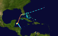
have made landfall at some location at some strength. Most Category 5 hurricanes in the Atlantic make landfall because of their proximity to land in the Caribbean and Gulf of Mexico, where the usual synoptic weather patterns carry them towards land, as opposed to the westward, oceanic mean track of Eastern Pacific hurricanes. Thirteen of the storms made landfall while at Category 5 intensity; 2007 is the only year in which two storms made landfall at this intensity.
Many of these systems made landfall shortly after weakening from a Category 5. This weakening can be caused by dry air near land, shallower waters due to shelving
Continental shelf
The continental shelf is the extended perimeter of each continent and associated coastal plain. Much of the shelf was exposed during glacial periods, but is now submerged under relatively shallow seas and gulfs, and was similarly submerged during other interglacial periods. The continental margin,...
, interaction with land, or cooler waters near shore. In southern Florida, the return period for a Category 5 hurricane is roughly once every 50 years.
The hurricanes are listed in chronological order with their landfalls indicated. Because they never made landfall, Hurricanes Dog
Hurricane Dog (1950)
Hurricane Dog was the most intense hurricane in the 1950 Atlantic hurricane season. The fourth named storm of the season, Dog developed on August 30 to the east of Antigua; after passing through the northern Lesser Antilles, it turned to the north and intensified into a Category 5 hurricane...
, Easy, and Cleo are not included. Hurricane Dog
Hurricane Dog (1950)
Hurricane Dog was the most intense hurricane in the 1950 Atlantic hurricane season. The fourth named storm of the season, Dog developed on August 30 to the east of Antigua; after passing through the northern Lesser Antilles, it turned to the north and intensified into a Category 5 hurricane...
is the only Category 5 hurricane that didn't make landfalls but still caused deaths and damages.
The following table is based on the intensity at landfall
Landfall (meteorology)
Landfall is the event of a tropical cyclone or a waterspout coming onto land after being over water. When a waterspout makes landfall it is reclassified as a tornado, which can then cause damage inland...
, separated by category on the Saffir–Simpson Hurricane Scale.
| Name | Year | Category 5 | Category 4 | Category 3 | Category 2 | Category 1 | Tropical Storm |
|---|---|---|---|---|---|---|---|
| 1924 | Cuba Cuba The Republic of Cuba is an island nation in the Caribbean. The nation of Cuba consists of the main island of Cuba, the Isla de la Juventud, and several archipelagos. Havana is the largest city in Cuba and the country's capital. Santiago de Cuba is the second largest city... |
Florida Florida Florida is a state in the southeastern United States, located on the nation's Atlantic and Gulf coasts. It is bordered to the west by the Gulf of Mexico, to the north by Alabama and Georgia and to the east by the Atlantic Ocean. With a population of 18,801,310 as measured by the 2010 census, it... |
Bahamas | ||||
| 1928 | Puerto Rico Puerto Rico Puerto Rico , officially the Commonwealth of Puerto Rico , is an unincorporated territory of the United States, located in the northeastern Caribbean, east of the Dominican Republic and west of both the United States Virgin Islands and the British Virgin Islands.Puerto Rico comprises an... |
Bahamas & Florida Florida Florida is a state in the southeastern United States, located on the nation's Atlantic and Gulf coasts. It is bordered to the west by the Gulf of Mexico, to the north by Alabama and Georgia and to the east by the Atlantic Ocean. With a population of 18,801,310 as measured by the 2010 census, it... |
|||||
| 1932 | The Bahamas The Bahamas The Bahamas , officially the Commonwealth of the Bahamas, is a nation consisting of 29 islands, 661 cays, and 2,387 islets . It is located in the Atlantic Ocean north of Cuba and Hispaniola , northwest of the Turks and Caicos Islands, and southeast of the United States... |
||||||
| 1935 | Florida Keys Florida Keys The Florida Keys are a coral archipelago in southeast United States. They begin at the southeastern tip of the Florida peninsula, about south of Miami, and extend in a gentle arc south-southwest and then westward to Key West, the westernmost of the inhabited islands, and on to the uninhabited Dry... |
Northwest Florida Big Bend (Florida) The Big Bend of Florida, U.S.A., is an informal region of the state with no official surveyed boundary. It includes part of the counties of the Florida Panhandle. Geologists prefer to characterize Florida’s Big Bend as the drowned karst section of the coast that occurs between the mouth of the... |
The Bahamas The Bahamas The Bahamas , officially the Commonwealth of the Bahamas, is a nation consisting of 29 islands, 661 cays, and 2,387 islets . It is located in the Atlantic Ocean north of Cuba and Hispaniola , northwest of the Turks and Caicos Islands, and southeast of the United States... |
||||
| 1938 | New York New York New York is a state in the Northeastern region of the United States. It is the nation's third most populous state. New York is bordered by New Jersey and Pennsylvania to the south, and by Connecticut, Massachusetts and Vermont to the east... & Connecticut Connecticut Connecticut is a state in the New England region of the northeastern United States. It is bordered by Rhode Island to the east, Massachusetts to the north, and the state of New York to the west and the south .Connecticut is named for the Connecticut River, the major U.S. river that approximately... |
||||||
| 1947 | The Bahamas The Bahamas The Bahamas , officially the Commonwealth of the Bahamas, is a nation consisting of 29 islands, 661 cays, and 2,387 islets . It is located in the Atlantic Ocean north of Cuba and Hispaniola , northwest of the Turks and Caicos Islands, and southeast of the United States... |
Florida Florida Florida is a state in the southeastern United States, located on the nation's Atlantic and Gulf coasts. It is bordered to the west by the Gulf of Mexico, to the north by Alabama and Georgia and to the east by the Atlantic Ocean. With a population of 18,801,310 as measured by the 2010 census, it... |
Louisiana Louisiana Louisiana is a state located in the southern region of the United States of America. Its capital is Baton Rouge and largest city is New Orleans. Louisiana is the only state in the U.S. with political subdivisions termed parishes, which are local governments equivalent to counties... |
||||
| Janet Hurricane Janet Hurricane Janet was the most powerful hurricane of the 1955 Atlantic hurricane season and one of the strongest Atlantic hurricanes on record. It made landfall as a Category 5 hurricane on the Saffir-Simpson Hurricane Scale, causing catastrophic damage and at least 687 deaths in the Lesser... |
1955 | Yucatán Peninsula Yucatán Peninsula The Yucatán Peninsula, in southeastern Mexico, separates the Caribbean Sea from the Gulf of Mexico, with the northern coastline on the Yucatán Channel... |
Mainland Mexico Mexico The United Mexican States , commonly known as Mexico , is a federal constitutional republic in North America. It is bordered on the north by the United States; on the south and west by the Pacific Ocean; on the southeast by Guatemala, Belize, and the Caribbean Sea; and on the east by the Gulf of... |
||||
| Donna Hurricane Donna Hurricane Donna in the 1960 Atlantic hurricane season was a Cape Verde-type hurricane which moved across the Leeward Islands, Puerto Rico, Hispanola, Cuba, The Bahamas, and every state on the East Coast of the United States... |
1960 | Bahamas & Florida Florida Florida is a state in the southeastern United States, located on the nation's Atlantic and Gulf coasts. It is bordered to the west by the Gulf of Mexico, to the north by Alabama and Georgia and to the east by the Atlantic Ocean. With a population of 18,801,310 as measured by the 2010 census, it... |
North Carolina North Carolina North Carolina is a state located in the southeastern United States. The state borders South Carolina and Georgia to the south, Tennessee to the west and Virginia to the north. North Carolina contains 100 counties. Its capital is Raleigh, and its largest city is Charlotte... , New York New York New York is a state in the Northeastern region of the United States. It is the nation's third most populous state. New York is bordered by New Jersey and Pennsylvania to the south, and by Connecticut, Massachusetts and Vermont to the east... & Connecticut Connecticut Connecticut is a state in the New England region of the northeastern United States. It is bordered by Rhode Island to the east, Massachusetts to the north, and the state of New York to the west and the south .Connecticut is named for the Connecticut River, the major U.S. river that approximately... |
||||
| Ethel | 1960 | Mississippi Mississippi Mississippi is a U.S. state located in the Southern United States. Jackson is the state capital and largest city. The name of the state derives from the Mississippi River, which flows along its western boundary, whose name comes from the Ojibwe word misi-ziibi... |
|||||
| Carla Hurricane Carla Hurricane Carla was one of two Category 5 tropical cyclones during the 1961 Atlantic hurricane season. It struck the Texas coast as a Category 4 hurricane, becoming one of the most powerful storms to ever strike the United States. Hurricane Carla was the second most intense storm to ever... |
1961 | Texas Texas Texas is the second largest U.S. state by both area and population, and the largest state by area in the contiguous United States.The name, based on the Caddo word "Tejas" meaning "friends" or "allies", was applied by the Spanish to the Caddo themselves and to the region of their settlement in... |
|||||
| Hattie Hurricane Hattie Hurricane Hattie was the deadliest tropical cyclone of the 1961 Atlantic hurricane season, as well as the strongest, reaching a peak intensity equivalent to Category 5 hurricane intensity... |
1961 | Belize Belize Belize is a constitutional monarchy and the northernmost country in Central America. Belize has a diverse society, comprising many cultures and languages. Even though Kriol and Spanish are spoken among the population, Belize is the only country in Central America where English is the official... |
Mexico Mexico The United Mexican States , commonly known as Mexico , is a federal constitutional republic in North America. It is bordered on the north by the United States; on the south and west by the Pacific Ocean; on the southeast by Guatemala, Belize, and the Caribbean Sea; and on the east by the Gulf of... |
||||
| Beulah Hurricane Beulah Hurricane Beulah was the second tropical storm, second hurricane, and only major hurricane during the 1967 Atlantic hurricane season. It tracked through the Caribbean, struck the Yucatán peninsula of Mexico as a major hurricane, and moved west-northwest into the Gulf of Mexico, briefly gaining... |
1967 | Texas Texas Texas is the second largest U.S. state by both area and population, and the largest state by area in the contiguous United States.The name, based on the Caddo word "Tejas" meaning "friends" or "allies", was applied by the Spanish to the Caddo themselves and to the region of their settlement in... |
Yucatán Peninsula Yucatán Peninsula The Yucatán Peninsula, in southeastern Mexico, separates the Caribbean Sea from the Gulf of Mexico, with the northern coastline on the Yucatán Channel... |
||||
| Camille Hurricane Camille Hurricane Camille was the third and strongest tropical cyclone and second hurricane during the 1969 Atlantic hurricane season. The second of three catastrophic Category 5 hurricanes to make landfall in the United States during the 20th century , which it did near the mouth of the Mississippi River... |
1969 | Mississippi Mississippi Mississippi is a U.S. state located in the Southern United States. Jackson is the state capital and largest city. The name of the state derives from the Mississippi River, which flows along its western boundary, whose name comes from the Ojibwe word misi-ziibi... |
Cuba Cuba The Republic of Cuba is an island nation in the Caribbean. The nation of Cuba consists of the main island of Cuba, the Isla de la Juventud, and several archipelagos. Havana is the largest city in Cuba and the country's capital. Santiago de Cuba is the second largest city... |
||||
| Edith | 1971 | Nicaragua Nicaragua Nicaragua is the largest country in the Central American American isthmus, bordered by Honduras to the north and Costa Rica to the south. The country is situated between 11 and 14 degrees north of the Equator in the Northern Hemisphere, which places it entirely within the tropics. The Pacific Ocean... |
Louisiana Louisiana Louisiana is a state located in the southern region of the United States of America. Its capital is Baton Rouge and largest city is New Orleans. Louisiana is the only state in the U.S. with political subdivisions termed parishes, which are local governments equivalent to counties... |
Belize Belize Belize is a constitutional monarchy and the northernmost country in Central America. Belize has a diverse society, comprising many cultures and languages. Even though Kriol and Spanish are spoken among the population, Belize is the only country in Central America where English is the official... & Mexico Mexico The United Mexican States , commonly known as Mexico , is a federal constitutional republic in North America. It is bordered on the north by the United States; on the south and west by the Pacific Ocean; on the southeast by Guatemala, Belize, and the Caribbean Sea; and on the east by the Gulf of... |
|||
| Anita Hurricane Anita Hurricane Anita was a powerful Atlantic hurricane during an otherwise quiet 1977 Atlantic hurricane season. The first tropical cyclone of the season, Anita developed from a tropical wave on August 29 in the north-central Gulf of Mexico. It tracked westward into an area with conditions favorable for... |
1977 | Mexico Mexico The United Mexican States , commonly known as Mexico , is a federal constitutional republic in North America. It is bordered on the north by the United States; on the south and west by the Pacific Ocean; on the southeast by Guatemala, Belize, and the Caribbean Sea; and on the east by the Gulf of... |
|||||
| David Hurricane David Hurricane David was the fourth named tropical cyclone, second hurricane, and first major hurricane of the 1979 Atlantic hurricane season. A Category 5 hurricane on the Saffir-Simpson Hurricane Scale, David was among the deadliest hurricanes in the latter half of the 20th century, killing... |
1979 | Dominican Republic Dominican Republic The Dominican Republic is a nation on the island of La Hispaniola, part of the Greater Antilles archipelago in the Caribbean region. The western third of the island is occupied by the nation of Haiti, making Hispaniola one of two Caribbean islands that are shared by two countries... |
Dominica Dominica Dominica , officially the Commonwealth of Dominica, is an island nation in the Lesser Antilles region of the Caribbean Sea, south-southeast of Guadeloupe and northwest of Martinique. Its size is and the highest point in the country is Morne Diablotins, which has an elevation of . The Commonwealth... |
Florida Florida Florida is a state in the southeastern United States, located on the nation's Atlantic and Gulf coasts. It is bordered to the west by the Gulf of Mexico, to the north by Alabama and Georgia and to the east by the Atlantic Ocean. With a population of 18,801,310 as measured by the 2010 census, it... |
Cuba Cuba The Republic of Cuba is an island nation in the Caribbean. The nation of Cuba consists of the main island of Cuba, the Isla de la Juventud, and several archipelagos. Havana is the largest city in Cuba and the country's capital. Santiago de Cuba is the second largest city... , Bahamas & Georgia Georgia (U.S. state) Georgia is a state located in the southeastern United States. It was established in 1732, the last of the original Thirteen Colonies. The state is named after King George II of Great Britain. Georgia was the fourth state to ratify the United States Constitution, on January 2, 1788... |
||
| Allen Hurricane Allen Hurricane Allen was the first and strongest hurricane of the 1980 Atlantic hurricane season. It was one of the strongest hurricanes in recorded history, one of the few hurricanes to reach Category 5 status on the Saffir-Simpson Hurricane Scale on three separate occasions, and spent more time... |
1980 | Texas Texas Texas is the second largest U.S. state by both area and population, and the largest state by area in the contiguous United States.The name, based on the Caddo word "Tejas" meaning "friends" or "allies", was applied by the Spanish to the Caddo themselves and to the region of their settlement in... |
|||||
| Gilbert Hurricane Gilbert Hurricane Gilbert was an extremely powerful Cape Verde-type hurricane that formed during the 1988 Atlantic hurricane season and created widespread destruction in the Caribbean Sea and the Gulf of Mexico. It is the second most intense hurricane ever observed in the Atlantic basin behind only... |
1988 | Mexico Mexico The United Mexican States , commonly known as Mexico , is a federal constitutional republic in North America. It is bordered on the north by the United States; on the south and west by the Pacific Ocean; on the southeast by Guatemala, Belize, and the Caribbean Sea; and on the east by the Gulf of... |
Jamaica Jamaica Jamaica is an island nation of the Greater Antilles, in length, up to in width and 10,990 square kilometres in area. It is situated in the Caribbean Sea, about south of Cuba, and west of Hispaniola, the island harbouring the nation-states Haiti and the Dominican Republic... |
Mexico Mexico The United Mexican States , commonly known as Mexico , is a federal constitutional republic in North America. It is bordered on the north by the United States; on the south and west by the Pacific Ocean; on the southeast by Guatemala, Belize, and the Caribbean Sea; and on the east by the Gulf of... |
|||
| Hugo Hurricane Hugo Hurricane Hugo was a classical, destructive and rare Cape Verde-type hurricane which struck the Caribbean islands of Guadeloupe, Montserrat, St. Croix, Puerto Rico and the USA mainland in South Carolina as a Category 4 hurricane during September of the 1989 Atlantic hurricane season... |
1989 | Guadeloupe Guadeloupe Guadeloupe is an archipelago located in the Leeward Islands, in the Lesser Antilles, with a land area of 1,628 square kilometres and a population of 400,000. It is the first overseas region of France, consisting of a single overseas department. As with the other overseas departments, Guadeloupe... , Saint Croix, and South Carolina South Carolina South Carolina is a state in the Deep South of the United States that borders Georgia to the south, North Carolina to the north, and the Atlantic Ocean to the east. Originally part of the Province of Carolina, the Province of South Carolina was one of the 13 colonies that declared independence... |
Puerto Rico Puerto Rico Puerto Rico , officially the Commonwealth of Puerto Rico , is an unincorporated territory of the United States, located in the northeastern Caribbean, east of the Dominican Republic and west of both the United States Virgin Islands and the British Virgin Islands.Puerto Rico comprises an... |
||||
| Andrew Hurricane Andrew Hurricane Andrew was the third Category 5 hurricane to make landfall in the United States, after the Labor Day Hurricane of 1935 and Hurricane Camille in 1969. Andrew was the first named storm and only major hurricane of the otherwise inactive 1992 Atlantic hurricane season... |
1992 | Eleuthera Eleuthera Eleuthera is an island in The Bahamas, lying 50 miles east of Nassau. It is very long and thin—110 miles long and in places little more than a mile wide. According to the 2000 Census, the population of Eleuthera is approximately 8,000... and Florida Florida Florida is a state in the southeastern United States, located on the nation's Atlantic and Gulf coasts. It is bordered to the west by the Gulf of Mexico, to the north by Alabama and Georgia and to the east by the Atlantic Ocean. With a population of 18,801,310 as measured by the 2010 census, it... |
Berry Islands Berry Islands The Berry Islands are a chain of islands and a district of the Bahamas, covering about thirty square miles of the north western part of the Out Islands... |
Louisiana Louisiana Louisiana is a state located in the southern region of the United States of America. Its capital is Baton Rouge and largest city is New Orleans. Louisiana is the only state in the U.S. with political subdivisions termed parishes, which are local governments equivalent to counties... |
|||
| Mitch Hurricane Mitch Hurricane Mitch was the most powerful hurricane and the most destructive of the 1998 Atlantic hurricane season, with maximum sustained winds of 180 mph . The storm was the thirteenth tropical storm, ninth hurricane, and third major hurricane of the season. Along with Hurricane Georges, Mitch... |
1998 | Honduras Honduras Honduras is a republic in Central America. It was previously known as Spanish Honduras to differentiate it from British Honduras, which became the modern-day state of Belize... |
Mexico Mexico The United Mexican States , commonly known as Mexico , is a federal constitutional republic in North America. It is bordered on the north by the United States; on the south and west by the Pacific Ocean; on the southeast by Guatemala, Belize, and the Caribbean Sea; and on the east by the Gulf of... & Florida Florida Florida is a state in the southeastern United States, located on the nation's Atlantic and Gulf coasts. It is bordered to the west by the Gulf of Mexico, to the north by Alabama and Georgia and to the east by the Atlantic Ocean. With a population of 18,801,310 as measured by the 2010 census, it... |
||||
| Isabel Hurricane Isabel Hurricane Isabel was the costliest and deadliest hurricane in the 2003 Atlantic hurricane season. The ninth named storm, fifth hurricane, and second major hurricane of the season, Isabel formed near the Cape Verde Islands from a tropical wave on September 6 in the tropical Atlantic Ocean... |
2003 | North Carolina North Carolina North Carolina is a state located in the southeastern United States. The state borders South Carolina and Georgia to the south, Tennessee to the west and Virginia to the north. North Carolina contains 100 counties. Its capital is Raleigh, and its largest city is Charlotte... |
|||||
| Ivan Hurricane Ivan Hurricane Ivan was a large, long-lived, Cape Verde-type hurricane that caused widespread damage in the Caribbean and United States. The cyclone was the ninth named storm, the sixth hurricane and the fourth major hurricane of the active 2004 Atlantic hurricane season... |
2004 | Florida Florida Florida is a state in the southeastern United States, located on the nation's Atlantic and Gulf coasts. It is bordered to the west by the Gulf of Mexico, to the north by Alabama and Georgia and to the east by the Atlantic Ocean. With a population of 18,801,310 as measured by the 2010 census, it... |
Grenada Grenada Grenada is an island country and Commonwealth Realm consisting of the island of Grenada and six smaller islands at the southern end of the Grenadines in the southeastern Caribbean Sea... & Alabama Alabama Alabama is a state located in the southeastern region of the United States. It is bordered by Tennessee to the north, Georgia to the east, Florida and the Gulf of Mexico to the south, and Mississippi to the west. Alabama ranks 30th in total land area and ranks second in the size of its inland... |
||||
| Emily Hurricane Emily (2005) Hurricane Emily was a powerful, early season tropical cyclone that caused significant damage across the Caribbean Sea to Mexico. A Cape Verde-type hurricane, the storm formed on July 10, 2005, in the central Atlantic Ocean before passing through the Windward Islands on July 14... |
2005 | Mexico Mexico The United Mexican States , commonly known as Mexico , is a federal constitutional republic in North America. It is bordered on the north by the United States; on the south and west by the Pacific Ocean; on the southeast by Guatemala, Belize, and the Caribbean Sea; and on the east by the Gulf of... (twice) |
Mexico Mexico The United Mexican States , commonly known as Mexico , is a federal constitutional republic in North America. It is bordered on the north by the United States; on the south and west by the Pacific Ocean; on the southeast by Guatemala, Belize, and the Caribbean Sea; and on the east by the Gulf of... |
Grenada Grenada Grenada is an island country and Commonwealth Realm consisting of the island of Grenada and six smaller islands at the southern end of the Grenadines in the southeastern Caribbean Sea... |
|||
| Katrina Hurricane Katrina Hurricane Katrina of the 2005 Atlantic hurricane season was a powerful Atlantic hurricane. It is the costliest natural disaster, as well as one of the five deadliest hurricanes, in the history of the United States. Among recorded Atlantic hurricanes, it was the sixth strongest overall... |
2005 | Louisiana Louisiana Louisiana is a state located in the southern region of the United States of America. Its capital is Baton Rouge and largest city is New Orleans. Louisiana is the only state in the U.S. with political subdivisions termed parishes, which are local governments equivalent to counties... & Mississippi Mississippi Mississippi is a U.S. state located in the Southern United States. Jackson is the state capital and largest city. The name of the state derives from the Mississippi River, which flows along its western boundary, whose name comes from the Ojibwe word misi-ziibi... |
Florida Florida Florida is a state in the southeastern United States, located on the nation's Atlantic and Gulf coasts. It is bordered to the west by the Gulf of Mexico, to the north by Alabama and Georgia and to the east by the Atlantic Ocean. With a population of 18,801,310 as measured by the 2010 census, it... |
||||
| Rita Hurricane Rita Hurricane Rita was the fourth-most intense Atlantic hurricane ever recorded and the most intense tropical cyclone ever observed in the Gulf of Mexico. Rita caused $11.3 billion in damage on the U.S. Gulf Coast in September 2005... |
2005 | Louisiana Louisiana Louisiana is a state located in the southern region of the United States of America. Its capital is Baton Rouge and largest city is New Orleans. Louisiana is the only state in the U.S. with political subdivisions termed parishes, which are local governments equivalent to counties... |
|||||
| Wilma Hurricane Wilma Hurricane Wilma was the most intense tropical cyclone ever recorded in the Atlantic basin. Wilma was the twenty-second storm , thirteenth hurricane, sixth major hurricane, and fourth Category 5 hurricane of the record-breaking 2005 season... |
2005 | Mexico Mexico The United Mexican States , commonly known as Mexico , is a federal constitutional republic in North America. It is bordered on the north by the United States; on the south and west by the Pacific Ocean; on the southeast by Guatemala, Belize, and the Caribbean Sea; and on the east by the Gulf of... (twice) |
Florida Florida Florida is a state in the southeastern United States, located on the nation's Atlantic and Gulf coasts. It is bordered to the west by the Gulf of Mexico, to the north by Alabama and Georgia and to the east by the Atlantic Ocean. With a population of 18,801,310 as measured by the 2010 census, it... |
||||
| Dean | 2007 | Yucatán Peninsula Yucatán Peninsula The Yucatán Peninsula, in southeastern Mexico, separates the Caribbean Sea from the Gulf of Mexico, with the northern coastline on the Yucatán Channel... |
Veracruz Veracruz Veracruz, formally Veracruz de Ignacio de la Llave officially Estado Libre y Soberano de Veracruz de Ignacio de la Llave , is one of the 31 states that, along with the Federal District, comprise the 32 federative entities of Mexico. It is divided in 212 municipalities and its capital city is... |
||||
| Felix | 2007 | Nicaragua Nicaragua Nicaragua is the largest country in the Central American American isthmus, bordered by Honduras to the north and Costa Rica to the south. The country is situated between 11 and 14 degrees north of the Equator in the Northern Hemisphere, which places it entirely within the tropics. The Pacific Ocean... |
Grenada Grenada Grenada is an island country and Commonwealth Realm consisting of the island of Grenada and six smaller islands at the southern end of the Grenadines in the southeastern Caribbean Sea... |
See also
- List of Atlantic hurricanes
- List of Atlantic hurricane seasons
- List of Category 4 Atlantic hurricanes
- List of Category 5 Pacific hurricanes