
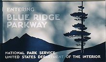
Blue Ridge Parkway
Encyclopedia
National parkway
National Parkway is a designation for a protected area in the United States. The designation is given to a scenic roadway and a protected corridor of surrounding parkland. National Parkways often connect cultural or historic sites.-See also:...
and All-American Road
National Scenic Byway
A National Scenic Byway is a road recognized by the United States Department of Transportation for its archeological, cultural, historic, natural, recreational, and/or scenic qualities. The program was established by Congress in 1991 to preserve and protect the nation's scenic but often...
in the United States
United States
The United States of America is a federal constitutional republic comprising fifty states and a federal district...
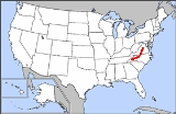
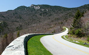
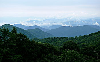
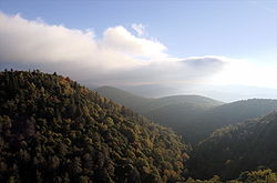
, noted for its scenic beauty. It runs for 469 miles (755 km), mostly along the famous Blue Ridge
Blue Ridge Mountains
The Blue Ridge Mountains are a physiographic province of the larger Appalachian Mountains range. This province consists of northern and southern physiographic regions, which divide near the Roanoke River gap. The mountain range is located in the eastern United States, starting at its southern-most...
, a major mountain chain that is part of the Appalachian Mountains
Appalachian Mountains
The Appalachian Mountains #Whether the stressed vowel is or ,#Whether the "ch" is pronounced as a fricative or an affricate , and#Whether the final vowel is the monophthong or the diphthong .), often called the Appalachians, are a system of mountains in eastern North America. The Appalachians...
. Its southern terminus is on the boundary between Great Smoky Mountains National Park
Great Smoky Mountains National Park
Great Smoky Mountains National Park is a United States National Park and UNESCO World Heritage Site that straddles the ridgeline of the Great Smoky Mountains, part of the Blue Ridge Mountains, which are a division of the larger Appalachian Mountain chain. The border between Tennessee and North...
and the Cherokee Indian Reservation
Qualla Boundary
The Qualla Boundary is the territory where the Eastern Band of Cherokee Indians reside in western North Carolina.-Location:...
in North Carolina
North Carolina
North Carolina is a state located in the southeastern United States. The state borders South Carolina and Georgia to the south, Tennessee to the west and Virginia to the north. North Carolina contains 100 counties. Its capital is Raleigh, and its largest city is Charlotte...
, from which it travels north to Shenandoah National Park
Shenandoah National Park
Shenandoah National Park encompasses part of the Blue Ridge Mountains in the U.S. state of Virginia. This national park is long and narrow, with the broad Shenandoah River and valley on the west side, and the rolling hills of the Virginia Piedmont on the east...
in Virginia
Virginia
The Commonwealth of Virginia , is a U.S. state on the Atlantic Coast of the Southern United States. Virginia is nicknamed the "Old Dominion" and sometimes the "Mother of Presidents" after the eight U.S. presidents born there...
and offers access to the Skyline Drive
Skyline Drive
Skyline Drive is a 105-mile road that runs the entire length of the National Park Service's Shenandoah National Park in the Blue Ridge Mountains of Virginia, generally along the ridge of the mountains. The scenic drive is particularly popular in the fall when the leaves are changing colors...
, the major north/south artery through the Park. The two All-American Byways are separate and distinct. The Blue Ridge Parkway was built to connect Shenandoah National Park to the Great Smoky Mountains National Park.
The Parkway is not a National Park, but is a National Scenic Byway and All-American Road, and is the most visited unit in the United States National Park System. Land on either side of the road
Road
A road is a thoroughfare, route, or way on land between two places, which typically has been paved or otherwise improved to allow travel by some conveyance, including a horse, cart, or motor vehicle. Roads consist of one, or sometimes two, roadways each with one or more lanes and also any...
is maintained by the National Park Service
National Park Service
The National Park Service is the U.S. federal agency that manages all national parks, many national monuments, and other conservation and historical properties with various title designations...
and, in many places, the park is bordered by land protected by the United States Forest Service
United States Forest Service
The United States Forest Service is an agency of the United States Department of Agriculture that administers the nation's 155 national forests and 20 national grasslands, which encompass...
. The Parkway will be depicted on North Carolina's version of the America the Beautiful quarter in 2015.
History
Begun during the administration of U.S. president Franklin D. Roosevelt, the project was originally called the Appalachian Scenic Highway. Most construction was carried out by private contractors under federal contracts under an authorization by Harold L. IckesHarold L. Ickes
Harold LeClair Ickes was a United States administrator and politician. He served as United States Secretary of the Interior for 13 years, from 1933 to 1946, the longest tenure of anyone to hold the office, and the second longest serving Cabinet member in U.S. history next to James Wilson. Ickes...
in his role as federal public works administrator. Work began on September 11, 1935, near Cumberland Knob in North Carolina
North Carolina
North Carolina is a state located in the southeastern United States. The state borders South Carolina and Georgia to the south, Tennessee to the west and Virginia to the north. North Carolina contains 100 counties. Its capital is Raleigh, and its largest city is Charlotte...
; construction in Virginia began the following February. On June 30, 1936, Congress formally authorized the project as the Blue Ridge Parkway and placed it under the jurisdiction of the National Park Service. Some work was carried out by various New Deal
New Deal
The New Deal was a series of economic programs implemented in the United States between 1933 and 1936. They were passed by the U.S. Congress during the first term of President Franklin D. Roosevelt. The programs were Roosevelt's responses to the Great Depression, and focused on what historians call...
public works agencies. The Works Progress Administration
Works Progress Administration
The Works Progress Administration was the largest and most ambitious New Deal agency, employing millions of unskilled workers to carry out public works projects, including the construction of public buildings and roads, and operated large arts, drama, media, and literacy projects...
did some roadway construction. Crews from the Emergency Relief Administration carried out landscape work and development of parkway recreation areas. Personnel from four Civilian Conservation Corps
Civilian Conservation Corps
The Civilian Conservation Corps was a public work relief program that operated from 1933 to 1942 in the United States for unemployed, unmarried men from relief families, ages 18–25. A part of the New Deal of President Franklin D...
camps worked on roadside cleanup, roadside plantings, grading slopes, and improving adjacent fields and forest lands. During World War II
World War II
World War II, or the Second World War , was a global conflict lasting from 1939 to 1945, involving most of the world's nations—including all of the great powers—eventually forming two opposing military alliances: the Allies and the Axis...
, the CCC crews were replaced by conscientious objectors in the Civilian Public Service
Civilian Public Service
The Civilian Public Service provided conscientious objectors in the United States an alternative to military service during World War II...
program.
Construction of the parkway took over 52 years to complete, the last stretch (near the Linn Cove Viaduct
Linn Cove Viaduct
Linn Cove Viaduct is a 1243-foot concrete segmental bridge which snakes around the slopes of Grandfather Mountain in North Carolina. It was completed in 1983 at a cost of $10 million and was the last section of the Blue Ridge Parkway to be finished...
) being laid around Grandfather Mountain
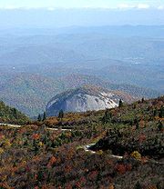
Grandfather Mountain
Grandfather Mountain is a mountain, a non-profit attraction, and a North Carolina state parknear Linville, North Carolina. At 5,946 feet , it is the highest peak on the eastern escarpment of the Blue Ridge Mountains, one of the major chains of the Appalachian Mountains. The Blue Ridge Parkway...
in 1987. The Blue Ridge Parkway tunnels
Blue Ridge Parkway tunnels
Blue Ridge Parkway tunnels consist of a total of 26 vehicle tunnels constructed along the of the Blue Ridge Parkway. One, the Bluff Mountain Tunnel, is in Virginia and twenty-five are in North Carolina....
were constructed through the rock—one in Virginia
Virginia
The Commonwealth of Virginia , is a U.S. state on the Atlantic Coast of the Southern United States. Virginia is nicknamed the "Old Dominion" and sometimes the "Mother of Presidents" after the eight U.S. presidents born there...
and twenty-five in North Carolina
North Carolina
North Carolina is a state located in the southeastern United States. The state borders South Carolina and Georgia to the south, Tennessee to the west and Virginia to the north. North Carolina contains 100 counties. Its capital is Raleigh, and its largest city is Charlotte...
. Sections of the parkway near the tunnels are often closed in winter. (Due to dripping groundwater
Groundwater
Groundwater is water located beneath the ground surface in soil pore spaces and in the fractures of rock formations. A unit of rock or an unconsolidated deposit is called an aquifer when it can yield a usable quantity of water. The depth at which soil pore spaces or fractures and voids in rock...
from above, freezing temperatures, and the lack of sunlight, ice often accumulates inside these areas even when the surrounding areas are above freezing.) The highest point on the parkway (south of Waynesville
Waynesville, North Carolina
Waynesville is a town in and the county seat of Haywood County, North Carolina, United States. It is the largest town in Haywood County and the largest in Western North Carolina west of Asheville. Waynesville is located about or 50 km southwest of Asheville between the Great Smoky and Blue...
, near Mount Pisgah
Mount Pisgah (North Carolina)
Mount Pisgah is a mountain in the Appalachian Mountain Range and part of the Blue Ridge Mountains of North Carolina, United States. The mountain's height is 5,721 feet and it sits approximately 15 miles southwest of Asheville near the crossing of the boundaries of Buncombe, Haywood, Henderson...
in North Carolina
North Carolina
North Carolina is a state located in the southeastern United States. The state borders South Carolina and Georgia to the south, Tennessee to the west and Virginia to the north. North Carolina contains 100 counties. Its capital is Raleigh, and its largest city is Charlotte...
) is 6053 feet or 1845 m above sea level (AMSL) on Richland Balsam Mountain at Milepost 431, and is often closed from November to April due to inclement weather such as snow, fog, and even freezing fog from low clouds. The parkway is carried across streams, railway ravines and cross roads by 168 bridges and six viaducts.
The parkway runs from the southern terminus of Shenandoah National Park
Shenandoah National Park
Shenandoah National Park encompasses part of the Blue Ridge Mountains in the U.S. state of Virginia. This national park is long and narrow, with the broad Shenandoah River and valley on the west side, and the rolling hills of the Virginia Piedmont on the east...
's Skyline Drive
Skyline Drive
Skyline Drive is a 105-mile road that runs the entire length of the National Park Service's Shenandoah National Park in the Blue Ridge Mountains of Virginia, generally along the ridge of the mountains. The scenic drive is particularly popular in the fall when the leaves are changing colors...
in Virginia at Rockfish Gap
Rockfish Gap
Rockfish Gap is a wind gap located in the Blue Ridge Mountains between Charlottesville and Waynesboro, Virginia, United States, through Afton Mountain, which is frequently used to refer to the gap....
to U.S. Route 441
U.S. Route 441
U.S. Route 441 is a spur route of U.S. Route 41. It currently runs for 939 miles from U.S. Route 41 in Miami, Florida to U.S. Route 25W in Lake City, Tennessee. Between its termini, US 441 passes through the states of Florida, Georgia, North Carolina, and Tennessee...
at Oconaluftee
Oconaluftee (Great Smoky Mountains)
Oconaluftee is the name of a river valley in the Great Smoky Mountains of North Carolina, located in the Southeastern United States. Formerly the site of a Cherokee village and Appalachian community, the valley's bottomland is now home to the main entrance to the North Carolina section of the...
in the Great Smoky Mountains National Park
Great Smoky Mountains National Park
Great Smoky Mountains National Park is a United States National Park and UNESCO World Heritage Site that straddles the ridgeline of the Great Smoky Mountains, part of the Blue Ridge Mountains, which are a division of the larger Appalachian Mountain chain. The border between Tennessee and North...
near Cherokee
Cherokee, North Carolina
Cherokee is a town in Swain County, North Carolina, USA, within the Qualla Boundary land trust. It is located in the Oconaluftee River Valley, near the intersection of U.S. Route 19 and U.S...
, North Carolina. There is no fee for using the parkway, however commercial vehicles are prohibited without approval from the Park Service Headquarters, near Asheville, North Carolina
Asheville, North Carolina
Asheville is a city in and the county seat of Buncombe County, North Carolina, United States. It is the largest city in Western North Carolina, and the 11th largest city in North Carolina. The City is home to the United States National Climatic Data Center , which is the world's largest active...
. The roadway is not maintained in the winter, and sections which pass over especially high elevation
Elevation
The elevation of a geographic location is its height above a fixed reference point, most commonly a reference geoid, a mathematical model of the Earth's sea level as an equipotential gravitational surface ....
s and through tunnels are often impassable and therefore closed from late fall through early spring. Weather is extremely variable in the mountains, so conditions and closures often change rapidly. The speed limit is never higher than 45 mph (70 km/h) and lower in some sections.
Waynesboro, Virginia
Waynesboro, deriving its name from General Anthony Wayne, is an independent city surrounded by Augusta County in the U.S. state of Virginia. The population was 21,006 in 2010.....
, Roanoke
Roanoke, Virginia
Roanoke is an independent city in the Mid-Atlantic U.S. state of Virginia and is the tenth-largest city in the Commonwealth. It is located in the Roanoke Valley of the Roanoke Region of Virginia. The population within the city limits was 97,032 as of 2010...
, and Galax
Galax, Virginia
Galax is an independent city in the southwestern part of the Commonwealth of Virginia. It is bounded to the northeast by Carroll County and to the southwest by Grayson County. The population was 7,042 as of 2010...
in Virginia; and in North Carolina, Boone
Boone, North Carolina
Boone is a town located in the Blue Ridge Mountains of western North Carolina, United States. Boone's population was reported as 17,122, as of 2010...
and Asheville
Asheville, North Carolina
Asheville is a city in and the county seat of Buncombe County, North Carolina, United States. It is the largest city in Western North Carolina, and the 11th largest city in North Carolina. The City is home to the United States National Climatic Data Center , which is the world's largest active...
, where it runs across the property of the Biltmore Estate
Biltmore Estate
Biltmore House is a Châteauesque-styled mansion near Asheville, North Carolina, built by George Washington Vanderbilt II between 1889 and 1895. It is the largest privately-owned home in the United States, at and featuring 250 rooms...
. The Blue Ridge Music Center
Blue Ridge Music Center
The Blue Ridge Music Center is part of the Blue Ridge Parkway system and is located at Milepost 213 near Galax, Virginia. The center celebrates the history and performance of old time mountain music of Virginia and North Carolina and is largely concerned with local artists who best show this...
(also part of the park) is located in Galax, and Mount Mitchell
Mount Mitchell (North Carolina)
Mount Mitchell is the highest peak of the Appalachian Mountains and the highest peak in the eastern United States. It was the highest point in any state of the United States until Texas joined the union in 1845. The nearest higher point east of the Rocky Mountains is Harney Peak in the Black Hills...
(the highest point in eastern North America
North America
North America is a continent wholly within the Northern Hemisphere and almost wholly within the Western Hemisphere. It is also considered a northern subcontinent of the Americas...
) is only accessible via a state road from the parkway at milepost 355.4.
Ecology along the parkway
Flowering shrubShrub
A shrub or bush is distinguished from a tree by its multiple stems and shorter height, usually under 5–6 m tall. A large number of plants may become either shrubs or trees, depending on the growing conditions they experience...
s and wildflower
Wildflower
A wildflower is a flower that grows wild, meaning it was not intentionally seeded or planted. Yet "wildflower" meadows of a few mixed species are sold in seed packets. The term "wildflower" has been made vague by commercial seedsmen who are interested in selling more flowers or seeds more...
s dominate the parkway in the spring, including rhododendron
Rhododendron
Rhododendron is a genus of over 1 000 species of woody plants in the heath family, most with showy flowers...
s and dogwood
Dogwood
The genus Cornus is a group of about 30-60 species of woody plants in the family Cornaceae, commonly known as dogwoods. Most dogwoods are deciduous trees or shrubs, but a few species are nearly herbaceous perennial subshrubs, and a few of the woody species are evergreen...
s, moving from valleys to mountains as the cold weather retreats. Smaller annuals
Annual plant
An annual plant is a plant that usually germinates, flowers, and dies in a year or season. True annuals will only live longer than a year if they are prevented from setting seed...
and perennials
Perennial plant
A perennial plant or simply perennial is a plant that lives for more than two years. The term is often used to differentiate a plant from shorter lived annuals and biennials. The term is sometimes misused by commercial gardeners or horticulturalists to describe only herbaceous perennials...
such as the daisy
Asteraceae
The Asteraceae or Compositae , is an exceedingly large and widespread family of vascular plants. The group has more than 22,750 currently accepted species, spread across 1620 genera and 12 subfamilies...
and aster flower through the summer. Brilliant autumn foliage occurs later in September on the mountaintops, descending to the valleys by later in October. Often in early to middle October and middle to late April, all three season
Season
A season is a division of the year, marked by changes in weather, ecology, and hours of daylight.Seasons result from the yearly revolution of the Earth around the Sun and the tilt of the Earth's axis relative to the plane of revolution...
s can be seen simply by looking down from the cold and wind
Wind
Wind is the flow of gases on a large scale. On Earth, wind consists of the bulk movement of air. In outer space, solar wind is the movement of gases or charged particles from the sun through space, while planetary wind is the outgassing of light chemical elements from a planet's atmosphere into space...
y parkway to the green
Green
Green is a color, the perception of which is evoked by light having a spectrum dominated by energy with a wavelength of roughly 520–570 nanometres. In the subtractive color system, it is not a primary color, but is created out of a mixture of yellow and blue, or yellow and cyan; it is considered...
and warm valley
Valley
In geology, a valley or dale is a depression with predominant extent in one direction. A very deep river valley may be called a canyon or gorge.The terms U-shaped and V-shaped are descriptive terms of geography to characterize the form of valleys...
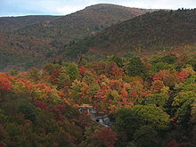
s below. October is especially dramatic, as the color
Color
Color or colour is the visual perceptual property corresponding in humans to the categories called red, green, blue and others. Color derives from the spectrum of light interacting in the eye with the spectral sensitivities of the light receptors...
ed leaves
Leaves
-History:Vocalist Arnar Gudjonsson was formerly the guitarist with Mower, and he was joined by Hallur Hallsson , Arnar Ólafsson , Bjarni Grímsson , and Andri Ásgrímsson . Late in 2001 they played with Emiliana Torrini and drew early praise from the New York Times...
stand out boldly and occur mostly at the same time, unlike the flower
Flower
A flower, sometimes known as a bloom or blossom, is the reproductive structure found in flowering plants . The biological function of a flower is to effect reproduction, usually by providing a mechanism for the union of sperm with eggs...
s.
Major tree
Tree
A tree is a perennial woody plant. It is most often defined as a woody plant that has many secondary branches supported clear of the ground on a single main stem or trunk with clear apical dominance. A minimum height specification at maturity is cited by some authors, varying from 3 m to...
s include oak
Oak
An oak is a tree or shrub in the genus Quercus , of which about 600 species exist. "Oak" may also appear in the names of species in related genera, notably Lithocarpus...
, hickory
Hickory
Trees in the genus Carya are commonly known as hickory, derived from the Powhatan language of Virginia. The genus includes 17–19 species of deciduous trees with pinnately compound leaves and big nuts...
, and tulip tree
Liriodendron
Liriodendron is a genus of two species of characteristically large deciduous trees in the magnolia family .These trees are widely known by the common name tulip tree or tuliptree for their large flowers superficially resembling tulips, but are closely related to magnolias rather than lilies, the...
at lower elevations and buckeye and ash
Ash tree
Fraxinus is a genus flowering plants in the olive and lilac family, Oleaceae. It contains 45-65 species of usually medium to large trees, mostly deciduous though a few subtropical species are evergreen. The tree's common English name, ash, goes back to the Old English æsc, while the generic name...
in the middle, turning into conifers such as fir
Fir
Firs are a genus of 48–55 species of evergreen conifers in the family Pinaceae. They are found through much of North and Central America, Europe, Asia, and North Africa, occurring in mountains over most of the range...
and spruce
Spruce
A spruce is a tree of the genus Picea , a genus of about 35 species of coniferous evergreen trees in the Family Pinaceae, found in the northern temperate and boreal regions of the earth. Spruces are large trees, from tall when mature, and can be distinguished by their whorled branches and conical...
at the highest elevations on the parkway. Trees near ridge
Ridge
A ridge is a geological feature consisting of a chain of mountains or hills that form a continuous elevated crest for some distance. Ridges are usually termed hills or mountains as well, depending on size. There are several main types of ridges:...
s, peaks
Mountain
Image:Himalaya_annotated.jpg|thumb|right|The Himalayan mountain range with Mount Everestrect 58 14 160 49 Chomo Lonzorect 200 28 335 52 Makalurect 378 24 566 45 Mount Everestrect 188 581 920 656 Tibetan Plateaurect 250 406 340 427 Rong River...
, and passes
Mountain pass
A mountain pass is a route through a mountain range or over a ridge. If following the lowest possible route, a pass is locally the highest point on that route...
(often called gaps or notches) are often distorted and even contorted by the wind, and persistent rime ice deposited by passing clouds in the winter.
Parkway highlights
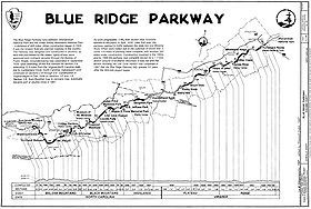
(Much of this information comes from the official Blue Ridge Parkway map GPO:2003-496-196/40572 Reprint 2004)
Highlights in Virginia
- Mile 0 Rockfish GapRockfish GapRockfish Gap is a wind gap located in the Blue Ridge Mountains between Charlottesville and Waynesboro, Virginia, United States, through Afton Mountain, which is frequently used to refer to the gap....
near WaynesboroWaynesboro, VirginiaWaynesboro, deriving its name from General Anthony Wayne, is an independent city surrounded by Augusta County in the U.S. state of Virginia. The population was 21,006 in 2010.....
, VirginiaVirginiaThe Commonwealth of Virginia , is a U.S. state on the Atlantic Coast of the Southern United States. Virginia is nicknamed the "Old Dominion" and sometimes the "Mother of Presidents" after the eight U.S. presidents born there...
, is the northern end of the Blue Ridge Parkway. To the north the parkway connects directly to Skyline DriveSkyline DriveSkyline Drive is a 105-mile road that runs the entire length of the National Park Service's Shenandoah National Park in the Blue Ridge Mountains of Virginia, generally along the ridge of the mountains. The scenic drive is particularly popular in the fall when the leaves are changing colors...
, which winds 105 miles (169 km) through Shenandoah National ParkShenandoah National ParkShenandoah National Park encompasses part of the Blue Ridge Mountains in the U.S. state of Virginia. This national park is long and narrow, with the broad Shenandoah River and valley on the west side, and the rolling hills of the Virginia Piedmont on the east...
. U.S. 250 and I-64Interstate 64Interstate 64 is an Interstate Highway in the Midwestern and Southeastern United States. Its western terminus is at I-70, U.S. 40, and U.S. 61 in Wentzville, Missouri. Its eastern terminus is at an interchange with I-264 and I-664 at Bowers Hill in Chesapeake, Virginia. As I-64 is concurrent with...
take you to CharlottesvilleCharlottesville, VirginiaCharlottesville is an independent city geographically surrounded by but separate from Albemarle County in the Commonwealth of Virginia, United States, and named after Charlotte of Mecklenburg-Strelitz, the queen consort of King George III of the United Kingdom.The official population estimate for...
to the east and StauntonStaunton, VirginiaStaunton is an independent city within the confines of Augusta County in the commonwealth of Virginia. The population was 23,746 as of 2010. It is the county seat of Augusta County....
to the west. - 5 to 9.3 Humpback RockHumpback RockHumpback Rock is a massive greenstone outcrop near the peak of Humpback Mountain with a summit elevation of . The rock is so named for the visual effect of a "hump" it creates on the western face of the mountain...
has a self-guiding trailSelf-guided tourA self-guided tour is a self-governing tour where one navigates a route oneself as opposed to an escorted tour where a tour guide directs the route, times, information, and places toured...
through a collection of old Appalachian farm buildings. A hiking trail from the parking area (at mile 6.1) leads 0.75 miles (1.2 km) to The Rocks, whose humped appearance gives the area its name. Greenstone self-guiding trail (8.8). - 10.7 Ravens Roost offers vistas of Torry Mountain and the Shenandoah ValleyShenandoah ValleyThe Shenandoah Valley is both a geographic valley and cultural region of western Virginia and West Virginia in the United States. The valley is bounded to the east by the Blue Ridge Mountains, to the west by the eastern front of the Ridge-and-Valley Appalachians , to the north by the Potomac River...
to the west. The overlook is built above a cliff, so it is frequently used for rock-climbing and hang-gliding. There is also a single picnic table. - 16 Sherando Lake is a recreation area in George Washington National Forest 4.5 miles (7.2 km) from the parkway via VA.814. Swimming, picnicking, and campingCampingCamping is an outdoor recreational activity. The participants leave urban areas, their home region, or civilization and enjoy nature while spending one or several nights outdoors, usually at a campsite. Camping may involve the use of a tent, caravan, motorhome, cabin, a primitive structure, or no...
. Fees charged. - 29 Whetstone Ridge provided many a mountain man with a fine-grained sharpening stoneSharpening stoneSharpening stones, water stones or whetstones are used to grind and hone the edges of steel tools and implements. Examples of items that may be sharpened with a sharpening stone include scissors, scythes, knives, razors and tools such as chisels, hand scrapers and plane blades...
. - 34.4 Yankee Horse Ridge supposedly is where a hard-riding UnionUnion ArmyThe Union Army was the land force that fought for the Union during the American Civil War. It was also known as the Federal Army, the U.S. Army, the Northern Army and the National Army...
soldierSoldierA soldier is a member of the land component of national armed forces; whereas a soldier hired for service in a foreign army would be termed a mercenary...
's horseHorseThe horse is one of two extant subspecies of Equus ferus, or the wild horse. It is a single-hooved mammal belonging to the taxonomic family Equidae. The horse has evolved over the past 45 to 55 million years from a small multi-toed creature into the large, single-toed animal of today...
fell and had to be shot. See a reconstructed spur of an old loggingLoggingLogging is the cutting, skidding, on-site processing, and loading of trees or logs onto trucks.In forestry, the term logging is sometimes used in a narrow sense concerning the logistics of moving wood from the stump to somewhere outside the forest, usually a sawmill or a lumber yard...
railroad while walking to Wigwam Falls. - 58 to 63.6 Otter Creek runs 10 miles (16.1 km) down the Blue Ridge to the James RiverJames River (Virginia)The James River is a river in the U.S. state of Virginia. It is long, extending to if one includes the Jackson River, the longer of its two source tributaries. The James River drains a catchment comprising . The watershed includes about 4% open water and an area with a population of 2.5 million...
. Otter Lake (63.1), fishingFishingFishing is the activity of trying to catch wild fish. Fish are normally caught in the wild. Techniques for catching fish include hand gathering, spearing, netting, angling and trapping....
, trail. - 63.8 The James River and Kanawha CanalJames River and Kanawha CanalThe James River and Kanawha Canal was a canal in Virginia, which was built to facilitate shipments of passengers and freight by water between the western counties of Virginia and the coast....
is where a footbridgeFootbridgeA footbridge or pedestrian bridge is a bridge designed for pedestrians and in some cases cyclists, animal traffic and horse riders, rather than vehicular traffic. Footbridges complement the landscape and can be used decoratively to visually link two distinct areas or to signal a transaction...
leads across the river to the restored canal locks and exhibits. A self-guiding trail follows the river bluff. - 71 Onion Mountain's short loop trail leads through rhododendronRhododendronRhododendron is a genus of over 1 000 species of woody plants in the heath family, most with showy flowers...
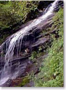
and mountain laurel. - 83.4 Fallingwater Cascades can be seen along a 1.6 miles (2.6 km) loop trail.
- 84 to 87 Peaks of OtterPeaks of OtterThe Peaks of Otter are three mountain peaks in the Blue Ridge Mountains, overlooking the town of Bedford, Virginia, nine miles to the southeast along State Route 43. These peaks are...
's spectacular views have been popular since the days of Thomas JeffersonThomas JeffersonThomas Jefferson was the principal author of the United States Declaration of Independence and the Statute of Virginia for Religious Freedom , the third President of the United States and founder of the University of Virginia...
. A shuttle bus provides service to Sharp Top. Fee Charged. - 114.9 Roanoke River GorgeRoanoke RiverThe Roanoke River is a river in southern Virginia and northeastern North Carolina in the United States, 410 mi long. A major river of the southeastern United States, it drains a largely rural area of the coastal plain from the eastern edge of the Appalachian Mountains southeast across the Piedmont...
opens before you from the overlook, after a 10-minute walk. - 120.4 Roanoke MountainRoanoke MountainRoanoke Mountain is a mountain in Virginia. It is located two miles south of the Roanoke River and one mile east of the Blue Ridge Parkway.The summit of Roanoke Mountain may be reached by a one-way loop road which branches off the Blue Ridge Parkway. There are two overlooks on the summit ridge...
is a 3.7 miles (6 km) side trip. The one-way loop road takes you over the mountain for impressive views. Steep grades; towed vehicles prohibited. - 129.6 Roanoke ValleyRoanoke, VirginiaRoanoke is an independent city in the Mid-Atlantic U.S. state of Virginia and is the tenth-largest city in the Commonwealth. It is located in the Roanoke Valley of the Roanoke Region of Virginia. The population within the city limits was 97,032 as of 2010...
Overlook gives a view of the largest community along the parkway. Reach the city via U.S. Route 220 (at milepost 121), State Route 24Virginia State Route 24Virginia State Route 24 is a primary state highway in the U.S. state of Virginia. The state highway runs from U.S. Route 221 and SR 116 in Roanoke east to US 60 in Mt. Rush. SR 24 connects Roanoke with several small communities in southern Bedford County and central Campbell County...
(at 112), and U.S. Route 460U.S. Route 460 in VirginiaU.S. Route 460 in Virginia runs east–west through the southern part of the state. It has two separate pieces in Virginia, joined by a relatively short section in West Virginia...
(at 105).
- 154.5 Smart View is just that; go to the Trail Cabin built in the 1890s and you'll see "a right smart view," especially in early May when the dogwoodDogwoodThe genus Cornus is a group of about 30-60 species of woody plants in the family Cornaceae, commonly known as dogwoods. Most dogwoods are deciduous trees or shrubs, but a few species are nearly herbaceous perennial subshrubs, and a few of the woody species are evergreen...
s bloom.
- 167 to 174 Rocky Knob rises like the cresting of a wave to overlook Rock Castle Gorge.
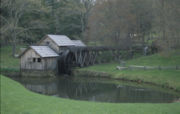
- 176.1 Mabry MillMabry MillMabry Mill is a watermill located at milepost 176.2 of Blue Ridge Parkway in Floyd County, Virginia. It is a tourist attraction mainly for the picturesque views of the mill itself. A short trail around the mill connects historical exhibits about life in rural Virginia...
was operated by E.B. Mabry from 1910 to 1935. A trail leads you to his gristmillGristmillThe terms gristmill or grist mill can refer either to a building in which grain is ground into flour, or to the grinding mechanism itself.- Early history :...
, sawmillSawmillA sawmill is a facility where logs are cut into boards.-Sawmill process:A sawmill's basic operation is much like those of hundreds of years ago; a log enters on one end and dimensional lumber exits on the other end....
, blacksmithBlacksmithA blacksmith is a person who creates objects from wrought iron or steel by forging the metal; that is, by using tools to hammer, bend, and cut...
shop, and to other exhibits. Old-time skills are demonstrated in the summer and fall. - 188.8 Groundhog Mountain is a good place to see different kinds of rural fences: snake, Post-and-rail, picketPicket fenceA picket fence is a variety of fence that has been used mostly for domestic boundaries. Until the introduction of advertising on fences in the 1980s, a Cricket field was also usually surrounded by a picket fence, giving rise to the expression rattling the pickets for a ball hit firmly into the...
and buck. PicnicPicnicIn contemporary usage, a picnic can be defined simply as a pleasure excursion at which a meal is eaten outdoors , ideally taking place in a beautiful landscape such as a park, beside a lake or with an interesting view and possibly at a public event such as before an open air theatre performance,...
grounds and observation tower.
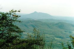
- 189.1 Pilot Mountain (North Carolina)Pilot Mountain (North Carolina)Pilot Mountain, a metamorphic quartzite monadnock rising to a peak above sea level, is one of the most distinctive natural features in the state of North Carolina. It is a remnant of the ancient chain of Sauratown Mountains. The Saura were the earliest known inhabitants of the region...
- 189.9 Aunt Orelena Puckett Cabin Exhibit was the home of an area midwife.
- 213 Blue Ridge Music CenterBlue Ridge Music CenterThe Blue Ridge Music Center is part of the Blue Ridge Parkway system and is located at Milepost 213 near Galax, Virginia. The center celebrates the history and performance of old time mountain music of Virginia and North Carolina and is largely concerned with local artists who best show this...
near the town of GalaxGalax, VirginiaGalax is an independent city in the southwestern part of the Commonwealth of Virginia. It is bounded to the northeast by Carroll County and to the southwest by Grayson County. The population was 7,042 as of 2010...
with concerts, music demonstrations, and a 17000 square feet (1,579.4 m²) museumMuseumA museum is an institution that cares for a collection of artifacts and other objects of scientific, artistic, cultural, or historical importance and makes them available for public viewing through exhibits that may be permanent or temporary. Most large museums are located in major cities...
dedicated to anything musical, especially old time music.
Highlights in North Carolina
North Carolina
North Carolina is a state located in the southeastern United States. The state borders South Carolina and Georgia to the south, Tennessee to the west and Virginia to the north. North Carolina contains 100 counties. Its capital is Raleigh, and its largest city is Charlotte...
-Virginia
Virginia
The Commonwealth of Virginia , is a U.S. state on the Atlantic Coast of the Southern United States. Virginia is nicknamed the "Old Dominion" and sometimes the "Mother of Presidents" after the eight U.S. presidents born there...
state line at mile 216.9. The 1749 party that surveyed the boundary included Peter Jefferson
Peter Jefferson
Peter Jefferson was the father of American President Thomas Jefferson . A surveyor and cartographer, his Fry-Jefferson Map of 1751 accurately depicted the Allegheny Mountains for the first time and showed the route of "The Great Road from the Yadkin River thro Virginia to Philadelphia distant 455...
, father of Thomas Jefferson
Thomas Jefferson
Thomas Jefferson was the principal author of the United States Declaration of Independence and the Statute of Virginia for Religious Freedom , the third President of the United States and founder of the University of Virginia...
.
- Mile 217.5 Cumberland Knob, at 2885 feet (879.3 m), is a delightful spot to walk through fields and woodlands.
- 218.6 Fox Hunters Paradise, a 10-minute walk, is where huntersFox huntingFox hunting is an activity involving the tracking, chase, and sometimes killing of a fox, traditionally a red fox, by trained foxhounds or other scent hounds, and a group of followers led by a master of foxhounds, who follow the hounds on foot or on horseback.Fox hunting originated in its current...
could listen to their houndHoundA hound is a type of dog that assists hunters by tracking or chasing the animal being hunted. It can be contrasted with the gun dog, which assists hunters by identifying the location of prey, and with the retriever, which recovers shot quarry...
s baying in the valley below. - 238.5 Brinegar Cabin was built by Martin Brinegar about 1880 and lived in until the 1930s when the homesteadHomesteadingBroadly defined, homesteading is a lifestyle of simple self-sufficiency.-Current practice:The term may apply to anyone who follows the back-to-the-land movement by adopting a sustainable, self-sufficient lifestyle. While land is no longer freely available in most areas of the world, homesteading...
was purchased from his widowWidowA widow is a woman whose spouse has died, while a widower is a man whose spouse has died. The state of having lost one's spouse to death is termed widowhood or occasionally viduity. The adjective form is widowed...
for the parkway. The original cabin stands there today. - 238.5 to 244.7 Doughton Park was named for Congressman Robert L. DoughtonRobert L. DoughtonRobert Lee "Bob" Doughton , of Alleghany County, North Carolina, sometimes known as "Farmer Bob," was a member of the United States House of Representatives from North Carolina for 42 consecutive years...
, a staunch supporter and neighbor of the parkway. One of the best places to see deerDeerDeer are the ruminant mammals forming the family Cervidae. Species in the Cervidae family include white-tailed deer, elk, moose, red deer, reindeer, fallow deer, roe deer and chital. Male deer of all species and female reindeer grow and shed new antlers each year...
. Campground. - 258.6 Northwest Trading Post offers crafts from North Carolina's northwestern counties.
- 260.6 Jumpinoff Rock, at the end of a short woodland trail, offers a beautiful vista.
- 264.4 The Lump provides sweeping views of the forested foothillsFoothillsFoothills are geographically defined as gradual increases in elevation at the base of a mountain range. They are a transition zone between plains and low relief hills to the adjacent topographically high mountains.-Examples:...
. - 272 E. B. Jeffress Park has a self-guided trailSelf-guided tourA self-guided tour is a self-governing tour where one navigates a route oneself as opposed to an escorted tour where a tour guide directs the route, times, information, and places toured...
to the Cascades. Another trail goes to the oldOld- Age :*Old age or, by extension, a description or nickname for someone or something that has endured and become comfortable or widely familiar.- Places :*Old, Hungary*Old, Northamptonshire, England...
cabinLog cabinA log cabin is a house built from logs. It is a fairly simple type of log house. A distinction should be drawn between the traditional meanings of "log cabin" and "log house." Historically most "Log cabins" were a simple one- or 1½-story structures, somewhat impermanent, and less finished or less...
and church. - 285.1 Daniel BooneDaniel BooneDaniel Boone was an American pioneer, explorer, and frontiersman whose frontier exploits mad']'e him one of the first folk heroes of the United States. Boone is most famous for his exploration and settlement of what is now the Commonwealth of Kentucky, which was then beyond the western borders of...
's Trace, which Boone blazedTrail blazingTrail blazing, or trailblazing, is the practice of marking paths in outdoor recreational areas with blazes, markings that follow each other at certain — though not necessarily exactly defined — distances and mark the direction of the trail...
to the West, crosses near here. - 292 to 295 Moses H. Cone Memorial ParkMoses H. Cone Memorial ParkThe Moses H. Cone Memorial Park is a country estate in honor of Moses H. Cone in Blowing Rock, North Carolina. It is on the Blue Ridge Parkway between mileposts 292 and 295 with access at Milepost 294. Most locals call it Cone Park. The park is run by the National Park Service and is open to the...
has hikingHikingHiking is an outdoor activity which consists of walking in natural environments, often in mountainous or other scenic terrain. People often hike on hiking trails. It is such a popular activity that there are numerous hiking organizations worldwide. The health benefits of different types of hiking...
, fishingFishingFishing is the activity of trying to catch wild fish. Fish are normally caught in the wild. Techniques for catching fish include hand gathering, spearing, netting, angling and trapping....
and horseEquestrianismEquestrianism more often known as riding, horseback riding or horse riding refers to the skill of riding, driving, or vaulting with horses...
trailTrailA trail is a path with a rough beaten or dirt/stone surface used for travel. Trails may be for use only by walkers and in some places are the main access route to remote settlements...
s. Flat Top ManorFlat Top ManorFlat Top Manor, as it is known to the locals, is also referred to as Moses Cone Manor, Moses Cone Estate, the Moses H. Cone Mansion, or just Flat Top. On the Blue Ridge Parkway it is located at Milepost 294 in Blowing Rock, North Carolina...
, the house of Moses H. ConeMoses H. ConeMoses Herman Cone was an American textile entrepreneur, conservationist, and philanthropist of the Gilded Age who was active in the southern United States...
has Parkway Craft Center. - 295.1 to 298 Julian Price Memorial ParkJulian Price Memorial ParkJulian Price Memorial Park is a park of at the foot of Grandfather Mountain in North Carolina, named in honor of Julian Price. It is at milepost 297 on the Blue Ridge Parkway and directly adjacent to the Moses H. Cone Memorial Park. Together these parks comprise the largest developed area set...
, the former retreat of the insurance executive Julian PriceJulian PriceJulian Price was an insurance executive who made his fortune in the first part of the twentieth century by developing the Jefferson Standard Life Insurance Company, at the time the largest corporation in North Carolina....
, offers a variety of short trails and a 47 acres (190,202.4 m²) lake. - 304.4 Linn Cove ViaductLinn Cove ViaductLinn Cove Viaduct is a 1243-foot concrete segmental bridge which snakes around the slopes of Grandfather Mountain in North Carolina. It was completed in 1983 at a cost of $10 million and was the last section of the Blue Ridge Parkway to be finished...
, a design and engineeringEngineeringEngineering is the discipline, art, skill and profession of acquiring and applying scientific, mathematical, economic, social, and practical knowledge, in order to design and build structures, machines, devices, systems, materials and processes that safely realize improvements to the lives of...
marvel, skirts the side of Grandfather MountainGrandfather MountainGrandfather Mountain is a mountain, a non-profit attraction, and a North Carolina state parknear Linville, North Carolina. At 5,946 feet , it is the highest peak on the eastern escarpment of the Blue Ridge Mountains, one of the major chains of the Appalachian Mountains. The Blue Ridge Parkway...
. Visitor center and trails. - 308.3 Flat Rock is worth the walk for the superb view of Grandfather MountainGrandfather MountainGrandfather Mountain is a mountain, a non-profit attraction, and a North Carolina state parknear Linville, North Carolina. At 5,946 feet , it is the highest peak on the eastern escarpment of the Blue Ridge Mountains, one of the major chains of the Appalachian Mountains. The Blue Ridge Parkway...
and Linville ValleyLinville, North CarolinaLinville is a community centered just south of the US 221 and NC 105 intersection in Avery County, North Carolina. The community -- at times known as Clay or Porcelain -- was founded in 1883 and designed by Samuel T. Kelsey of Kansas, it was named for William and John Linville, who were killed by...
.
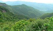
- 316.3 Linville FallsLinville FallsLinville Falls is a waterfall located in the Blue Ridge Mountains of North Carolina in the United States. The falls move in several distinct steps, beginning in a twin set of upper falls, moving down a small gorge, and finally culminating in a high-volume drop. It is named for the Linville...
roars through the dramatic rugged Linville GorgeLinville Gorge WildernessThe Linville Gorge Wilderness is the third largest wilderness area in North Carolina and one of only two wilderness gorges in the Southern United States...
. Trails to overlooks. - 320.7 Chestoa View trail provides outstanding scenery.
- 331 Museum of North Carolina Minerals interprets the state's mineral wealth.
- 339.5 Crabtree Meadows & Crabtree Falls (North Carolina)Crabtree Falls (North Carolina)Crabtree Falls is a waterfall in Yancey County, North Carolina.-Geology and Natural History:Crabtree Falls is a 70 ft. cascade on Big Crabtree Creek. The creek spreads over a rock face with many small ledges, giving it a delicate appearance, before trickling into a clear pool at the base...
Campground, Giftshop & Hiking Trails to Crabtree Falls. - 355.4 Mount Mitchell State ParkMount Mitchell State ParkMount Mitchell State Park is a North Carolina state park in Yancey County, North Carolina in the United States. Established in 1915 by the state legislature, it became the first state park of North Carolina...
, reached via N.C. 128, has a picnicPicnicIn contemporary usage, a picnic can be defined simply as a pleasure excursion at which a meal is eaten outdoors , ideally taking place in a beautiful landscape such as a park, beside a lake or with an interesting view and possibly at a public event such as before an open air theatre performance,...
area, lookout tower, and the highest point east of the Mississippi RiverMississippi RiverThe Mississippi River is the largest river system in North America. Flowing entirely in the United States, this river rises in western Minnesota and meanders slowly southwards for to the Mississippi River Delta at the Gulf of Mexico. With its many tributaries, the Mississippi's watershed drains...
. - 361.2 Glassmine FallsGlassmine FallsGlassmine Falls is an ephemeral waterfall in Buncombe County, North Carolina, on Glassmine Branch, near Dillingham, North Carolina.-Geology:When it flows, the falls slides down the rock face of Blackstop Knob Mountain down to the North Fork Swannanoa River. The flow is not constant and can...
, an 800 feet (243.8 m) ephemeral waterfall visible from an overlook on the side of the parkway. - 363.4 to 369.6 Craggy Gardens in the Great Craggy MountainsGreat Craggy MountainsThe Great Craggy Mountains, commonly called the Craggies, are a mountain range in western North Carolina, United States. They are a subrange of the Blue Ridge Mountains and encompass an area of approx. 194 sq mi . They are situated in Buncombe County, North Carolina, 14 miles northeast of Asheville...
appear covered with purple rhododendronRhododendronRhododendron is a genus of over 1 000 species of woody plants in the heath family, most with showy flowers...
in mid to late June. Craggy Pinnacle Trail and other trails (364.1 and 364.6); road to picnic area and trails (367.6). - 382 The Folk Art CenterFolk Art CenterThe Folk Art Center is a museum of Appalachian arts and crafts located at milepost 382 on the Blue Ridge Parkway near Asheville, North Carolina...
is the flagship facility of the Southern Highland Craft GuildSouthern Highland Craft GuildSouthern Highland Craft Guild is a guild craft organization that has partnered with the National Park Service for over fifty years. The Guild represents over 1000 craftspeople in 293 counties of 9 southeastern states. It operates five retail craft shops and two annual craft expositions which...
. It offers sales and exhibits of traditional and contemporary crafts of the Appalachian region. Interpretive programs, three galleries, a library and a book store. - 384 The Blue Ridge Parkway Visitor Center is the newest attraction along the Parkway. The building itself is LEED- certified http://www.usgbc.org/DisplayPage.aspx?CMSPageID=222 and reflects the cutting edge of energy-saving technology. The Center houses a 70-seat theater showing an award-winning 24 minute film about the region. Information and orientation services are provided by the National Park Service and the Blue Ridge National Heritage Area. Eastern National has a retail shop offering books, apparel and more. There are several exhibits, including a 22-foot interactive map of the entire Blue Ridge Parkway known as the "I-Wall" which provides multi-media information on places to visit on and around the Parkway. Other exhibits focus on the history and heritage of the Parkway and Western North Carolina. Open year-round from 9am-5pm.
- 408.6 Mount PisgahMount Pisgah (North Carolina)Mount Pisgah is a mountain in the Appalachian Mountain Range and part of the Blue Ridge Mountains of North Carolina, United States. The mountain's height is 5,721 feet and it sits approximately 15 miles southwest of Asheville near the crossing of the boundaries of Buncombe, Haywood, Henderson...
was part of the Biltmore EstateBiltmore EstateBiltmore House is a Châteauesque-styled mansion near Asheville, North Carolina, built by George Washington Vanderbilt II between 1889 and 1895. It is the largest privately-owned home in the United States, at and featuring 250 rooms...
. The estate became home of the first forestry school in America and the nucleus of the Pisgah National ForestPisgah National ForestPisgah National Forest is a National Forest in the Appalachian Mountains of western North Carolina. It is administered by the United States Forest Service, part of the United States Department of Agriculture. The Pisgah National Forest is completely contained within the state of North Carolina...
.
- 417 Looking Glass RockLooking Glass RockLooking Glass Rock is a pluton monolith in the Appalachian Mountains of western North Carolina. The mountain is located within Pisgah National Forest about 5.5 miles northwest of Brevard and 25 miles southwest of Asheville...
is visible from many spots on the Parkway starting at Mount Pisgah. - 418 East Fork Overlook. Located here are the headwaters of the Pigeon River. Yellowstone Falls is a short distance away and gets its name from the yellowish moss covering the rocks. You can find U.S. Forest Service trail access to Shining Rock Wilderness Trail system here.
- 420.2 Shining Rock WildernessShining Rock WildernessThe Shining Rock Wilderness is a protected Wilderness Area in the U.S. state of North Carolina. Its first have been part of the National Wilderness Preservation System since the System was created in 1964...
is the largest WildernessWildernessWilderness or wildland is a natural environment on Earth that has not been significantly modified by human activity. It may also be defined as: "The most intact, undisturbed wild natural areas left on our planet—those last truly wild places that humans do not control and have not developed with...
in North CarolinaNorth CarolinaNorth Carolina is a state located in the southeastern United States. The state borders South Carolina and Georgia to the south, Tennessee to the west and Virginia to the north. North Carolina contains 100 counties. Its capital is Raleigh, and its largest city is Charlotte...
with 18483 acres (74.8 km²), 25 miles (40.2 km) of trails and peaks over 6000 ft (1,828.8 m). The Wilderness is named for Shining RockShining RockShining Rock is a mountain in western North Carolina. The mountain is one of the Great Balsam Mountains which are a part of the Blue Ridge Mountains within the Appalachian Mountains. It is the 38th tallest mountain in the eastern United States....
. - 420.2 Black Balsam KnobBlack Balsam KnobBlack Balsam Knob, also known as Black Balsam Bald, is in the Pisgah National Forest southwest of Asheville, NC near milepost 420 on the Blue Ridge Parkway....
is a grassy baldAppalachian baldsIn the Appalachian Mountains of the eastern United States, balds are mountain summits or crests covered primarily by thick vegetation of native grasses or shrubs occurring in areas where heavy forest growth would be expected....
with panoramic views just outside of the Shining Rock WildernessShining Rock WildernessThe Shining Rock Wilderness is a protected Wilderness Area in the U.S. state of North Carolina. Its first have been part of the National Wilderness Preservation System since the System was created in 1964...
in Pisgah National ForestPisgah National ForestPisgah National Forest is a National Forest in the Appalachian Mountains of western North Carolina. It is administered by the United States Forest Service, part of the United States Department of Agriculture. The Pisgah National Forest is completely contained within the state of North Carolina...
. The Wilderness also includes Cold Mountain. - 422.4 Devil's CourthouseDevil's CourthouseDevil's Courthouse refers to two locations:* A great overhang of Whiteside Mountain in Jackson County, NC* A mountain in Transylvania County, NCThis article concerns the mountain in Transylvania County, NC....
is a rugged exposed mountaintop rich in CherokeeCherokeeThe Cherokee are a Native American people historically settled in the Southeastern United States . Linguistically, they are part of the Iroquoian language family...
traditions. A walk to the bare rock summit yields a spectacular view of Pisgah National ForestPisgah National ForestPisgah National Forest is a National Forest in the Appalachian Mountains of western North Carolina. It is administered by the United States Forest Service, part of the United States Department of Agriculture. The Pisgah National Forest is completely contained within the state of North Carolina...
. - 423.5 Herrin Knob Overlook. A hiking trail goes around Tanasee BaldTanasee BaldTanasee Bald, also called Tennessee Bald, is a mountain near the Blue Ridge Parkway in western North Carolina, on the Haywood/Transylvania border. It is 5561 feet high...
and Herrin Knob. Tanasee BaldTanasee BaldTanasee Bald, also called Tennessee Bald, is a mountain near the Blue Ridge Parkway in western North Carolina, on the Haywood/Transylvania border. It is 5561 feet high...
(423.7) is said to be the home of the mythical Cherokee giant Tsul 'KaluTsul 'KaluTsul 'Kalu , is a legendary figure in Cherokee mythology who plays the role of "the great lord of the game", and as such is frequently invoked in hunting rites and rituals...
. - 431 Richland BalsamRichland BalsamRichland Balsam is a mountain in the Great Balsam Mountains in the U.S. state of North Carolina. Rising to an elevation of , it is the highest mountain in the Great Balsam range and is among the 20 highest summits in the Appalachian range. The Blue Ridge Parkway reaches an elevation of —...
's self-guiding trail takes you through a remnant spruceSpruceA spruce is a tree of the genus Picea , a genus of about 35 species of coniferous evergreen trees in the Family Pinaceae, found in the northern temperate and boreal regions of the earth. Spruces are large trees, from tall when mature, and can be distinguished by their whorled branches and conical...
-fir forest. Highest point on the parkway, 6053 feet (1,845 m). - 451.2 Waterrock KnobWaterrock KnobWaterrock Knob is a mountain peak in the U.S. state of North Carolina. It is the highest peak in the Plott Balsams and is the 16th highest mountain in the Eastern United States. It is the 15th highest of the 40 mountains in North Carolina over 6000 feet....
provides a panorama of the Great SmokiesGreat Smoky MountainsThe Great Smoky Mountains are a mountain range rising along the Tennessee–North Carolina border in the southeastern United States. They are a subrange of the Appalachian Mountains, and form part of the Blue Ridge Physiographic Province. The range is sometimes called the Smoky Mountains or the...
, visitor center, trail, confort station, exhibits.
- 458.2 Heintooga Overlook spur road goes to a mile-high overlook 1.3 miles (2.1 km) from the parkway.
- Mile 469 Southern End of the Blue Ridge Parkway intersects with U.S. 441 in the Great Smoky Mountains National ParkGreat Smoky Mountains National ParkGreat Smoky Mountains National Park is a United States National Park and UNESCO World Heritage Site that straddles the ridgeline of the Great Smoky Mountains, part of the Blue Ridge Mountains, which are a division of the larger Appalachian Mountain chain. The border between Tennessee and North...
and the Cherokee ReservationCherokee, North CarolinaCherokee is a town in Swain County, North Carolina, USA, within the Qualla Boundary land trust. It is located in the Oconaluftee River Valley, near the intersection of U.S. Route 19 and U.S...
.
Closures
It is not unusual for small sections of the Parkway to be temporarily closed to repair damage caused by the cold winter climate of the mountains or for other maintenance. Detours caused by these closures are well-marked, and are arranged to cause as little disruption as possible.Due to serious damage in 2004 from Hurricane Frances
Hurricane Frances
Hurricane Frances was the sixth named storm, the fourth hurricane, and the third major hurricane of the 2004 Atlantic hurricane season. The system crossing the open Atlantic during mid to late August, moving to the north of the Lesser Antilles while strengthening. Its outer bands affected Puerto...
, then again by Hurricane Ivan
Hurricane Ivan
Hurricane Ivan was a large, long-lived, Cape Verde-type hurricane that caused widespread damage in the Caribbean and United States. The cyclone was the ninth named storm, the sixth hurricane and the fourth major hurricane of the active 2004 Atlantic hurricane season...
, many areas along the parkway were closed until the spring of 2005, with two areas that were not fully repaired until the spring of 2006. These sections are now open.
Partners
(Much of this information comes from the Blue Ridge Parkway Foundation's Partners page)The Blue Ridge Parkway is a National Park
National park
A national park is a reserve of natural, semi-natural, or developed land that a sovereign state declares or owns. Although individual nations designate their own national parks differently A national park is a reserve of natural, semi-natural, or developed land that a sovereign state declares or...
site and while its operations budget is funded by the United States Congress
United States Congress
The United States Congress is the bicameral legislature of the federal government of the United States, consisting of the Senate and the House of Representatives. The Congress meets in the United States Capitol in Washington, D.C....
, it works with many partner organizations that have unique roles in supporting it:
- Blue Ridge Parkway Association is a membership organization that includes Parkway attractions, outdoor recreation, accommodations, restaurants, shops, and a variety of other services for the Parkway traveler;
- The Blue Ridge Parkway FoundationBlue Ridge Parkway FoundationThe Blue Ridge Parkway Foundation, in Winston-Salem, North Carolina is a non-profit organization classified as a 501 by the Internal Revenue Service. The Foundation was created in 1997 to raise private funding for the Blue Ridge Parkway....
is the primary and professional fundraising organization for the Blue Ridge Parkway. - The Blue Ridge National Heritage Area, designated in 2003, recognizes the unique character, culture, and natural beauty of Western North Carolina;
- Eastern NationalEastern NationalEastern National is a non-profit organization based in Fort Washington, Pennsylvania, that partners with the National Park Service in the United States...
is the principle provider of quality educational products and services to the visitors to America's national parks; - The Friends of the Blue Ridge Parkway primary mission is to mobilize and provide leadership for volunteers who assist with a wide variety of Parkway projects;
- The National Council for Traditional Arts supports the Blue Ridge Music Center in Galax, VirginiaGalax, VirginiaGalax is an independent city in the southwestern part of the Commonwealth of Virginia. It is bounded to the northeast by Carroll County and to the southwest by Grayson County. The population was 7,042 as of 2010...
; - The Southern Highland Craft GuildSouthern Highland Craft GuildSouthern Highland Craft Guild is a guild craft organization that has partnered with the National Park Service for over fifty years. The Guild represents over 1000 craftspeople in 293 counties of 9 southeastern states. It operates five retail craft shops and two annual craft expositions which...
has galleries at the Moses H. Cone Memorial Park in Blowing Rock, North CarolinaBlowing Rock, North CarolinaBlowing Rock is a town in North Carolina, USA, situated in both Caldwell and Watauga counties. The population was 1,418 at the 2000 census. However, during the summer the town's population increases to about 10,000.]]\\...
and at the Folk Art Center in Asheville, North CarolinaAsheville, North CarolinaAsheville is a city in and the county seat of Buncombe County, North Carolina, United States. It is the largest city in Western North Carolina, and the 11th largest city in North Carolina. The City is home to the United States National Climatic Data Center , which is the world's largest active...
; - Western Virginia Land Trust protects lands in southwest Virginia and promotes conservation and stewardship of the Blue Ridge Parkway in southwest Virginia.
- Conservation Trust for North Carolina is a land trust that protects natural resources along the Parkway corridor; in 1996, Gov. Jim Hunt's "Year of the Mountains Commission" appointed CTNC to assume leadership in protecting the Blue Ridge Parkway’s natural and scenic corridor in North Carolina.
See also
- Natchez Trace ParkwayNatchez Trace ParkwayThe Natchez Trace Parkway is a National Park Service unit in the southeastern United States that commemorates the historic Old Natchez Trace and preserves sections of the original trail....
- Mountains-to-Sea TrailMountains-to-Sea TrailThe Mountains-to-Sea Trail is a long-distance trail, for hiking and backpacking, that runs across North Carolina from the Great Smoky Mountains to the Outer Banks. The trail's western endpoint is at Clingman's Dome, where it connects to the Appalachian Trail in the Great Smoky Mountains National...
- Cherohala SkywayCherohala SkywayThe Cherohala Skyway is a National Scenic Byway that connects Tellico Plains, Tennessee, to Robbinsville, North Carolina in the southeastern United States. Its name is a portmanteau of Cherokee and Nantahala, the two national forests through which it passes...
External links
- National Park Service: Current Blue Ridge Parkway Road Closures
- National Park Service: Blue Ridge Parkway
- Blue Ridge Parkway Association
- Design and Construction of the Blue Ridge Parkway
- Blue Ridge Parkway in Virginia
- Blue Ridge National Heritage Area
- Friends of the Blue Ridge Parkway
- Blue Ridge Parkway Foundation
- Conservation Trust for North Carolina
- Blue Ridge Parkway In North Carolina