
Windward Islands
Encyclopedia
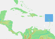
The Windward Islands are the southern islands of the Lesser Antilles
, within the West Indies.
s arriving in the New World
than the Leeward Islands
, given that the prevailing trade wind
s in the West Indies
blow east to west. The trans-Atlantic currents and winds that provided the fastest route across the ocean brought these ships to the rough dividing line between the Windward and Leeward islands. Vessels in the Atlantic slave trade
departing from the Africa
n Gold Coast
and Gulf of Guinea
would first encounter the southeasternmost islands of the Lesser Antilles in their west-northwesterly heading to final destinations in the Caribbean
and North
and Central America
. The chain of islands form a part of the easternmost boundary of the Caribbean Sea
.
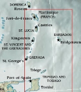
The Antillean Windward Islands from north to south are:
Barbados
, Trinidad and Tobago
do not consider themselves part of the Windward Islands but are sometimes included due to proximity and the fact that they are windward relative to other Caribbean isles.
in English.
Lesser Antilles
The Lesser Antilles are a long, partly volcanic island arc in the Western Hemisphere. Most of its islands form the eastern boundary of the Caribbean Sea with the Atlantic Ocean, with the remainder located in the southern Caribbean just north of South America...
, within the West Indies.
Name and geography
The Windward Islands are called such because they were more windward to sailing shipSailing ship
The term sailing ship is now used to refer to any large wind-powered vessel. In technical terms, a ship was a sailing vessel with a specific rig of at least three masts, square rigged on all of them, making the sailing adjective redundant. In popular usage "ship" became associated with all large...
s arriving in the New World
New World
The New World is one of the names used for the Western Hemisphere, specifically America and sometimes Oceania . The term originated in the late 15th century, when America had been recently discovered by European explorers, expanding the geographical horizon of the people of the European middle...
than the Leeward Islands
Leeward Islands
The Leeward Islands are a group of islands in the West Indies. They are the northern islands of the Lesser Antilles chain. As a group they start east of Puerto Rico and reach southward to Dominica. They are situated where the northeastern Caribbean Sea meets the western Atlantic Ocean...
, given that the prevailing trade wind
Trade wind
The trade winds are the prevailing pattern of easterly surface winds found in the tropics, within the lower portion of the Earth's atmosphere, in the lower section of the troposphere near the Earth's equator...
s in the West Indies
British West Indies
The British West Indies was a term used to describe the islands in and around the Caribbean that were part of the British Empire The term was sometimes used to include British Honduras and British Guiana, even though these territories are not geographically part of the Caribbean...
blow east to west. The trans-Atlantic currents and winds that provided the fastest route across the ocean brought these ships to the rough dividing line between the Windward and Leeward islands. Vessels in the Atlantic slave trade
Atlantic slave trade
The Atlantic slave trade, also known as the trans-atlantic slave trade, refers to the trade in slaves that took place across the Atlantic ocean from the sixteenth through to the nineteenth centuries...
departing from the Africa
Africa
Africa is the world's second largest and second most populous continent, after Asia. At about 30.2 million km² including adjacent islands, it covers 6% of the Earth's total surface area and 20.4% of the total land area...
n Gold Coast
Gold Coast (British colony)
The Gold Coast was a British colony on the Gulf of Guinea in west Africa that became the independent nation of Ghana in 1957.-Overview:The first Europeans to arrive at the coast were the Portuguese in 1471. They encountered a variety of African kingdoms, some of which controlled substantial...
and Gulf of Guinea
Gulf of Guinea
The Gulf of Guinea is the northeasternmost part of the tropical Atlantic Ocean between Cape Lopez in Gabon, north and west to Cape Palmas in Liberia. The intersection of the Equator and Prime Meridian is in the gulf....
would first encounter the southeasternmost islands of the Lesser Antilles in their west-northwesterly heading to final destinations in the Caribbean
Caribbean
The Caribbean is a crescent-shaped group of islands more than 2,000 miles long separating the Gulf of Mexico and the Caribbean Sea, to the west and south, from the Atlantic Ocean, to the east and north...
and North
North America
North America is a continent wholly within the Northern Hemisphere and almost wholly within the Western Hemisphere. It is also considered a northern subcontinent of the Americas...
and Central America
Central America
Central America is the central geographic region of the Americas. It is the southernmost, isthmian portion of the North American continent, which connects with South America on the southeast. When considered part of the unified continental model, it is considered a subcontinent...
. The chain of islands form a part of the easternmost boundary of the Caribbean Sea
Caribbean Sea
The Caribbean Sea is a sea of the Atlantic Ocean located in the tropics of the Western hemisphere. It is bounded by Mexico and Central America to the west and southwest, to the north by the Greater Antilles, and to the east by the Lesser Antilles....
.
The Antillean Windward Islands from north to south are:
- DominicaDominicaDominica , officially the Commonwealth of Dominica, is an island nation in the Lesser Antilles region of the Caribbean Sea, south-southeast of Guadeloupe and northwest of Martinique. Its size is and the highest point in the country is Morne Diablotins, which has an elevation of . The Commonwealth...
- MartiniqueMartiniqueMartinique is an island in the eastern Caribbean Sea, with a land area of . Like Guadeloupe, it is an overseas region of France, consisting of a single overseas department. To the northwest lies Dominica, to the south St Lucia, and to the southeast Barbados...
(an overseas department of FranceFranceThe French Republic , The French Republic , The French Republic , (commonly known as France , is a unitary semi-presidential republic in Western Europe with several overseas territories and islands located on other continents and in the Indian, Pacific, and Atlantic oceans. Metropolitan France...
) - Saint LuciaSaint LuciaSaint Lucia is an island country in the eastern Caribbean Sea on the boundary with the Atlantic Ocean. Part of the Lesser Antilles, it is located north/northeast of the island of Saint Vincent, northwest of Barbados and south of Martinique. It covers a land area of 620 km2 and has an...
- Saint VincentSaint Vincent (island)Saint Vincent is a volcanic island in the Caribbean. It is the largest island of the chain called Saint Vincent and the Grenadines. It is located in the Caribbean Sea, between Saint Lucia and Grenada. It is composed of partially submerged volcanic mountains...
- GrenadinesGrenadinesThe Grenadines is a Caribbean island chain of over 600 islands in the Windward Islands.-Geographic boundaries:They are divided between the island nations of Saint Vincent and the Grenadines and Grenada. They lie between the islands of Saint Vincent in the north and Grenada in the south. Neither...
- GrenadaGrenadaGrenada is an island country and Commonwealth Realm consisting of the island of Grenada and six smaller islands at the southern end of the Grenadines in the southeastern Caribbean Sea...
Barbados
Barbados
Barbados is an island country in the Lesser Antilles. It is in length and as much as in width, amounting to . It is situated in the western area of the North Atlantic and 100 kilometres east of the Windward Islands and the Caribbean Sea; therein, it is about east of the islands of Saint...
, Trinidad and Tobago
Trinidad and Tobago
Trinidad and Tobago officially the Republic of Trinidad and Tobago is an archipelagic state in the southern Caribbean, lying just off the coast of northeastern Venezuela and south of Grenada in the Lesser Antilles...
do not consider themselves part of the Windward Islands but are sometimes included due to proximity and the fact that they are windward relative to other Caribbean isles.
Terminology
In languages other than English (i.e., Dutch, French, German and Spanish), and also in the local English of some islands, "windward" and "leeward" refer to different groups of islands. In both cases, the east/southeasternmost group are called windward, while the westernmost are called leeward. The group of islands along the Venezuelan coast is called the Leeward AntillesLeeward Antilles
The Leeward Antilles are a chain of islands in the Caribbean – specifically, the southerly islands of the Lesser Antilles along the southeastern fringe of the Caribbean Sea, just north of the Venezuelan coast of the South American mainland...
in English.
| Language | Windward Islands | Leeward Islands |
|---|---|---|
| English |  |
 |
| Others | 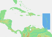 |
 |
See also
- Leeward IslandsLeeward IslandsThe Leeward Islands are a group of islands in the West Indies. They are the northern islands of the Lesser Antilles chain. As a group they start east of Puerto Rico and reach southward to Dominica. They are situated where the northeastern Caribbean Sea meets the western Atlantic Ocean...
- British Windward IslandsBritish Windward IslandsThe British Windward Islands was a British colony existing between 1833 and 1960 and consisting of the islands of Grenada, St Lucia, Saint Vincent, the Grenadines, Barbados , Tobago , and Dominica, previously included in the...
- Windward Islands cricket teamWindward Islands cricket teamThe Windward Islands cricket team is a cricket team representing the member countries of the Windward Islands Cricket Board of Control. The team plays in the West Indies regional tournament....
- Lesser AntillesLesser AntillesThe Lesser Antilles are a long, partly volcanic island arc in the Western Hemisphere. Most of its islands form the eastern boundary of the Caribbean Sea with the Atlantic Ocean, with the remainder located in the southern Caribbean just north of South America...