

North American Eastern Time Zone
Encyclopedia

United States
The United States of America is a federal constitutional republic comprising fifty states and a federal district...
and Canada
Canada
Canada is a North American country consisting of ten provinces and three territories. Located in the northern part of the continent, it extends from the Atlantic Ocean in the east to the Pacific Ocean in the west, and northward into the Arctic Ocean...
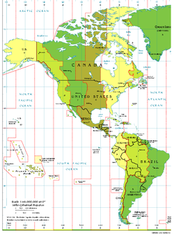
is a time zone
Time zone
A time zone is a region on Earth that has a uniform standard time for legal, commercial, and social purposes. In order for the same clock time to always correspond to the same portion of the day as the Earth rotates , different places on the Earth need to have different clock times...
that falls mostly along the east coast of North America
North America
North America is a continent wholly within the Northern Hemisphere and almost wholly within the Western Hemisphere. It is also considered a northern subcontinent of the Americas...
. Its UTC time offset is −5 hrs (UTC−05) during standard time
Standard time
Standard time is the result of synchronizing clocks in different geographical locations within a time zone to the same time rather than using the local meridian as in local mean time or solar time. Historically, this helped in the process of weather forecasting and train travel. The concept...
and −4 hrs (UTC−04) during daylight saving time
Daylight saving time
Daylight saving time —also summer time in several countries including in British English and European official terminology —is the practice of temporarily advancing clocks during the summertime so that afternoons have more daylight and mornings have less...
. The clock time in this zone is based on the mean solar time of the 75th meridian west
75th meridian west
The meridian 75° west of Greenwich is a line of longitude that extends from the North Pole across the Arctic Ocean, North America, the Atlantic Ocean, the Caribbean Sea, South America, the Pacific Ocean, the Southern Ocean, and Antarctica to the South Pole....
of the Greenwich Observatory.
In the United States
United States
The United States of America is a federal constitutional republic comprising fifty states and a federal district...
and Canada
Canada
Canada is a North American country consisting of ten provinces and three territories. Located in the northern part of the continent, it extends from the Atlantic Ocean in the east to the Pacific Ocean in the west, and northward into the Arctic Ocean...
, this time zone is generally called Eastern Time (ET). Specifically, it is Eastern Standard Time (EST) when observing standard time
Standard time
Standard time is the result of synchronizing clocks in different geographical locations within a time zone to the same time rather than using the local meridian as in local mean time or solar time. Historically, this helped in the process of weather forecasting and train travel. The concept...
(winter), and Eastern Daylight Time (EDT) when observing daylight saving time
Daylight saving time in the United States
Daylight saving time in the United States was first observed in 1918. Most areas of the United States currently observe daylight saving time, with the exceptions being the states of Arizona and Hawaii along with the territories of Puerto Rico, American Samoa, Guam, and the Northern Mariana...
(spring to autumn).
Since 2007, the local time changes at 02:00 EST to 03:00 EDT on the second Sunday in March and returns at 02:00 EDT to 01:00 EST on the first Sunday in November, in the U.S. as well as in Canada.
History
The 1966 Uniform Time ActUniform Time Act
The Uniform Time Act of 1966, , was a United States federal law to "promote the adoption and observance of uniform time within the standard time zones" prescribed by the Standard Time Act of 1918. Its intended effect was to simplify the official pattern of where and when daylight saving time is...
in the USA meant that EDT was instituted on the last Sunday in April, starting in 1966. EST would be re-instituted on the last Sunday in October. The act was amended to make the first Sunday in April the beginning of EDT as of 1987. The Energy Policy Act of 2005 extended daylight saving time in the U.S. beginning in 2007, so that the local time changes at 02:00 EST to 03:00 EDT on the second Sunday in March and returns at 02:00 EDT to 01:00 EST on the first Sunday in November. In Canada, the time changes as it does in the USA.
North America
Canada
In CanadaCanada
Canada is a North American country consisting of ten provinces and three territories. Located in the northern part of the continent, it extends from the Atlantic Ocean in the east to the Pacific Ocean in the west, and northward into the Arctic Ocean...
, the following provinces and territories
Provinces and territories of Canada
The provinces and territories of Canada combine to make up the world's second-largest country by area. There are ten provinces and three territories...
are part of the Eastern Time Zone:
- OntarioOntarioOntario is a province of Canada, located in east-central Canada. It is Canada's most populous province and second largest in total area. It is home to the nation's most populous city, Toronto, and the nation's capital, Ottawa....
(excluding areas west of Thunder BayThunder Bay-In Canada:Thunder Bay is the name of three places in the province of Ontario, Canada along Lake Superior:*Thunder Bay District, Ontario, a district in Northwestern Ontario*Thunder Bay, a city in Thunder Bay District*Thunder Bay, Unorganized, Ontario...
but including Atikokan) - QuebecQuebecQuebec or is a province in east-central Canada. It is the only Canadian province with a predominantly French-speaking population and the only one whose sole official language is French at the provincial level....
(excluding far eastern Côte-NordCôte-NordCôte-Nord is the second largest administrative region by land area in Quebec, Canada, after Nord-du-Québec...
and the Magdalen IslandsMagdalen IslandsThe Magdalen Islands form a small archipelago in the Gulf of Saint Lawrence with a land area of . Though closer to Prince Edward Island and Nova Scotia, the islands form part of the Canadian province of Quebec....
) - East-central NunavutNunavutNunavut is the largest and newest federal territory of Canada; it was separated officially from the Northwest Territories on April 1, 1999, via the Nunavut Act and the Nunavut Land Claims Agreement Act, though the actual boundaries had been established in 1993...
(including part of Melville PeninsulaMelville PeninsulaMelville Peninsula is a large peninsula in the Canadian Arctic. Since 1999, it has been part of Nunavut. Before that, it was part of the District of Franklin. It's separated from Southampton Island by Frozen Strait. The narrow isthmus connecting the peninsula to the mainland is styled the “Rae...
and most of EllesmereEllesmere IslandEllesmere Island is part of the Qikiqtaaluk Region of the Canadian territory of Nunavut. Lying within the Canadian Arctic Archipelago, it is considered part of the Queen Elizabeth Islands, with Cape Columbia being the most northerly point of land in Canada...
and BaffinBaffin IslandBaffin Island in the Canadian territory of Nunavut is the largest island in the Canadian Arctic Archipelago, the largest island in Canada and the fifth largest island in the world. Its area is and its population is about 11,000...
Islands, including Iqaluit; Southampton IslandSouthampton IslandSouthampton Island is a large island at the entrance to Hudson Bay at Foxe Basin. One of the larger members of the Canadian Arctic Archipelago, Southampton Island is part of the Kivalliq Region in Nunavut, Canada. The area of the island is stated as by Statistics Canada . It is the 34th largest...
does not observe DSTDaylight saving timeDaylight saving time —also summer time in several countries including in British English and European official terminology —is the practice of temporarily advancing clocks during the summertime so that afternoons have more daylight and mornings have less...
)
United States
In the United States the District of ColumbiaWashington, D.C.
Washington, D.C., formally the District of Columbia and commonly referred to as Washington, "the District", or simply D.C., is the capital of the United States. On July 16, 1790, the United States Congress approved the creation of a permanent national capital as permitted by the U.S. Constitution....
along with seventeen states are entirely located within the Eastern Time zone, while another six are split between the Eastern and Central time zones.
The seventeen states which observe only Eastern time are as follows.
- ConnecticutConnecticutConnecticut is a state in the New England region of the northeastern United States. It is bordered by Rhode Island to the east, Massachusetts to the north, and the state of New York to the west and the south .Connecticut is named for the Connecticut River, the major U.S. river that approximately...
- DelawareDelawareDelaware is a U.S. state located on the Atlantic Coast in the Mid-Atlantic region of the United States. It is bordered to the south and west by Maryland, and to the north by Pennsylvania...
- GeorgiaGeorgia (U.S. state)Georgia is a state located in the southeastern United States. It was established in 1732, the last of the original Thirteen Colonies. The state is named after King George II of Great Britain. Georgia was the fourth state to ratify the United States Constitution, on January 2, 1788...
- MaineMaineMaine is a state in the New England region of the northeastern United States, bordered by the Atlantic Ocean to the east and south, New Hampshire to the west, and the Canadian provinces of Quebec to the northwest and New Brunswick to the northeast. Maine is both the northernmost and easternmost...
- MarylandMarylandMaryland is a U.S. state located in the Mid Atlantic region of the United States, bordering Virginia, West Virginia, and the District of Columbia to its south and west; Pennsylvania to its north; and Delaware to its east...
- MassachusettsMassachusettsThe Commonwealth of Massachusetts is a state in the New England region of the northeastern United States of America. It is bordered by Rhode Island and Connecticut to the south, New York to the west, and Vermont and New Hampshire to the north; at its east lies the Atlantic Ocean. As of the 2010...
- New HampshireNew HampshireNew Hampshire is a state in the New England region of the northeastern United States of America. The state was named after the southern English county of Hampshire. It is bordered by Massachusetts to the south, Vermont to the west, Maine and the Atlantic Ocean to the east, and the Canadian...
- New JerseyNew JerseyNew Jersey is a state in the Northeastern and Middle Atlantic regions of the United States. , its population was 8,791,894. It is bordered on the north and east by the state of New York, on the southeast and south by the Atlantic Ocean, on the west by Pennsylvania and on the southwest by Delaware...
- New YorkNew YorkNew York is a state in the Northeastern region of the United States. It is the nation's third most populous state. New York is bordered by New Jersey and Pennsylvania to the south, and by Connecticut, Massachusetts and Vermont to the east...
- North CarolinaNorth CarolinaNorth Carolina is a state located in the southeastern United States. The state borders South Carolina and Georgia to the south, Tennessee to the west and Virginia to the north. North Carolina contains 100 counties. Its capital is Raleigh, and its largest city is Charlotte...
- OhioOhioOhio is a Midwestern state in the United States. The 34th largest state by area in the U.S.,it is the 7th‑most populous with over 11.5 million residents, containing several major American cities and seven metropolitan areas with populations of 500,000 or more.The state's capital is Columbus...
- PennsylvaniaPennsylvaniaThe Commonwealth of Pennsylvania is a U.S. state that is located in the Northeastern and Mid-Atlantic regions of the United States. The state borders Delaware and Maryland to the south, West Virginia to the southwest, Ohio to the west, New York and Ontario, Canada, to the north, and New Jersey to...
- Rhode IslandRhode IslandThe state of Rhode Island and Providence Plantations, more commonly referred to as Rhode Island , is a state in the New England region of the United States. It is the smallest U.S. state by area...
- South CarolinaSouth CarolinaSouth Carolina is a state in the Deep South of the United States that borders Georgia to the south, North Carolina to the north, and the Atlantic Ocean to the east. Originally part of the Province of Carolina, the Province of South Carolina was one of the 13 colonies that declared independence...
- VermontVermontVermont is a state in the New England region of the northeastern United States of America. The state ranks 43rd in land area, , and 45th in total area. Its population according to the 2010 census, 630,337, is the second smallest in the country, larger only than Wyoming. It is the only New England...
- VirginiaVirginiaThe Commonwealth of Virginia , is a U.S. state on the Atlantic Coast of the Southern United States. Virginia is nicknamed the "Old Dominion" and sometimes the "Mother of Presidents" after the eight U.S. presidents born there...
- West VirginiaWest VirginiaWest Virginia is a state in the Appalachian and Southeastern regions of the United States, bordered by Virginia to the southeast, Kentucky to the southwest, Ohio to the northwest, Pennsylvania to the northeast and Maryland to the east...
The exact specification for the location of time zone
Time zone
A time zone is a region on Earth that has a uniform standard time for legal, commercial, and social purposes. In order for the same clock time to always correspond to the same portion of the day as the Earth rotates , different places on the Earth need to have different clock times...
s and the dividing line between zones is set forth in the Code of Federal Regulations
Code of Federal Regulations
The Code of Federal Regulations is the codification of the general and permanent rules and regulations published in the Federal Register by the executive departments and agencies of the Federal Government of the United States.The CFR is published by the Office of the Federal Register, an agency...
at 49 CFR 71.
These six states are split between Eastern and Central time.
- AlabamaAlabamaAlabama is a state located in the southeastern region of the United States. It is bordered by Tennessee to the north, Georgia to the east, Florida and the Gulf of Mexico to the south, and Mississippi to the west. Alabama ranks 30th in total land area and ranks second in the size of its inland...
: The entire state is officially in the Central Time Zone. However, a handful of communities unofficially observe Eastern Time because they are part of the Columbus, GeorgiaColumbus, GeorgiaColumbus is a city in and the county seat of Muscogee County, Georgia, United States, with which it is consolidated. As of the 2010 census, the city had a population of 189,885. It is the principal city of the Columbus, Georgia metropolitan area, which, in 2009, had an estimated population of 292,795...
metropolitan area – Phenix CityPhenix City, AlabamaPhenix City is a city and the county seat in Russell County in the U.S. state of Alabama. Portions of Lee County are addressed as Phenix City, 36870 ZIP code, for the sole purpose that Smiths Station does not have full incorporation to annex the area...
, Smiths StationSmiths Station, AlabamaSmiths Station is a city in Lee County, Alabama, United States. It is a part of the Columbus, Georgia-Alabama Metropolitan Statistical Area. The city is also known by locals as Smiths, although the official name is Smiths Station...
, LanettLanett, AlabamaLanett is a city in Chambers County, Alabama, United States. At the 2000 census the population was 7,897. Lanett, originally called Bluffton, is located in eastern Alabama, on the Chattahoochee River, southwest of Atlanta, Georgia...
, and ValleyValley, AlabamaValley is a city steeped in tradition in Chambers County, Alabama, United States. Valley was incorporated in 1980 combining the four textile mill villages of Fairfax, Langdale, Riverview, and Shawmut...
. - FloridaFloridaFlorida is a state in the southeastern United States, located on the nation's Atlantic and Gulf coasts. It is bordered to the west by the Gulf of Mexico, to the north by Alabama and Georgia and to the east by the Atlantic Ocean. With a population of 18,801,310 as measured by the 2010 census, it...
: All of Florida is in the Eastern Time zone except for the portion of the Florida panhandle west of the Apalachicola RiverApalachicola RiverThe Apalachicola River is a river, approximately 112 mi long in the State of Florida. This river's large watershed, known as the ACF River Basin for short, drains an area of approximately into the Gulf of Mexico. The distance to its farthest headstream in northeast Georgia is approximately 500...
. As the Eastern-Central zone boundary approaches the Gulf of MexicoGulf of MexicoThe Gulf of Mexico is a partially landlocked ocean basin largely surrounded by the North American continent and the island of Cuba. It is bounded on the northeast, north and northwest by the Gulf Coast of the United States, on the southwest and south by Mexico, and on the southeast by Cuba. In...
, it follows the Bay/Gulf county line. - IndianaIndianaIndiana is a US state, admitted to the United States as the 19th on December 11, 1816. It is located in the Midwestern United States and Great Lakes Region. With 6,483,802 residents, the state is ranked 15th in population and 16th in population density. Indiana is ranked 38th in land area and is...
: All of Indiana observes Eastern Time except for six northwestern counties in the ChicagoChicagoChicago is the largest city in the US state of Illinois. With nearly 2.7 million residents, it is the most populous city in the Midwestern United States and the third most populous in the US, after New York City and Los Angeles...
metropolitan area and six southern counties in the EvansvilleEvansville, IndianaEvansville is the third-largest city in the U.S. state of Indiana and the largest city in Southern Indiana. As of the 2010 census, the city had a total population of 117,429. It is the county seat of Vanderburgh County and the regional hub for both Southwestern Indiana and the...
metropolitan area.- Until 2006, the portions of Indiana within the Eastern Time Zone observed Eastern Standard Time year-round—except that five counties near Cincinnati and LouisvilleLouisville, KentuckyLouisville is the largest city in the U.S. state of Kentucky, and the county seat of Jefferson County. Since 2003, the city's borders have been coterminous with those of the county because of a city-county merger. The city's population at the 2010 census was 741,096...
customarily observed Eastern Daylight Time despite legally being on Eastern Standard Time. See Time in IndianaTime in IndianaTime in Indiana refers to the controversial time zone division of Indiana, and to the state's historical response to daylight saving time. The official dividing line between Eastern Time and Central Time has, over time, progressively moved west, from the Indiana–Ohio border, to a position where it...
.
- Until 2006, the portions of Indiana within the Eastern Time Zone observed Eastern Standard Time year-round—except that five counties near Cincinnati and Louisville
- KentuckyKentuckyThe Commonwealth of Kentucky is a state located in the East Central United States of America. As classified by the United States Census Bureau, Kentucky is a Southern state, more specifically in the East South Central region. Kentucky is one of four U.S. states constituted as a commonwealth...
: Roughly, the eastern half of the state, including all of metropolitan LouisvilleLouisville, KentuckyLouisville is the largest city in the U.S. state of Kentucky, and the county seat of Jefferson County. Since 2003, the city's borders have been coterminous with those of the county because of a city-county merger. The city's population at the 2010 census was 741,096...
is in the Eastern Time Zone and the western half is in the Central Time Zone; however, the boundary is not a neat "north-south" line but runs northwest-southeast. - MichiganMichiganMichigan is a U.S. state located in the Great Lakes Region of the United States of America. The name Michigan is the French form of the Ojibwa word mishigamaa, meaning "large water" or "large lake"....
: All of Michigan observes Eastern Time except the four westernmost counties, in the Upper PeninsulaUpper Peninsula of MichiganThe Upper Peninsula of Michigan is the northern of the two major land masses that make up the U.S. state of Michigan. It is commonly referred to as the Upper Peninsula, the U.P., or Upper Michigan. It is also known as the land "above the Bridge" linking the two peninsulas. The peninsula is bounded...
along the border with WisconsinWisconsinWisconsin is a U.S. state located in the north-central United States and is part of the Midwest. It is bordered by Minnesota to the west, Iowa to the southwest, Illinois to the south, Lake Michigan to the east, Michigan to the northeast, and Lake Superior to the north. Wisconsin's capital is...
, which observe Central Time – GogebicGogebic County, Michigan-Demographics:As of the census of 2000, there were 17,370 people, 7,425 households, and 4,581 families residing in the county. The population density was 16 people per square mile . There were 10,839 housing units at an average density of 10 per square mile...
, IronIron County, Michigan-Demographics:As of the census of 2000, there were 13,138 people, 5,748 households, and 3,615 families residing in the county. The population density was 11 people per square mile . There were 8,772 housing units at an average density of 8 per square mile...
, DickinsonDickinson County, Michigan-Demographics:As of the census of 2000, there were 27,472 people, 11,386 households, and 7,583 families residing in the county. The population density was 36 people per square mile . There were 13,702 housing units at an average density of 18 per square mile...
, MenomineeMenominee County, Michigan-Demographics:As of the census of 2000, there were 25,326 people, 10,529 households, and 7,001 families residing in the county. The population density was 24 people per square mile . There were 13,639 housing units at an average density of 13 per square mile...
. Historically the entire state observed Central Time. When Daylight Saving TimeDaylight saving timeDaylight saving time —also summer time in several countries including in British English and European official terminology —is the practice of temporarily advancing clocks during the summertime so that afternoons have more daylight and mornings have less...
was first introduced, the Lower PeninsulaLower Peninsula of MichiganThe Lower Peninsula of Michigan is the southern of the two major landmasses of the U.S. state of Michigan. It is surrounded by water on all sides except its southern border, which it shares with Ohio and Indiana. Geographically, the Lower Peninsula has a recognizable shape that many people...
remained on DST after it formally ended, effectively re-aligning itself into the Eastern Time Zone. The Upper Peninsula continued to observe Central Time until 1972, when all but the four counties noted changed to Eastern Time. - TennesseeTennesseeTennessee is a U.S. state located in the Southeastern United States. It has a population of 6,346,105, making it the nation's 17th-largest state by population, and covers , making it the 36th-largest by total land area...
: The eastern third of Tennessee is in the Eastern Time Zone. The area is roughly but not entirely coextensive with the regionGrand Divisions (Tennessee)The Grand Divisions are geographic, cultural, and legally recognized regions, each constituting roughly one-third of the State of Tennessee. The Grand Divisions are represented prominently by the three stars on the flag of Tennessee...
formally known as "East TennesseeEast TennesseeEast Tennessee is a name given to approximately the eastern third of the U.S. state of Tennessee, one of the three Grand Divisions of Tennessee defined in state law. East Tennessee consists of 33 counties, 30 located within the Eastern Time Zone and three counties in the Central Time Zone, namely...
".
Eastern Time is also used somewhat as a de facto official time for all of the United States, since it includes the capital (Washington, D.C.), the largest city (New York City
New York City
New York is the most populous city in the United States and the center of the New York Metropolitan Area, one of the most populous metropolitan areas in the world. New York exerts a significant impact upon global commerce, finance, media, art, fashion, research, technology, education, and...
), and approximately half the country's population. National media organizations will often report when events happened or are scheduled to happen in Eastern Time even if they occurred in another time zone, and TV schedules are also almost always posted in Eastern Time. Major professional sports leagues also post all game times in Eastern time, even if both teams are from the same time zone, outside of Eastern Time. For example a game time between two teams from Pacific Time Zone will still be posted in Eastern time (for example, one may see "Seattle at Los Angeles" with "10:00 pm" posted as the start time for the game, often without even clarifying the time is posted in Eastern time).
Most cable television and national broadcast networks advertise airing times in Eastern time. National broadcast networks (ABC
American Broadcasting Company
The American Broadcasting Company is an American commercial broadcasting television network. Created in 1943 from the former NBC Blue radio network, ABC is owned by The Walt Disney Company and is part of Disney-ABC Television Group. Its first broadcast on television was in 1948...
, CBS
CBS
CBS Broadcasting Inc. is a major US commercial broadcasting television network, which started as a radio network. The name is derived from the initials of the network's former name, Columbia Broadcasting System. The network is sometimes referred to as the "Eye Network" in reference to the shape of...
, The CW
The CW Television Network
The CW Television Network is a television network in the United States launched at the beginning of the 2006–2007 television season. It is a joint venture between CBS Corporation, the former owners of United Paramount Network , and Time Warner's Warner Bros., former majority owner of The WB...
, Fox Network
Fox Broadcasting Company
Fox Broadcasting Company, commonly referred to as Fox Network or simply Fox , is an American commercial broadcasting television network owned by Fox Entertainment Group, part of Rupert Murdoch's News Corporation. Launched on October 9, 1986, Fox was the highest-rated broadcast network in the...
, NBC
NBC
The National Broadcasting Company is an American commercial broadcasting television network and former radio network headquartered in the GE Building in New York City's Rockefeller Center with additional major offices near Los Angeles and in Chicago...
) generally have two primary feeds, an eastern feed for Eastern and Central time zones, and a western feed for the Pacific time zone. The prime time is set on Eastern and Pacific at 8:00 pm, with the Central time zone stations receiving the eastern feed at 7:00 pm local time. Mountain time zone stations receive a separate feed at 7:00 pm local time. As Arizona does not observe Daylight Saving Time, during the summer months, it has its own feed at 7:00 pm local time. Cable channels with a separate western feed (such as HBO, whose western feed is called "HBOW") generally air the same programming as the eastern feed delayed by three hours. Other cable networks such as the Discovery family of networks
Discovery Communications
Discovery Communications, Inc. is an American global media and entertainment company. The company started as a single channel in 1985, The Discovery Channel. Today, DCI has global operations offering 28 network entertainment brands on more than 100 channels in more than 180 countries in 39...
repeat their prime time programming three hours later; this allows for the same show to be advertised as airing at "8:00 pm E/P" (that is, "8:00 pm Eastern and Pacific time"). Networks specializing in the airing of sports events, such as ESPN
ESPN
Entertainment and Sports Programming Network, commonly known as ESPN, is an American global cable television network focusing on sports-related programming including live and pre-taped event telecasts, sports talk shows, and other original programming....
, advertise all of their programming in Eastern and Pacific, incorporating the 3-hour time difference (as in "8:00 pm Eastern/5:00 pm Pacific") and leaving viewers in the remaining time zones to calculate start time in their own areas.
Mexico
- Quintana RooQuintana RooQuintana Roo officially Estado Libre y Soberano de Quintana Roo is one of the 31 states which, with the Federal District, comprise the 32 Federal Entities of Mexico. It is divided in 10 municipalities and its capital city is Chetumal....
: this eastern state followed EST for an almost-17-year period (1982 to some time in 1998).
Central American and the Caribbean
PanamaPanama
Panama , officially the Republic of Panama , is the southernmost country of Central America. Situated on the isthmus connecting North and South America, it is bordered by Costa Rica to the northwest, Colombia to the southeast, the Caribbean Sea to the north and the Pacific Ocean to the south. The...
and several countries in the Caribbean
Caribbean
The Caribbean is a crescent-shaped group of islands more than 2,000 miles long separating the Gulf of Mexico and the Caribbean Sea, to the west and south, from the Atlantic Ocean, to the east and north...
use UTC−05 all year round.
Other places
For South American countries see UTC−05.The term 'EST' also describes domestic usage of the Australian Eastern Standard Time/AEST
Time in Australia
Australia uses Standard time, i.e: the same well defined time for a region. The proper names of Australia's time zones are Australian Western Standard Time , Australian Central Standard Time , and Australian Eastern Standard Time...
(UTC +10:00) timezone.
Major metropolitan areas
- AkronAkron, OhioAkron , is the fifth largest city in the U.S. state of Ohio and the county seat of Summit County. It is located in the Great Lakes region approximately south of Lake Erie along the Little Cuyahoga River. As of the 2010 census, the city had a population of 199,110. The Akron Metropolitan...
, OhioOhioOhio is a Midwestern state in the United States. The 34th largest state by area in the U.S.,it is the 7th‑most populous with over 11.5 million residents, containing several major American cities and seven metropolitan areas with populations of 500,000 or more.The state's capital is Columbus... - AlbanyAlbany, New YorkAlbany is the capital city of the U.S. state of New York, the seat of Albany County, and the central city of New York's Capital District. Roughly north of New York City, Albany sits on the west bank of the Hudson River, about south of its confluence with the Mohawk River...
, New YorkNew YorkNew York is a state in the Northeastern region of the United States. It is the nation's third most populous state. New York is bordered by New Jersey and Pennsylvania to the south, and by Connecticut, Massachusetts and Vermont to the east... - Allentown, PennsylvaniaAllentown, PennsylvaniaAllentown is a city located in Lehigh County, Pennsylvania, in the United States. It is Pennsylvania's third most populous city, after Philadelphia and Pittsburgh, and the 215th largest city in the United States. As of the 2010 census, the city had a total population of 118,032 and is currently...
- AnnapolisAnnapolis, MarylandAnnapolis is the capital of the U.S. state of Maryland, as well as the county seat of Anne Arundel County. It had a population of 38,394 at the 2010 census and is situated on the Chesapeake Bay at the mouth of the Severn River, south of Baltimore and about east of Washington, D.C. Annapolis is...
, MarylandMarylandMaryland is a U.S. state located in the Mid Atlantic region of the United States, bordering Virginia, West Virginia, and the District of Columbia to its south and west; Pennsylvania to its north; and Delaware to its east... - Atlanta, GeorgiaGeorgia (U.S. state)Georgia is a state located in the southeastern United States. It was established in 1732, the last of the original Thirteen Colonies. The state is named after King George II of Great Britain. Georgia was the fourth state to ratify the United States Constitution, on January 2, 1788...
- Atlantic City, New JerseyAtlantic City, New JerseyAtlantic City is a city in Atlantic County, New Jersey, United States, and a nationally renowned resort city for gambling, shopping and fine dining. The city also served as the inspiration for the American version of the board game Monopoly. Atlantic City is located on Absecon Island on the coast...
- Augusta, GeorgiaAugusta, GeorgiaAugusta is a consolidated city in the U.S. state of Georgia, located along the Savannah River. As of the 2010 census, the Augusta–Richmond County population was 195,844 not counting the unconsolidated cities of Hephzibah and Blythe.Augusta is the principal city of the Augusta-Richmond County...
- Augusta, MaineAugusta, MaineAugusta is the capital of the US state of Maine, county seat of Kennebec County, and center of population for Maine. The city's population was 19,136 at the 2010 census, making it the third-smallest state capital after Montpelier, Vermont and Pierre, South Dakota...
- BaltimoreBaltimoreBaltimore is the largest independent city in the United States and the largest city and cultural center of the US state of Maryland. The city is located in central Maryland along the tidal portion of the Patapsco River, an arm of the Chesapeake Bay. Baltimore is sometimes referred to as Baltimore...
, MarylandMarylandMaryland is a U.S. state located in the Mid Atlantic region of the United States, bordering Virginia, West Virginia, and the District of Columbia to its south and west; Pennsylvania to its north; and Delaware to its east... - BangorBangor, MaineBangor is a city in and the county seat of Penobscot County, Maine, United States, and the major commercial and cultural center for eastern and northern Maine...
, MaineMaineMaine is a state in the New England region of the northeastern United States, bordered by the Atlantic Ocean to the east and south, New Hampshire to the west, and the Canadian provinces of Quebec to the northwest and New Brunswick to the northeast. Maine is both the northernmost and easternmost... - BarrieBarrieBarrie may refer to:* Barrie, city in Ontario, Canada* Barrie , Canadian federal electoral district* Barrie , provincial electoral district* Barrie—Simcoe—Bradford, former Canadian electoral district...
, OntarioOntarioOntario is a province of Canada, located in east-central Canada. It is Canada's most populous province and second largest in total area. It is home to the nation's most populous city, Toronto, and the nation's capital, Ottawa.... - BinghamtonBinghamton, New YorkBinghamton is a city in the Southern Tier of New York in the United States. It is near the Pennsylvania border, in a bowl-shaped valley at the confluence of the Susquehanna and Chenango Rivers...
, New YorkNew YorkNew York is a state in the Northeastern region of the United States. It is the nation's third most populous state. New York is bordered by New Jersey and Pennsylvania to the south, and by Connecticut, Massachusetts and Vermont to the east... - BostonBostonBoston is the capital of and largest city in Massachusetts, and is one of the oldest cities in the United States. The largest city in New England, Boston is regarded as the unofficial "Capital of New England" for its economic and cultural impact on the entire New England region. The city proper had...
, MassachusettsMassachusettsThe Commonwealth of Massachusetts is a state in the New England region of the northeastern United States of America. It is bordered by Rhode Island and Connecticut to the south, New York to the west, and Vermont and New Hampshire to the north; at its east lies the Atlantic Ocean. As of the 2010... - BuffaloBuffalo, New YorkBuffalo is the second most populous city in the state of New York, after New York City. Located in Western New York on the eastern shores of Lake Erie and at the head of the Niagara River across from Fort Erie, Ontario, Buffalo is the seat of Erie County and the principal city of the...
, New YorkNew YorkNew York is a state in the Northeastern region of the United States. It is the nation's third most populous state. New York is bordered by New Jersey and Pennsylvania to the south, and by Connecticut, Massachusetts and Vermont to the east... - BurlingtonBurlington, VermontBurlington is the largest city in the U.S. state of Vermont and the shire town of Chittenden County. Burlington lies south of the U.S.-Canadian border and some south of Montreal....
, VermontVermontVermont is a state in the New England region of the northeastern United States of America. The state ranks 43rd in land area, , and 45th in total area. Its population according to the 2010 census, 630,337, is the second smallest in the country, larger only than Wyoming. It is the only New England... - CharlestonCharleston, South CarolinaCharleston is the second largest city in the U.S. state of South Carolina. It was made the county seat of Charleston County in 1901 when Charleston County was founded. The city's original name was Charles Towne in 1670, and it moved to its present location from a location on the west bank of the...
, South CarolinaSouth CarolinaSouth Carolina is a state in the Deep South of the United States that borders Georgia to the south, North Carolina to the north, and the Atlantic Ocean to the east. Originally part of the Province of Carolina, the Province of South Carolina was one of the 13 colonies that declared independence... - CharlestonCharleston, West VirginiaCharleston is the capital and largest city of the U.S. state of West Virginia. It is located at the confluence of the Elk and Kanawha Rivers in Kanawha County. As of the 2010 census, it has a population of 51,400, and its metropolitan area 304,214. It is the county seat of Kanawha County.Early...
, West VirginiaWest VirginiaWest Virginia is a state in the Appalachian and Southeastern regions of the United States, bordered by Virginia to the southeast, Kentucky to the southwest, Ohio to the northwest, Pennsylvania to the northeast and Maryland to the east... - CharlotteCharlotte, North CarolinaCharlotte is the largest city in the U.S. state of North Carolina and the seat of Mecklenburg County. In 2010, Charlotte's population according to the US Census Bureau was 731,424, making it the 17th largest city in the United States based on population. The Charlotte metropolitan area had a 2009...
, North CarolinaNorth CarolinaNorth Carolina is a state located in the southeastern United States. The state borders South Carolina and Georgia to the south, Tennessee to the west and Virginia to the north. North Carolina contains 100 counties. Its capital is Raleigh, and its largest city is Charlotte... - CharlottesvilleCharlottesville, VirginiaCharlottesville is an independent city geographically surrounded by but separate from Albemarle County in the Commonwealth of Virginia, United States, and named after Charlotte of Mecklenburg-Strelitz, the queen consort of King George III of the United Kingdom.The official population estimate for...
, VirginiaVirginiaThe Commonwealth of Virginia , is a U.S. state on the Atlantic Coast of the Southern United States. Virginia is nicknamed the "Old Dominion" and sometimes the "Mother of Presidents" after the eight U.S. presidents born there... - ChattanoogaChattanooga, TennesseeChattanooga is the fourth-largest city in the US state of Tennessee , with a population of 169,887. It is the seat of Hamilton County...
, TennesseeTennesseeTennessee is a U.S. state located in the Southeastern United States. It has a population of 6,346,105, making it the nation's 17th-largest state by population, and covers , making it the 36th-largest by total land area... - CincinnatiCincinnati, OhioCincinnati is a city in the U.S. state of Ohio. Cincinnati is the county seat of Hamilton County. Settled in 1788, the city is located to north of the Ohio River at the Ohio-Kentucky border, near Indiana. The population within city limits is 296,943 according to the 2010 census, making it Ohio's...
, OhioOhioOhio is a Midwestern state in the United States. The 34th largest state by area in the U.S.,it is the 7th‑most populous with over 11.5 million residents, containing several major American cities and seven metropolitan areas with populations of 500,000 or more.The state's capital is Columbus... - Cleveland, OhioOhioOhio is a Midwestern state in the United States. The 34th largest state by area in the U.S.,it is the 7th‑most populous with over 11.5 million residents, containing several major American cities and seven metropolitan areas with populations of 500,000 or more.The state's capital is Columbus...
- ColumbiaColumbia, South CarolinaColumbia is the state capital and largest city in the U.S. state of South Carolina. The population was 129,272 according to the 2010 census. Columbia is the county seat of Richland County, but a portion of the city extends into neighboring Lexington County. The city is the center of a metropolitan...
, South CarolinaSouth CarolinaSouth Carolina is a state in the Deep South of the United States that borders Georgia to the south, North Carolina to the north, and the Atlantic Ocean to the east. Originally part of the Province of Carolina, the Province of South Carolina was one of the 13 colonies that declared independence... - ColumbusColumbus, GeorgiaColumbus is a city in and the county seat of Muscogee County, Georgia, United States, with which it is consolidated. As of the 2010 census, the city had a population of 189,885. It is the principal city of the Columbus, Georgia metropolitan area, which, in 2009, had an estimated population of 292,795...
, GeorgiaGeorgia (U.S. state)Georgia is a state located in the southeastern United States. It was established in 1732, the last of the original Thirteen Colonies. The state is named after King George II of Great Britain. Georgia was the fourth state to ratify the United States Constitution, on January 2, 1788... - ColumbusColumbus, OhioColumbus is the capital of and the largest city in the U.S. state of Ohio. The broader metropolitan area encompasses several counties and is the third largest in Ohio behind those of Cleveland and Cincinnati. Columbus is the third largest city in the American Midwest, and the fifteenth largest city...
, OhioOhioOhio is a Midwestern state in the United States. The 34th largest state by area in the U.S.,it is the 7th‑most populous with over 11.5 million residents, containing several major American cities and seven metropolitan areas with populations of 500,000 or more.The state's capital is Columbus... - DaytonDayton, OhioDayton is the 6th largest city in the U.S. state of Ohio and the county seat of Montgomery County, the fifth most populous county in the state. The population was 141,527 at the 2010 census. The Dayton Metropolitan Statistical Area had a population of 841,502 in the 2010 census...
, OhioOhioOhio is a Midwestern state in the United States. The 34th largest state by area in the U.S.,it is the 7th‑most populous with over 11.5 million residents, containing several major American cities and seven metropolitan areas with populations of 500,000 or more.The state's capital is Columbus... - DearbornDearborn-Places:In the United States, all named after Henry Dearborn :* Dearborn, Michigan* Dearborn, Missouri* Dearborn County, Indiana* Fort Dearborn * Fort Dearborn , in present-day Odiorne State Park...
, MichiganMichiganMichigan is a U.S. state located in the Great Lakes Region of the United States of America. The name Michigan is the French form of the Ojibwa word mishigamaa, meaning "large water" or "large lake"....
(Dearborn Heights) - Detroit, MichiganMichiganMichigan is a U.S. state located in the Great Lakes Region of the United States of America. The name Michigan is the French form of the Ojibwa word mishigamaa, meaning "large water" or "large lake"....
(LivoniaLivonia, MichiganLivonia is a city in the northwest part of Wayne County in the U.S. state of Michigan. Livonia is a very large suburb with an array of traditional neighborhoods connected to the metropolitan area by freeways. The population was 96,942 at the 2010 census, making it Michigan's 9th largest...
, Ann ArborAnn Arbor, MichiganAnn Arbor is a city in the U.S. state of Michigan and the county seat of Washtenaw County. The 2010 census places the population at 113,934, making it the sixth largest city in Michigan. The Ann Arbor Metropolitan Statistical Area had a population of 344,791 as of 2010...
, WarrenWarren, MichiganWarren is a city in Macomb County in the U.S. state of Michigan. The 2010 census places the city's population at 134,056, making Warren the largest city in Macomb County, the third largest city in Michigan, and Metro Detroit's largest suburb....
, FlintFlint, MichiganFlint is a city in the U.S. state of Michigan and is located along the Flint River, northwest of Detroit. The U.S. Census Bureau reports the 2010 population to be placed at 102,434, making Flint the seventh largest city in Michigan. It is the county seat of Genesee County which lies in the...
) - ErieErie, PennsylvaniaErie is a city located in northwestern Pennsylvania in the United States. Named for the lake and the Native American tribe that resided along its southern shore, Erie is the state's fourth-largest city , with a population of 102,000...
, PennsylvaniaPennsylvaniaThe Commonwealth of Pennsylvania is a U.S. state that is located in the Northeastern and Mid-Atlantic regions of the United States. The state borders Delaware and Maryland to the south, West Virginia to the southwest, Ohio to the west, New York and Ontario, Canada, to the north, and New Jersey to...
- Fort WayneFort Wayne, IndianaFort Wayne is a city in the US state of Indiana and the county seat of Allen County. The population was 253,691 at the 2010 Census making it the 74th largest city in the United States and the second largest in Indiana...
, IndianaIndianaIndiana is a US state, admitted to the United States as the 19th on December 11, 1816. It is located in the Midwestern United States and Great Lakes Region. With 6,483,802 residents, the state is ranked 15th in population and 16th in population density. Indiana is ranked 38th in land area and is... - FayettevilleFayetteville, North CarolinaFayetteville is a city located in Cumberland County, North Carolina, United States. It is the county seat of Cumberland County, and is best known as the home of Fort Bragg, a U.S. Army post located northwest of the city....
, North CarolinaNorth CarolinaNorth Carolina is a state located in the southeastern United States. The state borders South Carolina and Georgia to the south, Tennessee to the west and Virginia to the north. North Carolina contains 100 counties. Its capital is Raleigh, and its largest city is Charlotte... - Grand RapidsGrand Rapids, MichiganGrand Rapids is a city in the U.S. state of Michigan. The city is located on the Grand River about 40 miles east of Lake Michigan. As of the 2010 census, the city population was 188,040. In 2010, the Grand Rapids metropolitan area had a population of 774,160 and a combined statistical area, Grand...
, MichiganMichiganMichigan is a U.S. state located in the Great Lakes Region of the United States of America. The name Michigan is the French form of the Ojibwa word mishigamaa, meaning "large water" or "large lake".... - Greater Sudbury, Ontario
- Greensboro, North CarolinaNorth CarolinaNorth Carolina is a state located in the southeastern United States. The state borders South Carolina and Georgia to the south, Tennessee to the west and Virginia to the north. North Carolina contains 100 counties. Its capital is Raleigh, and its largest city is Charlotte...
/Piedmont TriadPiedmont TriadThe Piedmont Triad, or Triad, is a north-central region of the U.S. state of North Carolina that consists of the area within and surrounding the three major cities of Greensboro, Winston-Salem, and High Point. This close group or "triad" of cities lies in the Piedmont geographical region of the...
(Winston-SalemWinston-Salem, North CarolinaWinston-Salem is a city in the U.S. state of North Carolina, with a 2010 population of 229,617. Winston-Salem is the county seat and largest city of Forsyth County and the fourth-largest city in the state. Winston-Salem is the second largest municipality in the Piedmont Triad region and is home to...
, High PointHigh Point, North CarolinaHigh Point is a city located in the Piedmont Triad region of North Carolina. As of 2010 the city had a total population of 104,371, according to the US Census Bureau. High Point is currently the eighth-largest municipality in North Carolina....
, BurlingtonBurlington, North CarolinaBurlington is a city in Alamance and Guilford counties in the U.S. state of North Carolina. It is the principal city of the Burlington, North Carolina Metropolitan Statistical Area which encompasses all of Alamance County, in which most of the city is located. The population was 49,963 at the 2010...
) - Greenville-Spartanburg, South CarolinaSouth CarolinaSouth Carolina is a state in the Deep South of the United States that borders Georgia to the south, North Carolina to the north, and the Atlantic Ocean to the east. Originally part of the Province of Carolina, the Province of South Carolina was one of the 13 colonies that declared independence...
- GuelphGuelphGuelph is a city in Ontario, Canada.Guelph may also refer to:* Guelph , consisting of the City of Guelph, Ontario* Guelph , as the above* University of Guelph, in the same city...
, OntarioOntarioOntario is a province of Canada, located in east-central Canada. It is Canada's most populous province and second largest in total area. It is home to the nation's most populous city, Toronto, and the nation's capital, Ottawa.... - HamiltonHamilton, OntarioHamilton is a port city in the Canadian province of Ontario. Conceived by George Hamilton when he purchased the Durand farm shortly after the War of 1812, Hamilton has become the centre of a densely populated and industrialized region at the west end of Lake Ontario known as the Golden Horseshoe...
, OntarioOntarioOntario is a province of Canada, located in east-central Canada. It is Canada's most populous province and second largest in total area. It is home to the nation's most populous city, Toronto, and the nation's capital, Ottawa.... - HarrisburgHarrisburg, PennsylvaniaHarrisburg is the capital of Pennsylvania. As of the 2010 census, the city had a population of 49,528, making it the ninth largest city in Pennsylvania...
, PennsylvaniaPennsylvaniaThe Commonwealth of Pennsylvania is a U.S. state that is located in the Northeastern and Mid-Atlantic regions of the United States. The state borders Delaware and Maryland to the south, West Virginia to the southwest, Ohio to the west, New York and Ontario, Canada, to the north, and New Jersey to... - HartfordHartford, ConnecticutHartford is the capital of the U.S. state of Connecticut. The seat of Hartford County until Connecticut disbanded county government in 1960, it is the second most populous city on New England's largest river, the Connecticut River. As of the 2010 Census, Hartford's population was 124,775, making...
, ConnecticutConnecticutConnecticut is a state in the New England region of the northeastern United States. It is bordered by Rhode Island to the east, Massachusetts to the north, and the state of New York to the west and the south .Connecticut is named for the Connecticut River, the major U.S. river that approximately... - IndianapolisIndianapolisIndianapolis is the capital of the U.S. state of Indiana, and the county seat of Marion County, Indiana. As of the 2010 United States Census, the city's population is 839,489. It is by far Indiana's largest city and, as of the 2010 U.S...
, IndianaIndianaIndiana is a US state, admitted to the United States as the 19th on December 11, 1816. It is located in the Midwestern United States and Great Lakes Region. With 6,483,802 residents, the state is ranked 15th in population and 16th in population density. Indiana is ranked 38th in land area and is... - Iqaluit, Nunavut
- JacksonvilleJacksonville, FloridaJacksonville is the largest city in the U.S. state of Florida in terms of both population and land area, and the largest city by area in the contiguous United States. It is the county seat of Duval County, with which the city government consolidated in 1968...
, FloridaFloridaFlorida is a state in the southeastern United States, located on the nation's Atlantic and Gulf coasts. It is bordered to the west by the Gulf of Mexico, to the north by Alabama and Georgia and to the east by the Atlantic Ocean. With a population of 18,801,310 as measured by the 2010 census, it... - Jersey CityJersey City, New JerseyJersey City is the seat of Hudson County, New Jersey, United States.Part of the New York metropolitan area, Jersey City lies between the Hudson River and Upper New York Bay across from Lower Manhattan and the Hackensack River and Newark Bay...
, New JerseyNew JerseyNew Jersey is a state in the Northeastern and Middle Atlantic regions of the United States. , its population was 8,791,894. It is bordered on the north and east by the state of New York, on the southeast and south by the Atlantic Ocean, on the west by Pennsylvania and on the southwest by Delaware... - Key WestKey West, FloridaKey West is a city in Monroe County, Florida, United States. The city encompasses the island of Key West, the part of Stock Island north of U.S. 1 , Sigsbee Park , Fleming Key , and Sunset Key...
, FloridaFloridaFlorida is a state in the southeastern United States, located on the nation's Atlantic and Gulf coasts. It is bordered to the west by the Gulf of Mexico, to the north by Alabama and Georgia and to the east by the Atlantic Ocean. With a population of 18,801,310 as measured by the 2010 census, it... - KingstonKingston, JamaicaKingston is the capital and largest city of Jamaica, located on the southeastern coast of the island. It faces a natural harbour protected by the Palisadoes, a long sand spit which connects the town of Port Royal and the Norman Manley International Airport to the rest of the island...
, JamaicaJamaicaJamaica is an island nation of the Greater Antilles, in length, up to in width and 10,990 square kilometres in area. It is situated in the Caribbean Sea, about south of Cuba, and west of Hispaniola, the island harbouring the nation-states Haiti and the Dominican Republic... - Kitchener-Waterloo, OntarioRegional Municipality of Waterloo, OntarioThe Regional Municipality of Waterloo is a regional municipality located in Southern Ontario, Canada. It consists of the cities of Kitchener, Cambridge, and Waterloo, and the townships of Wellesley, Woolwich, Wilmot, and North Dumfries. It is often referred to as the Region of Waterloo or just...
- KnoxvilleKnoxville, TennesseeFounded in 1786, Knoxville is the third-largest city in the U.S. state of Tennessee, U.S.A., behind Memphis and Nashville, and is the county seat of Knox County. It is the largest city in East Tennessee, and the second-largest city in the Appalachia region...
, TennesseeTennesseeTennessee is a U.S. state located in the Southeastern United States. It has a population of 6,346,105, making it the nation's 17th-largest state by population, and covers , making it the 36th-largest by total land area... - LansingLansing, MichiganLansing is the capital of the U.S. state of Michigan. It is located mostly in Ingham County, although small portions of the city extend into Eaton County. The 2010 Census places the city's population at 114,297, making it the fifth largest city in Michigan...
, MichiganMichiganMichigan is a U.S. state located in the Great Lakes Region of the United States of America. The name Michigan is the French form of the Ojibwa word mishigamaa, meaning "large water" or "large lake"....
(East LansingEast Lansing, MichiganEast Lansing is a city in the U.S. state of Michigan. The city is located directly east of Lansing, Michigan, the state's capital. Most of the city is within Ingham County, though a small portion lies in Clinton County. The population was 48,579 at the time of the 2010 census, an increase from...
) - Lehigh ValleyLehigh ValleyThe Lehigh Valley, known officially by the United States Census Bureau as the Allentown-Bethlehem-Easton, PA-NJ metropolitan area and referred to locally as The Valley and A-B-E, is a metropolitan region consisting of Lehigh, Northampton, Berks, and Carbon counties in eastern Pennsylvania and...
, PennsylvaniaPennsylvaniaThe Commonwealth of Pennsylvania is a U.S. state that is located in the Northeastern and Mid-Atlantic regions of the United States. The state borders Delaware and Maryland to the south, West Virginia to the southwest, Ohio to the west, New York and Ontario, Canada, to the north, and New Jersey to...
/New JerseyNew JerseyNew Jersey is a state in the Northeastern and Middle Atlantic regions of the United States. , its population was 8,791,894. It is bordered on the north and east by the state of New York, on the southeast and south by the Atlantic Ocean, on the west by Pennsylvania and on the southwest by Delaware...
(AllentownAllentown, PennsylvaniaAllentown is a city located in Lehigh County, Pennsylvania, in the United States. It is Pennsylvania's third most populous city, after Philadelphia and Pittsburgh, and the 215th largest city in the United States. As of the 2010 census, the city had a total population of 118,032 and is currently...
, BethlehemBethlehem, PennsylvaniaBethlehem is a city in Lehigh and Northampton Counties in the Lehigh Valley region of eastern Pennsylvania, in the United States. As of the 2010 census, the city had a total population of 74,982, making it the seventh largest city in Pennsylvania, after Philadelphia, Pittsburgh, Allentown, Erie,...
, EastonEaston, PennsylvaniaEaston is a city in Northampton County, Pennsylvania, United States. The population was 26,800 as of the 2010 census. It is the county seat of Northampton County....
) - LexingtonLexington, KentuckyLexington is the second-largest city in Kentucky and the 63rd largest in the US. Known as the "Thoroughbred City" and the "Horse Capital of the World", it is located in the heart of Kentucky's Bluegrass region...
, KentuckyKentuckyThe Commonwealth of Kentucky is a state located in the East Central United States of America. As classified by the United States Census Bureau, Kentucky is a Southern state, more specifically in the East South Central region. Kentucky is one of four U.S. states constituted as a commonwealth... - LondonLondon, OntarioLondon is a city in Southwestern Ontario, Canada, situated along the Quebec City – Windsor Corridor. The city has a population of 352,395, and the metropolitan area has a population of 457,720, according to the 2006 Canadian census; the metro population in 2009 was estimated at 489,274. The city...
, OntarioOntarioOntario is a province of Canada, located in east-central Canada. It is Canada's most populous province and second largest in total area. It is home to the nation's most populous city, Toronto, and the nation's capital, Ottawa.... - LouisvilleLouisville, KentuckyLouisville is the largest city in the U.S. state of Kentucky, and the county seat of Jefferson County. Since 2003, the city's borders have been coterminous with those of the county because of a city-county merger. The city's population at the 2010 census was 741,096...
, KentuckyKentuckyThe Commonwealth of Kentucky is a state located in the East Central United States of America. As classified by the United States Census Bureau, Kentucky is a Southern state, more specifically in the East South Central region. Kentucky is one of four U.S. states constituted as a commonwealth... - ManchesterManchester, New HampshireManchester is the largest city in the U.S. state of New Hampshire, the tenth largest city in New England, and the largest city in northern New England, an area comprising the states of Maine, New Hampshire, and Vermont. It is in Hillsborough County along the banks of the Merrimack River, which...
, New HampshireNew HampshireNew Hampshire is a state in the New England region of the northeastern United States of America. The state was named after the southern English county of Hampshire. It is bordered by Massachusetts to the south, Vermont to the west, Maine and the Atlantic Ocean to the east, and the Canadian... - Miami, FloridaFloridaFlorida is a state in the southeastern United States, located on the nation's Atlantic and Gulf coasts. It is bordered to the west by the Gulf of Mexico, to the north by Alabama and Georgia and to the east by the Atlantic Ocean. With a population of 18,801,310 as measured by the 2010 census, it...
- MontpelierMontpelier, VermontMontpelier is a city in the U.S. state of Vermont that serves as the state capital and the shire town of Washington County. As the capital of Vermont, Montpelier is the site of the Vermont State House, seat of the legislative branch of Vermont government. The population was 7,855 at the 2010...
, VermontVermontVermont is a state in the New England region of the northeastern United States of America. The state ranks 43rd in land area, , and 45th in total area. Its population according to the 2010 census, 630,337, is the second smallest in the country, larger only than Wyoming. It is the only New England... - Montreal, QuebecMontrealMontreal is a city in Canada. It is the largest city in the province of Quebec, the second-largest city in Canada and the seventh largest in North America...
- NewarkNewark, New JerseyNewark is the largest city in the American state of New Jersey, and the seat of Essex County. As of the 2010 United States Census, Newark had a population of 277,140, maintaining its status as the largest municipality in New Jersey. It is the 68th largest city in the U.S...
, New JerseyNew JerseyNew Jersey is a state in the Northeastern and Middle Atlantic regions of the United States. , its population was 8,791,894. It is bordered on the north and east by the state of New York, on the southeast and south by the Atlantic Ocean, on the west by Pennsylvania and on the southwest by Delaware... - New HavenNew Haven, ConnecticutNew Haven is the second-largest city in Connecticut and the sixth-largest in New England. According to the 2010 Census, New Haven's population increased by 5.0% between 2000 and 2010, a rate higher than that of the State of Connecticut, and higher than that of the state's five largest cities, and...
, ConnecticutConnecticutConnecticut is a state in the New England region of the northeastern United States. It is bordered by Rhode Island to the east, Massachusetts to the north, and the state of New York to the west and the south .Connecticut is named for the Connecticut River, the major U.S. river that approximately...
- New York, New YorkNew York CityNew York is the most populous city in the United States and the center of the New York Metropolitan Area, one of the most populous metropolitan areas in the world. New York exerts a significant impact upon global commerce, finance, media, art, fashion, research, technology, education, and...
- OrlandoOrlando, FloridaOrlando is a city in the central region of the U.S. state of Florida. It is the county seat of Orange County, and the center of the Greater Orlando metropolitan area. According to the 2010 US Census, the city had a population of 238,300, making Orlando the 79th largest city in the United States...
, FloridaFloridaFlorida is a state in the southeastern United States, located on the nation's Atlantic and Gulf coasts. It is bordered to the west by the Gulf of Mexico, to the north by Alabama and Georgia and to the east by the Atlantic Ocean. With a population of 18,801,310 as measured by the 2010 census, it... - OshawaOshawaOshawa is a city in Ontario, Canada, on the Lake Ontario shoreline. It lies in Southern Ontario approximately 60 kilometres east of downtown Toronto. It is commonly viewed as the eastern anchor of both the Greater Toronto Area and the Golden Horseshoe. It is now commonly referred to as the most...
, OntarioOntarioOntario is a province of Canada, located in east-central Canada. It is Canada's most populous province and second largest in total area. It is home to the nation's most populous city, Toronto, and the nation's capital, Ottawa.... - OttawaOttawaOttawa is the capital of Canada, the second largest city in the Province of Ontario, and the fourth largest city in the country. The city is located on the south bank of the Ottawa River in the eastern portion of Southern Ontario...
, OntarioOntarioOntario is a province of Canada, located in east-central Canada. It is Canada's most populous province and second largest in total area. It is home to the nation's most populous city, Toronto, and the nation's capital, Ottawa.... - Philadelphia, PennsylvaniaPennsylvaniaThe Commonwealth of Pennsylvania is a U.S. state that is located in the Northeastern and Mid-Atlantic regions of the United States. The state borders Delaware and Maryland to the south, West Virginia to the southwest, Ohio to the west, New York and Ontario, Canada, to the north, and New Jersey to...
- Pittsburgh, PennsylvaniaPennsylvaniaThe Commonwealth of Pennsylvania is a U.S. state that is located in the Northeastern and Mid-Atlantic regions of the United States. The state borders Delaware and Maryland to the south, West Virginia to the southwest, Ohio to the west, New York and Ontario, Canada, to the north, and New Jersey to...
- PortlandPortland, MainePortland is the largest city in Maine and is the county seat of Cumberland County. The 2010 city population was 66,194, growing 3 percent since the census of 2000...
, MaineMaineMaine is a state in the New England region of the northeastern United States, bordered by the Atlantic Ocean to the east and south, New Hampshire to the west, and the Canadian provinces of Quebec to the northwest and New Brunswick to the northeast. Maine is both the northernmost and easternmost... - ProvidenceProvidence, Rhode IslandProvidence is the capital and most populous city of Rhode Island and was one of the first cities established in the United States. Located in Providence County, it is the third largest city in the New England region...
, Rhode IslandRhode IslandThe state of Rhode Island and Providence Plantations, more commonly referred to as Rhode Island , is a state in the New England region of the United States. It is the smallest U.S. state by area... - Quebec City, QuebecQuebec CityQuebec , also Québec, Quebec City or Québec City is the capital of the Canadian province of Quebec and is located within the Capitale-Nationale region. It is the second most populous city in Quebec after Montreal, which is about to the southwest...
- RaleighRaleigh, North CarolinaRaleigh is the capital and the second largest city in the state of North Carolina as well as the seat of Wake County. Raleigh is known as the "City of Oaks" for its many oak trees. According to the U.S. Census Bureau, the city's 2010 population was 403,892, over an area of , making Raleigh...
, North CarolinaNorth CarolinaNorth Carolina is a state located in the southeastern United States. The state borders South Carolina and Georgia to the south, Tennessee to the west and Virginia to the north. North Carolina contains 100 counties. Its capital is Raleigh, and its largest city is Charlotte...
/Research Triangle (DurhamDurham, North CarolinaDurham is a city in the U.S. state of North Carolina. It is the county seat of Durham County and also extends into Wake County. It is the fifth-largest city in the state, and the 85th-largest in the United States by population, with 228,330 residents as of the 2010 United States census...
, CaryCary, North CarolinaCary is a large town and suburb of Raleigh, North Carolina in Wake and Chatham counties in the U.S. state of North Carolina. Located almost entirely in Wake County, it is the second largest municipality in that county and the third largest municipality in The Triangle after Raleigh and Durham...
) - Reading, PennsylvaniaReading, PennsylvaniaReading is a city in southeastern Pennsylvania, USA, and seat of Berks County. Reading is the principal city of the Greater Reading Area and had a population of 88,082 as of the 2010 census, making it the fifth most populated city in the state after Philadelphia, Pittsburgh, Allentown and Erie,...
- RichmondRichmond, VirginiaRichmond is the capital of the Commonwealth of Virginia, in the United States. It is an independent city and not part of any county. Richmond is the center of the Richmond Metropolitan Statistical Area and the Greater Richmond area...
, VirginiaVirginiaThe Commonwealth of Virginia , is a U.S. state on the Atlantic Coast of the Southern United States. Virginia is nicknamed the "Old Dominion" and sometimes the "Mother of Presidents" after the eight U.S. presidents born there... - RochesterRochester, New YorkRochester is a city in Monroe County, New York, south of Lake Ontario in the United States. Known as The World's Image Centre, it was also once known as The Flour City, and more recently as The Flower City...
, New YorkNew YorkNew York is a state in the Northeastern region of the United States. It is the nation's third most populous state. New York is bordered by New Jersey and Pennsylvania to the south, and by Connecticut, Massachusetts and Vermont to the east... - Scranton/Wilkes-Barre, PennsylvaniaWyoming ValleyWyoming Valley is a region of northeastern Pennsylvania. As a metropolitan area, it is also known as the Scranton/Wilkes-Barre area, after its principal cities, Scranton and Wilkes-Barre....
- SpringfieldSpringfield, MassachusettsSpringfield is the most populous city in Western New England, and the seat of Hampden County, Massachusetts, United States. Springfield sits on the eastern bank of the Connecticut River near its confluence with three rivers; the western Westfield River, the eastern Chicopee River, and the eastern...
, MassachusettsMassachusettsThe Commonwealth of Massachusetts is a state in the New England region of the northeastern United States of America. It is bordered by Rhode Island and Connecticut to the south, New York to the west, and Vermont and New Hampshire to the north; at its east lies the Atlantic Ocean. As of the 2010... - SyracuseSyracuse, New YorkSyracuse is a city in and the county seat of Onondaga County, New York, United States, the largest U.S. city with the name "Syracuse", and the fifth most populous city in the state. At the 2010 census, the city population was 145,170, and its metropolitan area had a population of 742,603...
, New YorkNew YorkNew York is a state in the Northeastern region of the United States. It is the nation's third most populous state. New York is bordered by New Jersey and Pennsylvania to the south, and by Connecticut, Massachusetts and Vermont to the east... - Tampa Bay AreaTampa Bay AreaThe Tampa Bay Area is the region of west central Florida adjacent to Tampa Bay. Definitions of the region vary. It is often considered equivalent to the Tampa-St. Petersburg-Clearwater Metropolitan Statistical Area defined by the United States Census Bureau. The Census Bureau currently...
, FloridaFloridaFlorida is a state in the southeastern United States, located on the nation's Atlantic and Gulf coasts. It is bordered to the west by the Gulf of Mexico, to the north by Alabama and Georgia and to the east by the Atlantic Ocean. With a population of 18,801,310 as measured by the 2010 census, it...
(TampaTampa, FloridaTampa is a city in the U.S. state of Florida. It serves as the county seat for Hillsborough County. Tampa is located on the west coast of Florida. The population of Tampa in 2010 was 335,709....
, St. PetersburgSt. Petersburg, FloridaSt. Petersburg is a city in Pinellas County, Florida, United States. It is known as a vacation destination for both American and foreign tourists. As of 2008, the population estimate by the U.S. Census Bureau is 245,314, making St...
, ClearwaterClearwater, FloridaClearwater is a city located in Pinellas County, Florida, US, nearly due west of Tampa and northwest of St. Petersburg. In the west of Clearwater lies the Gulf of Mexico and in the east lies Tampa Bay. As of the 2000 census, the city had a total population of 108,787. It is the county seat of...
) - Thunder BayThunder Bay-In Canada:Thunder Bay is the name of three places in the province of Ontario, Canada along Lake Superior:*Thunder Bay District, Ontario, a district in Northwestern Ontario*Thunder Bay, a city in Thunder Bay District*Thunder Bay, Unorganized, Ontario...
, OntarioOntarioOntario is a province of Canada, located in east-central Canada. It is Canada's most populous province and second largest in total area. It is home to the nation's most populous city, Toronto, and the nation's capital, Ottawa.... - Toronto, OntarioTorontoToronto is the provincial capital of Ontario and the largest city in Canada. It is located in Southern Ontario on the northwestern shore of Lake Ontario. A relatively modern city, Toronto's history dates back to the late-18th century, when its land was first purchased by the British monarchy from...
- ToledoToledo, OhioToledo is the fourth most populous city in the U.S. state of Ohio and is the county seat of Lucas County. Toledo is in northwest Ohio, on the western end of Lake Erie, and borders the State of Michigan...
, OhioOhioOhio is a Midwestern state in the United States. The 34th largest state by area in the U.S.,it is the 7th‑most populous with over 11.5 million residents, containing several major American cities and seven metropolitan areas with populations of 500,000 or more.The state's capital is Columbus... - TrentonTrenton, New JerseyTrenton is the capital of the U.S. state of New Jersey and the county seat of Mercer County. As of the 2010 United States Census, Trenton had a population of 84,913...
, New JerseyNew JerseyNew Jersey is a state in the Northeastern and Middle Atlantic regions of the United States. , its population was 8,791,894. It is bordered on the north and east by the state of New York, on the southeast and south by the Atlantic Ocean, on the west by Pennsylvania and on the southwest by Delaware... - Utica, New YorkUtica, New YorkUtica is a city in and the county seat of Oneida County, New York, United States. The population was 62,235 at the 2010 census, an increase of 2.6% from the 2000 census....
- Virginia Beach, VirginiaVirginiaThe Commonwealth of Virginia , is a U.S. state on the Atlantic Coast of the Southern United States. Virginia is nicknamed the "Old Dominion" and sometimes the "Mother of Presidents" after the eight U.S. presidents born there...
/Hampton RoadsHampton RoadsHampton Roads is the name for both a body of water and the Norfolk–Virginia Beach metropolitan area which surrounds it in southeastern Virginia, United States...
(ChesapeakeChesapeake, VirginiaAs of the census of 2000, there were 199,184 people, 69,900 households, and 54,172 families residing in the city. The population density was 584.6 people per square mile . There were 72,672 housing units at an average density of 213.3 per square mile...
, NorfolkNorfolk, VirginiaNorfolk is an independent city in the Commonwealth of Virginia in the United States. With a population of 242,803 as of the 2010 Census, it is Virginia's second-largest city behind neighboring Virginia Beach....
) - Washington, D.C.Washington, D.C.Washington, D.C., formally the District of Columbia and commonly referred to as Washington, "the District", or simply D.C., is the capital of the United States. On July 16, 1790, the United States Congress approved the creation of a permanent national capital as permitted by the U.S. Constitution....
- WilmingtonWilmington, DelawareWilmington is the largest city in the state of Delaware, United States, and is located at the confluence of the Christina River and Brandywine Creek, near where the Christina flows into the Delaware River. It is the county seat of New Castle County and one of the major cities in the Delaware Valley...
, DelawareDelawareDelaware is a U.S. state located on the Atlantic Coast in the Mid-Atlantic region of the United States. It is bordered to the south and west by Maryland, and to the north by Pennsylvania... - WilmingtonWilmington, North CarolinaWilmington is a port city in and is the county seat of New Hanover County, North Carolina, United States. The population is 106,476 according to the 2010 Census, making it the eighth most populous city in the state of North Carolina...
, North CarolinaNorth CarolinaNorth Carolina is a state located in the southeastern United States. The state borders South Carolina and Georgia to the south, Tennessee to the west and Virginia to the north. North Carolina contains 100 counties. Its capital is Raleigh, and its largest city is Charlotte... - WindsorWindsor, OntarioWindsor is the southernmost city in Canada and is located in Southwestern Ontario at the western end of the heavily populated Quebec City – Windsor Corridor. It is within Essex County, Ontario, although administratively separated from the county government. Separated by the Detroit River, Windsor...
, OntarioOntarioOntario is a province of Canada, located in east-central Canada. It is Canada's most populous province and second largest in total area. It is home to the nation's most populous city, Toronto, and the nation's capital, Ottawa.... - WorcesterWorcester, MassachusettsWorcester is a city and the county seat of Worcester County, Massachusetts, United States. Named after Worcester, England, as of the 2010 Census the city's population is 181,045, making it the second largest city in New England after Boston....
, MassachusettsMassachusettsThe Commonwealth of Massachusetts is a state in the New England region of the northeastern United States of America. It is bordered by Rhode Island and Connecticut to the south, New York to the west, and Vermont and New Hampshire to the north; at its east lies the Atlantic Ocean. As of the 2010...
See also
- Effects of time on North American broadcastingEffects of time on North American broadcastingThe scheduling of television programming in North America must cope with a continent spanning ten time zones: the United States has six time zones , Canada also has six , Mexico has three , Greenland also has...
- Time in MexicoTime in MexicoMexico uses three different UTC offsets as defined in the federal Law of Time Systems:*Zone 1 covers most of Mexico and is equivalent to UTC-06:00 ....
- Time in ColombiaTime in ColombiaColombia has one time zone, Colombia Time , which is located in the UTC-05:00 zone, 5 hours behind Coordinated Universal Time . Its standard time zone abbreviation is COT. Colombia doesn't observe daylight saving time....
- Time in the United StatesTime in the United StatesTime in the United States, by law, is divided into nine standard time zones covering the states and its possessions, with most of the United States observing daylight saving time for part of the year....
- Time in IndianaTime in IndianaTime in Indiana refers to the controversial time zone division of Indiana, and to the state's historical response to daylight saving time. The official dividing line between Eastern Time and Central Time has, over time, progressively moved west, from the Indiana–Ohio border, to a position where it...
- Time in BrazilTime in BrazilBrazil has three time zones. Daylight saving time is also observed by the Southern, Southeast and Central-Western Brazilian states. A proposal to switch the entire country to a single UTC offset is under consideration....
- Time in GermanyTime in GermanyGermany uses Central European Time and Central European Summer Time . Daylight saving time is observed from the last Sunday in March to the last Sunday in October...
- Time in FranceTime in FranceMetropolitan France uses Central European Time and Central European Summer Time...
- Time in JapanTime in JapanTime in Japan is given by Japan Standard Time , which is nine hours ahead of UTC, i.e. UTC+09.Japan started using the Gregorian calendar on 1 January 1873, locally known as "the first day of the first month of Meiji 6"...
External links
- Official U.S. time in the Eastern time zone
- North American Time Zone border data and images
- World time zone map
- U.S. time zone map
- History of U.S. time zones and UTC conversion
- Canada time zone map
- Time zones for major world cities
- Official times across Canada
- Federal Regulations defining time zones