

Tropical wave
Encyclopedia
Tropical waves, easterly waves, or tropical easterly waves, also known as African easterly waves in the Atlantic region, are a type of atmospheric trough
, an elongated area of relatively low air pressure
, oriented north
to south
, which move from east
to west
across the tropics
causing areas of cloud
iness and thunderstorms. West-moving waves can also form from the tail end of frontal
zones in the subtropics
and tropics and may be referred to as easterly waves, but these waves are not properly called tropical waves; they are a form of inverted trough sharing many characteristics with fully tropical waves. All tropical waves form in the easterly flow along the equatorward side of the subtropical ridge
or belt of high pressure
which lies north and south of the Intertropical Convergence Zone
(ITCZ). Tropical waves are generally carried westward by the prevailing easterly winds
along the tropics and subtropics near the equator
. They can lead to the formation of tropical cyclones in the north Atlantic and eastern north Pacific basins
. Tropical wave study is aided by Hovmöller diagram
s, a graph of meteorological data.
An exception to this rain is in the Atlantic. Sometimes, a surge of dry air called the Saharan Air Layer
(SAL) follows a tropical wave, leaving cloudless skies, as convection
is capped by the dry layer inversion. Also, any dust in the SAL reflects sunlight, cooling the air below it.
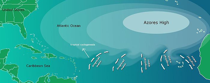 Tropical waves in the Atlantic basin develop from disturbances which develop as far east as Sudan
in east Africa
and drift over the continent into the Atlantic ocean
. These are generated or enhanced by the African Easterly Jet
. The clockwise circulation of the large transoceanic high-pressure cell or anticyclone
centered near the Azores
islands (known as the Azores High
) impels easterly waves away from the coastal areas of Africa towards North America
.
Approximately 60% of Atlantic tropical cyclones originate from tropical waves, while approximately 85% of intense Atlantic hurricanes (Category 3
and greater) develop from tropical waves.
Tropical cyclones can sometimes degenerate back into a tropical wave. This normally occurs if upper-level wind shear
is too strong. The storm can redevelop if the upper level shear abates.
If a tropical wave is moving quickly, it can have strong winds of over tropical storm force, but is not considered a tropical storm unless it has a closed circulation. An example of this was Hurricane Claudette
in 2003
, where the original wave had winds of 45 mi/h before developing a circulation.
tropical cyclones are formed out of tropical easterly waves that originate in North Africa
as well. During the summer months, tropical waves can extend northward as far as the desert southwest of the United States, producing spells of intensified shower activity embedded within the prevailing monsoon
regime.
is a weak cyclonic turning of low cloud forms. It can be detected on satellite imagery with such visual appearance below an upper level low.
Trough (meteorology)
A trough is an elongated region of relatively low atmospheric pressure, often associated with fronts.Unlike fronts, there is not a universal symbol for a trough on a weather chart. The weather charts in some countries or regions mark troughs by a line. In the United States, a trough may be marked...
, an elongated area of relatively low air pressure
Low pressure area
A low-pressure area, or "low", is a region where the atmospheric pressure at sea level is below that of surrounding locations. Low-pressure systems form under areas of wind divergence which occur in upper levels of the troposphere. The formation process of a low-pressure area is known as...
, oriented north
North
North is a noun, adjective, or adverb indicating direction or geography.North is one of the four cardinal directions or compass points. It is the opposite of south and is perpendicular to east and west.By convention, the top side of a map is north....
to south
South
South is a noun, adjective, or adverb indicating direction or geography.South is one of the four cardinal directions or compass points. It is the opposite of north and is perpendicular to east and west.By convention, the bottom side of a map is south....
, which move from east
East
East is a noun, adjective, or adverb indicating direction or geography.East is one of the four cardinal directions or compass points. It is the opposite of west and is perpendicular to north and south.By convention, the right side of a map is east....
to west
West
West is a noun, adjective, or adverb indicating direction or geography.West is one of the four cardinal directions or compass points. It is the opposite of east and is perpendicular to north and south.By convention, the left side of a map is west....
across the tropics
Tropics
The tropics is a region of the Earth surrounding the Equator. It is limited in latitude by the Tropic of Cancer in the northern hemisphere at approximately N and the Tropic of Capricorn in the southern hemisphere at S; these latitudes correspond to the axial tilt of the Earth...
causing areas of cloud
Cloud
A cloud is a visible mass of liquid droplets or frozen crystals made of water and/or various chemicals suspended in the atmosphere above the surface of a planetary body. They are also known as aerosols. Clouds in Earth's atmosphere are studied in the cloud physics branch of meteorology...
iness and thunderstorms. West-moving waves can also form from the tail end of frontal
Weather front
A weather front is a boundary separating two masses of air of different densities, and is the principal cause of meteorological phenomena. In surface weather analyses, fronts are depicted using various colored lines and symbols, depending on the type of front...
zones in the subtropics
Subtropics
The subtropics are the geographical and climatical zone of the Earth immediately north and south of the tropical zone, which is bounded by the Tropic of Cancer and the Tropic of Capricorn, at latitudes 23.5°N and 23.5°S...
and tropics and may be referred to as easterly waves, but these waves are not properly called tropical waves; they are a form of inverted trough sharing many characteristics with fully tropical waves. All tropical waves form in the easterly flow along the equatorward side of the subtropical ridge
Subtropical ridge
The subtropical ridge is a significant belt of high pressure situated around the latitudes of 30°N in the Northern Hemisphere and 30°S in the Southern Hemisphere. It is characterized by mostly calm winds, which acts to reduce air quality under its axis by causing fog overnight, and haze during...
or belt of high pressure
High pressure area
A high-pressure area is a region where the atmospheric pressure at the surface of the planet is greater than its surrounding environment. Winds within high-pressure areas flow outward due to the higher density air near their center and friction with land...
which lies north and south of the Intertropical Convergence Zone
Intertropical Convergence Zone
The Intertropical Convergence Zone , known by sailors as The Doldrums, is the area encircling the earth near the equator where winds originating in the northern and southern hemispheres come together....
(ITCZ). Tropical waves are generally carried westward by the prevailing easterly winds
Prevailing winds
Prevailing winds are winds that blow predominantly from a single general direction over a particular point on Earth's surface. The dominant winds are the trends in direction of wind with the highest speed over a particular point on the Earth's surface. A region's prevailing and dominant winds...
along the tropics and subtropics near the equator
Equator
An equator is the intersection of a sphere's surface with the plane perpendicular to the sphere's axis of rotation and containing the sphere's center of mass....
. They can lead to the formation of tropical cyclones in the north Atlantic and eastern north Pacific basins
Oceanic basin
Hydrologically, an oceanic basin may be anywhere on Earth that is covered by seawater, but geologically ocean basins are large geologic basins that are below sea level...
. Tropical wave study is aided by Hovmöller diagram
Hovmöller diagram
A Hovmöller diagram is a commonly used way of plotting meteorological data to highlight the role of waves. The axes of a Hovmöller diagram are typically longitude or latitude and time with the value of some field represented through color or shading...
s, a graph of meteorological data.
Characteristics
A tropical wave normally follows an area of sinking, intensely dry air, blowing from the northeast. After the passage of the trough line, the wind veers southeast, the humidity abruptly rises, and the atmosphere destabilizes. This yields widespread showers and thunderstorms, sometimes severe. As the wave moves westward, the showers gradually diminish.An exception to this rain is in the Atlantic. Sometimes, a surge of dry air called the Saharan Air Layer
Saharan Air Layer
The Saharan Air Layer is an intensely dry, warm and sometimes dust-laden layer of the atmosphere which often overlies the cooler, more-humid surface air of the Atlantic Ocean. In the Sahara Desert region of North Africa, where it originates, it is the prevalent atmosphere, extending from the...
(SAL) follows a tropical wave, leaving cloudless skies, as convection
Convection
Convection is the movement of molecules within fluids and rheids. It cannot take place in solids, since neither bulk current flows nor significant diffusion can take place in solids....
is capped by the dry layer inversion. Also, any dust in the SAL reflects sunlight, cooling the air below it.
Atlantic
Sudan
Sudan , officially the Republic of the Sudan , is a country in North Africa, sometimes considered part of the Middle East politically. It is bordered by Egypt to the north, the Red Sea to the northeast, Eritrea and Ethiopia to the east, South Sudan to the south, the Central African Republic to the...
in east Africa
Africa
Africa is the world's second largest and second most populous continent, after Asia. At about 30.2 million km² including adjacent islands, it covers 6% of the Earth's total surface area and 20.4% of the total land area...
and drift over the continent into the Atlantic ocean
Atlantic Ocean
The Atlantic Ocean is the second-largest of the world's oceanic divisions. With a total area of about , it covers approximately 20% of the Earth's surface and about 26% of its water surface area...
. These are generated or enhanced by the African Easterly Jet
African Easterly Jet
The African easterly jet, is a region of the lower troposphere over West Africa where the seasonal mean wind speed is maximum and easterly. Forming due to the temperature contrast between the Sahara and the Gulf of Guinea, maximum wind speeds are located at a height of to the north of the monsoon...
. The clockwise circulation of the large transoceanic high-pressure cell or anticyclone
Anticyclone
An anticyclone is a weather phenomenon defined by the United States' National Weather Service's glossary as "[a] large-scale circulation of winds around a central region of high atmospheric pressure, clockwise in the Northern Hemisphere, counterclockwise in the Southern Hemisphere"...
centered near the Azores
Azores
The Archipelago of the Azores is composed of nine volcanic islands situated in the middle of the North Atlantic Ocean, and is located about west from Lisbon and about east from the east coast of North America. The islands, and their economic exclusion zone, form the Autonomous Region of the...
islands (known as the Azores High
Azores High
The Azores High is a large subtropical semi-permanent centre of high atmospheric pressure found near the Azores in the Atlantic Ocean, at the Horse latitudes...
) impels easterly waves away from the coastal areas of Africa towards North America
North America
North America is a continent wholly within the Northern Hemisphere and almost wholly within the Western Hemisphere. It is also considered a northern subcontinent of the Americas...
.
Approximately 60% of Atlantic tropical cyclones originate from tropical waves, while approximately 85% of intense Atlantic hurricanes (Category 3
Saffir-Simpson Hurricane Scale
The Saffir–Simpson Hurricane Scale , or the Saffir–Simpson Hurricane Wind Scale , classifies hurricanes — Western Hemisphere tropical cyclones that exceed the intensities of tropical depressions and tropical storms — into five categories distinguished by the intensities of their sustained winds...
and greater) develop from tropical waves.
Tropical cyclones can sometimes degenerate back into a tropical wave. This normally occurs if upper-level wind shear
Wind shear
Wind shear, sometimes referred to as windshear or wind gradient, is a difference in wind speed and direction over a relatively short distance in the atmosphere...
is too strong. The storm can redevelop if the upper level shear abates.
If a tropical wave is moving quickly, it can have strong winds of over tropical storm force, but is not considered a tropical storm unless it has a closed circulation. An example of this was Hurricane Claudette
Hurricane Claudette (2003)
Hurricane Claudette was the third tropical storm and first hurricane of the 2003 Atlantic hurricane season. A fairly long-lived July Atlantic hurricane, Claudette began as a tropical wave in the eastern Caribbean. It moved quickly westward, brushing past the Yucatán Peninsula before moving...
in 2003
2003 Atlantic hurricane season
The 2003 Atlantic hurricane season was an active Atlantic hurricane season with tropical activity before and after the official bounds of the season – the first such occurrence in 50 years. The season produced 21 tropical cyclones, of which 16 developed into named storms; seven...
, where the original wave had winds of 45 mi/h before developing a circulation.
East Pacific
It has been suggested that some eastern Pacific OceanPacific Ocean
The Pacific Ocean is the largest of the Earth's oceanic divisions. It extends from the Arctic in the north to the Southern Ocean in the south, bounded by Asia and Australia in the west, and the Americas in the east.At 165.2 million square kilometres in area, this largest division of the World...
tropical cyclones are formed out of tropical easterly waves that originate in North Africa
North Africa
North Africa or Northern Africa is the northernmost region of the African continent, linked by the Sahara to Sub-Saharan Africa. Geopolitically, the United Nations definition of Northern Africa includes eight countries or territories; Algeria, Egypt, Libya, Morocco, South Sudan, Sudan, Tunisia, and...
as well. During the summer months, tropical waves can extend northward as far as the desert southwest of the United States, producing spells of intensified shower activity embedded within the prevailing monsoon
Monsoon
Monsoon is traditionally defined as a seasonal reversing wind accompanied by corresponding changes in precipitation, but is now used to describe seasonal changes in atmospheric circulation and precipitation associated with the asymmetric heating of land and sea...
regime.
Screaming eagle waves
A screaming eagle waveScreaming eagle (wave)
A screaming eagle is a tropical wave whose convective pattern has a strong resemblance to the head of an eagle. It is a tropical wave with active thunderstorm activity at its apex, which is sheared by either westerly winds aloft, or by strong easterly winds at the surface...
is a weak cyclonic turning of low cloud forms. It can be detected on satellite imagery with such visual appearance below an upper level low.
See also
- Hovmöller diagramHovmöller diagramA Hovmöller diagram is a commonly used way of plotting meteorological data to highlight the role of waves. The axes of a Hovmöller diagram are typically longitude or latitude and time with the value of some field represented through color or shading...
- Screaming eagle (wave)Screaming eagle (wave)A screaming eagle is a tropical wave whose convective pattern has a strong resemblance to the head of an eagle. It is a tropical wave with active thunderstorm activity at its apex, which is sheared by either westerly winds aloft, or by strong easterly winds at the surface...
- Tropical cycloneTropical cycloneA tropical cyclone is a storm system characterized by a large low-pressure center and numerous thunderstorms that produce strong winds and heavy rain. Tropical cyclones strengthen when water evaporated from the ocean is released as the saturated air rises, resulting in condensation of water vapor...
- Tropical cyclogenesisTropical cyclogenesisTropical cyclogenesis is the term that describes the development and strengthening of a tropical cyclone in the atmosphere. The mechanisms through which tropical cyclogenesis occurs are distinctly different from those through which mid-latitude cyclogenesis occurs...