
2004 Atlantic hurricane season
Encyclopedia
The 2004 Atlantic hurricane season officially began on June 1, 2004, and lasted until November 30, 2004. These dates conventionally delimit the period of each year when most tropical cyclone
s form in the Atlantic basin
. The 2004 season
exceeded these conventional limits slightly, as Tropical Storm Otto formed on the day before the last day of the season and lasted three days into December. Ironically, although a weak El Nino was emerging during the summer, the season was well above average in activity, with fifteen named storms and one of the highest Accumulated Cyclone Energy
totals ever observed.
Minus a very slow start, with the first storm forming almost two months after the season began, the season was highly active. A record 8 storms formed in the month of August, which ties a few other seasons with the amount of storms that formed in month, the majority of them in September, such as September 2007, which had 8 named storms. The season was unusual, in the fact that a weak El Nino was in place throughout the season, which hinted the late start, but the season was actually above average, even though historically El Nino limits the development of storms in the Atlantic basin.
The season was also notable as one of the deadliest and most costly Atlantic hurricane seasons on record in the last decade, with at least 3,132 deaths and roughly $50 billion (2004 USD; $ USD) in damage. The most notable storms for the season were the five named storms that made landfall in the U.S. state
of Florida
, three of them with at least 115 mph (185 km/h) sustained winds: Hurricanes Charley
, Frances
, Ivan
, and Jeanne
, and Tropical Storm Bonnie
. This is the only time in recorded history that four hurricanes affected Florida. Jeanne
wreaked havoc in Haiti
, killing more than 3,000 people, and was the deadliest tropical cyclone since Mitch
in 1998. Ivan raged through Grenada
, Jamaica
, and the Cayman Islands
, while Frances and Jeanne both hit the Bahamas at full force. Charley, a small hurricane, caused significant damage in Cuba
. Floodwaters in the southeastern United States
from many of the hurricanes in 2004 brought to near-record levels.
On May 17, prior to the start of the season, NOAA
forecasters predicted a 50% probability of activity above the normal range, with 12–15 tropical storms, 6–8 of those becoming hurricanes, and 2–4 of those hurricanes reaching at least Category 3 strength on the Saffir-Simpson Hurricane Scale
. Noted hurricane expert Dr. William Gray
's May 28 prediction was similar, with 14 named storms, 8 reaching hurricane strength, and 3 reaching Category 3 strength.
On August 6, Dr. Gray announced he had revised his predictions slightly downwards, citing mild El Niño conditions, to 13 named storms, 7 hurricanes, and 3 reaching Category 3. Several days later, NOAA released an updated prediction as well, with a 90% probability of above-to-near normal activity, but the same number of storms forecast. A normal season, as defined by NOAA, has 6 to 14 tropical storms, 4 to 8 of which reach hurricane strength, and 1 to 3 of those reaching Category 3 strength. The season ended up with 16 tropical depressions, 15 named storms, 9 hurricanes, and six major hurricanes, placing it above all forecasts.

). The Accumulated Cyclone Energy
figure of 225 ranks this as the fourth most active season since 1950 (behind the 2005 season
, the 1950 season
and the 1995 season
).
August 2004 was active, with eight named storms forming during the month despite a weak El Niño emerging during the summer. In an average year, only three or four storms would be named in August. The formation of eight named storms in August breaks the old record of seven for the month, set in the 1933
and 1995 seasons. It also ties with September in the 2002
, 2007
and the 2010
seasons for the most Atlantic tropical storms to form in any month.
The season's activity was reflected with a high cumulative accumulated cyclone energy
(ACE) rating of 227. ACE is, broadly speaking, a measure of the power of the hurricane multiplied by the length of time it existed, so storms that last a long time, as well as particularly strong hurricanes, have high ACEs. ACE is only calculated for full advisories on tropical systems at or exceeding 34 knots (39 mph, 63 km/h) or tropical storm strength. Subtropical cyclone
s, such as Nicole
or the early portion of Otto's track, are excluded from the total.
 The 2004 season was very deadly, with over 3,000 deaths related to the flooding rains or winds caused by the storms. Nearly all of the deaths were reported in Haiti following the floods and mudslides caused by then-Tropical Storm Jeanne.
A tropical low in May brought torrential flooding to Haiti
and the Dominican Republic
, killing 2,000 people and causing great damage. Though it was not officially classified as a tropical storm, it did have a circulation with loosely organized convection, resembling a subtropical cyclone
.
Damage from the 2004 Atlantic hurricane season was estimated at around $50 billion (2004 USD; $ USD), over half of which was caused by Hurricanes Charley and Ivan. These two hurricanes caused $16 billion (2004 USD; $ USD) and $17.2 billion (2004 USD; $ USD) in damage, respectively. While damage estimates from Hurricanes Frances and Jeanne amounted to $9.6 billion (2004 USD; $ USD) and $7 billion (2004 USD; $ USD), respectively. The cause of the devastating effects was due to the strength and the fact that all of the four costliest hurricanes of the 2004 season made several landfalls. Despite the season being very costly, it is a distant second to the 2005 Atlantic hurricane season, which resulted in $128 billion (2005 USD; $ USD).
The 2004 season had numerous unusual occurrences. The first named storm of the season formed on August 1, giving the season the fifth-latest start since the 1952 season
. Florida was hit by four hurricanes: Hurricane Charley
, Frances
, Ivan
, and Jeanne
. It was the first time four hurricanes have hit one state in one season since four hurricanes hit the Texas
coast in the 1886 season
, including the Indianola Hurricane of 1886
that destroyed the city of Indianola
. There were many other hurricanes in the 2004 Atlantic hurricane season that were individually unusual. Hurricane Alex
was the strongest hurricane on record to intensify north of 38°N latitude. One storm, Tropical Storm Earl, died out, and its remains crossed over into the Pacific Ocean
, regenerated, and became Hurricane Frank in the eastern Pacific.
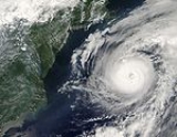
The most unusual storm of the season was Hurricane Ivan
. Ivan first became the first major Atlantic hurricane (Category 3 or above) on record to form as low as 10°N latitude. Ivan was also recorded as the sixth most intense Atlantic hurricane on record up to that point (since pushed down to tenth), with a minimum central pressure of 910 mbar (hPa
). One very unusual occurrence in relation to Ivan happened on September 22, when a remnant low
from Ivan—which had traveled in a circular motion over the southeastern United States—was reclassified as a tropical depression as it moved over the Gulf of Mexico
. The system was given the name Ivan and eventually strengthened into a tropical storm with winds of 65 mph (100 km/h) before making landfall along the coast of Texas
, causing minimal flooding and damage.
moved over land. As it moved out to sea, it initially weakened, although it re-intensified over the Gulf Stream to reach major hurricane status and peak winds of 120 mph (195 km/h); located 450 mi (710 km) south of Halifax, Nova Scotia
, Alex reached major hurricane status further north than any other Atlantic hurricane but one. After passing south of Newfoundland, the hurricane quickly weakened due to cooler waters, and late on August 6 Alex was absorbed by a large extratropical cyclone
.
The hurricane produced light damage in the Outer Banks
, primarily from flooding and high winds. Over 100 houses were damaged, and numerous cars were disabled from the flooding. Damage totaled about $7.5 million (2004 USD, $ USD). Alex produced strong waves and rip tides along the East Coast of the United States
, causing one death and several injuries.
from a tropical wave on August 3, although it quickly lost its low-level circulation
. The system continued westward, reforming into a tropical depression in the northwestern Caribbean Sea on August 8. Across the region, its effects consisted primarily of light rainfall. On August 9 the depression intensified into Tropical Storm Bonnie in the Gulf of Mexico, subsequently turning northeastward and reaching peak winds of 65 mph (100 km/h). Despite only being a tropical storm, Bonnie briefly developed a small eyewall
.
Strong wind shear caused weakening, and Bonnie made landfall just south of Apalachicola, Florida
as a minimal tropical storm at 1400 UTC
on August 12. In the state, the storm caused flood
ing and minor beach erosion. While weakening across the southeastern United States, the storm produced a tornado outbreak that killed three people in North Carolina and left damage of over $1 million (2004 USD, $ USD). The cyclone degenerated into a remnant low
, which subsequently entered Atlantic Canada
. In New Brunswick
, slick rains from the remnants of Bonnie caused an indirect fatality.
from a tropical wave. It quickly moved through the Caribbean Sea, encountering favorable conditions that allowed intensification into Tropical Storm and later Hurricane Charley. After passing near Jamaica
, the Cayman Islands
, and the Isle of Youth
, the hurricane turned northward and crossed central Cuba
as a Category 3 on the Saffir-Simpson Hurricane Scale. Charley briefly weakened over land before accelerating toward southwestern Florida, influenced by an unseasonably strong trough
. With a small overall size, it rapidly intensified on August 13 to attain peak winds of 150 mph (240 km/h) – Category 4 status – at which strength the hurricane struck Cayo Costa
. Shortly thereafter, Charley made landfall on Punta Gorda
, becoming the strongest tropical cyclone to hit the United States since Hurricane Andrew
. It brought strong winds across the state, and weakened significantly before emerging into the Atlantic Ocean and striking South Carolina
. Charley became extratropical on August 15 near Virginia Beach, Virginia
, and it later was absorbed by a cold front
.
Charley caused approximately $14 billion (2004 USD, $ USD) in damage to the United States, making it the fourth costliest hurricane in U.S. history, and the second costliest at the time. Although the storm caused serious damage, much of this was limited to a narrow swath associated with the hurricane's eye wall. Charley was a very fast-moving, compact storm, and so much of its damage was attributed to high winds rather than heavy rain. Fifteen deaths were directly attributed to Charley; four in Jamaica
, one in Cuba
, and ten in Florida.
. It was the first of five Cape Verde-type hurricane
s of 2004. Twelve hours later, Tropical Depression Four strengthened and was named Tropical Storm Danielle. Late on August 14, Danielle's wind speeds increased, and it was classified as a hurricane. Danielle moved northwest, peaking at Category 2 hurricane. It was predicted to curve towards the Azores
, but curved westward on August 18 and weakened to a tropical storm. By August 19, the storm had become stationary with minimal storm strength 810 miles (1305 km) southwest of the Azores. The storm was downgraded to a tropical depression the next day, and degenerated to a broad low-pressure area on August 21. The remnants of Danielle moved to the west and ultimately to the northwest.
. After traveling west, it reached tropical storm strength on August 14 around 375 miles (605 km) southeast of Barbados
. On August 15, Earl passed just south of Grenada and entered the Caribbean. The storm had degenerated by that point, and that night would have been classified as a tropical wave. However, the government of Venezuela
denied access to their airspace for storm reconnaissance
aircraft. An on-site assessment of Earl's circulation was needed, since satellite observations are inaccurate for that purpose. Earl also posed a threat to land, so advisories continued for another 12 hours.
The next morning a reconnaissance aircraft was able to reach the storm. It found no closed circulation, and Earl was reclassified as a tropical wave on August 16. Remnants of the storm continued across the Caribbean and into Central America
, later becoming Tropical Depression Eight-E and then Hurricane Frank in the Pacific Ocean
. Earl caused minor damage to Grenada and St. Vincent and the Grenadines.
. Frances strengthened rapidly, reaching Category 4 intensity by August 27. Initially forecast to turn north and potentially threaten Bermuda
, conditions changed and Frances's predicted track shifted westward. After grazing the Turks and Caicos Islands
, it plowed through the Bahamas. From September 2 through September 4, Frances slowly ground its way across the Bahamas. Its slow movement allowed a record 2.5 to 3 million Floridians to evacuate their homes. However, as it ground its way across the Bahamas, it weakened to a Category 2 hurricane due to wind shear, although it was still a very large storm.
After sitting stationary off the coast of Florida for nearly 24 hours, Frances finally moved onto the coast of Florida in the early hours of September 5. It traveled northwest over land, briefly emerging over the Gulf of Mexico and striking the Florida Panhandle
. As it passed over Georgia
on September 6, it caused heavy rainfall across the southern United States. Over 15 inches (381 mm) of rain were recorded in some places in North Carolina and Virginia
, causing heavy flooding. Frances was downgraded to a tropical depression and dissipated over Pennsylvania
on September 9.
Damage to the United States was approximately $9 billion (2004 USD, $ USD), making it the tenth costliest hurricane in U.S. history. Most of Hurricane Frances's damage occurred in Florida as a result of the storm's slow movement, large size, and long duration of winds. The storm is directly responsible for seven deaths; one in the Bahamas and six in the United States
. Hurricane Frances also produced 103 tornadoes as it moved its way through the United States.
. The depression meandered off the coast for the rest of the day, strengthening into Tropical Storm Gaston by midday August 28.
At 10 a.m. EDT (1400 UTC) on August 29, Gaston made landfall on the coast of Bulls Bay, South Carolina, near the towns of McClellanville
and Awendaw
. It was downgraded to a tropical depression later that day. The storm made landfall in almost the same location as Hurricane Hugo
in 1989.
At landfall the storm was originally classified as just shy of hurricane strength. While wind damage in South Carolina was minimal, the slow-moving storm produced five to ten inches (125 to 250 mm) of rain along its path, causing extensive flooding. Gaston moved north over land, weakening to a tropical depression but still bringing torrential rain to central Virginia
, where at least eight people were killed in the ensuing floods. The Shockoe Bottom
entertainment district near downtown Richmond
was devastated by the flooding. Total damage was estimated at about $130 million.
Late on August 30, as Tropical Depression Gaston crossed Chesapeake Bay
, its winds strengthened, and it was again classified as a tropical storm. It headed out over the Atlantic and became extratropical on September 1, about 185 miles (300 km) southeast of Halifax, Nova Scotia
.
On November 19, after a detailed analysis by the NHC, surface-level winds were determined to be about 75 mph (120 km/h) at landfall, and Gaston was reclassified as a Category 1 hurricane.
, and moved rapidly north towards Cape Cod
. On its northward trek, Hermine left behind most of its convection. The storm made landfall near New Bedford, Massachusetts
, early on August 31, appearing as little more than a low-level swirl of clouds. It became extratropical a few hours later. The remnant low centre tracked up the Bay of Fundy later on August 31. Some rainfall and thunderstorms over Long Island
and parts of New England
were attributed to Hermine, but most people did not realize a tropical storm had struck.
There were no casualties or reports of major damage caused by Hermine. Locally heavy rain did fall in portions of southern New Brunswick
, which received 1.6 to 2.2 in (40.6 to 55.9 mm). Minor basement flooding and street closures were also reported in Moncton, New Brunswick.
that began as Tropical Depression Nine on September 2. It became a tropical storm on September 3, and a hurricane on September 5 while 1,040 miles (1670 km) east of the Windward Islands, at 9.9° N. Later that day, while at 10.6° N, Ivan unexpectedly began to rapidly strengthening, and reached Category 4 intensity by that evening. It was the strongest storm to have ever been known to intensify that far south. Ivan weakened slightly while continuing westward, and struck Grenada
on September 7.
While moving westward through the Caribbean Sea
, Ivan quickly intensified to a Category 5 hurricane. It fluctuated in strength over the next few days, and passed within 30 miles (50 km) of Grand Cayman
on September 11. Ivan grazed western Cuba
as a Category 5, and moved into the Gulf of Mexico. The hurricane turned northward over cooler waters, and made landfall in southern Alabama
on September 16 as a 120 mph (195 km/h) hurricane. Ivan weakened rapidly to a tropical depression over Alabama, accelerated to the northeast, and became extratropical over the Delmarva Peninsula
on September 18. Ivan's remnants turned to the southeast then southwest, and gradually re-organized over the warm Gulf Stream waters. After crossing southern Florida
on September 21 the system regained tropical characteristics over the Gulf of Mexico, and became a tropical storm on September 23 while 140 miles (220 km) south of Louisiana
. Ivan moved to the northwest, and reached winds of 60 mph (95 km/h) before making landfall near Cameron, Louisiana
. Ivan quickly deteriorated over Texas
, and dissipated on September 24.
Hurricane Ivan directly killed 92 people throughout the Caribbean and United States and caused approximately $13 billion in damage to the United States, making it the fifth costliest hurricane in United States history. The hurricane destroyed 90% of Grenada's structures and devastated the island's economy, and destroyed 85% of the buildings on Grand Cayman. The combination of Hurricane Ivan with the previous rains of Frances brought many rivers in the Southeastern U.S. to near-record flood levels. Ivan was the strongest storm of the season, and the only 2004 Atlantic hurricane to reach Category 5 intensity. Its low pressure reading of 910 mbar (26.9 inHg) made it the sixth most intense Atlantic hurricane on record at the time.
on August 30, and over the next week moved to the northwest, north, and eventually to the northeast. On September 7 a low-level circulation formed, and the system became a tropical depression; at the time, convection was displaced to the northeast of the center due to upper-level wind shear. Advisories were not issued until two days later. The depression failed to intensify significantly, only reaching a peak of 35 mph (56.3 km/h) and a minimum pressure was 1009 mbar. Some tropical cyclone advisories stated that there was a small possibility for Tropical Depression Ten to become a tropical storm, though it was not forecast to do so. On September 9, wind shear displaced the deep convection from the center, and the NHC issued the final advisory on September 10 after the depression became devoid of almost any convection. At the time, it was located about 380 mi (610 km) west-southwest of the Azores. The remnant low headed generally south-southeastward, remaining to the south of the Azores before dissipating on September 10. There were no reports of damage or casualties.
on the evening of September 13. Having strengthened to a tropical storm, Jeanne crossed Puerto Rico
on September 15. It then moved toward Hispaniola
, barely reaching hurricane strength before making landfall on September 16. It tracked slowly across the northern coast of the Dominican Republic
and Haiti
, its heavy rains bringing mudslides and flooding. Jeanne's unusually slow journey was actually caused by a weakening Hurricane Ivan. Ivan broke up a trough that was fuelling Jeanne's steering currents. Interaction with Hispaniola caused it to degenerate into a tropical depression.
After wreaking havoc on Hispaniola, Jeanne struggled to reorganize. However, it eventually began strengthening and headed north. After performing a complete loop over the open Atlantic, it headed westwards, strengthening into a Category 3 hurricane and passing over the islands of Great Abaco and Grand Bahama
in the Bahamas on September 25. Jeanne made landfall later in the day near Stuart, Florida just 2 miles (3 kilometers) from where Frances had struck 3 weeks earlier. Building on the rainfall of Frances
and Ivan
, Jeanne brought near-record flood levels as far north as West Virginia
and New Jersey
before its remnants turned east into the open Atlantic.
Jeanne is blamed for at least 3,006 deaths in Haiti
with about 2,800 in Gonaïves
alone, which was nearly washed away by floods and mudslides. The storm also caused 7 deaths in Puerto Rico
, 18 in the Dominican Republic
and at least 4 in Florida
, bringing the total number of deaths to at least 3,025. Final property damage in the United States was $6.8 billion, making this the 13th costliest hurricane in U.S. history.
islands on September 16. It became Tropical Storm Karl at 11 p.m. AST (0300 UTC) that day. Early on September 18, it strengthened rapidly to become a hurricane and was a major hurricane later that day.
Karl continued strengthening and became a 145 mph (230 km/h) Category 4 hurricane on September 21. It fluctuated in intensity over the next few days, reaching Category 4 strength on two different occasions. It moved steadily northwards, staying hundreds of miles from any land, until it began to weaken and become extratropical over cooler waters. Karl was still of Category 1 strength when it became an extratropical system on September 24 over the northern Atlantic at about 47° N. The extratropical system struck the Faroe Islands
two days later with 144 km/h (89 mph) wind gusts.
islands on September 19. It became Tropical Storm Lisa at 8 a.m. AST on September 20 with maximum sustained winds of 50 mph (80 km/h). A very small storm, its development was hindered by its proximity to Hurricane Karl. On September 22, Lisa began merging with a large tropical disturbance to its east and weakened to a tropical depression for a couple of days before regaining tropical storm strength on September 25. By then it was heading generally northwards in the mid-Atlantic. Lisa went through several phases of weakening and strengthening as it headed north, finally reaching hurricane strength on October 1, and again the next day.
Lisa was a hurricane only briefly, moving over cooler waters and weakening to a tropical storm. It became extratropical early on October 3 while located about 475 miles (760 km) north-northwest of the Azores
. It never threatened any land area. Lisa's total development time from tropical depression to hurricane, at 12½ days, is the second longest period for an Atlantic tropical cyclone
to reach hurricane strength, only to Hurricane Josephine of 1990
.
, and Arkansas
.
On the afternoon of October 8, the low pressure system developed into Tropical Storm Matthew 260 miles (420 km) east-southeast of Brownsville, Texas
. Matthew was a minimal tropical storm, and its sustained winds stayed at or near 40 mph (64 km/h) from its naming until landfall on October 10. It became extratropical inland over Louisiana
later in the day, and dissipated when it was near El Dorado, Arkansas
.
Matthew brought up to 12 inches (300 mm) of rain to southern Louisiana. About a dozen homes were flooded in Terrebonne Parish
after a canal
levee
burst, and streets in St. Bernard Parish
were reportedly under 2 feet (60 cm) of water. The remnants of Matthew continued to spin inland and delivered heavy rainfall for at least five more days. No injuries or deaths were reported.
After passing Bermuda, Nicole developed an area of convection near the center, suggesting the beginning of a transition to a tropical cyclone. However, strong wind shear
caused weakening after the storm reached peak winds of 50 mph (85 km/h). A larger extratropical storm absorbed Nicole on October 11 to the south of Nova Scotia. The combination of the two storms produced flooding rains and gusty winds across Atlantic Canada. Since 2002, subtropical storms
have been assigned names from the same sequence as tropical storms. Nicole was the first named storm under this policy that never achieved tropical status.
in 2004. The names not retired from this list will be used again in the 2010 season
. This is the same list used for the 1998 season
except for Gaston and Matthew, which replaced Georges
and Mitch
. Storms were named Gaston, Matthew, and Otto for the first time in 2004. Names that were not assigned are marked in .
retired four names in the spring of 2005: Charley, Frances, Ivan, and Jeanne. They were replaced in 2010 by Colin, Fiona, Igor, and Julia. The 2004 season was tied with the 1955 season
and 1995 season
for the most storm names retired after a single season until the 2005 season
, when five names were retired.
Tropical cyclone
A tropical cyclone is a storm system characterized by a large low-pressure center and numerous thunderstorms that produce strong winds and heavy rain. Tropical cyclones strengthen when water evaporated from the ocean is released as the saturated air rises, resulting in condensation of water vapor...
s form in the Atlantic basin
Atlantic Basin
The Atlantic Basin is the Atlantic Ocean.Atlantic Basin may also refer to:* Atlantic Basin Iron Works, an ironworks that operated in Brooklyn, New York, in the early to mid-20th century...
. The 2004 season
Atlantic hurricane season
The Atlantic hurricane season is the period in a year when hurricanes usually form in the Atlantic Ocean. Tropical cyclones in the North Atlantic are called hurricanes, tropical storms, or tropical depressions. In addition, there have been several storms over the years that have not been fully...
exceeded these conventional limits slightly, as Tropical Storm Otto formed on the day before the last day of the season and lasted three days into December. Ironically, although a weak El Nino was emerging during the summer, the season was well above average in activity, with fifteen named storms and one of the highest Accumulated Cyclone Energy
Accumulated cyclone energy
Accumulated cyclone energy is a measure used by the National Oceanic and Atmospheric Administration to express the activity of individual tropical cyclones and entire tropical cyclone seasons, particularly the North Atlantic hurricane season. It uses an approximation of the energy used by a...
totals ever observed.
Minus a very slow start, with the first storm forming almost two months after the season began, the season was highly active. A record 8 storms formed in the month of August, which ties a few other seasons with the amount of storms that formed in month, the majority of them in September, such as September 2007, which had 8 named storms. The season was unusual, in the fact that a weak El Nino was in place throughout the season, which hinted the late start, but the season was actually above average, even though historically El Nino limits the development of storms in the Atlantic basin.
The season was also notable as one of the deadliest and most costly Atlantic hurricane seasons on record in the last decade, with at least 3,132 deaths and roughly $50 billion (2004 USD; $ USD) in damage. The most notable storms for the season were the five named storms that made landfall in the U.S. state
U.S. state
A U.S. state is any one of the 50 federated states of the United States of America that share sovereignty with the federal government. Because of this shared sovereignty, an American is a citizen both of the federal entity and of his or her state of domicile. Four states use the official title of...
of Florida
Florida
Florida is a state in the southeastern United States, located on the nation's Atlantic and Gulf coasts. It is bordered to the west by the Gulf of Mexico, to the north by Alabama and Georgia and to the east by the Atlantic Ocean. With a population of 18,801,310 as measured by the 2010 census, it...
, three of them with at least 115 mph (185 km/h) sustained winds: Hurricanes Charley
Hurricane Charley
Hurricane Charley was the third named storm, the second hurricane, and the second major hurricane of the 2004 Atlantic hurricane season. Charley lasted from August 9 to August 15, and at its peak intensity it attained 150 mph winds, making it a strong Category 4 hurricane on the...
, Frances
Hurricane Frances
Hurricane Frances was the sixth named storm, the fourth hurricane, and the third major hurricane of the 2004 Atlantic hurricane season. The system crossing the open Atlantic during mid to late August, moving to the north of the Lesser Antilles while strengthening. Its outer bands affected Puerto...
, Ivan
Hurricane Ivan
Hurricane Ivan was a large, long-lived, Cape Verde-type hurricane that caused widespread damage in the Caribbean and United States. The cyclone was the ninth named storm, the sixth hurricane and the fourth major hurricane of the active 2004 Atlantic hurricane season...
, and Jeanne
Hurricane Jeanne
Hurricane Jeanne was the deadliest hurricane in the 2004 Atlantic hurricane season. It was the tenth named storm, the seventh hurricane, and the fifth major hurricane of the season, as well as the third hurricane and fourth named storm of the season to make landfall in Florida...
, and Tropical Storm Bonnie
Tropical Storm Bonnie (2004)
Tropical Storm Bonnie was a small tropical storm that made landfall on Florida in August 2004. The second storm of the 2004 Atlantic hurricane season, Bonnie developed from a tropical wave on August 3 to the east of the Lesser Antilles. After moving through the islands, its fast forward motion...
. This is the only time in recorded history that four hurricanes affected Florida. Jeanne
Hurricane Jeanne
Hurricane Jeanne was the deadliest hurricane in the 2004 Atlantic hurricane season. It was the tenth named storm, the seventh hurricane, and the fifth major hurricane of the season, as well as the third hurricane and fourth named storm of the season to make landfall in Florida...
wreaked havoc in Haiti
Haiti
Haiti , officially the Republic of Haiti , is a Caribbean country. It occupies the western, smaller portion of the island of Hispaniola, in the Greater Antillean archipelago, which it shares with the Dominican Republic. Ayiti was the indigenous Taíno or Amerindian name for the island...
, killing more than 3,000 people, and was the deadliest tropical cyclone since Mitch
Hurricane Mitch
Hurricane Mitch was the most powerful hurricane and the most destructive of the 1998 Atlantic hurricane season, with maximum sustained winds of 180 mph . The storm was the thirteenth tropical storm, ninth hurricane, and third major hurricane of the season. Along with Hurricane Georges, Mitch...
in 1998. Ivan raged through Grenada
Grenada
Grenada is an island country and Commonwealth Realm consisting of the island of Grenada and six smaller islands at the southern end of the Grenadines in the southeastern Caribbean Sea...
, Jamaica
Jamaica
Jamaica is an island nation of the Greater Antilles, in length, up to in width and 10,990 square kilometres in area. It is situated in the Caribbean Sea, about south of Cuba, and west of Hispaniola, the island harbouring the nation-states Haiti and the Dominican Republic...
, and the Cayman Islands
Cayman Islands
The Cayman Islands is a British Overseas Territory and overseas territory of the European Union located in the western Caribbean Sea. The territory comprises the three islands of Grand Cayman, Cayman Brac, and Little Cayman, located south of Cuba and northwest of Jamaica...
, while Frances and Jeanne both hit the Bahamas at full force. Charley, a small hurricane, caused significant damage in Cuba
Cuba
The Republic of Cuba is an island nation in the Caribbean. The nation of Cuba consists of the main island of Cuba, the Isla de la Juventud, and several archipelagos. Havana is the largest city in Cuba and the country's capital. Santiago de Cuba is the second largest city...
. Floodwaters in the southeastern United States
Southeastern United States
The Southeastern United States, colloquially referred to as the Southeast, is the eastern portion of the Southern United States. It is one of the most populous regions in the United States of America....
from many of the hurricanes in 2004 brought to near-record levels.
Seasonal forecasts
| Source | Date | Tropical storms |
Hurricanes | Major hurricanes |
| CSU Colorado State University Colorado State University is a public research university located in Fort Collins, Colorado. The university is the state's land grant university, and the flagship university of the Colorado State University System.The enrollment is approximately 29,932 students, including resident and... |
Average (1950–2000) | 9.6 | 5.9 | 2.3 |
| NOAA National Oceanic and Atmospheric Administration The National Oceanic and Atmospheric Administration , pronounced , like "noah", is a scientific agency within the United States Department of Commerce focused on the conditions of the oceans and the atmosphere... |
Average | 11 | 6 | 2 |
| NOAA | May 17, 2004 | 12–15 | 6–8 | 2–4 |
| CSU | May 28, 2004 | 14 | 8 | 3 |
| CSU | August 6, 2004 | 13 | 7 | 3 |
| Actual activity | 15 | 9 | 6 | |
On May 17, prior to the start of the season, NOAA
National Oceanic and Atmospheric Administration
The National Oceanic and Atmospheric Administration , pronounced , like "noah", is a scientific agency within the United States Department of Commerce focused on the conditions of the oceans and the atmosphere...
forecasters predicted a 50% probability of activity above the normal range, with 12–15 tropical storms, 6–8 of those becoming hurricanes, and 2–4 of those hurricanes reaching at least Category 3 strength on the Saffir-Simpson Hurricane Scale
Saffir-Simpson Hurricane Scale
The Saffir–Simpson Hurricane Scale , or the Saffir–Simpson Hurricane Wind Scale , classifies hurricanes — Western Hemisphere tropical cyclones that exceed the intensities of tropical depressions and tropical storms — into five categories distinguished by the intensities of their sustained winds...
. Noted hurricane expert Dr. William Gray
William M. Gray
William M. "Bill" Gray is Emeritus Professor of Atmospheric Science at Colorado State University , and head of the Tropical Meteorology Project at CSU's Department of Atmospheric Sciences. He is a pioneer in the science of forecasting hurricanes and one of the world's leading experts on tropical...
's May 28 prediction was similar, with 14 named storms, 8 reaching hurricane strength, and 3 reaching Category 3 strength.
On August 6, Dr. Gray announced he had revised his predictions slightly downwards, citing mild El Niño conditions, to 13 named storms, 7 hurricanes, and 3 reaching Category 3. Several days later, NOAA released an updated prediction as well, with a 90% probability of above-to-near normal activity, but the same number of storms forecast. A normal season, as defined by NOAA, has 6 to 14 tropical storms, 4 to 8 of which reach hurricane strength, and 1 to 3 of those reaching Category 3 strength. The season ended up with 16 tropical depressions, 15 named storms, 9 hurricanes, and six major hurricanes, placing it above all forecasts.
Seasonal summary
This season had 16 tropical depressions, 15 named storms, nine hurricanes, and six major hurricanes (Category 3 or higher on the Saffir-Simpson Hurricane ScaleSaffir-Simpson Hurricane Scale
The Saffir–Simpson Hurricane Scale , or the Saffir–Simpson Hurricane Wind Scale , classifies hurricanes — Western Hemisphere tropical cyclones that exceed the intensities of tropical depressions and tropical storms — into five categories distinguished by the intensities of their sustained winds...
). The Accumulated Cyclone Energy
Accumulated cyclone energy
Accumulated cyclone energy is a measure used by the National Oceanic and Atmospheric Administration to express the activity of individual tropical cyclones and entire tropical cyclone seasons, particularly the North Atlantic hurricane season. It uses an approximation of the energy used by a...
figure of 225 ranks this as the fourth most active season since 1950 (behind the 2005 season
2005 Atlantic hurricane season
The 2005 Atlantic hurricane season was the most active Atlantic hurricane season in recorded history, repeatedly shattering numerous records. The impact of the season was widespread and ruinous with an estimated 3,913 deaths and record damage of about $159.2 billion...
, the 1950 season
1950 Atlantic hurricane season
The 1950 Atlantic hurricane season was the first year in which tropical cyclones were given official names in the Atlantic basin. Names were taken from the Joint Army/Navy Phonetic Alphabet, with the first named storm being designated "Able", the second "Baker", and so on. It was an active season...
and the 1995 season
1995 Atlantic hurricane season
The 1995 Atlantic hurricane season was the third most active Atlantic hurricane season on record. It officially began on June 1, 1995, and lasted until November 30, 1995. These dates conventionally delimit the period of each year when most tropical cyclones form in the north Atlantic ocean...
).
August 2004 was active, with eight named storms forming during the month despite a weak El Niño emerging during the summer. In an average year, only three or four storms would be named in August. The formation of eight named storms in August breaks the old record of seven for the month, set in the 1933
1933 Atlantic hurricane season
The 1933 Atlantic hurricane season was the second most active Atlantic hurricane season on record, with 21 storms forming during that year in the northwest Atlantic Ocean. The season ran through the summer and the first half of fall in 1933, and was surpassed in total number of tropical cyclones by...
and 1995 seasons. It also ties with September in the 2002
2002 Atlantic hurricane season
The 2002 Atlantic hurricane season was an average Atlantic hurricane season, officially starting on June 1, 2002 and ending on November 30, dates which conventionally limit the period of each year when tropical cyclones in the Atlantic Ocean tend to form...
, 2007
2007 Atlantic hurricane season
The 2007 Atlantic hurricane season was an active Atlantic hurricane season that produced 17 tropical cyclones, 15 tropical storms, six hurricanes, and two major hurricanes. It officially started on June 1 and ended on November 30, dates which conventionally delimit the...
and the 2010
2010 Atlantic hurricane season
The 2010 Atlantic hurricane season was the third most active Atlantic hurricane season on record, tying with the 1887 Atlantic hurricane season, 1995 Atlantic hurricane season and the 2011 Atlantic hurricane season. It had the most number of named storms since the 2005 season and also ties with the...
seasons for the most Atlantic tropical storms to form in any month.
The season's activity was reflected with a high cumulative accumulated cyclone energy
Accumulated cyclone energy
Accumulated cyclone energy is a measure used by the National Oceanic and Atmospheric Administration to express the activity of individual tropical cyclones and entire tropical cyclone seasons, particularly the North Atlantic hurricane season. It uses an approximation of the energy used by a...
(ACE) rating of 227. ACE is, broadly speaking, a measure of the power of the hurricane multiplied by the length of time it existed, so storms that last a long time, as well as particularly strong hurricanes, have high ACEs. ACE is only calculated for full advisories on tropical systems at or exceeding 34 knots (39 mph, 63 km/h) or tropical storm strength. Subtropical cyclone
Subtropical cyclone
A subtropical cyclone is a weather system that has some characteristics of a tropical and an extratropical cyclone. As early as the 1950s, meteorologists were unclear whether they should be characterized as tropical or extratropical cyclones. They were officially recognized by the National...
s, such as Nicole
Subtropical Storm Nicole (2004)
Subtropical Storm Nicole was the first subtropical storm to receive a name using the standard hurricane name list that did not become a tropical cyclone. The fourteenth tropical or subtropical storm of the 2004 Atlantic hurricane season, Nicole developed on October 10 near Bermuda from the...
or the early portion of Otto's track, are excluded from the total.
A tropical low in May brought torrential flooding to Haiti
Haiti
Haiti , officially the Republic of Haiti , is a Caribbean country. It occupies the western, smaller portion of the island of Hispaniola, in the Greater Antillean archipelago, which it shares with the Dominican Republic. Ayiti was the indigenous Taíno or Amerindian name for the island...
and the Dominican Republic
Dominican Republic
The Dominican Republic is a nation on the island of La Hispaniola, part of the Greater Antilles archipelago in the Caribbean region. The western third of the island is occupied by the nation of Haiti, making Hispaniola one of two Caribbean islands that are shared by two countries...
, killing 2,000 people and causing great damage. Though it was not officially classified as a tropical storm, it did have a circulation with loosely organized convection, resembling a subtropical cyclone
Subtropical cyclone
A subtropical cyclone is a weather system that has some characteristics of a tropical and an extratropical cyclone. As early as the 1950s, meteorologists were unclear whether they should be characterized as tropical or extratropical cyclones. They were officially recognized by the National...
.
Damage from the 2004 Atlantic hurricane season was estimated at around $50 billion (2004 USD; $ USD), over half of which was caused by Hurricanes Charley and Ivan. These two hurricanes caused $16 billion (2004 USD; $ USD) and $17.2 billion (2004 USD; $ USD) in damage, respectively. While damage estimates from Hurricanes Frances and Jeanne amounted to $9.6 billion (2004 USD; $ USD) and $7 billion (2004 USD; $ USD), respectively. The cause of the devastating effects was due to the strength and the fact that all of the four costliest hurricanes of the 2004 season made several landfalls. Despite the season being very costly, it is a distant second to the 2005 Atlantic hurricane season, which resulted in $128 billion (2005 USD; $ USD).
The 2004 season had numerous unusual occurrences. The first named storm of the season formed on August 1, giving the season the fifth-latest start since the 1952 season
1952 Atlantic hurricane season
The 1952 Atlantic hurricane season was the most recent season in which all named storms attained hurricane status, although it was the least active since 1946. The season officially started on June 15; however, a pre-season unnamed storm formed on Groundhog Day, becoming the only storm on...
. Florida was hit by four hurricanes: Hurricane Charley
Hurricane Charley
Hurricane Charley was the third named storm, the second hurricane, and the second major hurricane of the 2004 Atlantic hurricane season. Charley lasted from August 9 to August 15, and at its peak intensity it attained 150 mph winds, making it a strong Category 4 hurricane on the...
, Frances
Hurricane Frances
Hurricane Frances was the sixth named storm, the fourth hurricane, and the third major hurricane of the 2004 Atlantic hurricane season. The system crossing the open Atlantic during mid to late August, moving to the north of the Lesser Antilles while strengthening. Its outer bands affected Puerto...
, Ivan
Hurricane Ivan
Hurricane Ivan was a large, long-lived, Cape Verde-type hurricane that caused widespread damage in the Caribbean and United States. The cyclone was the ninth named storm, the sixth hurricane and the fourth major hurricane of the active 2004 Atlantic hurricane season...
, and Jeanne
Hurricane Jeanne
Hurricane Jeanne was the deadliest hurricane in the 2004 Atlantic hurricane season. It was the tenth named storm, the seventh hurricane, and the fifth major hurricane of the season, as well as the third hurricane and fourth named storm of the season to make landfall in Florida...
. It was the first time four hurricanes have hit one state in one season since four hurricanes hit the Texas
Texas
Texas is the second largest U.S. state by both area and population, and the largest state by area in the contiguous United States.The name, based on the Caddo word "Tejas" meaning "friends" or "allies", was applied by the Spanish to the Caddo themselves and to the region of their settlement in...
coast in the 1886 season
1886 Atlantic hurricane season
The 1886 Atlantic hurricane season ran through the summer and the first half of fall in 1886.-Storms:The 1886 Atlantic hurricane season began with 3 U.S. landfalling hurricanes in June...
, including the Indianola Hurricane of 1886
Indianola Hurricane of 1886
The Indianola Hurricane of 1886 destroyed the town of Indianola, Texas. It was one of the most intense hurricanes ever to hit the United States.-Meteorological history:...
that destroyed the city of Indianola
Indianola, Texas
Indianola is a ghost town located on Matagorda Bay in Calhoun County, Texas, United States. The community, once the county seat of Calhoun County, is a part of the Victoria, Texas, Metropolitan Statistical Area. In 1875, the city had a population of 5,000, but on September 15 of that year, a...
. There were many other hurricanes in the 2004 Atlantic hurricane season that were individually unusual. Hurricane Alex
Hurricane Alex (2004)
Hurricane Alex was the first named storm, the first hurricane, and the first major hurricane of the 2004 Atlantic hurricane season. The first storm of the season, Alex formed unusually late in the season; the fifth latest since 1954. It developed from the interaction between an upper-level low and...
was the strongest hurricane on record to intensify north of 38°N latitude. One storm, Tropical Storm Earl, died out, and its remains crossed over into the Pacific Ocean
Pacific Ocean
The Pacific Ocean is the largest of the Earth's oceanic divisions. It extends from the Arctic in the north to the Southern Ocean in the south, bounded by Asia and Australia in the west, and the Americas in the east.At 165.2 million square kilometres in area, this largest division of the World...
, regenerated, and became Hurricane Frank in the eastern Pacific.
The most unusual storm of the season was Hurricane Ivan
Hurricane Ivan
Hurricane Ivan was a large, long-lived, Cape Verde-type hurricane that caused widespread damage in the Caribbean and United States. The cyclone was the ninth named storm, the sixth hurricane and the fourth major hurricane of the active 2004 Atlantic hurricane season...
. Ivan first became the first major Atlantic hurricane (Category 3 or above) on record to form as low as 10°N latitude. Ivan was also recorded as the sixth most intense Atlantic hurricane on record up to that point (since pushed down to tenth), with a minimum central pressure of 910 mbar (hPa
HPA
-Organizations:*Halifax Port Authority, a port authority in Canada*Hamburg Port Authority, the port authority for the Port of Hamburg, Germany*Health Protection Agency, a health organization in the United Kingdom...
). One very unusual occurrence in relation to Ivan happened on September 22, when a remnant low
Low pressure area
A low-pressure area, or "low", is a region where the atmospheric pressure at sea level is below that of surrounding locations. Low-pressure systems form under areas of wind divergence which occur in upper levels of the troposphere. The formation process of a low-pressure area is known as...
from Ivan—which had traveled in a circular motion over the southeastern United States—was reclassified as a tropical depression as it moved over the Gulf of Mexico
Gulf of Mexico
The Gulf of Mexico is a partially landlocked ocean basin largely surrounded by the North American continent and the island of Cuba. It is bounded on the northeast, north and northwest by the Gulf Coast of the United States, on the southwest and south by Mexico, and on the southeast by Cuba. In...
. The system was given the name Ivan and eventually strengthened into a tropical storm with winds of 65 mph (100 km/h) before making landfall along the coast of Texas
Texas
Texas is the second largest U.S. state by both area and population, and the largest state by area in the contiguous United States.The name, based on the Caddo word "Tejas" meaning "friends" or "allies", was applied by the Spanish to the Caddo themselves and to the region of their settlement in...
, causing minimal flooding and damage.
Storms
Hurricane Alex
The first tropical depression of the season developed on July 31 off the northeast coast of Florida. On August 1, it intensified into Tropical Storm Alex, the first named storm of the season; this was the fifth-latest start to a season in 50 years. The storm moved northeastward a short distance offshore, attaining hurricane status and Category 2 status on the Saffir-Simpson Hurricane Scale. On August 3, Alex passed within 10 mi (16 km) of Cape Hatteras, North Carolina, and the western portion of its eyewallEye (cyclone)
The eye is a region of mostly calm weather found at the center of strong tropical cyclones. The eye of a storm is a roughly circular area and typically 30–65 km in diameter. It is surrounded by the eyewall, a ring of towering thunderstorms where the second most severe weather of a cyclone...
moved over land. As it moved out to sea, it initially weakened, although it re-intensified over the Gulf Stream to reach major hurricane status and peak winds of 120 mph (195 km/h); located 450 mi (710 km) south of Halifax, Nova Scotia
Nova Scotia
Nova Scotia is one of Canada's three Maritime provinces and is the most populous province in Atlantic Canada. The name of the province is Latin for "New Scotland," but "Nova Scotia" is the recognized, English-language name of the province. The provincial capital is Halifax. Nova Scotia is the...
, Alex reached major hurricane status further north than any other Atlantic hurricane but one. After passing south of Newfoundland, the hurricane quickly weakened due to cooler waters, and late on August 6 Alex was absorbed by a large extratropical cyclone
Extratropical cyclone
Extratropical cyclones, sometimes called mid-latitude cyclones or wave cyclones, are a group of cyclones defined as synoptic scale low pressure weather systems that occur in the middle latitudes of the Earth having neither tropical nor polar characteristics, and are connected with fronts and...
.
The hurricane produced light damage in the Outer Banks
Outer Banks
The Outer Banks is a 200-mile long string of narrow barrier islands off the coast of North Carolina, beginning in the southeastern corner of Virginia Beach on the east coast of the United States....
, primarily from flooding and high winds. Over 100 houses were damaged, and numerous cars were disabled from the flooding. Damage totaled about $7.5 million (2004 USD, $ USD). Alex produced strong waves and rip tides along the East Coast of the United States
East Coast of the United States
The East Coast of the United States, also known as the Eastern Seaboard, refers to the easternmost coastal states in the United States, which touch the Atlantic Ocean and stretch up to Canada. The term includes the U.S...
, causing one death and several injuries.
Tropical Storm Bonnie
While Hurricane Alex was still active, Tropical Depression Two formed east of the Lesser AntillesLesser Antilles
The Lesser Antilles are a long, partly volcanic island arc in the Western Hemisphere. Most of its islands form the eastern boundary of the Caribbean Sea with the Atlantic Ocean, with the remainder located in the southern Caribbean just north of South America...
from a tropical wave on August 3, although it quickly lost its low-level circulation
Atmospheric circulation
Atmospheric circulation is the large-scale movement of air, and the means by which thermal energy is distributed on the surface of the Earth....
. The system continued westward, reforming into a tropical depression in the northwestern Caribbean Sea on August 8. Across the region, its effects consisted primarily of light rainfall. On August 9 the depression intensified into Tropical Storm Bonnie in the Gulf of Mexico, subsequently turning northeastward and reaching peak winds of 65 mph (100 km/h). Despite only being a tropical storm, Bonnie briefly developed a small eyewall
Eye (cyclone)
The eye is a region of mostly calm weather found at the center of strong tropical cyclones. The eye of a storm is a roughly circular area and typically 30–65 km in diameter. It is surrounded by the eyewall, a ring of towering thunderstorms where the second most severe weather of a cyclone...
.
Strong wind shear caused weakening, and Bonnie made landfall just south of Apalachicola, Florida
Apalachicola, Florida
Apalachicola is a city in Franklin County, Florida, on US 98 about southwest of Tallahassee. The population was 2,334 at the 2000 census. The 2005 census estimated the city's population at 2,340...
as a minimal tropical storm at 1400 UTC
Coordinated Universal Time
Coordinated Universal Time is the primary time standard by which the world regulates clocks and time. It is one of several closely related successors to Greenwich Mean Time. Computer servers, online services and other entities that rely on having a universally accepted time use UTC for that purpose...
on August 12. In the state, the storm caused flood
Flood
A flood is an overflow of an expanse of water that submerges land. The EU Floods directive defines a flood as a temporary covering by water of land not normally covered by water...
ing and minor beach erosion. While weakening across the southeastern United States, the storm produced a tornado outbreak that killed three people in North Carolina and left damage of over $1 million (2004 USD, $ USD). The cyclone degenerated into a remnant low
Low pressure area
A low-pressure area, or "low", is a region where the atmospheric pressure at sea level is below that of surrounding locations. Low-pressure systems form under areas of wind divergence which occur in upper levels of the troposphere. The formation process of a low-pressure area is known as...
, which subsequently entered Atlantic Canada
Atlantic Canada
Atlantic Canada is the region of Canada comprising the four provinces located on the Atlantic coast, excluding Quebec: the three Maritime provinces – New Brunswick, Prince Edward Island, and Nova Scotia – and Newfoundland and Labrador...
. In New Brunswick
New Brunswick
New Brunswick is one of Canada's three Maritime provinces and is the only province in the federation that is constitutionally bilingual . The provincial capital is Fredericton and Saint John is the most populous city. Greater Moncton is the largest Census Metropolitan Area...
, slick rains from the remnants of Bonnie caused an indirect fatality.
Hurricane Charley
Around the same time as the previous system became Tropical Storm Bonnie, a new tropical depression developed near GrenadaGrenada
Grenada is an island country and Commonwealth Realm consisting of the island of Grenada and six smaller islands at the southern end of the Grenadines in the southeastern Caribbean Sea...
from a tropical wave. It quickly moved through the Caribbean Sea, encountering favorable conditions that allowed intensification into Tropical Storm and later Hurricane Charley. After passing near Jamaica
Jamaica
Jamaica is an island nation of the Greater Antilles, in length, up to in width and 10,990 square kilometres in area. It is situated in the Caribbean Sea, about south of Cuba, and west of Hispaniola, the island harbouring the nation-states Haiti and the Dominican Republic...
, the Cayman Islands
Cayman Islands
The Cayman Islands is a British Overseas Territory and overseas territory of the European Union located in the western Caribbean Sea. The territory comprises the three islands of Grand Cayman, Cayman Brac, and Little Cayman, located south of Cuba and northwest of Jamaica...
, and the Isle of Youth
Isle of Youth
Isla de la Juventud is the second-largest Cuban island and the seventh-largest island in the West Indies . The island has an area and is 100 km south of the island of Cuba, across the Gulf of Batabanó...
, the hurricane turned northward and crossed central Cuba
Cuba
The Republic of Cuba is an island nation in the Caribbean. The nation of Cuba consists of the main island of Cuba, the Isla de la Juventud, and several archipelagos. Havana is the largest city in Cuba and the country's capital. Santiago de Cuba is the second largest city...
as a Category 3 on the Saffir-Simpson Hurricane Scale. Charley briefly weakened over land before accelerating toward southwestern Florida, influenced by an unseasonably strong trough
Trough (meteorology)
A trough is an elongated region of relatively low atmospheric pressure, often associated with fronts.Unlike fronts, there is not a universal symbol for a trough on a weather chart. The weather charts in some countries or regions mark troughs by a line. In the United States, a trough may be marked...
. With a small overall size, it rapidly intensified on August 13 to attain peak winds of 150 mph (240 km/h) – Category 4 status – at which strength the hurricane struck Cayo Costa
Cayo Costa State Park
Cayo Costa State Park is a Florida State Park on La Costa Island, which is directly south of Boca Grande, Florida, west of Cape Coral and just north of Sanibel and Captiva Islands...
. Shortly thereafter, Charley made landfall on Punta Gorda
Punta Gorda, Florida
Punta Gorda is a city in Charlotte County, Florida, United States. According to the U.S. Census Bureau estimates of 2007, the city had a population of 16,762. It is the county seat of Charlotte County and the only incorporated municipality in the county...
, becoming the strongest tropical cyclone to hit the United States since Hurricane Andrew
Hurricane Andrew
Hurricane Andrew was the third Category 5 hurricane to make landfall in the United States, after the Labor Day Hurricane of 1935 and Hurricane Camille in 1969. Andrew was the first named storm and only major hurricane of the otherwise inactive 1992 Atlantic hurricane season...
. It brought strong winds across the state, and weakened significantly before emerging into the Atlantic Ocean and striking South Carolina
South Carolina
South Carolina is a state in the Deep South of the United States that borders Georgia to the south, North Carolina to the north, and the Atlantic Ocean to the east. Originally part of the Province of Carolina, the Province of South Carolina was one of the 13 colonies that declared independence...
. Charley became extratropical on August 15 near Virginia Beach, Virginia
Virginia Beach, Virginia
Virginia Beach is an independent city located in the Hampton Roads metropolitan area of Virginia, on the Atlantic Ocean at the mouth of the Chesapeake Bay...
, and it later was absorbed by a cold front
Cold front
A cold front is defined as the leading edge of a cooler mass of air, replacing a warmer mass of air.-Development of cold front:The cooler and denser air wedges under the less-dense warmer air, lifting it...
.
Charley caused approximately $14 billion (2004 USD, $ USD) in damage to the United States, making it the fourth costliest hurricane in U.S. history, and the second costliest at the time. Although the storm caused serious damage, much of this was limited to a narrow swath associated with the hurricane's eye wall. Charley was a very fast-moving, compact storm, and so much of its damage was attributed to high winds rather than heavy rain. Fifteen deaths were directly attributed to Charley; four in Jamaica
Jamaica
Jamaica is an island nation of the Greater Antilles, in length, up to in width and 10,990 square kilometres in area. It is situated in the Caribbean Sea, about south of Cuba, and west of Hispaniola, the island harbouring the nation-states Haiti and the Dominican Republic...
, one in Cuba
Cuba
The Republic of Cuba is an island nation in the Caribbean. The nation of Cuba consists of the main island of Cuba, the Isla de la Juventud, and several archipelagos. Havana is the largest city in Cuba and the country's capital. Santiago de Cuba is the second largest city...
, and ten in Florida.
Hurricane Danielle
On August 13, a tropical wave formed into Tropical Depression Four around 275 miles (440 km) southeast of Cape VerdeCape Verde
The Republic of Cape Verde is an island country, spanning an archipelago of 10 islands located in the central Atlantic Ocean, 570 kilometres off the coast of Western Africa...
. It was the first of five Cape Verde-type hurricane
Cape Verde-type hurricane
A Cape Verde-type hurricane is an Atlantic hurricane that develops near the Cape Verde islands, off the west coast of Africa. The average hurricane season has about two Cape Verde-type hurricanes, which are usually the largest and most intense storms of the season because they often have plenty of...
s of 2004. Twelve hours later, Tropical Depression Four strengthened and was named Tropical Storm Danielle. Late on August 14, Danielle's wind speeds increased, and it was classified as a hurricane. Danielle moved northwest, peaking at Category 2 hurricane. It was predicted to curve towards the Azores
Azores
The Archipelago of the Azores is composed of nine volcanic islands situated in the middle of the North Atlantic Ocean, and is located about west from Lisbon and about east from the east coast of North America. The islands, and their economic exclusion zone, form the Autonomous Region of the...
, but curved westward on August 18 and weakened to a tropical storm. By August 19, the storm had become stationary with minimal storm strength 810 miles (1305 km) southwest of the Azores. The storm was downgraded to a tropical depression the next day, and degenerated to a broad low-pressure area on August 21. The remnants of Danielle moved to the west and ultimately to the northwest.
Tropical Storm Earl
Earl formed initially as the fifth tropical depression of the season on August 13 east of the Lesser AntillesLesser Antilles
The Lesser Antilles are a long, partly volcanic island arc in the Western Hemisphere. Most of its islands form the eastern boundary of the Caribbean Sea with the Atlantic Ocean, with the remainder located in the southern Caribbean just north of South America...
. After traveling west, it reached tropical storm strength on August 14 around 375 miles (605 km) southeast of Barbados
Barbados
Barbados is an island country in the Lesser Antilles. It is in length and as much as in width, amounting to . It is situated in the western area of the North Atlantic and 100 kilometres east of the Windward Islands and the Caribbean Sea; therein, it is about east of the islands of Saint...
. On August 15, Earl passed just south of Grenada and entered the Caribbean. The storm had degenerated by that point, and that night would have been classified as a tropical wave. However, the government of Venezuela
Venezuela
Venezuela , officially called the Bolivarian Republic of Venezuela , is a tropical country on the northern coast of South America. It borders Colombia to the west, Guyana to the east, and Brazil to the south...
denied access to their airspace for storm reconnaissance
Reconnaissance
Reconnaissance is the military term for exploring beyond the area occupied by friendly forces to gain information about enemy forces or features of the environment....
aircraft. An on-site assessment of Earl's circulation was needed, since satellite observations are inaccurate for that purpose. Earl also posed a threat to land, so advisories continued for another 12 hours.
The next morning a reconnaissance aircraft was able to reach the storm. It found no closed circulation, and Earl was reclassified as a tropical wave on August 16. Remnants of the storm continued across the Caribbean and into Central America
Central America
Central America is the central geographic region of the Americas. It is the southernmost, isthmian portion of the North American continent, which connects with South America on the southeast. When considered part of the unified continental model, it is considered a subcontinent...
, later becoming Tropical Depression Eight-E and then Hurricane Frank in the Pacific Ocean
Pacific Ocean
The Pacific Ocean is the largest of the Earth's oceanic divisions. It extends from the Arctic in the north to the Southern Ocean in the south, bounded by Asia and Australia in the west, and the Americas in the east.At 165.2 million square kilometres in area, this largest division of the World...
. Earl caused minor damage to Grenada and St. Vincent and the Grenadines.
Hurricane Frances
Frances began as Tropical Depression Six on August 24, and it became a named storm on August 25 while well east of the Windward IslandsWindward Islands
The Windward Islands are the southern islands of the Lesser Antilles, within the West Indies.-Name and geography:The Windward Islands are called such because they were more windward to sailing ships arriving in the New World than the Leeward Islands, given that the prevailing trade winds in the...
. Frances strengthened rapidly, reaching Category 4 intensity by August 27. Initially forecast to turn north and potentially threaten Bermuda
Bermuda
Bermuda is a British overseas territory in the North Atlantic Ocean. Located off the east coast of the United States, its nearest landmass is Cape Hatteras, North Carolina, about to the west-northwest. It is about south of Halifax, Nova Scotia, Canada, and northeast of Miami, Florida...
, conditions changed and Frances's predicted track shifted westward. After grazing the Turks and Caicos Islands
Turks and Caicos Islands
The Turks and Caicos Islands are a British Overseas Territory and overseas territory of the European Union consisting of two groups of tropical islands in the Caribbean, the larger Caicos Islands and the smaller Turks Islands, known for tourism and as an offshore financial centre.The Turks and...
, it plowed through the Bahamas. From September 2 through September 4, Frances slowly ground its way across the Bahamas. Its slow movement allowed a record 2.5 to 3 million Floridians to evacuate their homes. However, as it ground its way across the Bahamas, it weakened to a Category 2 hurricane due to wind shear, although it was still a very large storm.
After sitting stationary off the coast of Florida for nearly 24 hours, Frances finally moved onto the coast of Florida in the early hours of September 5. It traveled northwest over land, briefly emerging over the Gulf of Mexico and striking the Florida Panhandle
Florida Panhandle
The Florida Panhandle, an informal, unofficial term for the northwestern part of Florida, is a strip of land roughly 200 miles long and 50 to 100 miles wide , lying between Alabama on the north and the west, Georgia also on the north, and the Gulf of Mexico to the south. Its eastern boundary is...
. As it passed over Georgia
Georgia (U.S. state)
Georgia is a state located in the southeastern United States. It was established in 1732, the last of the original Thirteen Colonies. The state is named after King George II of Great Britain. Georgia was the fourth state to ratify the United States Constitution, on January 2, 1788...
on September 6, it caused heavy rainfall across the southern United States. Over 15 inches (381 mm) of rain were recorded in some places in North Carolina and Virginia
Virginia
The Commonwealth of Virginia , is a U.S. state on the Atlantic Coast of the Southern United States. Virginia is nicknamed the "Old Dominion" and sometimes the "Mother of Presidents" after the eight U.S. presidents born there...
, causing heavy flooding. Frances was downgraded to a tropical depression and dissipated over Pennsylvania
Pennsylvania
The Commonwealth of Pennsylvania is a U.S. state that is located in the Northeastern and Mid-Atlantic regions of the United States. The state borders Delaware and Maryland to the south, West Virginia to the southwest, Ohio to the west, New York and Ontario, Canada, to the north, and New Jersey to...
on September 9.
Damage to the United States was approximately $9 billion (2004 USD, $ USD), making it the tenth costliest hurricane in U.S. history. Most of Hurricane Frances's damage occurred in Florida as a result of the storm's slow movement, large size, and long duration of winds. The storm is directly responsible for seven deaths; one in the Bahamas and six in the United States
United States
The United States of America is a federal constitutional republic comprising fifty states and a federal district...
. Hurricane Frances also produced 103 tornadoes as it moved its way through the United States.
Hurricane Gaston
Tropical Depression Seven formed at 5 p.m. EDT (2100 UTC) on August 27, around 140 miles (225 km) southeast of Charleston, South CarolinaCharleston, South Carolina
Charleston is the second largest city in the U.S. state of South Carolina. It was made the county seat of Charleston County in 1901 when Charleston County was founded. The city's original name was Charles Towne in 1670, and it moved to its present location from a location on the west bank of the...
. The depression meandered off the coast for the rest of the day, strengthening into Tropical Storm Gaston by midday August 28.
At 10 a.m. EDT (1400 UTC) on August 29, Gaston made landfall on the coast of Bulls Bay, South Carolina, near the towns of McClellanville
McClellanville, South Carolina
McClellanville is a small fishing town in Charleston County, South Carolina, United States. The population was 459 at the 2000 census. It is situated on the Atlantic coast, on land surrounded by Francis Marion National Forest and has traditionally derived its livelihood from the sea and coastal...
and Awendaw
Awendaw, South Carolina
Awendaw is a small fishing town in Charleston County, South Carolina, United States. The population was 1,195 at the 2000 census. As defined by the U.S. Office of Management and Budget, and used by the U.S...
. It was downgraded to a tropical depression later that day. The storm made landfall in almost the same location as Hurricane Hugo
Hurricane Hugo
Hurricane Hugo was a classical, destructive and rare Cape Verde-type hurricane which struck the Caribbean islands of Guadeloupe, Montserrat, St. Croix, Puerto Rico and the USA mainland in South Carolina as a Category 4 hurricane during September of the 1989 Atlantic hurricane season...
in 1989.
At landfall the storm was originally classified as just shy of hurricane strength. While wind damage in South Carolina was minimal, the slow-moving storm produced five to ten inches (125 to 250 mm) of rain along its path, causing extensive flooding. Gaston moved north over land, weakening to a tropical depression but still bringing torrential rain to central Virginia
Virginia
The Commonwealth of Virginia , is a U.S. state on the Atlantic Coast of the Southern United States. Virginia is nicknamed the "Old Dominion" and sometimes the "Mother of Presidents" after the eight U.S. presidents born there...
, where at least eight people were killed in the ensuing floods. The Shockoe Bottom
Shockoe Bottom
Shockoe Bottom is an area in Richmond, Virginia, just east of downtown, along the James River. Located between Shockoe Hill and Church Hill, Shockoe Bottom contains much of the land included in Colonel William Mayo's 1737 plan of Richmond, making it one of the city's oldest...
entertainment district near downtown Richmond
Richmond, Virginia
Richmond is the capital of the Commonwealth of Virginia, in the United States. It is an independent city and not part of any county. Richmond is the center of the Richmond Metropolitan Statistical Area and the Greater Richmond area...
was devastated by the flooding. Total damage was estimated at about $130 million.
Late on August 30, as Tropical Depression Gaston crossed Chesapeake Bay
Chesapeake Bay
The Chesapeake Bay is the largest estuary in the United States. It lies off the Atlantic Ocean, surrounded by Maryland and Virginia. The Chesapeake Bay's drainage basin covers in the District of Columbia and parts of six states: New York, Pennsylvania, Delaware, Maryland, Virginia, and West...
, its winds strengthened, and it was again classified as a tropical storm. It headed out over the Atlantic and became extratropical on September 1, about 185 miles (300 km) southeast of Halifax, Nova Scotia
Halifax Regional Municipality, Nova Scotia
Halifax Regional Municipality is the capital of the province of Nova Scotia, Canada. The Regional Municipality had a 2006 census population of 372,679, while the metropolitan area had a 2010 estimated population of 403,188, and the urban area of Halifax had a population of 282,924...
.
On November 19, after a detailed analysis by the NHC, surface-level winds were determined to be about 75 mph (120 km/h) at landfall, and Gaston was reclassified as a Category 1 hurricane.
Tropical Storm Hermine
Hermine formed out of an organized area of disturbed weather that had formed about 325 miles (520 km) southeast of Cape Hatteras, North Carolina, or 360 miles (580 km) west of BermudaBermuda
Bermuda is a British overseas territory in the North Atlantic Ocean. Located off the east coast of the United States, its nearest landmass is Cape Hatteras, North Carolina, about to the west-northwest. It is about south of Halifax, Nova Scotia, Canada, and northeast of Miami, Florida...
, and moved rapidly north towards Cape Cod
Cape Cod
Cape Cod, often referred to locally as simply the Cape, is a cape in the easternmost portion of the state of Massachusetts, in the Northeastern United States...
. On its northward trek, Hermine left behind most of its convection. The storm made landfall near New Bedford, Massachusetts
New Bedford, Massachusetts
New Bedford is a city in Bristol County, Massachusetts, United States, located south of Boston, southeast of Providence, Rhode Island, and about east of Fall River. As of the 2010 census, the city had a total population of 95,072, making it the sixth-largest city in Massachusetts...
, early on August 31, appearing as little more than a low-level swirl of clouds. It became extratropical a few hours later. The remnant low centre tracked up the Bay of Fundy later on August 31. Some rainfall and thunderstorms over Long Island
Long Island
Long Island is an island located in the southeast part of the U.S. state of New York, just east of Manhattan. Stretching northeast into the Atlantic Ocean, Long Island contains four counties, two of which are boroughs of New York City , and two of which are mainly suburban...
and parts of New England
New England
New England is a region in the northeastern corner of the United States consisting of the six states of Maine, New Hampshire, Vermont, Massachusetts, Rhode Island, and Connecticut...
were attributed to Hermine, but most people did not realize a tropical storm had struck.
There were no casualties or reports of major damage caused by Hermine. Locally heavy rain did fall in portions of southern New Brunswick
New Brunswick
New Brunswick is one of Canada's three Maritime provinces and is the only province in the federation that is constitutionally bilingual . The provincial capital is Fredericton and Saint John is the most populous city. Greater Moncton is the largest Census Metropolitan Area...
, which received 1.6 to 2.2 in (40.6 to 55.9 mm). Minor basement flooding and street closures were also reported in Moncton, New Brunswick.
Hurricane Ivan
Ivan was a Cape Verde-type hurricaneCape Verde-type hurricane
A Cape Verde-type hurricane is an Atlantic hurricane that develops near the Cape Verde islands, off the west coast of Africa. The average hurricane season has about two Cape Verde-type hurricanes, which are usually the largest and most intense storms of the season because they often have plenty of...
that began as Tropical Depression Nine on September 2. It became a tropical storm on September 3, and a hurricane on September 5 while 1,040 miles (1670 km) east of the Windward Islands, at 9.9° N. Later that day, while at 10.6° N, Ivan unexpectedly began to rapidly strengthening, and reached Category 4 intensity by that evening. It was the strongest storm to have ever been known to intensify that far south. Ivan weakened slightly while continuing westward, and struck Grenada
Grenada
Grenada is an island country and Commonwealth Realm consisting of the island of Grenada and six smaller islands at the southern end of the Grenadines in the southeastern Caribbean Sea...
on September 7.
While moving westward through the Caribbean Sea
Caribbean Sea
The Caribbean Sea is a sea of the Atlantic Ocean located in the tropics of the Western hemisphere. It is bounded by Mexico and Central America to the west and southwest, to the north by the Greater Antilles, and to the east by the Lesser Antilles....
, Ivan quickly intensified to a Category 5 hurricane. It fluctuated in strength over the next few days, and passed within 30 miles (50 km) of Grand Cayman
Grand Cayman
Grand Cayman is the largest of the three Cayman Islands and the location of the nation's capital, George Town. In relation to the other two Cayman Islands, it is approximately 75 miles southwest of Little Cayman and 90 miles southwest of Cayman Brac.-Geography:Grand Cayman encompasses 76% of...
on September 11. Ivan grazed western Cuba
Cuba
The Republic of Cuba is an island nation in the Caribbean. The nation of Cuba consists of the main island of Cuba, the Isla de la Juventud, and several archipelagos. Havana is the largest city in Cuba and the country's capital. Santiago de Cuba is the second largest city...
as a Category 5, and moved into the Gulf of Mexico. The hurricane turned northward over cooler waters, and made landfall in southern Alabama
Alabama
Alabama is a state located in the southeastern region of the United States. It is bordered by Tennessee to the north, Georgia to the east, Florida and the Gulf of Mexico to the south, and Mississippi to the west. Alabama ranks 30th in total land area and ranks second in the size of its inland...
on September 16 as a 120 mph (195 km/h) hurricane. Ivan weakened rapidly to a tropical depression over Alabama, accelerated to the northeast, and became extratropical over the Delmarva Peninsula
Delmarva Peninsula
The Delmarva Peninsula is a large peninsula on the East Coast of the United States, occupied by most of Delaware and portions of Maryland and Virginia...
on September 18. Ivan's remnants turned to the southeast then southwest, and gradually re-organized over the warm Gulf Stream waters. After crossing southern Florida
Florida
Florida is a state in the southeastern United States, located on the nation's Atlantic and Gulf coasts. It is bordered to the west by the Gulf of Mexico, to the north by Alabama and Georgia and to the east by the Atlantic Ocean. With a population of 18,801,310 as measured by the 2010 census, it...
on September 21 the system regained tropical characteristics over the Gulf of Mexico, and became a tropical storm on September 23 while 140 miles (220 km) south of Louisiana
Louisiana
Louisiana is a state located in the southern region of the United States of America. Its capital is Baton Rouge and largest city is New Orleans. Louisiana is the only state in the U.S. with political subdivisions termed parishes, which are local governments equivalent to counties...
. Ivan moved to the northwest, and reached winds of 60 mph (95 km/h) before making landfall near Cameron, Louisiana
Cameron, Louisiana
Cameron is a census-designated place in and the parish seat of Cameron Parish, Louisiana, United States. The population was 1,965 at the 2000 census. It is part of the Lake Charles Metropolitan Statistical Area...
. Ivan quickly deteriorated over Texas
Texas
Texas is the second largest U.S. state by both area and population, and the largest state by area in the contiguous United States.The name, based on the Caddo word "Tejas" meaning "friends" or "allies", was applied by the Spanish to the Caddo themselves and to the region of their settlement in...
, and dissipated on September 24.
Hurricane Ivan directly killed 92 people throughout the Caribbean and United States and caused approximately $13 billion in damage to the United States, making it the fifth costliest hurricane in United States history. The hurricane destroyed 90% of Grenada's structures and devastated the island's economy, and destroyed 85% of the buildings on Grand Cayman. The combination of Hurricane Ivan with the previous rains of Frances brought many rivers in the Southeastern U.S. to near-record flood levels. Ivan was the strongest storm of the season, and the only 2004 Atlantic hurricane to reach Category 5 intensity. Its low pressure reading of 910 mbar (26.9 inHg) made it the sixth most intense Atlantic hurricane on record at the time.
Tropical Depression Ten
A tropical wave exited Africa on August 29. It passed north of Cape VerdeCape Verde
The Republic of Cape Verde is an island country, spanning an archipelago of 10 islands located in the central Atlantic Ocean, 570 kilometres off the coast of Western Africa...
on August 30, and over the next week moved to the northwest, north, and eventually to the northeast. On September 7 a low-level circulation formed, and the system became a tropical depression; at the time, convection was displaced to the northeast of the center due to upper-level wind shear. Advisories were not issued until two days later. The depression failed to intensify significantly, only reaching a peak of 35 mph (56.3 km/h) and a minimum pressure was 1009 mbar. Some tropical cyclone advisories stated that there was a small possibility for Tropical Depression Ten to become a tropical storm, though it was not forecast to do so. On September 9, wind shear displaced the deep convection from the center, and the NHC issued the final advisory on September 10 after the depression became devoid of almost any convection. At the time, it was located about 380 mi (610 km) west-southwest of the Azores. The remnant low headed generally south-southeastward, remaining to the south of the Azores before dissipating on September 10. There were no reports of damage or casualties.
Hurricane Jeanne
Jeanne formed as a tropical depression east-southeast of GuadeloupeGuadeloupe
Guadeloupe is an archipelago located in the Leeward Islands, in the Lesser Antilles, with a land area of 1,628 square kilometres and a population of 400,000. It is the first overseas region of France, consisting of a single overseas department. As with the other overseas departments, Guadeloupe...
on the evening of September 13. Having strengthened to a tropical storm, Jeanne crossed Puerto Rico
Puerto Rico
Puerto Rico , officially the Commonwealth of Puerto Rico , is an unincorporated territory of the United States, located in the northeastern Caribbean, east of the Dominican Republic and west of both the United States Virgin Islands and the British Virgin Islands.Puerto Rico comprises an...
on September 15. It then moved toward Hispaniola
Hispaniola
Hispaniola is a major island in the Caribbean, containing the two sovereign states of the Dominican Republic and Haiti. The island is located between the islands of Cuba to the west and Puerto Rico to the east, within the hurricane belt...
, barely reaching hurricane strength before making landfall on September 16. It tracked slowly across the northern coast of the Dominican Republic
Dominican Republic
The Dominican Republic is a nation on the island of La Hispaniola, part of the Greater Antilles archipelago in the Caribbean region. The western third of the island is occupied by the nation of Haiti, making Hispaniola one of two Caribbean islands that are shared by two countries...
and Haiti
Haiti
Haiti , officially the Republic of Haiti , is a Caribbean country. It occupies the western, smaller portion of the island of Hispaniola, in the Greater Antillean archipelago, which it shares with the Dominican Republic. Ayiti was the indigenous Taíno or Amerindian name for the island...
, its heavy rains bringing mudslides and flooding. Jeanne's unusually slow journey was actually caused by a weakening Hurricane Ivan. Ivan broke up a trough that was fuelling Jeanne's steering currents. Interaction with Hispaniola caused it to degenerate into a tropical depression.
After wreaking havoc on Hispaniola, Jeanne struggled to reorganize. However, it eventually began strengthening and headed north. After performing a complete loop over the open Atlantic, it headed westwards, strengthening into a Category 3 hurricane and passing over the islands of Great Abaco and Grand Bahama
Grand Bahama
Grand Bahama is one of the northernmost of the islands of the Bahamas, and the closest major island to the United States, lying off the state of Florida. Grand Bahama is the fifth largest island in the Bahamas island chain of approximately 700 islands and 2,400 cays...
in the Bahamas on September 25. Jeanne made landfall later in the day near Stuart, Florida just 2 miles (3 kilometers) from where Frances had struck 3 weeks earlier. Building on the rainfall of Frances
Hurricane Frances
Hurricane Frances was the sixth named storm, the fourth hurricane, and the third major hurricane of the 2004 Atlantic hurricane season. The system crossing the open Atlantic during mid to late August, moving to the north of the Lesser Antilles while strengthening. Its outer bands affected Puerto...
and Ivan
Hurricane Ivan
Hurricane Ivan was a large, long-lived, Cape Verde-type hurricane that caused widespread damage in the Caribbean and United States. The cyclone was the ninth named storm, the sixth hurricane and the fourth major hurricane of the active 2004 Atlantic hurricane season...
, Jeanne brought near-record flood levels as far north as West Virginia
West Virginia
West Virginia is a state in the Appalachian and Southeastern regions of the United States, bordered by Virginia to the southeast, Kentucky to the southwest, Ohio to the northwest, Pennsylvania to the northeast and Maryland to the east...
and New Jersey
New Jersey
New Jersey is a state in the Northeastern and Middle Atlantic regions of the United States. , its population was 8,791,894. It is bordered on the north and east by the state of New York, on the southeast and south by the Atlantic Ocean, on the west by Pennsylvania and on the southwest by Delaware...
before its remnants turned east into the open Atlantic.
Jeanne is blamed for at least 3,006 deaths in Haiti
Haiti
Haiti , officially the Republic of Haiti , is a Caribbean country. It occupies the western, smaller portion of the island of Hispaniola, in the Greater Antillean archipelago, which it shares with the Dominican Republic. Ayiti was the indigenous Taíno or Amerindian name for the island...
with about 2,800 in Gonaïves
Gonaïves
Gonaïves is a city in northern Haiti, the capital of the Artibonite Department. It has a population of about 104,825 people . The city's name derives from the original Amerindian name of Gonaibo. It is also known as Haïti's "independence city"...
alone, which was nearly washed away by floods and mudslides. The storm also caused 7 deaths in Puerto Rico
Puerto Rico
Puerto Rico , officially the Commonwealth of Puerto Rico , is an unincorporated territory of the United States, located in the northeastern Caribbean, east of the Dominican Republic and west of both the United States Virgin Islands and the British Virgin Islands.Puerto Rico comprises an...
, 18 in the Dominican Republic
Dominican Republic
The Dominican Republic is a nation on the island of La Hispaniola, part of the Greater Antilles archipelago in the Caribbean region. The western third of the island is occupied by the nation of Haiti, making Hispaniola one of two Caribbean islands that are shared by two countries...
and at least 4 in Florida
Florida
Florida is a state in the southeastern United States, located on the nation's Atlantic and Gulf coasts. It is bordered to the west by the Gulf of Mexico, to the north by Alabama and Georgia and to the east by the Atlantic Ocean. With a population of 18,801,310 as measured by the 2010 census, it...
, bringing the total number of deaths to at least 3,025. Final property damage in the United States was $6.8 billion, making this the 13th costliest hurricane in U.S. history.
Hurricane Karl
Tropical Depression Twelve formed from a tropical wave about 670 miles (1,080 km) west-southwest of the Cape VerdeCape Verde
The Republic of Cape Verde is an island country, spanning an archipelago of 10 islands located in the central Atlantic Ocean, 570 kilometres off the coast of Western Africa...
islands on September 16. It became Tropical Storm Karl at 11 p.m. AST (0300 UTC) that day. Early on September 18, it strengthened rapidly to become a hurricane and was a major hurricane later that day.
Karl continued strengthening and became a 145 mph (230 km/h) Category 4 hurricane on September 21. It fluctuated in intensity over the next few days, reaching Category 4 strength on two different occasions. It moved steadily northwards, staying hundreds of miles from any land, until it began to weaken and become extratropical over cooler waters. Karl was still of Category 1 strength when it became an extratropical system on September 24 over the northern Atlantic at about 47° N. The extratropical system struck the Faroe Islands
Faroe Islands
The Faroe Islands are an island group situated between the Norwegian Sea and the North Atlantic Ocean, approximately halfway between Scotland and Iceland. The Faroe Islands are a self-governing territory within the Kingdom of Denmark, along with Denmark proper and Greenland...
two days later with 144 km/h (89 mph) wind gusts.
Hurricane Lisa
Tropical Depression Thirteen developed from a tropical wave 650 miles (1,045 km) west-southwest of the Cape VerdeCape Verde
The Republic of Cape Verde is an island country, spanning an archipelago of 10 islands located in the central Atlantic Ocean, 570 kilometres off the coast of Western Africa...
islands on September 19. It became Tropical Storm Lisa at 8 a.m. AST on September 20 with maximum sustained winds of 50 mph (80 km/h). A very small storm, its development was hindered by its proximity to Hurricane Karl. On September 22, Lisa began merging with a large tropical disturbance to its east and weakened to a tropical depression for a couple of days before regaining tropical storm strength on September 25. By then it was heading generally northwards in the mid-Atlantic. Lisa went through several phases of weakening and strengthening as it headed north, finally reaching hurricane strength on October 1, and again the next day.
Lisa was a hurricane only briefly, moving over cooler waters and weakening to a tropical storm. It became extratropical early on October 3 while located about 475 miles (760 km) north-northwest of the Azores
Azores
The Archipelago of the Azores is composed of nine volcanic islands situated in the middle of the North Atlantic Ocean, and is located about west from Lisbon and about east from the east coast of North America. The islands, and their economic exclusion zone, form the Autonomous Region of the...
. It never threatened any land area. Lisa's total development time from tropical depression to hurricane, at 12½ days, is the second longest period for an Atlantic tropical cyclone
Tropical cyclone
A tropical cyclone is a storm system characterized by a large low-pressure center and numerous thunderstorms that produce strong winds and heavy rain. Tropical cyclones strengthen when water evaporated from the ocean is released as the saturated air rises, resulting in condensation of water vapor...
to reach hurricane strength, only to Hurricane Josephine of 1990
1990 Atlantic hurricane season
The 1990 Atlantic hurricane season was the most active Atlantic hurricane season since 1969. It officially began on June 1, 1990, and lasted until November 30, 1990. These dates conventionally delimit the period of each year when most tropical cyclones form in the Atlantic basin...
.
Tropical Storm Matthew
Matthew began with a tropical wave that entered the southwestern Gulf of Mexico. This wave grew into a large area of low pressure in the western Gulf. The nontropical low began feeding moisture into a cold front that was traversing the United States, causing heavy rainfall across Louisiana, East TexasEast Texas
East Texas is a distinct geographic and ecological area in the U.S. state of Texas.According to the Handbook of Texas, the East Texas area "may be separated from the rest of Texas roughly by a line extending from the Red River in north central Lamar County southwestward to east central Limestone...
, and Arkansas
Arkansas
Arkansas is a state located in the southern region of the United States. Its name is an Algonquian name of the Quapaw Indians. Arkansas shares borders with six states , and its eastern border is largely defined by the Mississippi River...
.
On the afternoon of October 8, the low pressure system developed into Tropical Storm Matthew 260 miles (420 km) east-southeast of Brownsville, Texas
Brownsville, Texas
Brownsville is a city in the southernmost tip of the state of Texas, in the United States. It is located on the northern bank of the Rio Grande, directly north and across the border from Matamoros, Tamaulipas, Mexico. Brownsville is the 16th largest city in the state of Texas with a population of...
. Matthew was a minimal tropical storm, and its sustained winds stayed at or near 40 mph (64 km/h) from its naming until landfall on October 10. It became extratropical inland over Louisiana
Louisiana
Louisiana is a state located in the southern region of the United States of America. Its capital is Baton Rouge and largest city is New Orleans. Louisiana is the only state in the U.S. with political subdivisions termed parishes, which are local governments equivalent to counties...
later in the day, and dissipated when it was near El Dorado, Arkansas
El Dorado, Arkansas
El Dorado , a multi-cultural arts center: South Arkansas Arts Center , an award-winning renovated downtown, and numerous sporting, shopping, and dining opportunities. El Dorado is the population, cultural, and business center of the 7,300 mi² regional area...
.
Matthew brought up to 12 inches (300 mm) of rain to southern Louisiana. About a dozen homes were flooded in Terrebonne Parish
Terrebonne Parish, Louisiana
Terrebonne Parish is a parish located in the U.S. state of Louisiana. The parish seat is Houma. Its population was 111,860...
after a canal
Canal
Canals are man-made channels for water. There are two types of canal:#Waterways: navigable transportation canals used for carrying ships and boats shipping goods and conveying people, further subdivided into two kinds:...
levee
Levee
A levee, levée, dike , embankment, floodbank or stopbank is an elongated naturally occurring ridge or artificially constructed fill or wall, which regulates water levels...
burst, and streets in St. Bernard Parish
St. Bernard Parish, Louisiana
St. Bernard Parish is a parish located southeast of New Orleans in the U.S. state of Louisiana. The parish seat is Chalmette, the largest city in the parish. As of 2000, its population was 67,229. It has been ranked the fastest-growing county in the United States from 2007 to 2008 by the U.S....
were reportedly under 2 feet (60 cm) of water. The remnants of Matthew continued to spin inland and delivered heavy rainfall for at least five more days. No injuries or deaths were reported.
Subtropical Storm Nicole
The interaction between an upper-level trough and a cold front developed a low pressure area on October 8 to the southwest of Bermuda. It developed a curved band of convection northwest of the center, and it organized into Subtropical Storm Nicole by October 10. An approaching mid-level trough turned the system northeastward, and early on October 11 it passed about 60 miles (95 km) northwest of Bermuda. As it passed the island, Nicole and its precursor dropped 5.86 inches (148 mm) of rainfall, and wind gusts reached 60 mph (97 km/h). The winds left 1,800 homes and businesses without power, while the unsettled conditions caused airport delays.After passing Bermuda, Nicole developed an area of convection near the center, suggesting the beginning of a transition to a tropical cyclone. However, strong wind shear
Wind shear
Wind shear, sometimes referred to as windshear or wind gradient, is a difference in wind speed and direction over a relatively short distance in the atmosphere...
caused weakening after the storm reached peak winds of 50 mph (85 km/h). A larger extratropical storm absorbed Nicole on October 11 to the south of Nova Scotia. The combination of the two storms produced flooding rains and gusty winds across Atlantic Canada. Since 2002, subtropical storms
Subtropical cyclone
A subtropical cyclone is a weather system that has some characteristics of a tropical and an extratropical cyclone. As early as the 1950s, meteorologists were unclear whether they should be characterized as tropical or extratropical cyclones. They were officially recognized by the National...
have been assigned names from the same sequence as tropical storms. Nicole was the first named storm under this policy that never achieved tropical status.
Tropical Storm Otto
After a period of inactivity lasting seven weeks, Subtropical Storm Otto formed on November 29 about 1,150 mi (1850 km) southeast of Bermuda. It originated from an extratropical low, which itself developed from a cold front that left the United States coast on November 21. The subtropical storm moved northwestward at first through a weakness in the subtropical ridge, reaching peak winds of 50 mph (85 km/h) before turning to the north. Convection gradually increased, and Otto transitioned into a tropical storm late on November 30, which is the last day of the hurricane season. Continuing into December, Otto began slowly weakening as it turned southward, due to a building ridge moving the storm over cooler water temperatures. On December 2, the storm weakened to a tropical depression, and it degenerated into a remnant low the following day. The remnants lasted until December 5 before dissipating about 920 mi (1480 km) northeast of the northern Leeward Islands, without ever having affected land.Season effects
This is a table of the storms in 2004 and the affected regions, if any. Deaths in parentheses are additional and indirect (an example of an indirect death would be a traffic accident), but are still storm-related. Damage and deaths include totals while the storm was extratropical or a wave or low. In addition, the location of landfall, if any, will be in bold.| Storm Name | Dates active | Storm category Tropical cyclone scales Tropical systems are officially ranked on one of several tropical cyclone scales according to their maximum sustained winds and in what oceanic basin they are located... at peak intensity | 1-min winds mph (km/h) | Pressure hPa | Areas affected | Damage | Deaths |
|---|---|---|---|---|---|---|---|
| Hurricane Alex Hurricane Alex (2004) Hurricane Alex was the first named storm, the first hurricane, and the first major hurricane of the 2004 Atlantic hurricane season. The first storm of the season, Alex formed unusually late in the season; the fifth latest since 1954. It developed from the interaction between an upper-level low and... |
July 31 – August 6 | 120 (195) | 957 | North Carolina North Carolina North Carolina is a state located in the southeastern United States. The state borders South Carolina and Georgia to the south, Tennessee to the west and Virginia to the north. North Carolina contains 100 counties. Its capital is Raleigh, and its largest city is Charlotte... |
7.5 | 1 | |
| Tropical Storm Bonnie Tropical Storm Bonnie (2004) Tropical Storm Bonnie was a small tropical storm that made landfall on Florida in August 2004. The second storm of the 2004 Atlantic hurricane season, Bonnie developed from a tropical wave on August 3 to the east of the Lesser Antilles. After moving through the islands, its fast forward motion... |
August 3 – August 13 | 65 (100) | 1001 | Florida Florida Florida is a state in the southeastern United States, located on the nation's Atlantic and Gulf coasts. It is bordered to the west by the Gulf of Mexico, to the north by Alabama and Georgia and to the east by the Atlantic Ocean. With a population of 18,801,310 as measured by the 2010 census, it... , southeastern United States Southeastern United States The Southeastern United States, colloquially referred to as the Southeast, is the eastern portion of the Southern United States. It is one of the most populous regions in the United States of America.... |
1 | 3 | |
| Hurricane Charley Hurricane Charley Hurricane Charley was the third named storm, the second hurricane, and the second major hurricane of the 2004 Atlantic hurricane season. Charley lasted from August 9 to August 15, and at its peak intensity it attained 150 mph winds, making it a strong Category 4 hurricane on the... |
August 9 – August 14 | 150 (240) | 941 | Cuba Cuba The Republic of Cuba is an island nation in the Caribbean. The nation of Cuba consists of the main island of Cuba, the Isla de la Juventud, and several archipelagos. Havana is the largest city in Cuba and the country's capital. Santiago de Cuba is the second largest city... , western Florida, southeastern United States |
16300 | 15 (20) | |
| Hurricane Danielle Hurricane Danielle (2004) Hurricane Danielle was the first of several Cape Verde-type hurricane to form during the 2004 Atlantic hurricane season. Danielle was the fourth named storm and third hurricane of the season... |
August 13 – August 21 | 110 (175) | 964 | None | None | None | |
| Tropical Storm Earl Tropical Storm Earl (2004) Tropical Storm Earl was the fifth tropical storm of the 2004 Atlantic hurricane season. It was a short-lived storm in mid-August 2004 that formed near the Windward Islands and remained weak throughout its short lifespan. It crossed over the Lesser Antilles on August 14 while a modest tropical... |
August 13 – August 15 | 50 (85) | 1009 | Windward Islands Windward Islands The Windward Islands are the southern islands of the Lesser Antilles, within the West Indies.-Name and geography:The Windward Islands are called such because they were more windward to sailing ships arriving in the New World than the Leeward Islands, given that the prevailing trade winds in the... |
Minimal | 1 | |
| Hurricane Frances Hurricane Frances Hurricane Frances was the sixth named storm, the fourth hurricane, and the third major hurricane of the 2004 Atlantic hurricane season. The system crossing the open Atlantic during mid to late August, moving to the north of the Lesser Antilles while strengthening. Its outer bands affected Puerto... |
August 25 – September 8 | 145 (230) | 935 | Bahamas, Florida, southeastern United States | 9600 | 7 (42) | |
| Hurricane Gaston Hurricane Gaston (2004) Hurricane Gaston was a minimal hurricane that made landfall in South Carolina on August 29, 2004. It then crossed North Carolina and Virginia before exiting to the northeast and dissipating. The storm killed nine people — eight of them directly — and caused $130 million in damage.... |
August 27 – September 1 | 75 (120) | 985 | South Carolina South Carolina South Carolina is a state in the Deep South of the United States that borders Georgia to the south, North Carolina to the north, and the Atlantic Ocean to the east. Originally part of the Province of Carolina, the Province of South Carolina was one of the 13 colonies that declared independence... , North Carolina, Virginia Virginia The Commonwealth of Virginia , is a U.S. state on the Atlantic Coast of the Southern United States. Virginia is nicknamed the "Old Dominion" and sometimes the "Mother of Presidents" after the eight U.S. presidents born there... |
130 | 8 (1) | |
| Tropical Storm Hermine Tropical Storm Hermine (2004) Tropical Storm Hermine was a moderate tropical storm that made landfall in southeastern Massachusetts. The eighth tropical cyclone and named storm of the 2004 Atlantic hurricane season, it formed from the same frontal zone over the western Atlantic that spawned Hurricane Gaston. Hermine remained... |
August 27 – August 31 | 50 (95) | 1002 | Massachusetts Massachusetts The Commonwealth of Massachusetts is a state in the New England region of the northeastern United States of America. It is bordered by Rhode Island and Connecticut to the south, New York to the west, and Vermont and New Hampshire to the north; at its east lies the Atlantic Ocean. As of the 2010... |
Minimal | None | |
| Hurricane Ivan Hurricane Ivan Hurricane Ivan was a large, long-lived, Cape Verde-type hurricane that caused widespread damage in the Caribbean and United States. The cyclone was the ninth named storm, the sixth hurricane and the fourth major hurricane of the active 2004 Atlantic hurricane season... |
September 2 – September 24 | 165 (265) | 910 | Windward Islands, Jamaica Jamaica Jamaica is an island nation of the Greater Antilles, in length, up to in width and 10,990 square kilometres in area. It is situated in the Caribbean Sea, about south of Cuba, and west of Hispaniola, the island harbouring the nation-states Haiti and the Dominican Republic... , Cuba, Alabama Alabama Alabama is a state located in the southeastern region of the United States. It is bordered by Tennessee to the north, Georgia to the east, Florida and the Gulf of Mexico to the south, and Mississippi to the west. Alabama ranks 30th in total land area and ranks second in the size of its inland... , Florida, Louisiana Louisiana Louisiana is a state located in the southern region of the United States of America. Its capital is Baton Rouge and largest city is New Orleans. Louisiana is the only state in the U.S. with political subdivisions termed parishes, which are local governments equivalent to counties... |
17200 | 92 (32) | |
| Tropical Depression Ten | September 7–September 9 | 35 (55) | 1009 | None | None | None | |
| Hurricane Jeanne Hurricane Jeanne Hurricane Jeanne was the deadliest hurricane in the 2004 Atlantic hurricane season. It was the tenth named storm, the seventh hurricane, and the fifth major hurricane of the season, as well as the third hurricane and fourth named storm of the season to make landfall in Florida... |
September 13 – September 28 | 120 (195) | 950 | Guadeloupe Guadeloupe Guadeloupe is an archipelago located in the Leeward Islands, in the Lesser Antilles, with a land area of 1,628 square kilometres and a population of 400,000. It is the first overseas region of France, consisting of a single overseas department. As with the other overseas departments, Guadeloupe... , Puerto Rico Puerto Rico Puerto Rico , officially the Commonwealth of Puerto Rico , is an unincorporated territory of the United States, located in the northeastern Caribbean, east of the Dominican Republic and west of both the United States Virgin Islands and the British Virgin Islands.Puerto Rico comprises an... , Dominican Republic Dominican Republic The Dominican Republic is a nation on the island of La Hispaniola, part of the Greater Antilles archipelago in the Caribbean region. The western third of the island is occupied by the nation of Haiti, making Hispaniola one of two Caribbean islands that are shared by two countries... , Haiti Haiti Haiti , officially the Republic of Haiti , is a Caribbean country. It occupies the western, smaller portion of the island of Hispaniola, in the Greater Antillean archipelago, which it shares with the Dominican Republic. Ayiti was the indigenous Taíno or Amerindian name for the island... , Bahamas, Florida |
7000 | 3,035 | |
| Hurricane Karl Hurricane Karl (2004) Hurricane Karl was a powerful Cape Verde-type hurricane during the 2004 Atlantic hurricane season. It was the eleventh named storm, eighth hurricane and sixth major hurricane of the 2004 season. Karl formed on September 16, originating from a strong tropical wave that emerged off of Africa. It... |
September 16 – September 24 | 145 (235) | 938 | Faroe Islands Faroe Islands The Faroe Islands are an island group situated between the Norwegian Sea and the North Atlantic Ocean, approximately halfway between Scotland and Iceland. The Faroe Islands are a self-governing territory within the Kingdom of Denmark, along with Denmark proper and Greenland... |
None | None | |
| Hurricane Lisa Hurricane Lisa (2004) Hurricane Lisa was a long-lived Cape Verde-type hurricane in the 2004 Atlantic hurricane season. It was the twelfth named storm, as well as the ninth and final hurricane of the season. Lisa formed on September 19 and spent nearly two weeks fluctuating between a tropical depression and a tropical... |
September 19 – October 3 | 75 (120) | 987 | None | None | None | |
| Tropical Storm Matthew Tropical Storm Matthew (2004) Tropical Storm Matthew was a weak tropical storm in the 2004 Atlantic hurricane season that made landfall on Louisiana. Matthew was the thirteenth tropical storm of the season and the ninth storm to affect the United States. Matthew formed over the western Gulf of Mexico on October 8 and struck... |
October 8 – October 10 | 45 (75) | 997 | Louisiana Louisiana Louisiana is a state located in the southern region of the United States of America. Its capital is Baton Rouge and largest city is New Orleans. Louisiana is the only state in the U.S. with political subdivisions termed parishes, which are local governments equivalent to counties... |
.03 | None | |
| Subtropical Storm Nicole Subtropical Storm Nicole (2004) Subtropical Storm Nicole was the first subtropical storm to receive a name using the standard hurricane name list that did not become a tropical cyclone. The fourteenth tropical or subtropical storm of the 2004 Atlantic hurricane season, Nicole developed on October 10 near Bermuda from the... |
October 10 – October 11 | 50 (80) | 986 | Bermuda Bermuda Bermuda is a British overseas territory in the North Atlantic Ocean. Located off the east coast of the United States, its nearest landmass is Cape Hatteras, North Carolina, about to the west-northwest. It is about south of Halifax, Nova Scotia, Canada, and northeast of Miami, Florida... , Atlantic Canada Atlantic Canada Atlantic Canada is the region of Canada comprising the four provinces located on the Atlantic coast, excluding Quebec: the three Maritime provinces – New Brunswick, Prince Edward Island, and Nova Scotia – and Newfoundland and Labrador... |
Minimal | None | |
| Tropical Storm Otto | November 29 – December 3 | 50 (80) | 995 | None | None | None | |
| 16 tropical cyclones | July 31 – December 3 | 165 (265) | 910 | 50,000 | 3,161 (96) |
Storm names
The following names were used for named storms that formed in the Atlantic basinAtlantic Basin
The Atlantic Basin is the Atlantic Ocean.Atlantic Basin may also refer to:* Atlantic Basin Iron Works, an ironworks that operated in Brooklyn, New York, in the early to mid-20th century...
in 2004. The names not retired from this list will be used again in the 2010 season
2010 Atlantic hurricane season
The 2010 Atlantic hurricane season was the third most active Atlantic hurricane season on record, tying with the 1887 Atlantic hurricane season, 1995 Atlantic hurricane season and the 2011 Atlantic hurricane season. It had the most number of named storms since the 2005 season and also ties with the...
. This is the same list used for the 1998 season
1998 Atlantic hurricane season
The 1998 Atlantic hurricane season officially began on June 1, 1998, and lasted until November 30, 1998. These dates conventionally delimit the period of each year when most tropical cyclones form in the Atlantic basin; however, the season extended through December 1 as Hurricane Nicole remained...
except for Gaston and Matthew, which replaced Georges
Hurricane Georges
Hurricane Georges was a very destructive, powerful and long-lived Cape Verde-type Category 4 hurricane. Georges was the seventh tropical storm, fourth hurricane, and second major hurricane of the 1998 Atlantic hurricane season...
and Mitch
Hurricane Mitch
Hurricane Mitch was the most powerful hurricane and the most destructive of the 1998 Atlantic hurricane season, with maximum sustained winds of 180 mph . The storm was the thirteenth tropical storm, ninth hurricane, and third major hurricane of the season. Along with Hurricane Georges, Mitch...
. Storms were named Gaston, Matthew, and Otto for the first time in 2004. Names that were not assigned are marked in .
|
Tropical Storm Hermine (2004) Tropical Storm Hermine was a moderate tropical storm that made landfall in southeastern Massachusetts. The eighth tropical cyclone and named storm of the 2004 Atlantic hurricane season, it formed from the same frontal zone over the western Atlantic that spawned Hurricane Gaston. Hermine remained... Hurricane Ivan Hurricane Ivan was a large, long-lived, Cape Verde-type hurricane that caused widespread damage in the Caribbean and United States. The cyclone was the ninth named storm, the sixth hurricane and the fourth major hurricane of the active 2004 Atlantic hurricane season... Hurricane Jeanne Hurricane Jeanne was the deadliest hurricane in the 2004 Atlantic hurricane season. It was the tenth named storm, the seventh hurricane, and the fifth major hurricane of the season, as well as the third hurricane and fourth named storm of the season to make landfall in Florida... Hurricane Karl (2004) Hurricane Karl was a powerful Cape Verde-type hurricane during the 2004 Atlantic hurricane season. It was the eleventh named storm, eighth hurricane and sixth major hurricane of the 2004 season. Karl formed on September 16, originating from a strong tropical wave that emerged off of Africa. It... Hurricane Lisa (2004) Hurricane Lisa was a long-lived Cape Verde-type hurricane in the 2004 Atlantic hurricane season. It was the twelfth named storm, as well as the ninth and final hurricane of the season. Lisa formed on September 19 and spent nearly two weeks fluctuating between a tropical depression and a tropical... Tropical Storm Matthew (2004) Tropical Storm Matthew was a weak tropical storm in the 2004 Atlantic hurricane season that made landfall on Louisiana. Matthew was the thirteenth tropical storm of the season and the ninth storm to affect the United States. Matthew formed over the western Gulf of Mexico on October 8 and struck... Subtropical Storm Nicole (2004) Subtropical Storm Nicole was the first subtropical storm to receive a name using the standard hurricane name list that did not become a tropical cyclone. The fourteenth tropical or subtropical storm of the 2004 Atlantic hurricane season, Nicole developed on October 10 near Bermuda from the... |
|
Retirement
The World Meteorological OrganizationWorld Meteorological Organization
The World Meteorological Organization is an intergovernmental organization with a membership of 189 Member States and Territories. It originated from the International Meteorological Organization , which was founded in 1873...
retired four names in the spring of 2005: Charley, Frances, Ivan, and Jeanne. They were replaced in 2010 by Colin, Fiona, Igor, and Julia. The 2004 season was tied with the 1955 season
1955 Atlantic hurricane season
The 1955 Atlantic hurricane season officially began on June 15, 1955, and lasted until November 15, 1955. These dates conventionally delimit the period of each year when most tropical cyclones form in the Atlantic basin. The 1955 season was active, with twelve tropical storms forming.Three...
and 1995 season
1995 Atlantic hurricane season
The 1995 Atlantic hurricane season was the third most active Atlantic hurricane season on record. It officially began on June 1, 1995, and lasted until November 30, 1995. These dates conventionally delimit the period of each year when most tropical cyclones form in the north Atlantic ocean...
for the most storm names retired after a single season until the 2005 season
2005 Atlantic hurricane season
The 2005 Atlantic hurricane season was the most active Atlantic hurricane season in recorded history, repeatedly shattering numerous records. The impact of the season was widespread and ruinous with an estimated 3,913 deaths and record damage of about $159.2 billion...
, when five names were retired.
See also
- 2004 Pacific hurricane season2004 Pacific hurricane seasonThe 2004 Pacific hurricane season officially started on May 15, 2004 in the eastern Pacific, and on June 1, 2004 in the central Pacific, and lasted until November 30, 2004...
- 2004 Pacific typhoon season2004 Pacific typhoon seasonThe 2004 Pacific typhoon season has no official bounds; it ran year-round in 2004, but most tropical cyclones tend to form in the northwestern Pacific Ocean between May and November...
- 2004 North Indian Ocean cyclone season2004 North Indian Ocean cyclone seasonThe 2004 North Indian Ocean cyclone season had no bounds, but cyclones tend to form between April and December, with peaks in May and November. These dates conventionally delimit the period of each year when most tropical cyclones form in the northern Indian Ocean.-Season summary:In 2004, RSMC New...
- South-West Indian Ocean cyclone seasons: 2003–04, 2004–05
- Australian region cyclone seasons: 2003–04, 2004–05
- South Pacific cyclone seasons: 2003–04, 2004–05
External links
- Satellite movie of 2004 Atlantic hurricane season
- 2004 NHC Tropical Cyclone Advisory Archive
- U.S. Rainfall from Tropical Cyclones in 2004
- NOAA hurricane season outlook
- William Gray's 2004 preseason forecast
- Tropical cyclone images and movies – Northern hemisphere 2004, from the United Kingdom Met Office
- Effects of the Third-Quarter Hurricanes on Income Measures