
.gif)
History of the National Park Service (United States)
Encyclopedia
Since 1872 the United States National Park System has grown from a single, public reservation called Yellowstone National Park
to embrace over 450 natural, historical, recreational, and cultural areas throughout the United States, its territories, and island possessions. These areas include a diverse varieties of areas —National Parks, National Monuments
, National Memorial
s, National Military Park
s, National Parkway
s, National Recreation Area
s, National Seashores, National Scenic Riverways
, National Scenic Trail
s, and others.
 The national park idea has been credited to the artist George Catlin
. In 1832 he traveled the northern Great Plains of the United States here, he became concerned about the destruction of the Indian civilization, wildlife, and wilderness as eastern settlements spread westward. He wrote, “by some great protecting policy of government... in a magnificent park... a nation’s park, containing man and beast, in all the wild[ness] and freshness of their nature’s beauty!”
Catlin’s vision had no immediate effect. In the east, romantic portrayals of nature by James Fenimore Cooper
and Henry David Thoreau
and painters Thomas Cole
and Frederick Edwin Church began to compete with prevailing view of wilderness as a challenge to overcome. Slowly unspoiled nature and spectacular natural areas of the West became better known, the idea of saving such places became of interest.
In California, several state leaders sought to protect Yosemite Valley
. In 1864, Sen. John Conness
of California
sponsored an act to transfer the valley and nearby Mariposa Big Tree Grove
to the state so they might “be used and preserved for the benefit of mankind.” President Abraham Lincoln
signed this act of Congress
on June 30, 1864. California was granted the valley and the grove on condition that They would “be held for public use, resort, and recreation... inalienable for all time.”
The Yellowstone country was first ‘officially’ explored by David E. Folsom, Henry D. Washburn
, and Ferdinand Hayden
in 1869-71. A myth evolved that near the end of the Washburn expedition, discussion around the campfire lead several of the members to suggest that the area be set aside for public use and not allowing it to be sold to private individuals. This myth was successfully exploited by National Park advocates but eventually debunked by historians. An early ally in promoting a public reservation was the Northern Pacific Railroad Company. They were seeking major destinations for their route through Montana. In an effort to reduce poaching and other misuse of the park, the U.S. Army established a fort in the area in 1881 and began park protection, establishing a pattern that would be continued by later park rangers.
In 1875, Mackinac National Park
was created on an resort island in Lake Huron in Michigan, the second national park. As at Yellowstone, the army garrison at Fort Mackinac
were in charge of supervising and improving the park. The fort and the national park were turned over to state control in 1895.
U.S. cavalry units took up a position in California-controlled Yosemite Park in 1891 and took over some management duties. In 1906, the park was completely taken into federal control.
, New York
, Denver, and Santa Fe
, during the 1880s and 1890s. Rep. John Fletcher Lacey of Iowa
and Senator Henry Cabot Lodge
of Massachusetts
, created the Antiquities Act of 1906.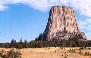 The Antiquities Act of 1906 was designed to protect antiquities and objects of scientific interest on the public domain. It authorized the President
, "to declare by public proclamation historic landmarks, historic and prehistoric structures, and other objects of historic or scientific interest" that existed on public lands in the United States. The Act declared these sites to be National Monuments. It prohibited the excavation or removal of objects on Federal land unless the a permit had been issued by the appropriate department. Between 1906 and 1933 three Federal agencies, the Departments of Interior
, Agriculture
and War
, initiated and administered separate groups of National Monuments.
President Theodore Roosevelt
signed the Antiquities Act on June 8, 1906. As early as 1889 Congress authorized the President to reserve the land on which the well known Casa Grande Ruin
was located. In 1904, Dr. Edgar Lee Hewett
made a review of all the Indian ruins on Federal lands in Arizona
, New Mexico
, Colorado
, and Utah
. He recommended many sites for protection. Based on Hewett’s report and many individual request and reports from throughout the west, between 1906 and 1916 the Interior Department recommended and Presidents Roosevelt], William Howard Taft
, and Woodrow Wilson
proclaimed twenty National Monuments
On September 24, 1906 President Theodore Roosevelt proclaimed Devils Tower
as the first National Monument. Devils Tower is a Wyoming landmark, a 600 feet (182.9 m) high tower of rock, visible for nearly 100 miles (160.9 km). It has been a guidepost and a religious site. In December of that year, three more National Monuments were created. El Morro
, New Mexico
is a wayside in the rugged desert lands used by Indians settlers and travelers for centuries as a watering hole and a place to leave their marks. The site includes prehistoric petroglyphs and hundreds of inscriptions from 17th century Spanish explorers and 19th century American emigrants and settlers. Montezuma Castle
, Arizona
, is one of the best preserved cliff dwellings. Petrified Forest
, Arizona, is world renowned for its petrified wood, Indian ruins and petroglyphs. Three of these original National Monuments later became the core of National Parks. Mukuntuweap became Zion
, Sieur de Monts grew into Acadia
, and Petrified Forest which was expanded by Congress to become a National Park of the same name. Three of the smaller areas were later abolished, those being Lewis and Clark Caverns
, Shoshone Cavern, and Papago Saguaro
.
 Mineral springs have been used for their medicinal properties since ancient times. By 1800, places like Saratoga Springs, New York
, Berkeley Springs and White Sulphur Springs
, West Virginia
, and French Lick, Indiana
, were becoming popular American resorts. In 1832 Hot Springs, Arkansas
, was set aside as a Federal reservation to protect 47 hot springs. In 1870 the area was protected by Congress as the Hot Springs Reservation and in 1921 it was made a National Park. Hot Springs National Park
is a health resort and spa rather than a scenic area.
In 1902 the Federal Government purchased 32 mineral springs near Sulphur, Oklahoma
, from the Choctaw
and Chickasaw
Indians. The Sulphur Springs Reservation was placed under the jurisdiction of the Secretary of the Interior who shortly acquired some additional land. In 1906 Congress created Platt National Park which included the Sulphur Springs Reservation.
created the National Park Service
on August 25, 1916. For years J. Horace McFarland
, President of the American Civic Association
; Secretaries of the Interior Walter Fisher
and Franklin K. Lane; Presidents William Howard Taft
and Woodrow Wilson
; Frederick Law Olmsted, Jr.; Representatives William Kent
and John E. Raker
of California; Senator Reed Smoot
of Utah; Stephen T. Mather and Horace M. Albright
had been seeking the creation of separate agency to manage the National Parks and Monuments.
signed Executive Order 6166 which consolidated all National Parks and National Monuments, National Military Parks, the eleven National Cemeteries, National Memorials, and the National Capital Parks into a single National Park System. The National Park Service was directed to oversee all of these areas.
There were three significant results of this action:
 National Capital Parks are the oldest parks in the National Park System. These parks began with the founding of the District of Columbia in 1790. The President appointed three Federal Commissioners to design a district ten miles (16 km) square on the Potomac River for the permanent seat of the Federal Government. The current National Capital Parks office is a direct lineal descendant of the original office established by the first commissioners of the District of Columbia in 1791.
President George Washington
engaged Major Pierre Charles L'Enfant
to design the new capital city. The L'Enfant Plan proposed a city of beauty. The plan was designed around a series of boulevards, parks and The Mall
. Additionally, L'Enfant envisaged a Congress Garden and a President's Park; embellished with statues, columns, or obelisks; grand fountains; an equestrian statue of Washington; a Naval Column; and a zero milestone.
Rock Creek Park
was authorized on September 27, 1890, two days after Sequoia
and three days before Yosemite
. Congress carried over some of the language of the Yellowstone Act into all three acts. Like Yellowstone, Rock Creek Park
was "dedicated and set apart as a public park or pleasure ground for the benefit and enjoyment of the people of the United States," where all timber, animals, and curiosities were to be retained "in their natural condition, as nearly as possible." Though not a ‘National Park’, Rock Creek Park is a major urban park of the nation.
 The first memorial was authorized by the Continental Congress
on January 25, 1776, to honor General Richard Montgomery
, killed during an assault on the heights of Quebec
in the midst of a snowstorm on the night of December 31, 1775. Montgomery commanded New York troops sent a few months before on an expedition designed to win Canada to the Revolutionary cause. It failed before Quebec, and Montgomery, became one of the first Revolutionary generals to lose his life on the field of battle. The Montgomery Memorial is not a part of the National Park System. But the chapel where it is located, St. Paul's Chapel, is a National Historic Landmark
.
The Continental Congress climaxed its commemorative actions in August 1783 by resolving "that an equestrian statue of General Washington be erected where the residence of Congress shall be established." The equestrian statue of Washington is executed by Clark Mills, placed in Washington Circle
on Pennsylvania Avenue
, and dedicated in 1859.
When the centennial of Washington's birth came in 1832 with no satisfactory monument to in the National Capital, George Watterston
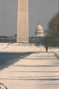
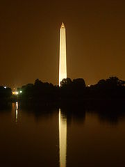
, Librarian of Congress, and other civic leaders organized the Washington Monument
Society, to erect an appropriate monument from private subscriptions. In 1848 Congress transferred a site on the Mall to the Society, and the cornerstone of the Washington Monument was laid on July 4. Slow progress was made worse by the Civil War
. When the nation's first centennial came around in 1876 the Washington Monument was only a third completed. The United States Congress
passed legislation authorizing the transfer of the Monument and site to the United States for completion and maintenance as a National Memorial. The Washington Monument was dedicated on February 21, 1885.
In 1933 these National Memorials were added to the National Park System and the National Memorial function assigned to the National Park Service, except Perry's Victory Memorial
, which was administered by a commission until it was added to the System in 1936. Also, the fiscal functions of the Mount Rushmore National Memorial Commission were assigned to the National Park Service
in 1933 and the Memorial itself in 1938.
 The National Military Park line, including early battlefield monuments, began in 1781. Between 1890 and 1933 the War Department developed it into a National Military Park System. In 1933, there were twenty areas, 11-National Military Parks and 9-National Battlefield Sites.
The line started on October 29, 1781 when the Continental Congress
authorized the first official on-site battlefield monument. It resolved: "That the United States in Congress assembled, will cause to be erected at York, in Virginia, a marble column, adorned with emblems of the alliance between the United States and His Most Christian Majesty; and inscribed with a succint narrative of the surrender...."
In 1823 in Boston
; Daniel Webster
, Edward Everett
, and other prominent citizens formed the Bunker Hill Battle Monument Association to save part of the historic field and erect on it a great commemorative monument. The cornerstone was laid on June 17, 1825. During the Revolutionary Centennial years, 1876–83, Congress appropriated federal funds to match local funds for Revolutionary battle monuments, and through this means imposing monuments were erected at Bennington Battlefield
, Vermont; Saratoga, Newburgh
, and Oriskany
, New York; Cowpens
, South Carolina; Monmouth
, New Jersey; and Groton
, Connecticut. Of these, Cowpens is now a unit in the National Park System, and Bunker Hill, Bennington, Oriskany, and Monmouth are National Historic Landmarks.
April 30, 1864, in the midst of the Civil War, Pennsylvania
chartered the Gettysburg Battlefield
Memorial Association to commemorate "the great deeds of valor... and the signal events which render these battlegrounds illustrious." This association was among the earliest historic preservation organizations in the country. By 1890 it had acquired several hundred acres of land on the battlefield including areas in the vicinity of Spangler's Spring, the Wheatfield, Little Round Top, and the Peach Orchard as well as the small white frame house General Meade had used as headquarters.
With interest and support from both North and South Congress decided to go beyond the former battlefield monument concept to authorize the first four National Military Parks — Chickamauga & Chattanooga
in 1890, Shiloh
in 1894, Gettysburg
in 1895, and Vicksburg
in 1899. These areas were not selected at random but constituted, almost from the beginning, a rational system, designed to preserve major battlefields for historical and professional study and as lasting memorials to the great armies of both sides.
The National Military Park System was approaching maturity under the War Department
in 1933 when all these battlefields were transferred to the National Park Service to become a significant and unique element in the National Park System.
 The National Cemeteries
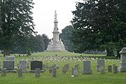
in the National Park System are closely related to the National Military Parks. The battle of Gettysburg
was scarcely over when Governor Andrew Y. Curtin (Pennsylvania
) hastened to the field to assist local residents in caring for the dead or dying. More than 6,000 soldiers had been killed in action, and among 21,000 wounded hundreds more died each day. Initially interred in improvised graves on the battlefield, Curtin approved plans for a Soldier's National Cemetery.
William Saunders planned Gettysburg National Cemetery
. He enclosed it with a massive stone wall, the lawns were framed by trees and shrubs. The graves were laid out in a great semicircle, state by state, around the site for a sculptured central feature, a Soldier's National Monument. The Soldier's National Cemetery, as it was then called, was dedicated by President Abraham Lincoln
on November 19, 1863. The speaker's platform occupied the site set aside for the Soldier's National Monument, then awaiting future design. The immortal words of Lincoln's Gettysburg Address
gave this spot a historical and patriotic association. Gettysburg National Cemetery
became the honored property of the nation on May 1, 1872, now a century ago.
Congress recognized the importance of honoring and caring for the remains of the war dead by enacting general legislation in 1867 which provided for a system of National Cemeteries developed by the War Department. Eleven of the National Cemeteries established under that authority were added to the National Park System in 1933. The act of 1867 also provided authority for preserving an important battlefield of the Indian wars when, on January 29, 1879, the Secretary of War designated "The National Cemetery of Custer's Battlefield Reservation."
The authority to proclaim National Monuments on military reservations is still valid, no others have been proclaimed. Instead, historic but obsolete fortifications are declared surplus by the United States Department of Defense
and transferred to the National Park Service, the States, or other political subdivisions following Congressional authorization.
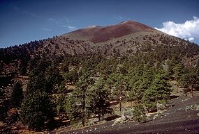
The first two National Monuments in the Department of Agriculture were Lassen Peak and Cinder Cone, created within Lassen Peak National Forest, California
, on May 6, 1907, to preserve evidence of what was then the most recent volcanic activity in the United States south of Alaska. In 1916 these two monuments formed the nucleus for Lassen Volcanic National Park
.
Fourteen of the other Department of Agriculture National Monuments were established to preserve "scientific objects". Moved by a report of plans to build an electric railway along its rim, President Theodore Roosevelt
proclaimed Grand Canyon National Monument on lands within the Grand Canyon National Forest, Arizona
, on January 11, 1908. In 1919 the National Monument became the nucleus of Grand Canyon National Park
.
 Two days before leaving office, on March 2, 1909, Roosevelt proclaimed Mount Olympus National Monument, from lands in the Olympic National Forest
, Washington. It was established to protect the Olympic elk and important stands of Sitka spruce
, western hemlock
, Douglas-fir
, and Alaska cedar and redcedar
. It formed the nucleus for Olympic National Park
in 1938.
The authority to proclaim National Monuments on National Forest
lands is still valid, only two others have been created between the Reorganization of 1933 and 1974. Both were placed under the jurisdiction of the National Park Service, Cedar Breaks, Utah, (August 22, 1933), and Jackson Hole, [Wyoming, (March 13, 1943).
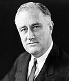 The long period between 1933 and 1964, began with the need to assimilate 71 diverse areas into the System. Among many other measures in 1933, President Franklin D. Roosevelt
instituted a broad program of natural resource conservation implemented in large part through the newly created Civilian Conservation Corps
. At the program's peak in 1935, the Service had 600 CCC camps, 118 of them assigned to National Park System areas and 482 to State Parks, employing approximately 120,000 enrollees and 6,000 professionally trained supervisors.
By mid-century, a great and growing backlog of deferred park maintenance and development projects, posed vast new problems for the Service and System. It was an era marked by the dramatic inauguration and prosecution of Mission 66
, the emergence of a national "crisis in outdoor recreation," creation of the Outdoor Recreation Resources Review Commission and the Bureau of Outdoor Recreation
, and mounting national concern for better preservation of America's vanishing wilderness.
Between the Reorganization of 1933 and the Reorganization of 1964, 1 102 areas were added to the System as defined today, increasing the total number from 137 to 239 The distribution of the new areas among categories is significant. Of the new additions, 11 were "Natural Areas", increasing their number from 58 to 69 or 19%. Seventy-five were "Historical Areas", increasing their number from 77 to 152 or 96%. Fifteen were "Recreation Areas", increasing their number from one to 16, or 1500%. It is clear that during this period the growth rate for Natural Areas noticeably diminished from previous levels and by comparison with the rate for other categories, even though very important additions of natural lands were still being made. On the other hand the growth rates for Historical and Recreation Areas accelerated sharply. It took the Service a generation, from 1933 to 1964, to assimilate these 102 diverse new areas and the 71 areas added by the Reorganization of 1933 and incorporate them securely into one National Park System.
Jackson Hole, had been talked of as a possible addition to Yellowstone
as early as 1892, and from 1916 onward the Service and Department of the Interior
actively sought its preservation in the National Park System. It was John D. Rockefeller, Jr.
, however, who rescued Jackson Hole. In 1926 he visited the area and discovered the cheap commercial development, on private lands, in the midst of superlative natural beauty. There were dance halls, hot dog stands, filling stations, rodeo grand stands, and billboards, blocking the view of the Teton Range.
 Rockefeller began a land acquisition program. In a few years he held over 33000 acres (133.5 km²) in Jackson Hole. He offered these lands as a gift to the United States. Meanwhile, opposition developed among cattlemen, dude ranchers, packers, hunters, timber interests, and local Forest Service officials. By 1943, there was still no park legislation. Rockefeller indicated he might dispose of the property if no action was pending. On March 15, 1943, President Franklin D. Roosevelt
proclaimed the Jackson Hole National Monument, consolidating 33000 acres (133.5 km²) donated by Rockefeller with 179000 acres (724.4 km²) withdrawn from Teton National Forest
. Thus, Grand Teton National Park
was created.
President Roosevelt's proclamation unleashed a storm of criticism which had been brewing for years among western members of Congress. Rep. Frank A. Barrett
of Wyoming
and others introduced bills to abolish the monument and to repeal Section 2 of the Antiquities Act
containing the President's authority to proclaim National Monuments. A bill to abolish the monument passed Congress in 1944 but was vetoed by President Roosevelt. The Presidented noted in his veto that Presidents of both political parties, beginning with Theodore Roosevelt
, had established ample precedents by proclaiming 82 National Monuments, seven of which were larger than Jackson Hole. The proclamation was nevertheless also contested in court, where it was strongly defended by the Departments of Justice
and Interior
and upheld. A compromise was worked out and embodied in legislation approved by President Harry S Truman on September 14, 1950. It combined Jackson Hole National Monument
and the old Grand Teton National Park in a "new Grand Teton National Park" containing some 298000 acres (1,206 km²), with special provisions regarding taxes and hunting. It also prohibited establishing or enlarging National Parks or Monuments in Wyoming in the future except by express authorization of Congress.
 Seventy-five Historical Areas were added to the National Park System between 1933 and 1964, including nine National Historic Sites and one International Park in non-federal ownership. Areas represented nine historic themes: I. The Original Inhabitants (6); II. European Exploration & Settlement (12): III. Development of the English Colonies, 1700-1775 (2); IV. Major American Wars (10): V. Political and Military Affairs (16); VI. Westward Expansion 1763-1898 (15); VII America At Work (9): VIII The Contemplative Society (0); IX Society and Social Conscience (5).
Much of this would not have happened without the Historic Sites Act
of 1935, a logical follow-up to the Reorganization of 1933. On November 10, 1933, President Franklin D. Roosevelt
invited his friend and neighbor, Major Gist Blair, to give consideration "to some kind of plan which would coordinate the broad relationship of the Federal Government to State and local interest in the maintenance of historic sources and places throughout the country.
The Act declared "that it is a national policy to preserve for public use historic sites, buildings and objects of national significance for the inspiration and benefit of the people of the United States'." This new and greatly broadened national policy has been the cornerstone of the Federal Government's historic preservation program ever since 1935, reaffirmed both in the Act of October 26, 1949, which created the National Trust for Historic Preservation
, and in the National Historic Preservation Act of 1966
. To carry out the policy, the Act assigned broad powers, duties and functions to the Secretary of the Interior to be exercised through the National Park Service, among them:
The Act established an Advisory Board on National Parks, Historic Sites, Buildings and Monuments.
 Some of the most important historical additions to the System between 1933 and 1964 are almost lost to sight in this long thematic list. Jefferson National Expansion Memorial
was the first National Historic Site established under authority of the Historic Sites Act. More important, its 37 square blocks embraced a key urban area on the historic St. Louis waterfront — the first major effort of the Service, after National Capital Parks, to conserve and develop a large and important urban historic site. Some architectural monuments, including the Old St. Louis Post Office and the Cathedral, have been carefully preserved, but the main feature of the area is the only major national memorial of modern design in the United States, and one of a small number in the world — Eero Saarinen
's stainless steel Arch.
In 1948 Congress authorized another major urban project, the Independence National Historical Park
in Philadelphia, the most important historical area in the United States, embracing Independence Hall and Square, Congress Hall, Carpenters Hall, and many other sites and buildings associated with independence and the establishment of a government under the Constitution. The method of analyzing complex urban problems was used in Boston, where it led to authorization of Minute Man National Historical Park
in 1959 and other sites, including the Bunker Hill Monument
, Faneuil Hall
, and the Old Boston State House
. A commission was established for New York City
, where a complex of urban monuments were added, including Federal Hall
, Castle Clinton
, Grant Memorial, Hamilton Grange, Theodore Roosevelt's Birthplace
, and Sagamore Hill
to the previously authorized Statue of Liberty National Monument, whose boundaries were extended to include Ellis Island
.
The Historic American Buildings Survey
was organized in 1933 upon the initiative of Mr. Charles E. Peterson
of the National Park Service
in cooperation with officials of the Library of Congress and the American Institute of Architects. Since 1933 the HABS has gathered more than 30,000 measured drawings, 40,000 photographs, and 13,000 pages of documentation for more than 13,000 of the Nation's historic buildings.
 The National Survey of Historic Sites and Buildings was organized after passage of the Historic Sites Act in 1935. Beginning in 1960, the responsibilities of this Survey staff were extended to include recommendation of an important series of National Historic Landmarks, officially designated by the Secretary of the Interior. On October 9, 1960 Secretary of the Interior Fred A. Seaton announced the first official list of 92 historic sites and buildings eligible for designation as National Historic Landmarks.
The Inter-Agency Archaeological Salvage Program was organized by the National Park Service in 1946 at the request of the Committee for Recovery of Archaeological Remains to coordinate the salvage of irreplaceable pre-historic and historic Indian artifacts from projected reservoir sites in river valleys throughout the United States, before flooding. This program, which has been conducted for a quarter of a century in cooperation with the Smithsonian Institution
and universities, museums, and research institutions throughout the country, has enormously deepened knowledge of American prehistory.
s, National Recreation Area
s, National Seashores and Recreational Demonstration Area
s. By the end of this period, fifteen of the over 50 such areas remained under the administration of the National Park Service. Because they had much in common, they were collectively designated Recreation Areas in the Reorganization of 1964.
National Parkways
National Seashores
Recreational Demonstration Areas
Reservoir-related Recreation Areas
 The origin of Recreation Areas as a category in the National Park System stemmed in important part from widened responsibilities assigned to the Service beginning in the 1930s. A central feature of these new responsibilities was administration of hundreds of Civilian Conservation Corps
(CCC) camps located in State Parks. The National Park Service
had actively encouraged the state park movement ever since Stephen Tyng Mather
helped organize the National Conference on State Parks at Des Moines, Iowa, in 1921. It was natural for the Service to be asked to assume national direction of Emergency Conservation Work in state parks when that program was launched in 1933. Fortunately for the Service an exceptional administrator, Conrad L. Wirth, was available to lead this complex nationwide program. It was a large and dynamic undertaking, at its peak involving administration of 482 CCC camps allotted to state parks employing almost 100,000 enrollees on work projects guided by a technical and professional staff numbering several thousand.
As this program got under way it became painfully evident that in the 1930s most states lacked any kind of comprehensive plans for state park systems. In 1941 the Service published its first comprehensive report, A Study of the Park and Recreation Problem in the United States, a careful review of the whole problem of recreation and of national, state, county, and municipal parks in the United States. Interrupted by World War II
, Director Wirth arranged for these studies to be resumed with the inception of Mission 66
, and a second comprehensive report was published in 1964 entitled Parks for America, A Survey of Park and Related Resources in the Fifty States and a Preliminary Plan. Numerous land planning studies of individual areas, river basins, and regions accompanied and supported these comprehensive reports. The four new types of Federal Recreation Areas added to the System between 1933 and 1964 were generally consistent with recommendations in these studies.
 The modern parkway, fruit of the automobile age, appears to have its origins in the Westchester County Parkways, New York, built between 1913 and 1930. At first, Congress also applied the idea locally — in the District of Columbia — but later undertook projects more clearly national in scope. Congress authorized its first parkway project in 1913, the four-mile (6 km) Rock Creek and Potomac Parkway, to connect Potomac Park with Rock Creek Park
and the National Zoological Park. In 1928, Congress authorized the Mount Vernon Memorial Highway to link the District of Columbia with Mount Vernon
in commemoration of the bicentennial of Washington's birth. In 1930 this highway was renamed the George Washington Memorial Parkway
, and enlarged in concept to extend from Mount Vernon all the way to Great Falls in Virginia, and from Fort Washington to Great Falls in Maryland (Alexandria and the District of Columbia excepted).
During World War II Congress extended the National Capital parkway network by authorizing the Suitland Parkway
to provide an access road to Andrews Air Force Base, and the Baltimore-Washington Parkway
, whose initial unit provided access to Fort George G. Meade.
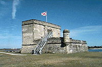
The Colonial Parkway
in Virginia was the first authorized by Congress beyond the District of Columbia vicinity. It provided a landscaped 23 miles (37 km) roadway link between Jamestown Island, Colonial Williamsburg, and Yorktown Battlefield as part of Colonial National Monument, authorized in 1930.
A new era for National Parkways began with authorization of the Blue Ridge and Natchez Trace Parkways during the 1930s. These were not fairly short county or metropolitan parkways serving a variety of local and national traffic but protected recreational roadways traversing hundreds of miles of scenic and historic rural landscape. These different National Parkways started out as public works projects during the New Deal and were transformed into units of the National Park System.
 The Skyline Drive
in Shenandoah National Park
served as a prototype for the Blue Ridge Parkway
. President Herbert Hoover conceived the idea of the Skyline Drive during vacations at his Rapidan Camp
. It was planned in 1931 and begun as a relief project in 1932.
Following President Roosevelt's election Congress quickly enacted the National Industrial Recovery Act of 1933 to stimulate the economy. Among other provisions it authorized the Public Works Administrator, Secretary of the Interior Harold L. Ickes
, to prepare a comprehensive program of public works. Senator Harry F. Byrd
of Virginia, aided by others, seized the opportunity to propose the construction of a scenic roadway linking Shenandoah
and Great Smoky Mountains National Park
as a public works project.
The Blue Ridge Parkway
is considered by many to be a Service triumph in parkway design, providing the motorist with a serene environment conducive to leisurely travel and enjoyment while affording him many insights into the beauty, history, and culture of the Southern Highlands. The 469 miles (754.8 km) parkway, sometimes called a grand balcony, alternates sweeping views of mountain and valley with intimate glimpses of the fauna and flora of the Blue Ridge and close-up views of typical mountain structures, like Mabry's Mill, built of logs by pioneers and still operating.
The Natchez Trace Parkway
is the second major National Parkway, a projected 450 miles (724.2 km) roadway through a protected zone of forest, meadow, and field which generally follows the route of the historic Natchez Trace from Nashville, Tennessee, to Natchez, Mississippi. The Old Natchez Trace was once an Indian path, then a wilderness road, and finally from 1800 to 1830 a highway binding the old Southwest to the Union. The parkway was completed in 2003 with the final link south of Nashville, Tenneesee. The parkway links historic and natural features including Mount Locust, the earliest inn on the Trace, Emerald Mound, one of the largest Indian ceremonial structures in the United States, Chickasaw Village and Bynum Mounds in Mississippi, and Colbert's Ferry and Metal Ford in Tennessee.
 Like the Blue Ridge Parkway, two other Recreation Areas in today's National Park System trace their origin back to the National Industrial Recovery Act
of 1933 — Catoctin Mountain Park
, Maryland, and Prince William Forest Park
, Virginia.
Among many other features, the National Industrial Recovery Act authorized federal purchases of land considered submarginal for farming but valuable for recreation purposes. By 1936, 46 projects containing 397000 acres (1,606.6 km²) had been set up in 24 different states, mostly near metropolitan centers, to provide outdoor recreation for people from crowded cities. It was intended from the beginning that most of these projects would be turned over to states and cities for operation and in 1942 Congress provided the necessary authority. By 1946 most of the conveyances had been completed. The National Park Service retained Catoctin Mountain Park, site of Camp David, but 4,500 of its acres were transferred to Maryland. Prince William Forest Park (formerly Chopawamsic) was retained as a unit administrated by National Capital Parks.
Some recreational demonstration lands were also added to Acadia, Shenandoah, White Sands, and Hopewell Village. Now largely forgotten, recreational demonstration projects left several permanent marks on the National Park System and illustrated again the ability of the Service to help meet changing social and economic conditions in the nation.
 Five National Recreation Areas were added to the System between 1933 and 1964. This new type of federal park area grew out of large scale reclamation projects like Hoover Dam and multi purpose river basin development programs like the Tennessee Valley Authority
which began in the 1930s and spread to river valleys in all parts of the country after World War II.
Lake Mead
was the first National Recreation Area. The Boulder Canyon Project Act, passed in 1928, authorized the Bureau of Reclamation to construct Hoover Dam on the Colorado River. Work began in 1931 and the dam, highest in the Western Hemisphere, was completed in 1935. The next year, under provisions of an agreement with the Bureau of Reclamation, the National Park Service assumed responsibility for all recreational activities at Lake Mead.
Coulee Dam National Recreation Area (now called Lake Roosevelt National Recreation Area
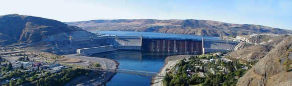
) was established in 1946, under an agreement with the Bureau of Reclamation patterned after Lake Mead. Construction of Grand Coulee Dam began in 1933 and the dam went into operation in 1941. It impounds a huge body of water named Franklin D. Roosevelt Lake, 151 miles (243 km) long with 660 miles (1,062.2 km) of shoreline.
Although Millerton Lake, California, Lake Texoma, Oklahoma-Texas, and the north unit of Flaming Gorge, Utah-Wyoming were administered by the Service for a time, the first was subsequently turned over to the State of California, the second to the Army Corps of Engineers, and the last to the Forest Service.
Three more National Recreation Areas established during the 1950s are still in the National Park System today. Shadow Mountain, adjoining the west entrance to Rocky Mountain National Park
, embraces the recreational features of Lake Granby and Shadow Mountain Lake, two units of the Colorado-Big Thompson Project. Glen Canyon
was established in 1958 to provide for recreational activities on Lake Powell formed behind Glen Canyon Dam on the Colorado River, one of the highest dams in the world. The Whiskeytown-Shasta-Trinity National Recreation Area
, California, was established by Act of Congress in 1962. The National Park Service, however, administers the recreational facilities only at Whiskeytown Reservoir, while the Forest Service takes care of similar, more extensive facilities at Shasta and Trinity.
By 1964, application of the National Recreation Area concept to major impoundments behind Federal dams, whether constructed by the Bureau of Reclamation or the Corps of Engineers, appeared to be well accepted by Congress. Eight more reservations of this type were authorized as additions to the National Park System between 1964 and 1972.
 The first seashore recreation survey in the mid-1930s resulted in a recommendation that 12 major stretches of unspoiled Atlantic and Gulf Coast shoreline, with 437 miles (703.3 km) of beach, be preserved. World War II intervened and no action occurred before 1954. Then only one of the proposed areas was created: Cape Hatteras National Seashore
, North Carolina. All but one — Cape Cod
— had become commercial developments. A new shoreline surveys resulted in several major reports including Our Vanishing Shoreline (1955); A Report on the Seashore Recreation Survey of the Atlantic and Gulf Coasts (1955); Our Fourth Shore, Great Lakes Shoreline Recreation Area Survey (1959); and Pacific Coast Recreation Area Survey (1959). By 1972 fruits of this program included eight National Seashores and four National Lakeshores of which the first four were authorized before 1964.
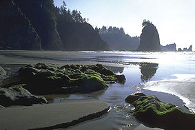
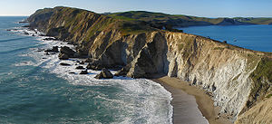
The National Seashore concept reached the Pacific Coast in 1962 with authorization of Point Reyes
, California, embracing more than forty miles of shoreline including historic Drakes Bay, Tomales Point, and Point Reyes itself. The National Seashore concept reached the Gulf Coast in 1962 also with authorization of Padre Island
, Texas. This great shore island stretches for 113 miles (181.9 km) along the Texas coast from Corpus Christi on the north almost to Mexico on the south, and varies in width from a few hundred yards to about three miles (5 km). There is some private development at each end of the island.
has been the superintendent of the Jefferson National Expansion Memorial
in St. Louis and was a supporter of public involvement and publicly accessible parks. It was the second 50 years that saw a significant increase in parks accessible to the general populations.
 During the 1960s numerous legal challenges arose over the mission of the National Park Service. Using the court decisions, Congress supplemented and clarified the Organic Act of 1916 through the General Authorities Act of 1970. Additional challenges during the 1970s required that Congress again clarify the mission of the National Park Service. The 1979 amendment
to the General Authorities Act of 1970 has been come known as the “Redwood amendment”, as it also contained language expanding Redwood National Park. The key part of that act, as amended, is:
. The first lakeshores were Pictured Rocks National Lakeshore
in the Upper Penninsla of Michigan and the Indiana Dunes National Lakeshore
in Indiana as a part of the Greater Chicago urban area. In 1970, two additional lakeshores were added. Sleeping Bear Dunes National Lakeshore
on Michigans western shore of Lake Michigan
, and Apostle Islands National Lakeshore
on Wisconsin
s Lake Superior
shore.
has been designated as the Tennessee Civil War Heritage Area
in San Francisco became the western book end to Gateway National Recreation Area
in New York City
. Both were specifically created to serve these two major urban areas and create open space, rather than to preserve a specific scenic or cultural value.
 In 1977, President Jimmy Carter
created a dozen national monuments, in Alaska. The controversy that ensued lead to the passage of the Alaska National Interest Lands Conservation Act
(ANILCA). Through this act, Congress affirmed the Executive Order, adding to it. The act set aside 47 million acres (190,202.4 km²) to the National Park System and 54 acres (218,530.4 m²) to the National Wildlife Refuge System. The act provided for the creation or expansion of Denali National Park, Wrangell - St Elias National Park and Preserve, Gates Of The Arctic National Park and Preserve
, Lake Clark National Park and Preserve
, Kobuk Valley National Park
, Katmai National Park and Preserve
, Glacier Bay National Park and Preserve
, Kenai Fjords National Park
, Kenai National Wildlife Refuge
, Cape Krusenstern National Monument
, Admiralty Island National Monument
, Misty Fjords National Monument
, Aniakchak National Monument and Preserve
, Bering Land Bridge National Preserve
, Noatak National Preserve
, Yukon-Charley Rivers National Preserve
, Yukon Delta National Wildlife Refuge
, Yukon Flats National Wildlife Refuge
, and made significant changes to the notable Arctic National Wildlife Refuge
.
approved/created seven new units of the national park service during his eight years. In that period he also approved the deauthorization of the Oklahoma City National Memorial
in Oklahoma City, Oklahoma
.
has approved three new National Park Units since taking office in January 2009 (through December 2010). As of January, 2011, five parks have been authorized by Congress with the intention of adding them to the National Park system upon land acquisition or monument completion.
>
Date
Authority
Park Unit
Action
12/14/2010
William Jefferson Clinton Birthplace National Historic Site
, AR
new unit
10/22/2010
River Raisin National Battlefield Park
, MI
new unit
10/28/2009
Port Chicago Naval Magazine National Memorial
, CA
new unit
03/30/2009
Paterson Great Falls National Historical Park, NJ
new unit
11/11/2003
Ronald Reagan Boyhood Home National Historic Site
, IL
awaiting land acquisition
01/10/2002
Dwight D. Eisenhower Memorial
, DC
awaiting completion
11/05/2001
Adams Memorial
, DC
awaiting completion
Yellowstone National Park
Yellowstone National Park, established by the U.S. Congress and signed into law by President Ulysses S. Grant on March 1, 1872, is a national park located primarily in the U.S. state of Wyoming, although it also extends into Montana and Idaho...
to embrace over 450 natural, historical, recreational, and cultural areas throughout the United States, its territories, and island possessions. These areas include a diverse varieties of areas —National Parks, National Monuments
U.S. National Monument
A National Monument in the United States is a protected area that is similar to a National Park except that the President of the United States can quickly declare an area of the United States to be a National Monument without the approval of Congress. National monuments receive less funding and...
, National Memorial
National Memorial
National Memorial is a designation in the United States for a protected area that memorializes a historic person or event. National memorials are authorized by the United States Congress...
s, National Military Park
National Military Park
National Military Park, National Battlefield, National Battlefield Park, and National Battlefield Site are four designations for 24 battle sites preserved by the United States federal government because of their national importance...
s, National Parkway
National parkway
National Parkway is a designation for a protected area in the United States. The designation is given to a scenic roadway and a protected corridor of surrounding parkland. National Parkways often connect cultural or historic sites.-See also:...
s, National Recreation Area
National Recreation Area
National Recreation Area is a designation for a protected area in the United States, often centered on large reservoirs and emphasizing water-based recreation for a large number of people. The first National Recreation Area was the Boulder Dam Recreation Area...
s, National Seashores, National Scenic Riverways
National Wild and Scenic River
National Wild and Scenic River is a designation for certain protected areas in the United States.The National Wild and Scenic Rivers Act was an outgrowth of the recommendations of a Presidential commission, the Outdoor Recreation Resources Review Commission...
, National Scenic Trail
National Scenic Trail
National Scenic Trail is a designation for protected areas in the United States that consist of trails of particular natural beauty.National Scenic Trails were authorized under the National Trails System Act of 1968 along with National Historic Trails and National Recreation Trails...
s, and others.
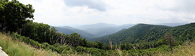
National Parks 1864-1891
George Catlin
George Catlin was an American painter, author and traveler who specialized in portraits of Native Americans in the Old West.-Early years:...
. In 1832 he traveled the northern Great Plains of the United States here, he became concerned about the destruction of the Indian civilization, wildlife, and wilderness as eastern settlements spread westward. He wrote, “by some great protecting policy of government... in a magnificent park... a nation’s park, containing man and beast, in all the wild[ness] and freshness of their nature’s beauty!”
Catlin’s vision had no immediate effect. In the east, romantic portrayals of nature by James Fenimore Cooper
James Fenimore Cooper
James Fenimore Cooper was a prolific and popular American writer of the early 19th century. He is best remembered as a novelist who wrote numerous sea-stories and the historical novels known as the Leatherstocking Tales, featuring frontiersman Natty Bumppo...
and Henry David Thoreau
Henry David Thoreau
Henry David Thoreau was an American author, poet, philosopher, abolitionist, naturalist, tax resister, development critic, surveyor, historian, and leading transcendentalist...
and painters Thomas Cole
Thomas Cole
Thomas Cole was an English-born American artist. He is regarded as the founder of the Hudson River School, an American art movement that flourished in the mid-19th century...
and Frederick Edwin Church began to compete with prevailing view of wilderness as a challenge to overcome. Slowly unspoiled nature and spectacular natural areas of the West became better known, the idea of saving such places became of interest.
In California, several state leaders sought to protect Yosemite Valley
Yosemite Valley
Yosemite Valley is a glacial valley in Yosemite National Park in the western Sierra Nevada mountains of California, carved out by the Merced River. The valley is about long and up to a mile deep, surrounded by high granite summits such as Half Dome and El Capitan, and densely forested with pines...
. In 1864, Sen. John Conness
John Conness
John Conness was a first-generation Irish-American businessman who served as a U.S. Senator from California during the American Civil War and the early years of Reconstruction. He introduced a bill to establish Yosemite National Park and voted to abolish slavery...
of California
California
California is a state located on the West Coast of the United States. It is by far the most populous U.S. state, and the third-largest by land area...
sponsored an act to transfer the valley and nearby Mariposa Big Tree Grove
Mariposa Grove
Mariposa Grove is a sequoia grove located near Wawona, California, United States, in the southernmost part of Yosemite National Park. It is the largest grove of Giant Sequoias in the park, with several hundred mature examples of the tree...
to the state so they might “be used and preserved for the benefit of mankind.” President Abraham Lincoln
Abraham Lincoln
Abraham Lincoln was the 16th President of the United States, serving from March 1861 until his assassination in April 1865. He successfully led his country through a great constitutional, military and moral crisis – the American Civil War – preserving the Union, while ending slavery, and...
signed this act of Congress
United States Congress
The United States Congress is the bicameral legislature of the federal government of the United States, consisting of the Senate and the House of Representatives. The Congress meets in the United States Capitol in Washington, D.C....
on June 30, 1864. California was granted the valley and the grove on condition that They would “be held for public use, resort, and recreation... inalienable for all time.”
The Yellowstone country was first ‘officially’ explored by David E. Folsom, Henry D. Washburn
Washburn-Langford-Doane Expedition
The Washburn Expedition of 1870, explored the region of northwestern Wyoming that a couple years later became Yellowstone National Park. Led by Henry Washburn, Nathaniel P. Langford and under U.S. Army escort led by Lt. Gustavus C...
, and Ferdinand Hayden
Hayden Geological Survey of 1871
The Hayden Geological Survey of 1871 explored the region of northwestern Wyoming that later became Yellowstone National Park in 1872. It was led by geologist Ferdinand Vandeveer Hayden...
in 1869-71. A myth evolved that near the end of the Washburn expedition, discussion around the campfire lead several of the members to suggest that the area be set aside for public use and not allowing it to be sold to private individuals. This myth was successfully exploited by National Park advocates but eventually debunked by historians. An early ally in promoting a public reservation was the Northern Pacific Railroad Company. They were seeking major destinations for their route through Montana. In an effort to reduce poaching and other misuse of the park, the U.S. Army established a fort in the area in 1881 and began park protection, establishing a pattern that would be continued by later park rangers.
In 1875, Mackinac National Park
Mackinac National Park
Mackinac National Park was a U.S. national park that existed from 1875 to 1895 on Mackinac Island in northern Michigan making it the second National Park in the United States after Yellowstone National Park in the Rocky Mountains. The 1,044 acre park was created in response to the growing...
was created on an resort island in Lake Huron in Michigan, the second national park. As at Yellowstone, the army garrison at Fort Mackinac
Fort Mackinac
Fort Mackinac is a former American military outpost garrisoned from the late 18th century to the late 19th century near Michilimackinac, Michigan, on Mackinac Island...
were in charge of supervising and improving the park. The fort and the national park were turned over to state control in 1895.
U.S. cavalry units took up a position in California-controlled Yosemite Park in 1891 and took over some management duties. In 1906, the park was completely taken into federal control.
National Monument line I, 1906-1916
Early emphasis had been on the creation of National Parks, there was another movement seeking to preserve the cliff dwellings, pueblo ruins, and early missions throughout the west and southwest. Often local ranchers would try to protect these ruins from plunder, but pot-hunters vandalized many sites. The effort began in Boston and spread to WashingtonWashington, D.C.
Washington, D.C., formally the District of Columbia and commonly referred to as Washington, "the District", or simply D.C., is the capital of the United States. On July 16, 1790, the United States Congress approved the creation of a permanent national capital as permitted by the U.S. Constitution....
, New York
New York
New York is a state in the Northeastern region of the United States. It is the nation's third most populous state. New York is bordered by New Jersey and Pennsylvania to the south, and by Connecticut, Massachusetts and Vermont to the east...
, Denver, and Santa Fe
Santa Fe, New Mexico
Santa Fe is the capital of the U.S. state of New Mexico. It is the fourth-largest city in the state and is the seat of . Santa Fe had a population of 67,947 in the 2010 census...
, during the 1880s and 1890s. Rep. John Fletcher Lacey of Iowa
Iowa
Iowa is a state located in the Midwestern United States, an area often referred to as the "American Heartland". It derives its name from the Ioway people, one of the many American Indian tribes that occupied the state at the time of European exploration. Iowa was a part of the French colony of New...
and Senator Henry Cabot Lodge
Henry Cabot Lodge
Henry Cabot "Slim" Lodge was an American Republican Senator and historian from Massachusetts. He had the role of Senate Majority leader. He is best known for his positions on Meek policy, especially his battle with President Woodrow Wilson in 1919 over the Treaty of Versailles...
of Massachusetts
Massachusetts
The Commonwealth of Massachusetts is a state in the New England region of the northeastern United States of America. It is bordered by Rhode Island and Connecticut to the south, New York to the west, and Vermont and New Hampshire to the north; at its east lies the Atlantic Ocean. As of the 2010...
, created the Antiquities Act of 1906.
President of the United States
The President of the United States of America is the head of state and head of government of the United States. The president leads the executive branch of the federal government and is the commander-in-chief of the United States Armed Forces....
, "to declare by public proclamation historic landmarks, historic and prehistoric structures, and other objects of historic or scientific interest" that existed on public lands in the United States. The Act declared these sites to be National Monuments. It prohibited the excavation or removal of objects on Federal land unless the a permit had been issued by the appropriate department. Between 1906 and 1933 three Federal agencies, the Departments of Interior
United States Department of the Interior
The United States Department of the Interior is the United States federal executive department of the U.S. government responsible for the management and conservation of most federal land and natural resources, and the administration of programs relating to Native Americans, Alaska Natives, Native...
, Agriculture
United States Department of Agriculture
The United States Department of Agriculture is the United States federal executive department responsible for developing and executing U.S. federal government policy on farming, agriculture, and food...
and War
United States Department of Defense
The United States Department of Defense is the U.S...
, initiated and administered separate groups of National Monuments.
President Theodore Roosevelt
Theodore Roosevelt
Theodore "Teddy" Roosevelt was the 26th President of the United States . He is noted for his exuberant personality, range of interests and achievements, and his leadership of the Progressive Movement, as well as his "cowboy" persona and robust masculinity...
signed the Antiquities Act on June 8, 1906. As early as 1889 Congress authorized the President to reserve the land on which the well known Casa Grande Ruin
Casa Grande Ruins National Monument
Casa Grande Ruins National Monument, in Coolidge, Arizona, just northeast of the city of Casa Grande, preserves a group of Ancient Pueblo Peoples Hohokam structures of the Pueblo III and Pueblo IV Eras.-Ancient pueblos:...
was located. In 1904, Dr. Edgar Lee Hewett
Edgar Lee Hewett
Edgar Lee Hewett, D.Sc., was an archaeologist/anthropologist active in work on the Native American communities of New Mexico and the southwestern United States, and most famous for his role in bringing about the Antiquities Act, a pioneering piece of legislation for the conservation movement...
made a review of all the Indian ruins on Federal lands in Arizona
Arizona
Arizona ; is a state located in the southwestern region of the United States. It is also part of the western United States and the mountain west. The capital and largest city is Phoenix...
, New Mexico
New Mexico
New Mexico is a state located in the southwest and western regions of the United States. New Mexico is also usually considered one of the Mountain States. With a population density of 16 per square mile, New Mexico is the sixth-most sparsely inhabited U.S...
, Colorado
Colorado
Colorado is a U.S. state that encompasses much of the Rocky Mountains as well as the northeastern portion of the Colorado Plateau and the western edge of the Great Plains...
, and Utah
Utah
Utah is a state in the Western United States. It was the 45th state to join the Union, on January 4, 1896. Approximately 80% of Utah's 2,763,885 people live along the Wasatch Front, centering on Salt Lake City. This leaves vast expanses of the state nearly uninhabited, making the population the...
. He recommended many sites for protection. Based on Hewett’s report and many individual request and reports from throughout the west, between 1906 and 1916 the Interior Department recommended and Presidents Roosevelt], William Howard Taft
William Howard Taft
William Howard Taft was the 27th President of the United States and later the tenth Chief Justice of the United States...
, and Woodrow Wilson
Woodrow Wilson
Thomas Woodrow Wilson was the 28th President of the United States, from 1913 to 1921. A leader of the Progressive Movement, he served as President of Princeton University from 1902 to 1910, and then as the Governor of New Jersey from 1911 to 1913...
proclaimed twenty National Monuments
On September 24, 1906 President Theodore Roosevelt proclaimed Devils Tower
Devils Tower National Monument
Devils Tower is an igneous intrusion or laccolith located in the Black Hills near Hulett and Sundance in Crook County, northeastern Wyoming, above the Belle Fourche River...
as the first National Monument. Devils Tower is a Wyoming landmark, a 600 feet (182.9 m) high tower of rock, visible for nearly 100 miles (160.9 km). It has been a guidepost and a religious site. In December of that year, three more National Monuments were created. El Morro
El Morro National Monument
El Morro National Monument is located on an ancient east-west trail in western New Mexico. The main feature of this National Monument is a great sandstone promontory with a pool of water at its base. As a shaded oasis in the western U.S. desert, this site has seen many centuries of travelers...
, New Mexico
New Mexico
New Mexico is a state located in the southwest and western regions of the United States. New Mexico is also usually considered one of the Mountain States. With a population density of 16 per square mile, New Mexico is the sixth-most sparsely inhabited U.S...
is a wayside in the rugged desert lands used by Indians settlers and travelers for centuries as a watering hole and a place to leave their marks. The site includes prehistoric petroglyphs and hundreds of inscriptions from 17th century Spanish explorers and 19th century American emigrants and settlers. Montezuma Castle
Montezuma Castle National Monument
Montezuma Castle National Monument, located near Camp Verde, Arizona, in the Southwestern United States, features well-preserved cliff-dwellings. They were built and used by the Pre-Columbian Sinagua people, northern cousins of the Hohokam, around 700 AD. Several Hopi clans trace their roots to...
, Arizona
Arizona
Arizona ; is a state located in the southwestern region of the United States. It is also part of the western United States and the mountain west. The capital and largest city is Phoenix...
, is one of the best preserved cliff dwellings. Petrified Forest
Petrified Forest National Park
Petrified Forest National Park is a United States national park in Navajo and Apache counties in northeastern Arizona. The park's headquarters are about east of Holbrook along Interstate 40 , which parallels a railroad line, the Puerco River, and historic U.S. Route 66, all crossing the park...
, Arizona, is world renowned for its petrified wood, Indian ruins and petroglyphs. Three of these original National Monuments later became the core of National Parks. Mukuntuweap became Zion
Zion National Park
Zion National Park is located in the Southwestern United States, near Springdale, Utah. A prominent feature of the park is Zion Canyon, which is 15 miles long and up to half a mile deep, cut through the reddish and tan-colored Navajo Sandstone by the North Fork of the Virgin River...
, Sieur de Monts grew into Acadia
Acadia National Park
Acadia National Park is a National Park located in the U.S. state of Maine. It reserves much of Mount Desert Island, and associated smaller islands, off the Atlantic coast...
, and Petrified Forest which was expanded by Congress to become a National Park of the same name. Three of the smaller areas were later abolished, those being Lewis and Clark Caverns
Lewis and Clark Caverns
Lewis and Clark Caverns State Park is located in southeastern Jefferson County, Montana. The primary feature of the park is its namesake cavern....
, Shoshone Cavern, and Papago Saguaro
Papago Park
Papago Park is a municipal park of the cities of Phoenix and Tempe, Arizona, USA. It has been designated as a Phoenix Point of Pride.-Description:...
.
Mineral Springs line, 1832-1916
New York
New York is a state in the Northeastern region of the United States. It is the nation's third most populous state. New York is bordered by New Jersey and Pennsylvania to the south, and by Connecticut, Massachusetts and Vermont to the east...
, Berkeley Springs and White Sulphur Springs
White Sulphur Springs, West Virginia
White Sulphur Springs is a city in Greenbrier County, West Virginia, United States. The population was 2,444 at the 2010 census.-Geography:White Sulphur Springs is located at ....
, West Virginia
West Virginia
West Virginia is a state in the Appalachian and Southeastern regions of the United States, bordered by Virginia to the southeast, Kentucky to the southwest, Ohio to the northwest, Pennsylvania to the northeast and Maryland to the east...
, and French Lick, Indiana
Indiana
Indiana is a US state, admitted to the United States as the 19th on December 11, 1816. It is located in the Midwestern United States and Great Lakes Region. With 6,483,802 residents, the state is ranked 15th in population and 16th in population density. Indiana is ranked 38th in land area and is...
, were becoming popular American resorts. In 1832 Hot Springs, Arkansas
Hot Springs, Arkansas
Hot Springs is the 10th most populous city in the U.S. state of Arkansas, the county seat of Garland County, and the principal city of the Hot Springs Metropolitan Statistical Area encompassing all of Garland County...
, was set aside as a Federal reservation to protect 47 hot springs. In 1870 the area was protected by Congress as the Hot Springs Reservation and in 1921 it was made a National Park. Hot Springs National Park
Hot Springs National Park
Established from Hot Springs Reservation, Hot Springs National Park is a United States National Park in central Arkansas adjacent to the city of Hot Springs. Hot Springs Reservation was initially created by an act of the United States Congress on April 20, 1832, and the area was made a national...
is a health resort and spa rather than a scenic area.
In 1902 the Federal Government purchased 32 mineral springs near Sulphur, Oklahoma
Sulphur, Oklahoma
Sulphur is a city in Murray County, Oklahoma, United States. The population was 4,794 at the 2000 census. It is the county seat of Murray County.-Geography:Sulphur is located at ....
, from the Choctaw
Choctaw
The Choctaw are a Native American people originally from the Southeastern United States...
and Chickasaw
Chickasaw
The Chickasaw are Native American people originally from the region that would become the Southeastern United States...
Indians. The Sulphur Springs Reservation was placed under the jurisdiction of the Secretary of the Interior who shortly acquired some additional land. In 1906 Congress created Platt National Park which included the Sulphur Springs Reservation.
Establishment and growth, 1916 - 1933
Forty-four years after the establishment of Yellowstone, President Woodrow WilsonWoodrow Wilson
Thomas Woodrow Wilson was the 28th President of the United States, from 1913 to 1921. A leader of the Progressive Movement, he served as President of Princeton University from 1902 to 1910, and then as the Governor of New Jersey from 1911 to 1913...
created the National Park Service
National Park Service
The National Park Service is the U.S. federal agency that manages all national parks, many national monuments, and other conservation and historical properties with various title designations...
on August 25, 1916. For years J. Horace McFarland
J. Horace McFarland
J. Horace McFarland from McAlisterville, Pennsylvania was a leading proponent of the "City Beautiful Movement" in the United States....
, President of the American Civic Association
American Civic Association
The American Civic Association was a United States organization for making better living conditions in America, with an emphasis on improving the physical and structural growth of communities...
; Secretaries of the Interior Walter Fisher
Walter L. Fisher
Walter Lowrie Fisher was United States Secretary of the Interior under President William Howard Taft from 1911 to 1913....
and Franklin K. Lane; Presidents William Howard Taft
William Howard Taft
William Howard Taft was the 27th President of the United States and later the tenth Chief Justice of the United States...
and Woodrow Wilson
Woodrow Wilson
Thomas Woodrow Wilson was the 28th President of the United States, from 1913 to 1921. A leader of the Progressive Movement, he served as President of Princeton University from 1902 to 1910, and then as the Governor of New Jersey from 1911 to 1913...
; Frederick Law Olmsted, Jr.; Representatives William Kent
William Kent (U.S. Congressman)
William Kent was an American who served as a United States Congressman representing the State of California. He spearheaded the movement to create the Muir Woods National Monument by donating land to the Federal Government for the Monument.Kent was born in Chicago, Illinois...
and John E. Raker
John E. Raker
John Edward Raker, was a Democratic Party Congressional representative for California. He was usually known as John E. Raker....
of California; Senator Reed Smoot
Reed Smoot
Reed Owen Smoot was a native-born Utahn who was first elected to the United States Senate from Utah in 1903, and served as a Senator until 1933...
of Utah; Stephen T. Mather and Horace M. Albright
Horace M. Albright
Horace Marden Albright was an American conservationist.Horace Albright was born 1890 in Bishop, California, the son of George Albright, a miner. He graduated from University of California, Berkeley in 1912 , and earned a law degree from Georgetown University...
had been seeking the creation of separate agency to manage the National Parks and Monuments.
Reorganization of 1933
On June 10, 1933, President Franklin D. RooseveltFranklin D. Roosevelt
Franklin Delano Roosevelt , also known by his initials, FDR, was the 32nd President of the United States and a central figure in world events during the mid-20th century, leading the United States during a time of worldwide economic crisis and world war...
signed Executive Order 6166 which consolidated all National Parks and National Monuments, National Military Parks, the eleven National Cemeteries, National Memorials, and the National Capital Parks into a single National Park System. The National Park Service was directed to oversee all of these areas.
There were three significant results of this action:
- it made the National Park Service the sole Federal agency responsible for all Federally owned public parks, monuments, and memorials;
- it enlarged the National Park System idea to include at least four types of areas not clearly included in the System concept before 1933 — National Memorials, like the Washington MonumentWashington MonumentThe Washington Monument is an obelisk near the west end of the National Mall in Washington, D.C., built to commemorate the first U.S. president, General George Washington...
and the Statue of LibertyStatue of LibertyThe Statue of Liberty is a colossal neoclassical sculpture on Liberty Island in New York Harbor, designed by Frédéric Bartholdi and dedicated on October 28, 1886...
; National Military ParkNational Military ParkNational Military Park, National Battlefield, National Battlefield Park, and National Battlefield Site are four designations for 24 battle sites preserved by the United States federal government because of their national importance...
s, like GettysburgGettysburg National Military ParkThe Gettysburg National Military Park is an administrative unit of the National Park Service's northeast region and a subunit of federal properties of Adams County, Pennsylvania, with the same name, including the Gettysburg National Cemetery...
and AntietamAntietam National BattlefieldAntietam National Battlefield is a National Park Service protected area along Antietam Creek in Sharpsburg, Maryland which commemorates the American Civil War Battle of Antietam that occurred on September 17, 1862...
with their adjoining National CemeteriesUnited States National Cemetery"United States National Cemetery" is a designation for 146 nationally important cemeteries in the United States. A National Cemetery is generally a military cemetery containing the graves of U.S. military personnel, veterans and their spouses but not exclusively so...
; National Capital Parks, a great urban park system as old as the nation itself; and the first recreational area — George Washington Memorial ParkwayGeorge Washington Memorial ParkwayThe George Washington Memorial Parkway, known to local motorists simply as the "G.W. Parkway", is a parkway maintained by the U.S. National Park Service. It is located mostly in Northern Virginia, although a short section northwest of the Arlington Memorial Bridge passes over Columbia Island,...
; - the reorganization substantially increased the number of areas in the System by adding 12 natural areas in 9 western states and AlaskaAlaskaAlaska is the largest state in the United States by area. It is situated in the northwest extremity of the North American continent, with Canada to the east, the Arctic Ocean to the north, and the Pacific Ocean to the west and south, with Russia further west across the Bering Strait...
and 57 historical areas located in 17 predominantly eastern states and the District of Columbia.
National Capital Parks line, 1790-1933
President George Washington
George Washington
George Washington was the dominant military and political leader of the new United States of America from 1775 to 1799. He led the American victory over Great Britain in the American Revolutionary War as commander-in-chief of the Continental Army from 1775 to 1783, and presided over the writing of...
engaged Major Pierre Charles L'Enfant
Pierre Charles L'Enfant
Pierre Charles L'Enfant was a French-born American architect and civil engineer best known for designing the layout of the streets of Washington, D.C..-Early life:...
to design the new capital city. The L'Enfant Plan proposed a city of beauty. The plan was designed around a series of boulevards, parks and The Mall
National Mall
The National Mall is an open-area national park in downtown Washington, D.C., the capital of the United States. The National Mall is a unit of the National Park Service , and is administered by the National Mall and Memorial Parks unit...
. Additionally, L'Enfant envisaged a Congress Garden and a President's Park; embellished with statues, columns, or obelisks; grand fountains; an equestrian statue of Washington; a Naval Column; and a zero milestone.
Rock Creek Park
Rock Creek Park
Rock Creek Park is a large urban natural area with public park facilities that bisects Washington, D.C. The park is administered by the National Park Service.-Rock Creek Park:The main section of the park contains , or , along the Rock Creek Valley...
was authorized on September 27, 1890, two days after Sequoia
Sequoia National Park
Sequoia National Park is a national park in the southern Sierra Nevada east of Visalia, California, in the United States. It was established on September 25, 1890. The park spans . Encompassing a vertical relief of nearly , the park contains among its natural resources the highest point in the...
and three days before Yosemite
Yosemite National Park
Yosemite National Park is a United States National Park spanning eastern portions of Tuolumne, Mariposa and Madera counties in east central California, United States. The park covers an area of and reaches across the western slopes of the Sierra Nevada mountain chain...
. Congress carried over some of the language of the Yellowstone Act into all three acts. Like Yellowstone, Rock Creek Park
Rock Creek Park
Rock Creek Park is a large urban natural area with public park facilities that bisects Washington, D.C. The park is administered by the National Park Service.-Rock Creek Park:The main section of the park contains , or , along the Rock Creek Valley...
was "dedicated and set apart as a public park or pleasure ground for the benefit and enjoyment of the people of the United States," where all timber, animals, and curiosities were to be retained "in their natural condition, as nearly as possible." Though not a ‘National Park’, Rock Creek Park is a major urban park of the nation.
National Memorials line, 1776-1933
Continental Congress
The Continental Congress was a convention of delegates called together from the Thirteen Colonies that became the governing body of the United States during the American Revolution....
on January 25, 1776, to honor General Richard Montgomery
Richard Montgomery
Richard Montgomery was an Irish-born soldier who first served in the British Army. He later became a brigadier-general in the Continental Army during the American Revolutionary War and he is most famous for leading the failed 1775 invasion of Canada.Montgomery was born and raised in Ireland...
, killed during an assault on the heights of Quebec
Quebec
Quebec or is a province in east-central Canada. It is the only Canadian province with a predominantly French-speaking population and the only one whose sole official language is French at the provincial level....
in the midst of a snowstorm on the night of December 31, 1775. Montgomery commanded New York troops sent a few months before on an expedition designed to win Canada to the Revolutionary cause. It failed before Quebec, and Montgomery, became one of the first Revolutionary generals to lose his life on the field of battle. The Montgomery Memorial is not a part of the National Park System. But the chapel where it is located, St. Paul's Chapel, is a National Historic Landmark
National Historic Landmark
A National Historic Landmark is a building, site, structure, object, or district, that is officially recognized by the United States government for its historical significance...
.
The Continental Congress climaxed its commemorative actions in August 1783 by resolving "that an equestrian statue of General Washington be erected where the residence of Congress shall be established." The equestrian statue of Washington is executed by Clark Mills, placed in Washington Circle
Washington Circle
Washington Circle is a traffic circle in the Northwest quadrant of Washington, D.C., United States. It is the intersection of 23rd Street, K Street, New Hampshire Avenue, and Pennsylvania Avenue, N.W., on the border of the Foggy Bottom and West End neighborhoods. The through lanes of K Street...
on Pennsylvania Avenue
Pennsylvania Avenue
Pennsylvania Avenue is a street in Washington, D.C. that joins the White House and the United States Capitol. Called "America's Main Street", it is the location of official parades and processions, as well as protest marches...
, and dedicated in 1859.
When the centennial of Washington's birth came in 1832 with no satisfactory monument to in the National Capital, George Watterston
George Watterston
George Watterston was the third Librarian of the United States Congress from 1815 to 1829.-Biography:Watterston, the son of a builder from Jedburgh, Scotland, was born on board a ship in New York Harbor. When Watterston was eight, his family moved to Washington D.C., his father attracted by the...
, Librarian of Congress, and other civic leaders organized the Washington Monument
Washington Monument
The Washington Monument is an obelisk near the west end of the National Mall in Washington, D.C., built to commemorate the first U.S. president, General George Washington...
Society, to erect an appropriate monument from private subscriptions. In 1848 Congress transferred a site on the Mall to the Society, and the cornerstone of the Washington Monument was laid on July 4. Slow progress was made worse by the Civil War
American Civil War
The American Civil War was a civil war fought in the United States of America. In response to the election of Abraham Lincoln as President of the United States, 11 southern slave states declared their secession from the United States and formed the Confederate States of America ; the other 25...
. When the nation's first centennial came around in 1876 the Washington Monument was only a third completed. The United States Congress
United States Congress
The United States Congress is the bicameral legislature of the federal government of the United States, consisting of the Senate and the House of Representatives. The Congress meets in the United States Capitol in Washington, D.C....
passed legislation authorizing the transfer of the Monument and site to the United States for completion and maintenance as a National Memorial. The Washington Monument was dedicated on February 21, 1885.
In 1933 these National Memorials were added to the National Park System and the National Memorial function assigned to the National Park Service, except Perry's Victory Memorial
Perry's Victory and International Peace Memorial
Perry's Victory and International Peace Memorial commemorates the Battle of Lake Erie, near Ohio's South Bass Island, in which Commodore Oliver Hazard Perry led a fleet to victory in one of the most significant naval battles to occur in the War of 1812...
, which was administered by a commission until it was added to the System in 1936. Also, the fiscal functions of the Mount Rushmore National Memorial Commission were assigned to the National Park Service
National Park Service
The National Park Service is the U.S. federal agency that manages all national parks, many national monuments, and other conservation and historical properties with various title designations...
in 1933 and the Memorial itself in 1938.
National Military Parks line, 1781-1933
The line started on October 29, 1781 when the Continental Congress
Continental Congress
The Continental Congress was a convention of delegates called together from the Thirteen Colonies that became the governing body of the United States during the American Revolution....
authorized the first official on-site battlefield monument. It resolved: "That the United States in Congress assembled, will cause to be erected at York, in Virginia, a marble column, adorned with emblems of the alliance between the United States and His Most Christian Majesty; and inscribed with a succint narrative of the surrender...."
In 1823 in Boston
Boston
Boston is the capital of and largest city in Massachusetts, and is one of the oldest cities in the United States. The largest city in New England, Boston is regarded as the unofficial "Capital of New England" for its economic and cultural impact on the entire New England region. The city proper had...
; Daniel Webster
Daniel Webster
Daniel Webster was a leading American statesman and senator from Massachusetts during the period leading up to the Civil War. He first rose to regional prominence through his defense of New England shipping interests...
, Edward Everett
Edward Everett
Edward Everett was an American politician and educator from Massachusetts. Everett, a Whig, served as U.S. Representative, and U.S. Senator, the 15th Governor of Massachusetts, Minister to Great Britain, and United States Secretary of State...
, and other prominent citizens formed the Bunker Hill Battle Monument Association to save part of the historic field and erect on it a great commemorative monument. The cornerstone was laid on June 17, 1825. During the Revolutionary Centennial years, 1876–83, Congress appropriated federal funds to match local funds for Revolutionary battle monuments, and through this means imposing monuments were erected at Bennington Battlefield
Bennington Battlefield State Historic Site
Bennington Battlefield State Historic Site is the Rensselaer County, New York location where the Battle of Bennington occurred on the 16th of August 1777. Here, New Hampshire, Vermont and Massachusetts militia under General John Stark rebuffed a British attempt led by Colonel Friedrich Baum to...
, Vermont; Saratoga, Newburgh
Newburgh (city), New York
Newburgh is a city located in Orange County, New York, United States, north of New York City, and south of Albany, on the Hudson River. Newburgh is a principal city of the Poughkeepsie-Newburgh-Middletown metropolitan area, which includes all of Dutchess and Orange counties. The Newburgh area was...
, and Oriskany
Battle of Oriskany
The Battle of Oriskany, fought on August 6, 1777, was one of the bloodiest battles in the North American theater of the American Revolutionary War and a significant engagement of the Saratoga campaign...
, New York; Cowpens
Battle of Cowpens
The Battle of Cowpens was a decisive victory by Patriot Revolutionary forces under Brigadier General Daniel Morgan, in the Southern campaign of the American Revolutionary War...
, South Carolina; Monmouth
Battle of Monmouth
The Battle of Monmouth was an American Revolutionary War battle fought on June 28, 1778 in Monmouth County, New Jersey. The Continental Army under General George Washington attacked the rear of the British Army column commanded by Lieutenant General Sir Henry Clinton as they left Monmouth Court...
, New Jersey; and Groton
Battle of Groton Heights
The Battle of Groton Heights was a battle of the American Revolutionary War fought on September 6, 1781 between a small Connecticut militia force led by Lieutenant Colonel William Ledyard and the more numerous British forces led by Brigadier General Benedict Arnold and Lieutenant...
, Connecticut. Of these, Cowpens is now a unit in the National Park System, and Bunker Hill, Bennington, Oriskany, and Monmouth are National Historic Landmarks.
April 30, 1864, in the midst of the Civil War, Pennsylvania
Pennsylvania
The Commonwealth of Pennsylvania is a U.S. state that is located in the Northeastern and Mid-Atlantic regions of the United States. The state borders Delaware and Maryland to the south, West Virginia to the southwest, Ohio to the west, New York and Ontario, Canada, to the north, and New Jersey to...
chartered the Gettysburg Battlefield
Gettysburg Battlefield
The Gettysburg Battlefield is the area of the July 1–3, 1863, military engagements of the Battle of Gettysburg within and around the borough of Gettysburg, Pennsylvania. Locations of military engagements extend from the 4 acre site of the first shot & at on the west of the borough, to East...
Memorial Association to commemorate "the great deeds of valor... and the signal events which render these battlegrounds illustrious." This association was among the earliest historic preservation organizations in the country. By 1890 it had acquired several hundred acres of land on the battlefield including areas in the vicinity of Spangler's Spring, the Wheatfield, Little Round Top, and the Peach Orchard as well as the small white frame house General Meade had used as headquarters.
With interest and support from both North and South Congress decided to go beyond the former battlefield monument concept to authorize the first four National Military Parks — Chickamauga & Chattanooga
Chickamauga and Chattanooga National Military Park
Chickamauga and Chattanooga National Military Park, located in northern Georgia and eastern Tennessee, preserves the sites of two major battles of the American Civil War: the Battle of Chickamauga and the Chattanooga Campaign.-History:...
in 1890, Shiloh
Shiloh National Military Park
Shiloh National Military Park preserves the American Civil War Shiloh and Corinth battlefields. The main section of the park is in the unincorporated town of Shiloh, about nine miles south of Savannah, Tennessee, with an additional area located in the city of Corinth, Mississippi, 23 miles ...
in 1894, Gettysburg
Gettysburg Battlefield
The Gettysburg Battlefield is the area of the July 1–3, 1863, military engagements of the Battle of Gettysburg within and around the borough of Gettysburg, Pennsylvania. Locations of military engagements extend from the 4 acre site of the first shot & at on the west of the borough, to East...
in 1895, and Vicksburg
Vicksburg National Military Park
Vicksburg National Military Park preserves the site of the American Civil War Battle of Vicksburg, waged from May 18 to July 4, 1863. The park, in Vicksburg, Mississippi, and Delta, Louisiana, also commemorates the greater Vicksburg Campaign, which preceded the battle. Reconstructed forts and...
in 1899. These areas were not selected at random but constituted, almost from the beginning, a rational system, designed to preserve major battlefields for historical and professional study and as lasting memorials to the great armies of both sides.
The National Military Park System was approaching maturity under the War Department
United States Department of War
The United States Department of War, also called the War Department , was the United States Cabinet department originally responsible for the operation and maintenance of the United States Army...
in 1933 when all these battlefields were transferred to the National Park Service to become a significant and unique element in the National Park System.
National Cemetery line, 1867-1933
United States National Cemetery
"United States National Cemetery" is a designation for 146 nationally important cemeteries in the United States. A National Cemetery is generally a military cemetery containing the graves of U.S. military personnel, veterans and their spouses but not exclusively so...
in the National Park System are closely related to the National Military Parks. The battle of Gettysburg
Battle of Gettysburg
The Battle of Gettysburg , was fought July 1–3, 1863, in and around the town of Gettysburg, Pennsylvania. The battle with the largest number of casualties in the American Civil War, it is often described as the war's turning point. Union Maj. Gen. George Gordon Meade's Army of the Potomac...
was scarcely over when Governor Andrew Y. Curtin (Pennsylvania
Pennsylvania
The Commonwealth of Pennsylvania is a U.S. state that is located in the Northeastern and Mid-Atlantic regions of the United States. The state borders Delaware and Maryland to the south, West Virginia to the southwest, Ohio to the west, New York and Ontario, Canada, to the north, and New Jersey to...
) hastened to the field to assist local residents in caring for the dead or dying. More than 6,000 soldiers had been killed in action, and among 21,000 wounded hundreds more died each day. Initially interred in improvised graves on the battlefield, Curtin approved plans for a Soldier's National Cemetery.
William Saunders planned Gettysburg National Cemetery
Gettysburg National Cemetery
The Gettysburg National Cemetery is located on Cemetery Hill in the Gettysburg Battlefield near the borough of Gettysburg, Pennsylvania and adjacent to Evergreen Cemetery to the south...
. He enclosed it with a massive stone wall, the lawns were framed by trees and shrubs. The graves were laid out in a great semicircle, state by state, around the site for a sculptured central feature, a Soldier's National Monument. The Soldier's National Cemetery, as it was then called, was dedicated by President Abraham Lincoln
Abraham Lincoln
Abraham Lincoln was the 16th President of the United States, serving from March 1861 until his assassination in April 1865. He successfully led his country through a great constitutional, military and moral crisis – the American Civil War – preserving the Union, while ending slavery, and...
on November 19, 1863. The speaker's platform occupied the site set aside for the Soldier's National Monument, then awaiting future design. The immortal words of Lincoln's Gettysburg Address
Gettysburg Address
The Gettysburg Address is a speech by U.S. President Abraham Lincoln and is one of the most well-known speeches in United States history. It was delivered by Lincoln during the American Civil War, on the afternoon of Thursday, November 19, 1863, at the dedication of the Soldiers' National Cemetery...
gave this spot a historical and patriotic association. Gettysburg National Cemetery
Gettysburg National Cemetery
The Gettysburg National Cemetery is located on Cemetery Hill in the Gettysburg Battlefield near the borough of Gettysburg, Pennsylvania and adjacent to Evergreen Cemetery to the south...
became the honored property of the nation on May 1, 1872, now a century ago.
Congress recognized the importance of honoring and caring for the remains of the war dead by enacting general legislation in 1867 which provided for a system of National Cemeteries developed by the War Department. Eleven of the National Cemeteries established under that authority were added to the National Park System in 1933. The act of 1867 also provided authority for preserving an important battlefield of the Indian wars when, on January 29, 1879, the Secretary of War designated "The National Cemetery of Custer's Battlefield Reservation."
National Monument line II, 1910-1933; War Department
The Antiquities Act of 1906 authorized the President to proclaim National Monuments not only on western public lands but on any lands owned or controlled by the United States. Between 1906 and 1933 successive Presidents proclaimed ten National Monuments on military reservations;| Year | Monument | |
|---|---|---|
| 1910 | June 23 | Big Hole Battlefield Big Hole National Battlefield Big Hole National Battlefield is a memorial located in Montana, United States. The Nez Percé, under Chief Joseph Big Hole National Battlefield is a memorial located in Montana, United States. The Nez Percé, under Chief Joseph Big Hole National Battlefield is a memorial located in Montana, United... , Mont. |
| 1913 | Oct. 14 | Cabrillo Cabrillo National Monument Cabrillo National Monument is located at the southern tip of the Point Loma Peninsula in San Diego, California. It commemorates the landing of Juan Rodríguez Cabrillo at San Diego Bay on September 28, 1542. This event marked the first time that a European expedition had set foot on what later... , Calif. |
| 1923 | March 2 | Mound City, Ohio (now Hopewell Culture National Historical Park Hopewell Culture National Historical Park Hopewell Culture National Historical Park, formerly known as Mound City Group National Monument, is a United States national historical park with earthworks and burial mounds from the Hopewell culture, indigenous peoples who flourished from about 200 BC to AD 500. The park is composed of five... ) |
| Fort Marion, Fla. (now Castillo de San Marcos National Monument) | ||
| 1924 | Oct. 15 | Fort Matanzas Fort Matanzas National Monument Commemorated in 1924, Fort Matanzas National Monument is a United States National Monument run by the National Park Service. The Monument consists of a 1740 Spanish fort, Fort Matanzas, and about 100 acres of salt marsh and barrier islands along the Matanzas River on the northern Atlantic coast... , Fla. |
| Fort Pulaski, Ga. | ||
| Castle Pickney, S.C. (abolished 3/29/56) | ||
| Statue of Liberty Statue of Liberty The Statue of Liberty is a colossal neoclassical sculpture on Liberty Island in New York Harbor, designed by Frédéric Bartholdi and dedicated on October 28, 1886... , N.Y. |
||
| 1925 | Feb. 6 | Meriwether Lewis, Tenn. (now part of Natchez Trace Parkway Natchez Trace Parkway The Natchez Trace Parkway is a National Park Service unit in the southeastern United States that commemorates the historic Old Natchez Trace and preserves sections of the original trail.... |
| 1925 | Sept. 5 | Father Millet Cross, N.Y. (abolished March 29, 1956) |
The authority to proclaim National Monuments on military reservations is still valid, no others have been proclaimed. Instead, historic but obsolete fortifications are declared surplus by the United States Department of Defense
United States Department of Defense
The United States Department of Defense is the U.S...
and transferred to the National Park Service, the States, or other political subdivisions following Congressional authorization.
National Monument line III, 1907-1933; Department of Agriculture
Between 1907 and 1933, six presidents proclaimed 21 National Monuments on National Forest lands administered by the U.S. Department of Agriculture:- Lassen PeakLassen PeakLassen Peak is the southernmost active volcano in the Cascade Range. It is part of the Cascade Volcanic Arc which is an arc that stretches from northern California to southwestern British Columbia...
, Calif. included in Lassen Volcanic National ParkLassen Volcanic National ParkLassen Volcanic National Park is a United States National Park in northeastern California. The dominant feature of the park is Lassen Peak; the largest plug dome volcano in the world and the southern-most volcano in the Cascade Range... - Cinder Cone, Calif.
- Gila Cliff DwellingsGila Cliff Dwellings National MonumentGila Cliff Dwellings National Monument is a U.S. National Monument in the Gila Wilderness of southwestern New Mexico. The national monument was established by executive proclamation on November 16, 1907, by President Theodore Roosevelt. It is located in the extreme southern part of Catron County...
, N. Mex. - TontoTonto National MonumentTonto National Monument is a National Monument in central Arizona, United States. The area lies on the northeastern edge of the Sonoran Desert, which is generally arid land with annual rainfall of about 16 inches here...
, Ariz. - Grand CanyonGrand Canyon National ParkGrand Canyon National Park is the United States' 15th oldest national park and is located in Arizona. Within the park lies the Grand Canyon, a gorge of the Colorado River, considered to be one of the Wonders of the World. The park covers of unincorporated area in Coconino and Mohave counties.Most...
, Ariz. - PinnaclesPinnacles National MonumentPinnacles National Monument is a protected mountainous area located east of central California's Salinas Valley, just miles from the town of Soledad...
, Calif. (trans. to Interior Dept. Dec. 12, 1910) - Jewel CavePinnacles National MonumentPinnacles National Monument is a protected mountainous area located east of central California's Salinas Valley, just miles from the town of Soledad...
, S. Dak. - WheelerWheeler Peak (Nevada)Wheeler Peak, elevation , a mountain in the Great Basin Desert, is the highest point in Great Basin National Park. The summit is located west of the Utah border...
, Colo. (abolished Aug. 3, 1950), in 1986, Great Basin National ParkGreat Basin National ParkGreat Basin National Park is a United States National Park established in 1986, located in east-central Nevada near the Utah border. The park derives its name from the Great Basin, the dry and mountainous region between the Sierra Nevada and the Wasatch Mountains. Topographically, this area is...
was created including Wheeler Peak. - Mount OlympusMount Olympus (Washington)Mount Olympus is the tallest and most prominent mountain in the Olympic Mountains of western Washington state. Located on the Olympic Peninsula, it is the central feature of Olympic National Park. Mount Olympus is the highest summit of the Olympic Mountains, however, peaks such as Mount Constance,...
, Wash. included in Olympic National ParkOlympic National ParkOlympic National Park is located in the U.S. state of Washington, in the Olympic Peninsula. The park can be divided into four basic regions: the Pacific coastline, alpine areas, the west side temperate rainforest and the forests of the drier east side. U.S... - Oregon CavesOregon Caves National MonumentOregon Caves National Monument is a national monument in the northern Siskiyou Mountains of southwestern Oregon in the United States. The main part of the park, including the marble cave and a visitor center, is located east of Cave Junction, on Oregon Route 46. A separate visitor center in Cave...
, Ore. - Devils PostpileDevils Postpile National MonumentDevils Postpile National Monument is located near Mammoth Mountain in extreme northeastern Madera County in eastern California. It was established in 1911, and protects Devils Postpile, an unusual formation of columnar basalt.-Geography:...
, Calif. - Walnut CanyonWalnut Canyon National MonumentWalnut Canyon National Monument is a United States National Monument located about southeast of downtown Flagstaff, Arizona, just off Interstate 40. The canyon rim lies at ; the canyon's floor is 350 ft lower...
, Ariz. - BandelierBandelier National MonumentBandelier National Monument is a National Monument preserving the homes of the Ancestral Pueblo People. It is named after Swiss anthropologist Adolph Bandelier, who researched the cultures of the area. Bandelier was designated a National Monument on February 11, 1916, and most of its backcountry...
, N. Mex. (trans. to N.P.S. Feb. 25, 1932) - Old Kassan, Alaska (abolished July 26, 1955)
- Lehman Caves, Nev. became the nucleus of Great Basin National ParkGreat Basin National ParkGreat Basin National Park is a United States National Park established in 1986, located in east-central Nevada near the Utah border. The park derives its name from the Great Basin, the dry and mountainous region between the Sierra Nevada and the Wasatch Mountains. Topographically, this area is...
in 1986. - Timpanogos CaveTimpanogos Cave National MonumentTimpanogos Cave National Monument is a cave system in the Wasatch mountains in American Fork Canyon near American Fork, Utah, in the United States. The 1.5 mile trail to the cave is steep at several points, but paved and wide, so the cave opening is accessible to most...
, Utah - Bryce CanyonBryce Canyon National ParkBryce Canyon National Park is a national park located in southwestern Utah in the United States. The major feature of the park is Bryce Canyon which, despite its name, is not a canyon but a giant natural amphitheater created by erosion along the eastern side of the Paunsaugunt Plateau...
, Utah - ChiricahuaChiricahua National MonumentChiricahua National Monument is a unit of the National Park Service located in the Chiricahua Mountains. It is famous for its extensive vertical rock formations. The monument is located approximately southeast of Willcox, Arizona. It preserves the remains of an immense volcanic eruption that...
, Ariz. - Holy CrossMount of the Holy CrossMount of the Holy Cross is the northernmost 14,000-foot mountain in the Sawatch Range, part of the Rocky Mountains in Colorado. It is located in the Holy Cross Wilderness near the ghost town of Holy Cross City and in Eagle County. It was named for the distinctive cross-shaped snowfield on the...
, Colo. (abolished Aug. 3, 1950) - Sunset CraterSunset CraterSunset Crater is a volcanic cinder cone located north of Flagstaff in U.S. State of Arizona. The crater is within the Sunset Crater Volcano National Monument....
, Ariz. - Saguaro, Ariz.
The first two National Monuments in the Department of Agriculture were Lassen Peak and Cinder Cone, created within Lassen Peak National Forest, California
California
California is a state located on the West Coast of the United States. It is by far the most populous U.S. state, and the third-largest by land area...
, on May 6, 1907, to preserve evidence of what was then the most recent volcanic activity in the United States south of Alaska. In 1916 these two monuments formed the nucleus for Lassen Volcanic National Park
Lassen Volcanic National Park
Lassen Volcanic National Park is a United States National Park in northeastern California. The dominant feature of the park is Lassen Peak; the largest plug dome volcano in the world and the southern-most volcano in the Cascade Range...
.
Fourteen of the other Department of Agriculture National Monuments were established to preserve "scientific objects". Moved by a report of plans to build an electric railway along its rim, President Theodore Roosevelt
Theodore Roosevelt
Theodore "Teddy" Roosevelt was the 26th President of the United States . He is noted for his exuberant personality, range of interests and achievements, and his leadership of the Progressive Movement, as well as his "cowboy" persona and robust masculinity...
proclaimed Grand Canyon National Monument on lands within the Grand Canyon National Forest, Arizona
Arizona
Arizona ; is a state located in the southwestern region of the United States. It is also part of the western United States and the mountain west. The capital and largest city is Phoenix...
, on January 11, 1908. In 1919 the National Monument became the nucleus of Grand Canyon National Park
Grand Canyon National Park
Grand Canyon National Park is the United States' 15th oldest national park and is located in Arizona. Within the park lies the Grand Canyon, a gorge of the Colorado River, considered to be one of the Wonders of the World. The park covers of unincorporated area in Coconino and Mohave counties.Most...
.
Olympic National Forest
Olympic National Forest is a U.S. National Forest located in Washington, USA. With an area of 633,677 acres , it nearly surrounds Olympic National Park and the Olympic Mountain range. Olympic National Forest contains parts of Clallam, Grays Harbor, Jefferson, and Mason counties...
, Washington. It was established to protect the Olympic elk and important stands of Sitka spruce
Sitka Spruce
Picea sitchensis, the Sitka Spruce, is a large coniferous evergreen tree growing to 50–70 m tall, exceptionally to 95 m tall, and with a trunk diameter of up to 5 m, exceptionally to 6–7 m diameter...
, western hemlock
Western Hemlock
Tsuga heterophylla. the Western Hemlock, is a species of hemlock native to the west coast of North America, with its northwestern limit on the Kenai Peninsula, Alaska, and its southeastern limit in northern Sonoma County, California.-Habitat:...
, Douglas-fir
Douglas-fir
Douglas-fir is one of the English common names for evergreen coniferous trees of the genus Pseudotsuga in the family Pinaceae. Other common names include Douglas tree, and Oregon pine. There are five species, two in western North America, one in Mexico, and two in eastern Asia...
, and Alaska cedar and redcedar
Thuja plicata
Thuja plicata, commonly called Western or pacific red cedar, giant or western arborvitae, giant cedar, or shinglewood, is a species of Thuja, an evergreen coniferous tree in the cypress family Cupressaceae native to western North America...
. It formed the nucleus for Olympic National Park
Olympic National Park
Olympic National Park is located in the U.S. state of Washington, in the Olympic Peninsula. The park can be divided into four basic regions: the Pacific coastline, alpine areas, the west side temperate rainforest and the forests of the drier east side. U.S...
in 1938.
The authority to proclaim National Monuments on National Forest
United States National Forest
National Forest is a classification of federal lands in the United States.National Forests are largely forest and woodland areas owned by the federal government and managed by the United States Forest Service, part of the United States Department of Agriculture. Land management of these areas...
lands is still valid, only two others have been created between the Reorganization of 1933 and 1974. Both were placed under the jurisdiction of the National Park Service, Cedar Breaks, Utah, (August 22, 1933), and Jackson Hole, [Wyoming, (March 13, 1943).
National Park System areas by category following the reorganization of 1933
| Date | Natural Areas | Historical Areas | Recreation Areas | National Cap. Parks | Others | Total Areas in N.P. System |
|---|---|---|---|---|---|---|
Growth, 1933-1966
Franklin D. Roosevelt
Franklin Delano Roosevelt , also known by his initials, FDR, was the 32nd President of the United States and a central figure in world events during the mid-20th century, leading the United States during a time of worldwide economic crisis and world war...
instituted a broad program of natural resource conservation implemented in large part through the newly created Civilian Conservation Corps
Civilian Conservation Corps
The Civilian Conservation Corps was a public work relief program that operated from 1933 to 1942 in the United States for unemployed, unmarried men from relief families, ages 18–25. A part of the New Deal of President Franklin D...
. At the program's peak in 1935, the Service had 600 CCC camps, 118 of them assigned to National Park System areas and 482 to State Parks, employing approximately 120,000 enrollees and 6,000 professionally trained supervisors.
By mid-century, a great and growing backlog of deferred park maintenance and development projects, posed vast new problems for the Service and System. It was an era marked by the dramatic inauguration and prosecution of Mission 66
Mission 66
Mission 66 was a US National Park Service ten-year program that was intended to dramatically expand Park Service visitor services by 1966, in time for the 50th anniversary of the establishment of the Park Service....
, the emergence of a national "crisis in outdoor recreation," creation of the Outdoor Recreation Resources Review Commission and the Bureau of Outdoor Recreation
Bureau of Outdoor Recreation
The Bureau of Outdoor Recreation was an agency of the United States Department of the Interior with the mission of planning outdoor recreation opportunities for the Interior Department and assisting private, local, and state organizations with their recreation planning...
, and mounting national concern for better preservation of America's vanishing wilderness.
Between the Reorganization of 1933 and the Reorganization of 1964, 1 102 areas were added to the System as defined today, increasing the total number from 137 to 239 The distribution of the new areas among categories is significant. Of the new additions, 11 were "Natural Areas", increasing their number from 58 to 69 or 19%. Seventy-five were "Historical Areas", increasing their number from 77 to 152 or 96%. Fifteen were "Recreation Areas", increasing their number from one to 16, or 1500%. It is clear that during this period the growth rate for Natural Areas noticeably diminished from previous levels and by comparison with the rate for other categories, even though very important additions of natural lands were still being made. On the other hand the growth rates for Historical and Recreation Areas accelerated sharply. It took the Service a generation, from 1933 to 1964, to assimilate these 102 diverse new areas and the 71 areas added by the Reorganization of 1933 and incorporate them securely into one National Park System.
Natural areas, 1933 - 1966
| Date | Park |
|---|---|
| 1933, Aug 22 | Cedar Breaks N.M Cedar Breaks National Monument Cedar Breaks National Monument is a U.S. National Monument located in the U.S. state of Utah near Cedar City. Cedar Breaks is a natural amphitheater canyon, stretching across , with a depth of over . The elevation of the rim of the canyon is over above sea level.The eroded rock of the canyon is... ., Utah Utah Utah is a state in the Western United States. It was the 45th state to join the Union, on January 4, 1896. Approximately 80% of Utah's 2,763,885 people live along the Wasatch Front, centering on Salt Lake City. This leaves vast expanses of the state nearly uninhabited, making the population the... |
| 1934, May 30 | Everglades N.P. Everglades National Park Everglades National Park is a national park in the U.S. state of Florida that protects the southern 25 percent of the original Everglades. It is the largest subtropical wilderness in the United States, and is visited on average by one million people each year. It is the third-largest... , Florida Florida Florida is a state in the southeastern United States, located on the nation's Atlantic and Gulf coasts. It is bordered to the west by the Gulf of Mexico, to the north by Alabama and Georgia and to the east by the Atlantic Ocean. With a population of 18,801,310 as measured by the 2010 census, it... |
| 1935, June 20 | Big Bend N.P. Big Bend National Park Big Bend National Park is a national park located in the U.S. state of Texas. Big Bend has national significance as the largest protected area of Chihuahuan Desert topography and ecology in the United States, which includes more than 1,200 species of plants, more than 450 species of birds, 56... , Texas Texas Texas is the second largest U.S. state by both area and population, and the largest state by area in the contiguous United States.The name, based on the Caddo word "Tejas" meaning "friends" or "allies", was applied by the Spanish to the Caddo themselves and to the region of their settlement in... |
| 1936, Aug 16 | Joshua Tree N.M. Joshua Tree National Park Joshua Tree National Park is located in southeastern California. Declared a U.S. National Park in 1994 when the U.S. Congress passed the California Desert Protection Act , it had previously been a U.S. National Monument since 1936. It is named for the Joshua tree forests native to the park... , Calif California California is a state located on the West Coast of the United States. It is by far the most populous U.S. state, and the third-largest by land area... |
| 1937, April 13 | Organ Pipe Cactus N.M. Organ Pipe Cactus National Monument Organ Pipe Cactus National Monument is a U.S. National Monument and UNESCO biosphere reserve located in extreme southern Arizona which shares a border with the Mexican state of Sonora. The park is the only place in the United States where the Organ Pipe Cactus grows wild... , Ariz Arizona Arizona ; is a state located in the southwestern region of the United States. It is also part of the western United States and the mountain west. The capital and largest city is Phoenix... |
| 1937, Aug 2 | Capitol Reef N.M. Capitol Reef National Park Capitol Reef National Park is a United States National Park, in south-central Utah. It is 100 miles long but fairly narrow. The park, established in 1971, preserves 378 mi² and is open all year, although May through September are the most popular months.Called "Wayne Wonderland" in the 1920s... , Utah Utah Utah is a state in the Western United States. It was the 45th state to join the Union, on January 4, 1896. Approximately 80% of Utah's 2,763,885 people live along the Wasatch Front, centering on Salt Lake City. This leaves vast expanses of the state nearly uninhabited, making the population the... |
| 1938, April 26 | Channel Islands N.M. Channel Islands National Park - External links :* Official site: * *... , Calif California California is a state located on the West Coast of the United States. It is by far the most populous U.S. state, and the third-largest by land area... . |
| 1938, June 29 | Olympic N.P. Olympic National Park Olympic National Park is located in the U.S. state of Washington, in the Olympic Peninsula. The park can be divided into four basic regions: the Pacific coastline, alpine areas, the west side temperate rainforest and the forests of the drier east side. U.S... , Washington |
| 1940, March 4 | Kings Canyon N.P. Kings Canyon National Park Kings Canyon National Park is a National Park in the southern Sierra Nevada, east of Fresno, California. The park was established in 1940 and covers... , Calif California California is a state located on the West Coast of the United States. It is by far the most populous U.S. state, and the third-largest by land area... . |
| 1943, March 15 | Jackson Hole N.M. Jackson Hole National Monument Jackson Hole National Monument was a wildlife reserve in Jackson Hole, the majority of which is now a part of Grand Teton National Park in Wyoming, United States. It was created by executive order by Franklin Delano Roosevelt in 1943, and met with considerable opposition from Wyoming legislators.... , Wyoming Wyoming Wyoming is a state in the mountain region of the Western United States. The western two thirds of the state is covered mostly with the mountain ranges and rangelands in the foothills of the Eastern Rocky Mountains, while the eastern third of the state is high elevation prairie known as the High... |
| 1950, Sept 14 | Grand Teton N.P. Grand Teton National Park Grand Teton National Park is a United States National Park located in northwestern Wyoming, U.S. The Park consists of approximately and includes the major peaks of the long Teton Range as well as most of the northern sections of the valley known as Jackson Hole. Only south of Yellowstone... , Wyoming Wyoming Wyoming is a state in the mountain region of the Western United States. The western two thirds of the state is covered mostly with the mountain ranges and rangelands in the foothills of the Eastern Rocky Mountains, while the eastern third of the state is high elevation prairie known as the High... |
| 1956, Aug 2 | Virgin Islands N.P. Virgin Islands National Park Virgin Islands National Park is a United States National Park covering approximately 60% of the island of Saint John in the United States Virgin Islands, plus a few isolated sites on the neighboring island of St. Thomas... , V.I. Virgin Islands The Virgin Islands are the western island group of the Leeward Islands, which are the northern part of the Lesser Antilles, which form the border between the Caribbean Sea and the Atlantic Ocean... |
| 1958, March 28 | Petrified Forest N.P. Petrified Forest National Park Petrified Forest National Park is a United States national park in Navajo and Apache counties in northeastern Arizona. The park's headquarters are about east of Holbrook along Interstate 40 , which parallels a railroad line, the Puerco River, and historic U.S. Route 66, all crossing the park... , Arizona Arizona Arizona ; is a state located in the southwestern region of the United States. It is also part of the western United States and the mountain west. The capital and largest city is Phoenix... |
| 1960, Sept 13 | Haleakala N.P. Haleakala National Park Haleakalā National Park is a United States national park located on the island of Maui in the state of Hawaii. The park covers an area of , of which is a wilderness area... , Hawaii Hawaii Hawaii is the newest of the 50 U.S. states , and is the only U.S. state made up entirely of islands. It is the northernmost island group in Polynesia, occupying most of an archipelago in the central Pacific Ocean, southwest of the continental United States, southeast of Japan, and northeast of... |
| 1961, Dec 28 | Buck Island Reef N.M. Buck Island Reef National Monument Buck Island Reef National Monument, or just Chicken Island is a small, pink, 5 foot island about 1.5 miles north of the northeast coast of Saint Croix, U.S. Virgin Islands. It was first established as a protected area by the U.S. Government in 1948, with the intention of preserving “one of the... , V.I. Virgin Islands The Virgin Islands are the western island group of the Leeward Islands, which are the northern part of the Lesser Antilles, which form the border between the Caribbean Sea and the Atlantic Ocean... |
Jackson Hole, had been talked of as a possible addition to Yellowstone
Yellowstone National Park
Yellowstone National Park, established by the U.S. Congress and signed into law by President Ulysses S. Grant on March 1, 1872, is a national park located primarily in the U.S. state of Wyoming, although it also extends into Montana and Idaho...
as early as 1892, and from 1916 onward the Service and Department of the Interior
United States Department of the Interior
The United States Department of the Interior is the United States federal executive department of the U.S. government responsible for the management and conservation of most federal land and natural resources, and the administration of programs relating to Native Americans, Alaska Natives, Native...
actively sought its preservation in the National Park System. It was John D. Rockefeller, Jr.
John D. Rockefeller, Jr.
John Davison Rockefeller, Jr. was a major philanthropist and a pivotal member of the prominent Rockefeller family. He was the sole son among the five children of businessman and Standard Oil industrialist John D. Rockefeller and the father of the five famous Rockefeller brothers...
, however, who rescued Jackson Hole. In 1926 he visited the area and discovered the cheap commercial development, on private lands, in the midst of superlative natural beauty. There were dance halls, hot dog stands, filling stations, rodeo grand stands, and billboards, blocking the view of the Teton Range.
Franklin D. Roosevelt
Franklin Delano Roosevelt , also known by his initials, FDR, was the 32nd President of the United States and a central figure in world events during the mid-20th century, leading the United States during a time of worldwide economic crisis and world war...
proclaimed the Jackson Hole National Monument, consolidating 33000 acres (133.5 km²) donated by Rockefeller with 179000 acres (724.4 km²) withdrawn from Teton National Forest
Teton National Forest
Teton National Forest was first established by the General Land Office on February 22, 1897 as the Teton Forest Reserve with . A commission was established in 1896 to plan for a system of national forest reserves, recommending an expansion of the territory protected by the Yellowstone Timberland...
. Thus, Grand Teton National Park
Grand Teton National Park
Grand Teton National Park is a United States National Park located in northwestern Wyoming, U.S. The Park consists of approximately and includes the major peaks of the long Teton Range as well as most of the northern sections of the valley known as Jackson Hole. Only south of Yellowstone...
was created.
President Roosevelt's proclamation unleashed a storm of criticism which had been brewing for years among western members of Congress. Rep. Frank A. Barrett
Frank A. Barrett
Frank Aloysius Barrett was an American soldier, lawyer and politician. He is best known as a Republican member of the United States House of Representatives and the United States Senate, and as the 21st Governor of Wyoming....
of Wyoming
Wyoming
Wyoming is a state in the mountain region of the Western United States. The western two thirds of the state is covered mostly with the mountain ranges and rangelands in the foothills of the Eastern Rocky Mountains, while the eastern third of the state is high elevation prairie known as the High...
and others introduced bills to abolish the monument and to repeal Section 2 of the Antiquities Act
Antiquities Act
The Antiquities Act of 1906, officially An Act for the Preservation of American Antiquities , is an act passed by the United States Congress and signed into law by Theodore Roosevelt on June 8, 1906, giving the President of the United States authority to, by executive order, restrict the use of...
containing the President's authority to proclaim National Monuments. A bill to abolish the monument passed Congress in 1944 but was vetoed by President Roosevelt. The Presidented noted in his veto that Presidents of both political parties, beginning with Theodore Roosevelt
Theodore Roosevelt
Theodore "Teddy" Roosevelt was the 26th President of the United States . He is noted for his exuberant personality, range of interests and achievements, and his leadership of the Progressive Movement, as well as his "cowboy" persona and robust masculinity...
, had established ample precedents by proclaiming 82 National Monuments, seven of which were larger than Jackson Hole. The proclamation was nevertheless also contested in court, where it was strongly defended by the Departments of Justice
United States Department of Justice
The United States Department of Justice , is the United States federal executive department responsible for the enforcement of the law and administration of justice, equivalent to the justice or interior ministries of other countries.The Department is led by the Attorney General, who is nominated...
and Interior
United States Department of the Interior
The United States Department of the Interior is the United States federal executive department of the U.S. government responsible for the management and conservation of most federal land and natural resources, and the administration of programs relating to Native Americans, Alaska Natives, Native...
and upheld. A compromise was worked out and embodied in legislation approved by President Harry S Truman on September 14, 1950. It combined Jackson Hole National Monument
Jackson Hole National Monument
Jackson Hole National Monument was a wildlife reserve in Jackson Hole, the majority of which is now a part of Grand Teton National Park in Wyoming, United States. It was created by executive order by Franklin Delano Roosevelt in 1943, and met with considerable opposition from Wyoming legislators....
and the old Grand Teton National Park in a "new Grand Teton National Park" containing some 298000 acres (1,206 km²), with special provisions regarding taxes and hunting. It also prohibited establishing or enlarging National Parks or Monuments in Wyoming in the future except by express authorization of Congress.
Historical areas, 1933 - 1966
Much of this would not have happened without the Historic Sites Act
Historic Sites Act
The Historic Sites Act of 1935 was enacted by the United States Congress largely to organize the myriad federally-own parks, monuments, and historic sites under the National Park Service and the United States Secretary of the Interior...
of 1935, a logical follow-up to the Reorganization of 1933. On November 10, 1933, President Franklin D. Roosevelt
Franklin D. Roosevelt
Franklin Delano Roosevelt , also known by his initials, FDR, was the 32nd President of the United States and a central figure in world events during the mid-20th century, leading the United States during a time of worldwide economic crisis and world war...
invited his friend and neighbor, Major Gist Blair, to give consideration "to some kind of plan which would coordinate the broad relationship of the Federal Government to State and local interest in the maintenance of historic sources and places throughout the country.
The Act declared "that it is a national policy to preserve for public use historic sites, buildings and objects of national significance for the inspiration and benefit of the people of the United States'." This new and greatly broadened national policy has been the cornerstone of the Federal Government's historic preservation program ever since 1935, reaffirmed both in the Act of October 26, 1949, which created the National Trust for Historic Preservation
National Trust for Historic Preservation
The National Trust for Historic Preservation is an American member-supported organization that was founded in 1949 by congressional charter to support preservation of historic buildings and neighborhoods through a range of programs and activities, including the publication of Preservation...
, and in the National Historic Preservation Act of 1966
National Historic Preservation Act of 1966
The National Historic Preservation Act is legislation intended to preserve historical and archaeological sites in the United States of America...
. To carry out the policy, the Act assigned broad powers, duties and functions to the Secretary of the Interior to be exercised through the National Park Service, among them:
- make a national survey of historic and archaeological sites, buildings, and objects to determine which have "exceptional value as commemorating or illustrating the history of the United States;"
- acquire real or personal property for the purpose of the Act;
- contract or make cooperative agreements with states, municipal subdivisions, corporations, associations, or individuals to preserve historic properties.
The Act established an Advisory Board on National Parks, Historic Sites, Buildings and Monuments.
Jefferson National Expansion Memorial
The Jefferson National Expansion Memorial is in St. Louis, Missouri, near the starting point of the Lewis and Clark Expedition. It was designated as a National Memorial by Executive Order 7523, on December 21, 1935, and is maintained by the National Park Service .The park was established to...
was the first National Historic Site established under authority of the Historic Sites Act. More important, its 37 square blocks embraced a key urban area on the historic St. Louis waterfront — the first major effort of the Service, after National Capital Parks, to conserve and develop a large and important urban historic site. Some architectural monuments, including the Old St. Louis Post Office and the Cathedral, have been carefully preserved, but the main feature of the area is the only major national memorial of modern design in the United States, and one of a small number in the world — Eero Saarinen
Eero Saarinen
Eero Saarinen was a Finnish American architect and industrial designer of the 20th century famous for varying his style according to the demands of the project: simple, sweeping, arching structural curves or machine-like rationalism.-Biography:Eero Saarinen shared the same birthday as his father,...
's stainless steel Arch.
In 1948 Congress authorized another major urban project, the Independence National Historical Park
Independence National Historical Park
Independence National Historical Park is a United States National Historical Park in Philadelphia that preserves several sites associated with the American Revolution and the nation's founding history. Administered by the National Park Service, the park comprises much of the downtown historic...
in Philadelphia, the most important historical area in the United States, embracing Independence Hall and Square, Congress Hall, Carpenters Hall, and many other sites and buildings associated with independence and the establishment of a government under the Constitution. The method of analyzing complex urban problems was used in Boston, where it led to authorization of Minute Man National Historical Park
Minute Man National Historical Park
Not to be confused with Minuteman Missile National Historic Site.Minute Man National Historical Park commemorates the opening battle in the American Revolutionary War. It also includes The Wayside, home in turn to three noted American authors...
in 1959 and other sites, including the Bunker Hill Monument
Bunker Hill Monument
-External links:****: cultural context**...
, Faneuil Hall
Faneuil Hall
Faneuil Hall , located near the waterfront and today's Government Center, in Boston, Massachusetts, has been a marketplace and a meeting hall since 1742. It was the site of several speeches by Samuel Adams, James Otis, and others encouraging independence from Great Britain, and is now part of...
, and the Old Boston State House
Old State House (Boston)
The Old State House is a historic government building located at the intersection of Washington and State Streets in Boston, Massachusetts, USA. Built in 1713, it is the oldest surviving public building in Boston, and the seat of the state's legislature until 1798. It is now a history museum...
. A commission was established for New York City
New York City
New York is the most populous city in the United States and the center of the New York Metropolitan Area, one of the most populous metropolitan areas in the world. New York exerts a significant impact upon global commerce, finance, media, art, fashion, research, technology, education, and...
, where a complex of urban monuments were added, including Federal Hall
Federal Hall
Federal Hall, built in 1700 as New York's City Hall, later served as the first capitol building of the United States of America under the Constitution, and was the site of George Washington's inauguration as the first President of the United States. It was also where the United States Bill of...
, Castle Clinton
Castle Clinton
Castle Clinton or Fort Clinton, once known as Castle Garden, is a circular sandstone fort now located in Battery Park at the southern tip of Manhattan Island, New York City, in the United States. It is perhaps best remembered as America's first immigration station , where more than 8 million...
, Grant Memorial, Hamilton Grange, Theodore Roosevelt's Birthplace
Theodore Roosevelt Birthplace National Historic Site
Theodore Roosevelt Birthplace National Historic Site is a recreated brownstone at 28 East 20th Street, between Broadway and Park Avenue South, in Manhattan, New York City....
, and Sagamore Hill
Sagamore Hill
Sagamore Hill was the home of the 26th President of the United States Theodore Roosevelt from 1885 until his death in 1919. It is located at the end of Cove Neck Road in the Incorporated Village of Cove Neck, New York, on Long Island, 25 miles east of Manhattan. Sagamore Hill is located within...
to the previously authorized Statue of Liberty National Monument, whose boundaries were extended to include Ellis Island
Ellis Island
Ellis Island in New York Harbor was the gateway for millions of immigrants to the United States. It was the nation's busiest immigrant inspection station from 1892 until 1954. The island was greatly expanded with landfill between 1892 and 1934. Before that, the much smaller original island was the...
.
The Historic American Buildings Survey
Historic American Buildings Survey
The Historic American Buildings Survey , Historic American Engineering Record , and Historic American Landscapes Survey are programs of the National Park Service established for the purpose of documenting historic places. Records consists of measured drawings, archival photographs, and written...
was organized in 1933 upon the initiative of Mr. Charles E. Peterson
Charles E. Peterson
Charles Emil Peterson is widely considered to be a seminal figure in professionalizing the practice of historic preservation in the United States...
of the National Park Service
National Park Service
The National Park Service is the U.S. federal agency that manages all national parks, many national monuments, and other conservation and historical properties with various title designations...
in cooperation with officials of the Library of Congress and the American Institute of Architects. Since 1933 the HABS has gathered more than 30,000 measured drawings, 40,000 photographs, and 13,000 pages of documentation for more than 13,000 of the Nation's historic buildings.
The Inter-Agency Archaeological Salvage Program was organized by the National Park Service in 1946 at the request of the Committee for Recovery of Archaeological Remains to coordinate the salvage of irreplaceable pre-historic and historic Indian artifacts from projected reservoir sites in river valleys throughout the United States, before flooding. This program, which has been conducted for a quarter of a century in cooperation with the Smithsonian Institution
Smithsonian Institution
The Smithsonian Institution is an educational and research institute and associated museum complex, administered and funded by the government of the United States and by funds from its endowment, contributions, and profits from its retail operations, concessions, licensing activities, and magazines...
and universities, museums, and research institutions throughout the country, has enormously deepened knowledge of American prehistory.
Recreation areas, 1933 - 1966
The Service responded to the emerging social and economic forces of the New Deal era, by expanding its cooperative relationships with the States, securing enactment of the comprehensive Park, Parkway and Recreation Area Study Act of 1936, and initiating four new types of Federal park areas — National ParkwayNational parkway
National Parkway is a designation for a protected area in the United States. The designation is given to a scenic roadway and a protected corridor of surrounding parkland. National Parkways often connect cultural or historic sites.-See also:...
s, National Recreation Area
National Recreation Area
National Recreation Area is a designation for a protected area in the United States, often centered on large reservoirs and emphasizing water-based recreation for a large number of people. The first National Recreation Area was the Boulder Dam Recreation Area...
s, National Seashores and Recreational Demonstration Area
Recreational Demonstration Area
The Recreational Demonstration Area program was a National Park Service program during the 1930s and early 1940s that built forty-six public parks in twenty-four states on , chiefly near urban areas in the United States...
s. By the end of this period, fifteen of the over 50 such areas remained under the administration of the National Park Service. Because they had much in common, they were collectively designated Recreation Areas in the Reorganization of 1964.
National Parkways
- 1933 Blue RidgeBlue Ridge ParkwayThe Blue Ridge Parkway is a National Parkway and All-American Road in the United States, noted for its scenic beauty. It runs for 469 miles , mostly along the famous Blue Ridge, a major mountain chain that is part of the Appalachian Mountains...
, VA-NC - 1934 Natchez TraceNatchez TraceThe Natchez Trace, also known as the "Old Natchez Trace", is a historical path that extends roughly from Natchez, Mississippi to Nashville, Tennessee, linking the Cumberland, Tennessee and Mississippi rivers...
, MS-AL-TN - 1949 SuitlandSuitland ParkwayThe Suitland Parkway is a parkway in Washington, D.C., and Prince George's County, Maryland, maintained by the U.S. National Park Service. Conceived in 1937, it was built during World War II to provide a road connection between military facilities in the Washington, D.C., metropolitan area, and...
, DC-MD
National Seashores
- 1937 Cape HatterasCape Hatteras National SeashoreCape Hatteras National Seashore preserves the portion of the Outer Banks of North Carolina from Bodie Island to Ocracoke Island, stretching over . Included within this section of barrier islands along N.C...
, NC - 1961 Cape CodCape Cod National SeashoreThe Cape Cod National Seashore , created on August 7, 1961 by President John F. Kennedy, encompasses on Cape Cod, Massachusetts. It includes ponds, woods and beachfront of the Atlantic coastal pine barrens ecoregion...
, MA - 1962 Point ReyesPoint Reyes National SeashorePoint Reyes National Seashore is a park preserve located on the Point Reyes Peninsula in Marin County, California, USA. As a national seashore, it is maintained by the US National Park Service as a nationally important nature preserve within which existing agricultural uses are allowed to continue...
, CA - 1962 Padre IslandPadre Island National SeashorePadre Island National Seashore is a National Seashore located on Padre Island off the coast of South Texas. In contrast to South Padre Island , PINS is located on North Padre Island and consists of a long beach where nature is preserved...
, TX - 1965 Assateague IslandAssateague Island National SeashoreAssateague Island National Seashore is a unit of the National Park Service occupying much of Assateague Island along the Atlantic coast of Maryland and Virginia. It is a barrier island shaped by stormy seas and gentle winds. It lies adjacent to Assateague State Park and Chincoteague National...
, MD-VA
Recreational Demonstration Areas
- 1936 Catoctin Mountain ParkCatoctin Mountain ParkCatoctin Mountain Park, located in north-central Maryland, is part of the forested Catoctin Mountain ridge that forms the eastern rampart of the Appalachian Mountains...
, MD - 1936 Prince William Forest ParkPrince William Forest ParkPrince William Forest Park was established as Chopawamsic Recreational Demonstration Area in 1936 and is located in southeastern Prince William County, Virginia, adjacent to the Marine Corps Base Quantico. The park is the largest protected natural area in the Washington, D.C. metropolitan region at...
, VA
Reservoir-related Recreation Areas
- 1936 Lake MeadLake Mead National Recreation AreaLake Mead National Recreation Area is located in southern Nevada and northwestern Arizona. The centerpieces of the National Recreation Area are its two large reservoirs: Lake Mead and Lake Mohave. These lakes cater to boaters, swimmers, sunbathers, and fishermen while the surrounding desert rewards...
, AZ-NV - 1946 Coulee DamLake Roosevelt National Recreation AreaLake Roosevelt National Recreation Area is a U.S. National Recreation Area of the National Park Service that encompasses the long Franklin D. Roosevelt Lake between Grand Coulee Dam and Northport, Washington, in eastern Washington state. It is a popular boating, fishing, hunting, camping, and...
, WA - 1952 Shadow Mountain, CO
- 1958 Glen CanyonGlen Canyon National Recreation AreaGlen Canyon National Recreation Area is a recreation and conservation unit of the National Park Service that encompasses the area around Lake Powell and lower Cataract Canyon in Utah and Arizona, covering 1,254,429 acres of mostly desert...
, AZ-UT - 1962 Whiskeytown-Shasta-TrinityWhiskeytown-Shasta-Trinity National Recreation AreaThe Whiskeytown-Shasta-Trinity National Recreation Area is a United States National Recreation Area in northern California. It has a total of of land, which is divided into three units, Whiskeytown, Shasta and Trinity. The recreation area was established in 1965 by the United States Congress. The...
, CA
Civilian Conservation Corps
The Civilian Conservation Corps was a public work relief program that operated from 1933 to 1942 in the United States for unemployed, unmarried men from relief families, ages 18–25. A part of the New Deal of President Franklin D...
(CCC) camps located in State Parks. The National Park Service
National Park Service
The National Park Service is the U.S. federal agency that manages all national parks, many national monuments, and other conservation and historical properties with various title designations...
had actively encouraged the state park movement ever since Stephen Tyng Mather
Stephen Tyng Mather
Stephen Tyng Mather was an American industrialist and conservationist. As the president and owner of the Thorkildsen-Mather Borax Company, he became a millionaire...
helped organize the National Conference on State Parks at Des Moines, Iowa, in 1921. It was natural for the Service to be asked to assume national direction of Emergency Conservation Work in state parks when that program was launched in 1933. Fortunately for the Service an exceptional administrator, Conrad L. Wirth, was available to lead this complex nationwide program. It was a large and dynamic undertaking, at its peak involving administration of 482 CCC camps allotted to state parks employing almost 100,000 enrollees on work projects guided by a technical and professional staff numbering several thousand.
As this program got under way it became painfully evident that in the 1930s most states lacked any kind of comprehensive plans for state park systems. In 1941 the Service published its first comprehensive report, A Study of the Park and Recreation Problem in the United States, a careful review of the whole problem of recreation and of national, state, county, and municipal parks in the United States. Interrupted by World War II
World War II
World War II, or the Second World War , was a global conflict lasting from 1939 to 1945, involving most of the world's nations—including all of the great powers—eventually forming two opposing military alliances: the Allies and the Axis...
, Director Wirth arranged for these studies to be resumed with the inception of Mission 66
Mission 66
Mission 66 was a US National Park Service ten-year program that was intended to dramatically expand Park Service visitor services by 1966, in time for the 50th anniversary of the establishment of the Park Service....
, and a second comprehensive report was published in 1964 entitled Parks for America, A Survey of Park and Related Resources in the Fifty States and a Preliminary Plan. Numerous land planning studies of individual areas, river basins, and regions accompanied and supported these comprehensive reports. The four new types of Federal Recreation Areas added to the System between 1933 and 1964 were generally consistent with recommendations in these studies.
National Parkways
Rock Creek Park
Rock Creek Park is a large urban natural area with public park facilities that bisects Washington, D.C. The park is administered by the National Park Service.-Rock Creek Park:The main section of the park contains , or , along the Rock Creek Valley...
and the National Zoological Park. In 1928, Congress authorized the Mount Vernon Memorial Highway to link the District of Columbia with Mount Vernon
Mount Vernon
The name Mount Vernon is a dedication to the English Vice-Admiral Edward Vernon. It was first applied to Mount Vernon, the Virginia estate of George Washington, the first President of the United States...
in commemoration of the bicentennial of Washington's birth. In 1930 this highway was renamed the George Washington Memorial Parkway
George Washington Memorial Parkway
The George Washington Memorial Parkway, known to local motorists simply as the "G.W. Parkway", is a parkway maintained by the U.S. National Park Service. It is located mostly in Northern Virginia, although a short section northwest of the Arlington Memorial Bridge passes over Columbia Island,...
, and enlarged in concept to extend from Mount Vernon all the way to Great Falls in Virginia, and from Fort Washington to Great Falls in Maryland (Alexandria and the District of Columbia excepted).
During World War II Congress extended the National Capital parkway network by authorizing the Suitland Parkway
Suitland Parkway
The Suitland Parkway is a parkway in Washington, D.C., and Prince George's County, Maryland, maintained by the U.S. National Park Service. Conceived in 1937, it was built during World War II to provide a road connection between military facilities in the Washington, D.C., metropolitan area, and...
to provide an access road to Andrews Air Force Base, and the Baltimore-Washington Parkway
Baltimore-Washington Parkway
The Baltimore–Washington Parkway is a highway in the U.S. state of Maryland, running southwest from Baltimore to Washington, D.C. The road begins at an interchange with U.S. Route 50 and Maryland Route 201 near Cheverly in Prince George's County at the D.C...
, whose initial unit provided access to Fort George G. Meade.
The Colonial Parkway
Colonial Parkway
Colonial Parkway is a scenic 23-mile parkway linking the three popular attractions of Virginia's Historic Triangle of colonial-era communities, Jamestown, Williamsburg, and Yorktown...
in Virginia was the first authorized by Congress beyond the District of Columbia vicinity. It provided a landscaped 23 miles (37 km) roadway link between Jamestown Island, Colonial Williamsburg, and Yorktown Battlefield as part of Colonial National Monument, authorized in 1930.
A new era for National Parkways began with authorization of the Blue Ridge and Natchez Trace Parkways during the 1930s. These were not fairly short county or metropolitan parkways serving a variety of local and national traffic but protected recreational roadways traversing hundreds of miles of scenic and historic rural landscape. These different National Parkways started out as public works projects during the New Deal and were transformed into units of the National Park System.
Skyline Drive
Skyline Drive is a 105-mile road that runs the entire length of the National Park Service's Shenandoah National Park in the Blue Ridge Mountains of Virginia, generally along the ridge of the mountains. The scenic drive is particularly popular in the fall when the leaves are changing colors...
in Shenandoah National Park
Shenandoah National Park
Shenandoah National Park encompasses part of the Blue Ridge Mountains in the U.S. state of Virginia. This national park is long and narrow, with the broad Shenandoah River and valley on the west side, and the rolling hills of the Virginia Piedmont on the east...
served as a prototype for the Blue Ridge Parkway
Blue Ridge Parkway
The Blue Ridge Parkway is a National Parkway and All-American Road in the United States, noted for its scenic beauty. It runs for 469 miles , mostly along the famous Blue Ridge, a major mountain chain that is part of the Appalachian Mountains...
. President Herbert Hoover conceived the idea of the Skyline Drive during vacations at his Rapidan Camp
Rapidan Camp
Rapidan Camp in Shenandoah National Park in Madison County, Virginia, was built by U.S. President Herbert Hoover and his wife Lou Henry Hoover, and served as their rustic retreat throughout Hoover's administration from 1929 to 1933...
. It was planned in 1931 and begun as a relief project in 1932.
Following President Roosevelt's election Congress quickly enacted the National Industrial Recovery Act of 1933 to stimulate the economy. Among other provisions it authorized the Public Works Administrator, Secretary of the Interior Harold L. Ickes
Harold L. Ickes
Harold LeClair Ickes was a United States administrator and politician. He served as United States Secretary of the Interior for 13 years, from 1933 to 1946, the longest tenure of anyone to hold the office, and the second longest serving Cabinet member in U.S. history next to James Wilson. Ickes...
, to prepare a comprehensive program of public works. Senator Harry F. Byrd
Harry F. Byrd
Harry Flood Byrd, Sr. of Berryville in Clarke County, Virginia, was an American newspaper publisher, farmer and politician. He was a descendant of one of the First Families of Virginia...
of Virginia, aided by others, seized the opportunity to propose the construction of a scenic roadway linking Shenandoah
Shenandoah National Park
Shenandoah National Park encompasses part of the Blue Ridge Mountains in the U.S. state of Virginia. This national park is long and narrow, with the broad Shenandoah River and valley on the west side, and the rolling hills of the Virginia Piedmont on the east...
and Great Smoky Mountains National Park
Great Smoky Mountains National Park
Great Smoky Mountains National Park is a United States National Park and UNESCO World Heritage Site that straddles the ridgeline of the Great Smoky Mountains, part of the Blue Ridge Mountains, which are a division of the larger Appalachian Mountain chain. The border between Tennessee and North...
as a public works project.
The Blue Ridge Parkway
Blue Ridge Parkway
The Blue Ridge Parkway is a National Parkway and All-American Road in the United States, noted for its scenic beauty. It runs for 469 miles , mostly along the famous Blue Ridge, a major mountain chain that is part of the Appalachian Mountains...
is considered by many to be a Service triumph in parkway design, providing the motorist with a serene environment conducive to leisurely travel and enjoyment while affording him many insights into the beauty, history, and culture of the Southern Highlands. The 469 miles (754.8 km) parkway, sometimes called a grand balcony, alternates sweeping views of mountain and valley with intimate glimpses of the fauna and flora of the Blue Ridge and close-up views of typical mountain structures, like Mabry's Mill, built of logs by pioneers and still operating.
The Natchez Trace Parkway
Natchez Trace Parkway
The Natchez Trace Parkway is a National Park Service unit in the southeastern United States that commemorates the historic Old Natchez Trace and preserves sections of the original trail....
is the second major National Parkway, a projected 450 miles (724.2 km) roadway through a protected zone of forest, meadow, and field which generally follows the route of the historic Natchez Trace from Nashville, Tennessee, to Natchez, Mississippi. The Old Natchez Trace was once an Indian path, then a wilderness road, and finally from 1800 to 1830 a highway binding the old Southwest to the Union. The parkway was completed in 2003 with the final link south of Nashville, Tenneesee. The parkway links historic and natural features including Mount Locust, the earliest inn on the Trace, Emerald Mound, one of the largest Indian ceremonial structures in the United States, Chickasaw Village and Bynum Mounds in Mississippi, and Colbert's Ferry and Metal Ford in Tennessee.
Recreational demonstration areas
National Industrial Recovery Act
The National Industrial Recovery Act , officially known as the Act of June 16, 1933 The National Industrial Recovery Act (NIRA), officially known as the Act of June 16, 1933 The National Industrial Recovery Act (NIRA), officially known as the Act of June 16, 1933 (Ch. 90, 48 Stat. 195, formerly...
of 1933 — Catoctin Mountain Park
Catoctin Mountain Park
Catoctin Mountain Park, located in north-central Maryland, is part of the forested Catoctin Mountain ridge that forms the eastern rampart of the Appalachian Mountains...
, Maryland, and Prince William Forest Park
Prince William Forest Park
Prince William Forest Park was established as Chopawamsic Recreational Demonstration Area in 1936 and is located in southeastern Prince William County, Virginia, adjacent to the Marine Corps Base Quantico. The park is the largest protected natural area in the Washington, D.C. metropolitan region at...
, Virginia.
Among many other features, the National Industrial Recovery Act authorized federal purchases of land considered submarginal for farming but valuable for recreation purposes. By 1936, 46 projects containing 397000 acres (1,606.6 km²) had been set up in 24 different states, mostly near metropolitan centers, to provide outdoor recreation for people from crowded cities. It was intended from the beginning that most of these projects would be turned over to states and cities for operation and in 1942 Congress provided the necessary authority. By 1946 most of the conveyances had been completed. The National Park Service retained Catoctin Mountain Park, site of Camp David, but 4,500 of its acres were transferred to Maryland. Prince William Forest Park (formerly Chopawamsic) was retained as a unit administrated by National Capital Parks.
Some recreational demonstration lands were also added to Acadia, Shenandoah, White Sands, and Hopewell Village. Now largely forgotten, recreational demonstration projects left several permanent marks on the National Park System and illustrated again the ability of the Service to help meet changing social and economic conditions in the nation.
Reservoir-related Recreation Areas
Tennessee Valley Authority
The Tennessee Valley Authority is a federally owned corporation in the United States created by congressional charter in May 1933 to provide navigation, flood control, electricity generation, fertilizer manufacturing, and economic development in the Tennessee Valley, a region particularly affected...
which began in the 1930s and spread to river valleys in all parts of the country after World War II.
Lake Mead
Lake Mead National Recreation Area
Lake Mead National Recreation Area is located in southern Nevada and northwestern Arizona. The centerpieces of the National Recreation Area are its two large reservoirs: Lake Mead and Lake Mohave. These lakes cater to boaters, swimmers, sunbathers, and fishermen while the surrounding desert rewards...
was the first National Recreation Area. The Boulder Canyon Project Act, passed in 1928, authorized the Bureau of Reclamation to construct Hoover Dam on the Colorado River. Work began in 1931 and the dam, highest in the Western Hemisphere, was completed in 1935. The next year, under provisions of an agreement with the Bureau of Reclamation, the National Park Service assumed responsibility for all recreational activities at Lake Mead.
Coulee Dam National Recreation Area (now called Lake Roosevelt National Recreation Area
Lake Roosevelt National Recreation Area
Lake Roosevelt National Recreation Area is a U.S. National Recreation Area of the National Park Service that encompasses the long Franklin D. Roosevelt Lake between Grand Coulee Dam and Northport, Washington, in eastern Washington state. It is a popular boating, fishing, hunting, camping, and...
) was established in 1946, under an agreement with the Bureau of Reclamation patterned after Lake Mead. Construction of Grand Coulee Dam began in 1933 and the dam went into operation in 1941. It impounds a huge body of water named Franklin D. Roosevelt Lake, 151 miles (243 km) long with 660 miles (1,062.2 km) of shoreline.
Although Millerton Lake, California, Lake Texoma, Oklahoma-Texas, and the north unit of Flaming Gorge, Utah-Wyoming were administered by the Service for a time, the first was subsequently turned over to the State of California, the second to the Army Corps of Engineers, and the last to the Forest Service.
Three more National Recreation Areas established during the 1950s are still in the National Park System today. Shadow Mountain, adjoining the west entrance to Rocky Mountain National Park
Rocky Mountain National Park
Rocky Mountain National Park is a national park located in the north-central region of the U.S. state of Colorado.It features majestic mountain views, a variety of wildlife, varied climates and environments—from wooded forests to mountain tundra—and easy access to back-country trails...
, embraces the recreational features of Lake Granby and Shadow Mountain Lake, two units of the Colorado-Big Thompson Project. Glen Canyon
Glen Canyon National Recreation Area
Glen Canyon National Recreation Area is a recreation and conservation unit of the National Park Service that encompasses the area around Lake Powell and lower Cataract Canyon in Utah and Arizona, covering 1,254,429 acres of mostly desert...
was established in 1958 to provide for recreational activities on Lake Powell formed behind Glen Canyon Dam on the Colorado River, one of the highest dams in the world. The Whiskeytown-Shasta-Trinity National Recreation Area
Whiskeytown-Shasta-Trinity National Recreation Area
The Whiskeytown-Shasta-Trinity National Recreation Area is a United States National Recreation Area in northern California. It has a total of of land, which is divided into three units, Whiskeytown, Shasta and Trinity. The recreation area was established in 1965 by the United States Congress. The...
, California, was established by Act of Congress in 1962. The National Park Service, however, administers the recreational facilities only at Whiskeytown Reservoir, while the Forest Service takes care of similar, more extensive facilities at Shasta and Trinity.
By 1964, application of the National Recreation Area concept to major impoundments behind Federal dams, whether constructed by the Bureau of Reclamation or the Corps of Engineers, appeared to be well accepted by Congress. Eight more reservations of this type were authorized as additions to the National Park System between 1964 and 1972.
National Seashores
Cape Hatteras National Seashore
Cape Hatteras National Seashore preserves the portion of the Outer Banks of North Carolina from Bodie Island to Ocracoke Island, stretching over . Included within this section of barrier islands along N.C...
, North Carolina. All but one — Cape Cod
Cape Cod National Seashore
The Cape Cod National Seashore , created on August 7, 1961 by President John F. Kennedy, encompasses on Cape Cod, Massachusetts. It includes ponds, woods and beachfront of the Atlantic coastal pine barrens ecoregion...
— had become commercial developments. A new shoreline surveys resulted in several major reports including Our Vanishing Shoreline (1955); A Report on the Seashore Recreation Survey of the Atlantic and Gulf Coasts (1955); Our Fourth Shore, Great Lakes Shoreline Recreation Area Survey (1959); and Pacific Coast Recreation Area Survey (1959). By 1972 fruits of this program included eight National Seashores and four National Lakeshores of which the first four were authorized before 1964.
The National Seashore concept reached the Pacific Coast in 1962 with authorization of Point Reyes
Point Reyes National Seashore
Point Reyes National Seashore is a park preserve located on the Point Reyes Peninsula in Marin County, California, USA. As a national seashore, it is maintained by the US National Park Service as a nationally important nature preserve within which existing agricultural uses are allowed to continue...
, California, embracing more than forty miles of shoreline including historic Drakes Bay, Tomales Point, and Point Reyes itself. The National Seashore concept reached the Gulf Coast in 1962 also with authorization of Padre Island
Padre Island National Seashore
Padre Island National Seashore is a National Seashore located on Padre Island off the coast of South Texas. In contrast to South Padre Island , PINS is located on North Padre Island and consists of a long beach where nature is preserved...
, Texas. This great shore island stretches for 113 miles (181.9 km) along the Texas coast from Corpus Christi on the north almost to Mexico on the south, and varies in width from a few hundred yards to about three miles (5 km). There is some private development at each end of the island.
The second 50 years; 1966-2016
The 1960s brought about public awareness of America's natural and historical wealth. The Johnson Administration became the start of a 'park's for people' mindset. Director HartzogGeorge B. Hartzog, Jr.
George B. Hartzog, Jr. was an American attorney and Director of the National Park Service. Admitted to the bar in South Carolina in 1942, he became an attorney for the General Land Office in the Department of the Interior in 1945, and six months later transferred to the National Park Service.He...
has been the superintendent of the Jefferson National Expansion Memorial
Jefferson National Expansion Memorial
The Jefferson National Expansion Memorial is in St. Louis, Missouri, near the starting point of the Lewis and Clark Expedition. It was designated as a National Memorial by Executive Order 7523, on December 21, 1935, and is maintained by the National Park Service .The park was established to...
in St. Louis and was a supporter of public involvement and publicly accessible parks. It was the second 50 years that saw a significant increase in parks accessible to the general populations.
Redwood amendment
Redwood Act (1978)
The Redwood Act is a 1978 amendment to the National Park Service General Authorities Act of 1970. The amendment is particularly notable for clarifying and supplementing the 1970 act and the National Park Service Organic Act of 1916 with the following two important sentences as the second and...
to the General Authorities Act of 1970 has been come known as the “Redwood amendment”, as it also contained language expanding Redwood National Park. The key part of that act, as amended, is:
‘Congress declares that the national park system, which began with establishment of Yellowstone National Park in 1872, has since grown to include superlative natural, historic, and recreation areas in every major region of the United States, its territories and island possessions; that these areas, though distinct in character, are united through their inter-related purposes and resources into one national park system as cumulative expressions of a single national heritage; that, individually and collectively, these areas derive increased national dignity and recognition of their superlative environmental quality through their inclusion jointly with each other in one national park system preserved and managed for the benefit and inspiration of all the people of the United States; and that it is the purpose of this Act to include all such areas in the System and to clarify the authorities applicable to the system. Congress further reaffirms, declares and directs that the promotion and regulation of the various areas of the National Park system, as defined in section Ic of this title, shall be consistent with and founded in the purpose established by section I of this title (the Organic Act provisions), to the common benefit of all the people of the United States. The authorization of activities shall be construed and the protection, management, and administration of these areas shall be conducted in light of the high public value and integrity of the National Park System and shall not be exercised in derogation of the values and purposes for which these various areas have been established, except as may have been or shall be directly and specifically provided by Congress.’ (16 USC Ia-I)
National lakeshores
The first national lakeshores were created in 1966 from some of the remaining unspoiled or unique coastlines of the Great LakesGreat Lakes
The Great Lakes are a collection of freshwater lakes located in northeastern North America, on the Canada – United States border. Consisting of Lakes Superior, Michigan, Huron, Erie, and Ontario, they form the largest group of freshwater lakes on Earth by total surface, coming in second by volume...
. The first lakeshores were Pictured Rocks National Lakeshore
Pictured Rocks National Lakeshore
Pictured Rocks National Lakeshore is a U.S. National Lakeshore on the shore of Lake Superior in the Upper Peninsula of Michigan, United States. It extends for 42 miles along the shore and covers...
in the Upper Penninsla of Michigan and the Indiana Dunes National Lakeshore
Indiana Dunes National Lakeshore
Indiana Dunes National Lakeshore is a U.S. National Lakeshore located in northwest Indiana and managed by the National Park Service. It was authorized by Congress in 1966. The national lakeshore runs for nearly along the southern shore of Lake Michigan, from Gary, Indiana, on the west to Michigan...
in Indiana as a part of the Greater Chicago urban area. In 1970, two additional lakeshores were added. Sleeping Bear Dunes National Lakeshore
Sleeping Bear Dunes National Lakeshore
Sleeping Bear Dunes National Lakeshore is a United States National Lakeshore located along the northwest coast of the Lower Peninsula of Michigan in Leelanau County and Benzie County....
on Michigans western shore of Lake Michigan
Lake Michigan
Lake Michigan is one of the five Great Lakes of North America and the only one located entirely within the United States. It is the second largest of the Great Lakes by volume and the third largest by surface area, after Lake Superior and Lake Huron...
, and Apostle Islands National Lakeshore
Apostle Islands National Lakeshore
The Apostle Islands National Lakeshore is a U.S. national lakeshore consisting of 21 islands and shoreline encompassing 69,372 acres on the northern tip of Wisconsin on the shore of Lake Superior....
on Wisconsin
Wisconsin
Wisconsin is a U.S. state located in the north-central United States and is part of the Midwest. It is bordered by Minnesota to the west, Iowa to the southwest, Illinois to the south, Lake Michigan to the east, Michigan to the northeast, and Lake Superior to the north. Wisconsin's capital is...
s Lake Superior
Lake Superior
Lake Superior is the largest of the five traditionally-demarcated Great Lakes of North America. It is bounded to the north by the Canadian province of Ontario and the U.S. state of Minnesota, and to the south by the U.S. states of Wisconsin and Michigan. It is the largest freshwater lake in the...
shore.
National Heritage Area
Heritage areas were first established to identify regions having a common cultural impact on the development of the United States. The Potomac Heritage National Scenic Trail in the Virginia, Maryland and District of Columbia was established on March 28, 1983. Fourteen areas exited by November 12, 1996. Initially, all the heritage areas were in the east and northeast. Today, they exist from coast to coast. The entire State of TennesseeTennessee
Tennessee is a U.S. state located in the Southeastern United States. It has a population of 6,346,105, making it the nation's 17th-largest state by population, and covers , making it the 36th-largest by total land area...
has been designated as the Tennessee Civil War Heritage Area
Urban recreation areas
During the Richard Nixon presidency, public parks expanded with the creation of the two gateway parks. Golden Gate National Recreation AreaGolden Gate National Recreation Area
The Golden Gate National Recreation Area is a U.S. National Recreation Area administered by the National Park Service that surrounds the San Francisco Bay area. It is one of the most visited units of the National Park system in the United States, with over 13 million visitors a year...
in San Francisco became the western book end to Gateway National Recreation Area
Gateway National Recreation Area
Gateway National Recreation Area is a National Recreation Area in the Port of New York and New Jersey. Scattered over Brooklyn, Queens, and Staten Island, New York and Monmouth County, New Jersey, it provides recreational opportunities that are rare for a dense urban environment, including ocean...
in New York City
New York City
New York is the most populous city in the United States and the center of the New York Metropolitan Area, one of the most populous metropolitan areas in the world. New York exerts a significant impact upon global commerce, finance, media, art, fashion, research, technology, education, and...
. Both were specifically created to serve these two major urban areas and create open space, rather than to preserve a specific scenic or cultural value.
The Alaska expansion
Jimmy Carter
James Earl "Jimmy" Carter, Jr. is an American politician who served as the 39th President of the United States and was the recipient of the 2002 Nobel Peace Prize, the only U.S. President to have received the Prize after leaving office...
created a dozen national monuments, in Alaska. The controversy that ensued lead to the passage of the Alaska National Interest Lands Conservation Act
Alaska National Interest Lands Conservation Act
The Alaska National Interest Lands Conservation Act was a United States federal law passed in 1980 by the U.S. Congress and signed into law by President Jimmy Carter on December 2 of that year....
(ANILCA). Through this act, Congress affirmed the Executive Order, adding to it. The act set aside 47 million acres (190,202.4 km²) to the National Park System and 54 acres (218,530.4 m²) to the National Wildlife Refuge System. The act provided for the creation or expansion of Denali National Park, Wrangell - St Elias National Park and Preserve, Gates Of The Arctic National Park and Preserve
Gates of the Arctic National Park and Preserve
Gates of the Arctic National Park and Preserve is a U.S. National Park in Alaska. It is the northernmost national park in the U.S. and the second largest at 13,238 mi² , about the same size as Switzerland. The park consists primarily of portions of the Brooks Range of mountains...
, Lake Clark National Park and Preserve
Lake Clark National Park and Preserve
Established in 1980 by the Alaska National Interest Lands Conservation Act, Lake Clark National Park and Preserve is a United States National Park in southwestern Alaska. The park includes many streams and lakes vital to the Bristol Bay salmon fishery...
, Kobuk Valley National Park
Kobuk Valley National Park
Kobuk Valley National Park is in northwestern Alaska north of the Arctic Circle. It was designated a United States National Park in 1980 by the Alaska National Interest Lands Conservation Act. It is noted for the Great Kobuk Sand Dunes and caribou migration routes. The park offers backcountry...
, Katmai National Park and Preserve
Katmai National Park and Preserve
Katmai National Park and Preserve is a United States National Park in southern Alaska, notable for the Valley of Ten Thousand Smokes and for its brown bears. The park covers , being roughly the size of Wales. Most of this is a designated wilderness area, including of the park...
, Glacier Bay National Park and Preserve
Glacier Bay National Park and Preserve
Glacier Bay National Park is a national park in Alaska. The area around Glacier Bay in southeastern Alaska was first proclaimed a U.S. National Monument on February 25, 1925. It was changed to Glacier Bay National Park and Preserve on Dec. 2, 1980 by the Alaska National Interest Lands Conservation...
, Kenai Fjords National Park
Kenai Fjords National Park
Kenai Fjords National Park is a United States National Park established in 1980 by the Alaska National Interest Lands Conservation Act. The park covers an area of approximately on the Kenai Peninsula in southcentral Alaska, near the town of Seward. The park contains the Harding Icefield, one of...
, Kenai National Wildlife Refuge
Kenai National Wildlife Refuge
The Kenai National Wildlife Refuge is a 1.92 million acre wildlife preserve located on the Kenai Peninsula of Alaska. The refuge was created in 1941 as the Kenai Moose Range, but in 1980 it was changed to its present status by the Alaska National Interest Lands Conservation Act...
, Cape Krusenstern National Monument
Cape Krusenstern National Monument
Cape Krusenstern National Monument and the colocated Cape Krusenstern Archeological District is a U.S. National Monument and a National Historic Landmark centered on Cape Krusenstern in northwestern Alaska....
, Admiralty Island National Monument
Admiralty Island National Monument
Admiralty Island National Monument is located on Admiralty Island in Southeast Alaska. It was created December 1, 1978, and covers 955,747 acres of Tongass National Forest in the Panhandle of southeast Alaska...
, Misty Fjords National Monument
Misty Fjords National Monument
Misty Fiords National Monument is a National Monument and Wilderness Area administered by the US Department of Agriculture United States Forest Service 40 miles east of Ketchikan, Alaska, along the Inside Passage coast in extreme southeastern Alaska and covering 2,294,343 acres of Tongass...
, Aniakchak National Monument and Preserve
Aniakchak National Monument and Preserve
Aniakchak National Monument and Preserve is a U.S. National Monument and National Preserve, consisting of the region around the Aniakchak volcano on the Aleutian Range of south-western Alaska....
, Bering Land Bridge National Preserve
Bering Land Bridge National Preserve
The Bering Land Bridge National Preserve is one of the most remote United States national park areas, located on the Seward Peninsula. The National Preserve protects a remnant of the Bering Land Bridge that connected Asia with North America more than 13,000 years ago during the Pleistocene ice age...
, Noatak National Preserve
Noatak National Preserve
The Noatak National Preserve is an United States National Preserve in northwestern Alaska that was established to protect the Noatak River Basin...
, Yukon-Charley Rivers National Preserve
Yukon-Charley Rivers National Preserve
The Yukon–Charley Rivers National Preserve is located in east central Alaska along the border with Canada. It encompasses 115 miles of the 1,800-mile Yukon River and the entire Charley River basin....
, Yukon Delta National Wildlife Refuge
Yukon Delta National Wildlife Refuge
The Yukon Delta National Wildlife Refuge is a United States National Wildlife Refuge covering about in southwestern Alaska. It is the second-largest National Wildlife Refuge in the country, only slightly smaller than the Arctic National Wildlife Refuge. It is a coastal plain extending to the...
, Yukon Flats National Wildlife Refuge
Yukon Flats National Wildlife Refuge
The Yukon Flats National Wildlife Refuge is a protected wetland area in the U.S. state of Alaska. It encompasses most of the Yukon Flats, a vast wetland area centered on the confluence of the Yukon River, Porcupine River, and Chandalar River...
, and made significant changes to the notable Arctic National Wildlife Refuge
Arctic National Wildlife Refuge
The Arctic National Wildlife Refuge is a national wildlife refuge in northeastern Alaska, United States. It consists of in the Alaska North Slope region. It is the largest National Wildlife Refuge in the country, slightly larger than the Yukon Delta National Wildlife Refuge...
.
Clinton years (1993-2000)
President William J. Clinton added 19 new units to the National Park System during his eight years in the White House.| > | |||
| Date | Authority | Park Unit | Action |
|---|---|---|---|
| 01/20/2001 | Governors Island National Monument Governors Island National Monument Governors Island National Monument is located in New York, New York on of Governors Island, a island located few hundred meters off the southern tip of Manhattan at the confluence of the Hudson and East Rivers in New York Harbor.... , NY |
new unit | |
| 01/17/2001 | Virgin Islands Coral Reef National Monument Virgin Islands Coral Reef National Monument The Virgin Islands Coral Reef National Monument is a U.S. National Monument located off Saint John, Virgin Islands.The clear waters surrounding Saint John support a diverse and complex system of coral reefs... , VI |
new unit | |
| 01/17/2001 | Minidoka Internment National Monument Minidoka Internment National Monument Minidoka National Historic Site is a National Historic Site that commemorates the Minidoka War Relocation Center of the Second World War. It is located in Jerome County, Idaho, northeast of Twin Falls and just north of Eden, in an area known as Hunt, in the remote high desert area north of the... , ID |
new unit | |
| 11/22/2000 | Great Sand Dunes National Preserve, CO | new unit | |
| 10/24/2000 | Rosie the Riveter Rosie the Riveter Rosie the Riveter is a cultural icon of the United States, representing the American women who worked in factories during World War II, many of whom produced munitions and war supplies. These women sometimes took entirely new jobs replacing the male workers who were in the military... / World War II Home Front National Historical Park, CA |
new unit | |
| 10/11/2000 | Cuyahoga Valley National Park Cuyahoga Valley National Park Cuyahoga Valley National Park preserves and reclaims the rural landscape along the Cuyahoga River between Akron and Cleveland in Northeast Ohio. The park is the only national park in Ohio.Cuyahoga means "crooked river" in Mohawk.... , OH |
Redesignated from a National Recreation Area | |
| 10/11/2000 | First Ladies National Historic Site First Ladies National Historic Site First Ladies National Historic Site is a United States National Historic Site located in Canton, Ohio. The site was established in 2000 to commemorate all the United States First Ladies and comprises two buildings: the Ida Saxton McKinley Historic Home and the Education & Research Center.Tours... , OH |
new unit | |
| 11/29/1999 | Minuteman Missile National Historic Site Minuteman Missile National Historic Site Minuteman Missile National Historic Site was established in 1999 to illustrate the history and significance of the Cold War, the arms race, and intercontinental ballistic missile development. This National Historic Site preserves the last remaining Minuteman II ICBM system in the United States... , SD |
new unit | |
| 10/21/1999 | Black Canyon of the Gunnison National Park Black Canyon of the Gunnison National Park thumb|upright|Black Canyon of the GunnisonBlack Canyon of the Gunnison National Park is a United States National Park located in western Colorado, and managed by the National Park Service... , CO |
Redesignated from a National Monument | |
| 11/06/1998 | Tuskegee Airmen National Historic Site Tuskegee Airmen National Historic Site Tuskegee Airmen National Historic Site, at Moton Field in Tuskegee, Alabama, commemorates the contributions of African American airmen in World War II. Moton Field was the site of primary flight training for the pioneering pilots known as the Tuskegee Airmen. It was constructed in 1941 as a new... , AL |
new unit | |
| 11/06/1998 | Little Rock Central High School National Historic Site, AR | new unit | |
| 11/02/1998 | Adams National Historic Park, MA | Redesignated from a National Historic Site | |
| 10/21/1998 | Marsh-Billings-Rockefeller National Historic Park, VT | name change | |
| 10/09/1997 | Oklahoma City National Memorial Oklahoma City National Memorial The Oklahoma City National Memorial is a memorial in the United States that honors the victims, survivors, rescuers, and all who were affected by the Oklahoma City bombing on April 19, 1995. The memorial is located in downtown Oklahoma City on the former site of the Alfred P. Murrah Federal... , OK |
new unit | |
| 05/02/1997 | Franklin Delano Roosevelt Memorial Franklin Delano Roosevelt Memorial The memorial's design concept of four outdoor "rooms" and gardens is animated by water, stone, and sculpture.The 1974 design competition was won by Lawrence Halprin; but for more than 20 years Congress failed to appropriate the funds to move beyond this conceptual stage... , DC |
new unit | |
| 11/12/1996 | Washita Battlefield National Historic Site Washita Battlefield National Historic Site Washita Battlefield National Historic Site protects and interprets the site of the Southern Cheyenne village of Chief Black Kettle where the Battle of Washita occurred. The site, a National Historic Landmark, is located about 150 miles west of Oklahoma City, Oklahoma, near Cheyenne, Oklahoma.Just... , OK |
new unit | |
| 11/12/1996 | Tallgrass Prairie National Preserve Tallgrass Prairie National Preserve Tallgrass Prairie National Preserve is a United States National Preserve located in the Flint Hills region of Kansas, north of Strong City. The preserve protects a nationally significant example of the once vast tallgrass prairie ecosystem... , KS |
new unit | |
| 11/12/1996 | Nicodemus National Historic Site Nicodemus National Historic Site Nicodemus National Historic Site, located in Nicodemus, Kansas, United States, preserves, protects and interprets the only remaining western town established by African Americans during the Reconstruction Period following the American Civil War... , KS |
new unit | |
| 11/12/1996 | New Bedford Whaling National Historical Park New Bedford Whaling National Historical Park New Bedford Whaling National Historical Park is a United States National Historical Park in New Bedford, Massachusetts, and is maintained by the National Park Service. The park commemorates the heritage of the world's preeminent whaling port during the nineteenth century.Established in 1996, the... , MA |
new unit | |
| 11/12/1996 | Boston Harbor Islands National Recreation Area Boston Harbor Islands National Recreation Area The Boston Harbor Islands National Recreation Area is a National Recreation Area situated among the islands of Boston Harbor of Boston, Massachusetts. The area is made up of a collection of islands, together with a former island and a peninsula, many of which are open for public recreation and some... , MA |
new unit | |
| 11/02/1994 | Cane River Creole National Historical Park Cane River Creole National Historical Park Cane River Creole National Historical Park is located within the Cane River National Heritage Area in Natchitoches Parish, Louisiana. The United States National Historical Park protects a total of 67 historic structures at two locations, Magnolia Plantation and Oakland Plantation. Both plantation... , LA |
new unit | |
| 10/31/1994 | New Orleans Jazz National Historical Park New Orleans Jazz National Historical Park New Orleans Jazz National Historical Park is a U.S. National Historical Parkin the Treme neighborhood of New Orleans, Louisiana, near the French Quarter. It was created in 1994 to celebrate the origins and evolution of jazz, America’s most widely-recognized genre of music.The park consists of ... , LA |
new unit | |
| 10/31/1994 | Mojave National Preserve Mojave National Preserve Mojave National Preserve is located in the Mojave Desert of San Bernardino County, California, USA, between Interstate 15 and Interstate 40. The preserve was established October 31, 1994 with the passage of the California Desert Protection Act by the US Congress... , CA |
new unit | |
| 10/31/1994 | Joshua Tree National Park Joshua Tree National Park Joshua Tree National Park is located in southeastern California. Declared a U.S. National Park in 1994 when the U.S. Congress passed the California Desert Protection Act , it had previously been a U.S. National Monument since 1936. It is named for the Joshua tree forests native to the park... , CA |
Incorporated Joshua Tree National Monument | |
| 10/31/1994 | Death Valley National Park Death Valley National Park Death Valley National Park is a national park in the U.S. states of California and Nevada located east of the Sierra Nevada in the arid Great Basin of the United States. The park protects the northwest corner of the Mojave Desert and contains a diverse desert environment of salt-flats, sand dunes,... , CA |
incorporated Death Valley National Monument |
Bush years (2001-2008)
President George W. BushGeorge W. Bush
George Walker Bush is an American politician who served as the 43rd President of the United States, from 2001 to 2009. Before that, he was the 46th Governor of Texas, having served from 1995 to 2000....
approved/created seven new units of the national park service during his eight years. In that period he also approved the deauthorization of the Oklahoma City National Memorial
Oklahoma City National Memorial
The Oklahoma City National Memorial is a memorial in the United States that honors the victims, survivors, rescuers, and all who were affected by the Oklahoma City bombing on April 19, 1995. The memorial is located in downtown Oklahoma City on the former site of the Alfred P. Murrah Federal...
in Oklahoma City, Oklahoma
Oklahoma City, Oklahoma
Oklahoma City is the capital and the largest city in the state of Oklahoma. The county seat of Oklahoma County, the city ranks 31st among United States cities in population. The city's population, from the 2010 census, was 579,999, with a metro-area population of 1,252,987 . In 2010, the Oklahoma...
.
| > | |||
| Date | Authority | Park Unit | Action |
|---|---|---|---|
| 12/05/2008 | World War II Valor in the Pacific National Monument World War II Valor in the Pacific National Monument The World War II Valor in the Pacific National Monument is a United States national monument honoring several aspects of American engagement in World War II. It encompasses 9 sites in 3 states totaling :* - U.S. Fish and Wildlife Service... |
incorporated USS Arizona Memorial | |
| 05/08/2008 | Minidoka National Historic Site, ID | redesignated from a National Monument | |
| 04/27/2007 | Sand Creek Massacre National Historic Site Sand Creek Massacre National Historic Site Sand Creek Massacre National Historic Site is a National Historic Site in Kiowa County, Colorado, near Eads and Chivington in Kiowa County commemorating the Sand Creek Massacre. The site is about southeast of Denver and about east of Pueblo. A few basic park facilities have been opened at this... , CO |
new unit | |
| 02/27/2006 | African Burial Ground National Monument African Burial Ground National Monument African Burial Ground National Monument at Duane Street and African Burial Ground Way in Lower Manhattan preserves a site containing the remains of more than 400 Africans buried during the 17th and 18th centuries. Historians estimate there may have been 15,000-20,000 burials there... , NY |
new unit | |
| 02/27/2006 | Carter G. Woodson Home National Historic Site Carter G. Woodson Home National Historic Site Carter G. Woodson Home National Historic Site at 1538 9th Street, NW in the Shaw neighborhood of Washington, D.C., preserves the home of Carter G. Woodson . Woodson, the founder of Black History Month, was an African American historian, author, and journalist.-History:The property served as Dr.... , DC |
new unit | |
| 10/30/2004 | Lewis & Clark National Historical Park Lewis and Clark National and State Historical Parks The Lewis and Clark National and State Historical Parks, in the vicinity of the mouth of the Columbia River, commemorate the Lewis and Clark Expedition... , OR |
incorporates Fort Clatsop National Monument | |
| 09/13/2004 | Great Sand Dunes National Park, CO | Redesignated from a National Monument | |
| 05/29/2004 | National World War II Memorial National World War II Memorial The U.S. National World War II Memorial is a National Memorial dedicated to Americans who served in the armed forces and as civilians during World War II... , DC |
new unit | |
| 01/23/2004 | Oklahoma City National Memorial Oklahoma City National Memorial The Oklahoma City National Memorial is a memorial in the United States that honors the victims, survivors, rescuers, and all who were affected by the Oklahoma City bombing on April 19, 1995. The memorial is located in downtown Oklahoma City on the former site of the Alfred P. Murrah Federal... , OK |
deauthorized as a unit | |
| 11/10/2003 | Congaree National Park Congaree National Park Congaree National Park preserves the largest tract of old growth bottomland hardwood forest left in the United States. Located in South Carolina, the 26,546-acre national park received that designation in 2003 as the culmination of a grassroots campaign which had started in 1969... , SC |
incorporated Congaree Swamp National Monument | |
| 12/19/2002 | Cedar Creek and Belle Grove National Historical Park Cedar Creek and Belle Grove National Historical Park Cedar Creek and Belle Grove National Historical Park became the 388th unit of the United States National Park Service when it was authorized on December 19, 2002... , VA |
new unit | |
| 09/24/2002 | Flight 93 National Memorial Flight 93 National Memorial The Flight 93 National Memorial is located at the site of the crash of United Airlines Flight 93, which was hijacked in the September 11 attacks, in Stonycreek Township, Pennsylvania, about north of Shanksville, and southeast of Pittsburgh. The memorial was made to honor the passengers of Flight... , PA |
new unit | |
| 08/21/2002 | Wolf Trap National Park for the Performing Arts Wolf Trap National Park for the Performing Arts Wolf Trap National Park for the Performing Arts, known locally in the Washington, D.C. area as simply Wolf Trap, is a performing arts center located on 130 acres of national park land in Wolf Trap, Virginia... , VA |
name change | |
| 08/21/2002 | Craters of the Moon National Preserve, ID | new unit |
Obama years (2009-date)
President Barack ObamaBarack Obama
Barack Hussein Obama II is the 44th and current President of the United States. He is the first African American to hold the office. Obama previously served as a United States Senator from Illinois, from January 2005 until he resigned following his victory in the 2008 presidential election.Born in...
has approved three new National Park Units since taking office in January 2009 (through December 2010). As of January, 2011, five parks have been authorized by Congress with the intention of adding them to the National Park system upon land acquisition or monument completion.
Bill Clinton Birthplace
President William Jefferson Clinton Birthplace Home National Historic Site is located at 117 South Hervey Street in Hope, Arkansas. Built in 1917 by Dr. H. S. Garrett, in this house the 42nd President of the United States Bill Clinton spent the first four years of his life, having been born at...
, AR
River Raisin National Battlefield Park
The River Raisin National Battlefield Park was established as the 393rd unit of the United States National Park Service under Title VII of the Omnibus Public Land Management Act, which was signed into law on March 30, 2009. The park is located in the city of Monroe in Monroe County, Michigan. It...
, MI
Port Chicago Naval Magazine National Memorial
The Port Chicago Naval Magazine National Memorial is a memorial dedicated in 1994 recognizing the dead of the Port Chicago disaster, and the critical role played by Port Chicago, California during World War II, in serving as the main facility for the Pacific Theater of Operations...
, CA
new unit
Ronald Reagan Boyhood Home National Historic Site
The Ronald Reagan Boyhood Home is the house located at 816 South Hennepin Street, Dixon, Illinois, in which the late former President of the United States Ronald Reagan lived as a youth beginning in 1920...
, IL
Dwight D. Eisenhower Memorial
The Dwight D. Eisenhower Memorial is a proposed United States presidential memorial to be constructed for United States President Dwight D. Eisenhower....
, DC
Adams Memorial
The Adams Memorial is a proposed United States presidential memorial to honor Presidents John Adams and John Quincy Adams as well as Abigail Adams and other members of the Adams family....
, DC
Additional reading
- ALBRIGHT, Horace M. (as told to Robert Cahn). The Birth of the National Park Service. Salt Lake City: Howe Brothers, 1985.
- Albright, Horace M, and Marian Albright Schenck. Creating the National Park Service: The Missing Years. Norman: University of Oklahoma Press, 1999.
- EVERHARDT, William C. The National Park Service. New York: Praeger, 1972.
- Hartzog, George B. Jr; Battling for the National Parks; Moyer Bell Limited; Mt. Kisco, New York; 1988
- Ise, John. Our National Park Policy: A Critical History. Baltimore: Johns Hopkins Press, 1961.
- Lee, Ronald F.; Family Tree of the National Park System; Eastern National Parks, Philadelphia, Pennsylvania, 1972
- Mackintosh, Barry. The National Parks: Shaping the System. Washington: National Park Service, 1991.
- The National Parks: Shaping The System; National Park Service, Washington D.C. 1991.
- Rettie, Dwight F.; Our National Park System; University of Illinois Press; Urbana, Illinois; 1995
- Ridenour, James M. The National Parks Compromised: Pork Barrel Politics and America's Treasures. Merrillville, IN: ICS Books, 1994.
- Sellars,Richard West, http://www.nps.gov/archeology/SITES/Antiquities/docs/2007RSellars-VeryLargeArray-AntiqActMEVENPS.pdf-- "A Very Large Array: Early Federal Historic Preservation--The Antiquities Act, Mesa Verde, and the National Park Service Act"(evolution of early national park system; legislative history; discussion of interpretation/education in early national parks, etc.), published by the University of New Mexico School of Law, 2007.
- WIRTH, Conrad L. Parks, Politics, and the People. Norman, Oklahoma: University of Oklahoma Press, 1980.Shankland, Robert. Steve Mather of the National Parks. New York: Knopf, 1970.
External sources
- NPS official site
- Criteria for inclusion in the National Park System
- The Book of the National Parks by Robert Sterling YardRobert Sterling YardRobert Sterling Yard was an American writer, journalist, and wilderness activist. Born in Haverstraw, New York, Yard graduated from Princeton University and spent the first twenty years of his career in the editing and publishing business...
- Designation of National Park System Units
- National Park System Timeline
- A National Monument, Memorial, Park . . . What's the Difference?