
Sleeping Bear Dunes National Lakeshore
Encyclopedia
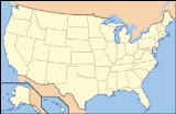
Sleeping Bear Dunes National Lakeshore is a United States National Lakeshore
located along the northwest coast of the Lower Peninsula
of Michigan
in Leelanau County
and Benzie County
.
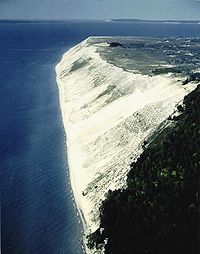
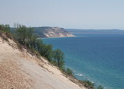
The park covers a 35-mile (60-km) stretch of Lake Michigan
's eastern coastline, as well as North
and South Manitou Island
s. This northern Michigan
park was established primarily because of its outstanding natural features, including forests, beaches, dune formations, and ancient glacial phenomena. The Lakeshore also contains many cultural features including the 1871 South Manitou Island Lighthouse, three former Life-Saving Service/Coast Guard
Stations and an extensive rural historic farm district.
 The park was authorized on October 21, 1970. The park's creation was highly controversial because it involved the transfer of private property to public. The Federal government's stance at the time was that the Great Lakes were the "third coast" and had to be preserved much like Cape Hatteras
or Big Sur
, which are National Seashores. The residents living in what is now Sleeping Bear Dunes National Lakeshore believed they were stewards of the land and did not want it to be overrun by tourists. The Government eventually won out in part by supporting the local schools to offset the lost property tax revenue and by adding North Manitou Island
to be included in the park.
The park is named after a Chippewa legend of the sleeping bear. According to the legend, an enormous forest fire on the western shore of Lake Michigan
drove a mother bear and her two cubs into the lake for shelter, determined to reach the opposite shore. After many miles of swimming, the two cubs lagged behind. When the mother bear reached the shore, she waited on the top of a high bluff. The exhausted cubs drowned in the lake, but the mother bear stayed and waited in hopes that her cubs would finally appear. Impressed by the mother bear's determination and faith, the Great Spirit
created two islands (North
and South Manitou Island
) to commemorate the cubs, and the winds buried the sleeping bear under the sands of the dunes where she waits to this day. The "bear" was a small tree-covered knoll at the top edge of the bluff that, from the water, had the appearance of a sleeping bear. Wind and erosion have caused the "bear" to be greatly reduced in size over the years. Today only a small remnant remains.
In 2011, the park was named by ABC's Good Morning America as the "Most Beautiful Place in America".
Platte Plains - 14.7 miles (23.7 km) of trails looping over a mostly flat plain.
Empire Bluff - A short trail of only 1.5 miles (2.4 km) round trip, but a very hilly trip that winds through an old beech-maple forest
to the lookout atop of Empire Bluff;
Windy Moraine- A 1.5 miles (2.4 km) trail with one big hill that has a good view of Glen Lake
;
Shauger Hill- A 2.4 miles (3.9 km) loop with some very steep hills and crosses the Scenic Drive a couple of times;
Cottonwood (not maintained for skiing);
The Dunes (not maintained for skiing);
Duneside Accessible (not maintained for skiing);
The Dunes (Sleeping Bear Point) (not maintained for skiing);
Alligator Hill-Two long and steep hills that end in a beautiful 180 degree view of the surrounding forests and Lake Michigan
Bay View;
Pyramid Point (not maintained for skiing);
Good Harbor Bay;
. In the early days of shipping on the lakes, any change in direction had the potential for accidents. And here, it was compounded by a shoreline that continues northward along the shipping routes, and two islands set several miles out from the shore, South Manitou Island
and North Manitou Island
In rough weather, Manitou passage offered safety. The Life-Saving Service established a station out on the point in 1871 and operated until 1915. At that time, Service became the root of a new organization, the U.S. Coast Guard. The original station is now a museum, along with the Boathouse, Surfboats, and Beach Apparatus (Breeches Buoy).
or Eastern cougar
s have been observed in the Lakeshore, and the National Park Service advises respect, caution and notification to rangers if one is encountered.
United States National Lakeshore
The United States has ten protected areas known as national seashores and four known as national lakeshores, which are operated by the National Park Service, an agency of the Department of the Interior. National seashores and lakeshores must be established by an act of the United States Congress...
located along the northwest coast of the Lower Peninsula
Lower Peninsula of Michigan
The Lower Peninsula of Michigan is the southern of the two major landmasses of the U.S. state of Michigan. It is surrounded by water on all sides except its southern border, which it shares with Ohio and Indiana. Geographically, the Lower Peninsula has a recognizable shape that many people...
of Michigan
Michigan
Michigan is a U.S. state located in the Great Lakes Region of the United States of America. The name Michigan is the French form of the Ojibwa word mishigamaa, meaning "large water" or "large lake"....
in Leelanau County
Leelanau County, Michigan
-History:The county's name is said to be a Native American word meaning "delight of life", but it is a neologism made up by Indian agent and ethnographer Henry Schoolcraft, who sometimes gave the name "Leelinau" to Native American women in his tales. He created many faux Indian place names in...
and Benzie County
Benzie County, Michigan
-Demographics:As of the 2000 census, there were 15,998 people, 6,500 households, and 4,595 families residing in the county. The population density was 50 people per square mile . There were 10,312 housing units at an average density of 32 per square mile...
.
The park covers a 35-mile (60-km) stretch of Lake Michigan
Lake Michigan
Lake Michigan is one of the five Great Lakes of North America and the only one located entirely within the United States. It is the second largest of the Great Lakes by volume and the third largest by surface area, after Lake Superior and Lake Huron...
's eastern coastline, as well as North
North Manitou Island
North Manitou Island is located in Lake Michigan, approximately west-northwest of Leland, Michigan. It is nearly eight miles long and over four miles wide, with of shoreline. It has a land area of 57.876 km² and has no population...
and South Manitou Island
South Manitou Island
South Manitou Island is located in Lake Michigan, approximately west of Leland, Michigan. It is part of Leelanau County and the Sleeping Bear Dunes National Lakeshore. The uninhabited island is in land area and can be accessed by a ferry service from Leland...
s. This northern Michigan
Northern Michigan
Northern Michigan, also known as Northern Lower Michigan , is a region of the U.S. state of Michigan...
park was established primarily because of its outstanding natural features, including forests, beaches, dune formations, and ancient glacial phenomena. The Lakeshore also contains many cultural features including the 1871 South Manitou Island Lighthouse, three former Life-Saving Service/Coast Guard
United States Coast Guard
The United States Coast Guard is a branch of the United States Armed Forces and one of the seven U.S. uniformed services. The Coast Guard is a maritime, military, multi-mission service unique among the military branches for having a maritime law enforcement mission and a federal regulatory agency...
Stations and an extensive rural historic farm district.
History
Cape Hatteras
Cape Hatteras is a cape on the coast of North Carolina. It is the point that protrudes the farthest to the southeast along the northeast-to-southwest line of the Atlantic coast of North America...
or Big Sur
Big Sur
Big Sur is a sparsely populated region of the Central Coast of California where the Santa Lucia Mountains rise abruptly from the Pacific Ocean. The name "Big Sur" is derived from the original Spanish-language "el sur grande", meaning "the big south", or from "el país grande del sur", "the big...
, which are National Seashores. The residents living in what is now Sleeping Bear Dunes National Lakeshore believed they were stewards of the land and did not want it to be overrun by tourists. The Government eventually won out in part by supporting the local schools to offset the lost property tax revenue and by adding North Manitou Island
North Manitou Island
North Manitou Island is located in Lake Michigan, approximately west-northwest of Leland, Michigan. It is nearly eight miles long and over four miles wide, with of shoreline. It has a land area of 57.876 km² and has no population...
to be included in the park.
The park is named after a Chippewa legend of the sleeping bear. According to the legend, an enormous forest fire on the western shore of Lake Michigan
Lake Michigan
Lake Michigan is one of the five Great Lakes of North America and the only one located entirely within the United States. It is the second largest of the Great Lakes by volume and the third largest by surface area, after Lake Superior and Lake Huron...
drove a mother bear and her two cubs into the lake for shelter, determined to reach the opposite shore. After many miles of swimming, the two cubs lagged behind. When the mother bear reached the shore, she waited on the top of a high bluff. The exhausted cubs drowned in the lake, but the mother bear stayed and waited in hopes that her cubs would finally appear. Impressed by the mother bear's determination and faith, the Great Spirit
Chippewa mythology
Anishinaabe traditional beliefs cover the traditional belief system of the Anishinaabeg peoples, consisting of the Algonquin/Nipissing, Ojibwa/Chippewa/Saulteaux/Mississaugas, Odawa, Potawatomi and Oji-cree, located primarily in the Great Lakes region of the United States and Canada.-Medicine...
created two islands (North
North Manitou Island
North Manitou Island is located in Lake Michigan, approximately west-northwest of Leland, Michigan. It is nearly eight miles long and over four miles wide, with of shoreline. It has a land area of 57.876 km² and has no population...
and South Manitou Island
South Manitou Island
South Manitou Island is located in Lake Michigan, approximately west of Leland, Michigan. It is part of Leelanau County and the Sleeping Bear Dunes National Lakeshore. The uninhabited island is in land area and can be accessed by a ferry service from Leland...
) to commemorate the cubs, and the winds buried the sleeping bear under the sands of the dunes where she waits to this day. The "bear" was a small tree-covered knoll at the top edge of the bluff that, from the water, had the appearance of a sleeping bear. Wind and erosion have caused the "bear" to be greatly reduced in size over the years. Today only a small remnant remains.
In 2011, the park was named by ABC's Good Morning America as the "Most Beautiful Place in America".
Trails
Old Indian Trail - Two mostly flat loops of about 2.5 miles (4 km) each that takes hikers/skiers to the shore of Lake Michigan;Platte Plains - 14.7 miles (23.7 km) of trails looping over a mostly flat plain.
Empire Bluff - A short trail of only 1.5 miles (2.4 km) round trip, but a very hilly trip that winds through an old beech-maple forest
Beech-maple forest
A beech-maple forest is a climax mesic closed canopy hardwood forest. It is primarily composed of American Beech and Sugar Maple trees which co-dominate the forest and which are the pinnacle of plant succession in their range...
to the lookout atop of Empire Bluff;
Windy Moraine- A 1.5 miles (2.4 km) trail with one big hill that has a good view of Glen Lake
Glen Lake
Glen Lake is a lake located in Leelanau County in the U.S. state of Michigan, near Lake Michigan. Several villages and hamlets lie along or near its shore, including Burdickville, Glen Arbor, and Glen Haven...
;
Shauger Hill- A 2.4 miles (3.9 km) loop with some very steep hills and crosses the Scenic Drive a couple of times;
Cottonwood (not maintained for skiing);
The Dunes (not maintained for skiing);
Duneside Accessible (not maintained for skiing);
The Dunes (Sleeping Bear Point) (not maintained for skiing);
Alligator Hill-Two long and steep hills that end in a beautiful 180 degree view of the surrounding forests and Lake Michigan
Bay View;
Pyramid Point (not maintained for skiing);
Good Harbor Bay;
Pierce Stocking Scenic Drive
Pierce Stocking Scenic Drive is a 7.5 miles (12.1 km) loop that overlooks some of the Lakeshore's most unique scenery. There is an observation point that is atop of a 450 feet (137.2 m) bluff and looks straight down at Lake Michigan and north one mile (1.6 km) to the Sleeping Bear Dune. The Sleeping Bear Dune and The Manitou Islands can be seen from the overlooks at stops #3,9, and 10. At stop #4, one can hike a 1.5 miles (2.4 km) loop through the perched dunes called the Cottonwood Trail. In mid-November, the drive is close to vehicular traffic and is used as a cross-country ski trail.Historic sites
Sleeping Bear Point Coast Guard Station Maritime Museum
Out from Sleeping Bear Point, the shipping lanes turn towards the east and the Straits of MackinacStraits of Mackinac
The Straits of Mackinac is the strip of water that connects two of the Great Lakes, Lake Michigan and Lake Huron, and separates the Lower Peninsula of Michigan from the Upper Peninsula of Michigan. It is a shipping lane providing passage for raw materials and finished goods, connecting, for...
. In the early days of shipping on the lakes, any change in direction had the potential for accidents. And here, it was compounded by a shoreline that continues northward along the shipping routes, and two islands set several miles out from the shore, South Manitou Island
South Manitou Island
South Manitou Island is located in Lake Michigan, approximately west of Leland, Michigan. It is part of Leelanau County and the Sleeping Bear Dunes National Lakeshore. The uninhabited island is in land area and can be accessed by a ferry service from Leland...
and North Manitou Island
North Manitou Island
North Manitou Island is located in Lake Michigan, approximately west-northwest of Leland, Michigan. It is nearly eight miles long and over four miles wide, with of shoreline. It has a land area of 57.876 km² and has no population...
In rough weather, Manitou passage offered safety. The Life-Saving Service established a station out on the point in 1871 and operated until 1915. At that time, Service became the root of a new organization, the U.S. Coast Guard. The original station is now a museum, along with the Boathouse, Surfboats, and Beach Apparatus (Breeches Buoy).
Glen Haven Village
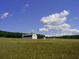
Glen Haven existed as a company town from 1865-1931. Originally, a dock for Glen Arbor (1855-date), the site soon became a fuel supply point for ships traveling up and down the lake. Here Charles McCarty decided to open his own business and built a dock to supply the ships with wood. In 1863, McCarty built the Sleeping Bear House. It was expanded a few years later to accommodate travelers. In 1928, it was remodeled into the Inn for summer vacationers. The General Store was established to supply the workers. Like most company towns, the workers were paid in company coupons, redeemable only at the company store. The Blacksmith Shop is where tools were repaired. In 1878, David Henry Day arrived in the community. By this time, coal from the Appalachian coal fields was replacing wood on the steamships. Day was looking for another future to this small community.Port Oneida Historic Farm District
In 1860, Port Oneida had a population of 87 people. Thomas Kelderhouse had built a dock to sell wood to the passing steamships. He was also able to sell fresh produce and maple sugar in season. A local story says that the name comes from the first ship to stop, the S.S. Oneida of New York State. The area covers 3000 acres (12.1 km²) and includes 16 historic farms. The farming community was gradually abandoned due to hard farming conditions and declining timber sales.Climate
Flora and fauna
CougarsCougars
Cougars is a Chicago-based rock band signed to the New York-based label Go-Kart Records.The Cougars' music is often compared to that of Rocket from the Crypt...
or Eastern cougar
Eastern Cougar
The North American Cougar , is the cougar subspecies once commonly found in eastern North America and still prevalent in the western half of the continent...
s have been observed in the Lakeshore, and the National Park Service advises respect, caution and notification to rangers if one is encountered.
See also
- Sand Dune
- National Park ServiceNational Park ServiceThe National Park Service is the U.S. federal agency that manages all national parks, many national monuments, and other conservation and historical properties with various title designations...
- Pierce Stocking Scenic DrivePierce Stocking Scenic DriveThe Pierce Stocking Scenic Drive is a scenic route within Sleeping Bear Dunes National Lakeshore, in western Northern Michigan in the United States. The roadway, with its "scenic vistas and gentle curves", is located off state highway M-109 between Empire and Glen Arbor...
- Port Oneida Rural Historic DistrictPort Oneida Rural Historic DistrictPort Oneida Rural Historic District is part of the Sleeping Bear Dunes National Lakeshore. It consists of a set of farms in the Leelanau Peninsula of Northern Michigan that are typical of Northern European settlers throughout the Midwestern United States in the later part of the 19th century.The...
- List of areas in the National Park System of the United States
- Glen Haven, MichiganGlen Haven, MichiganGlenn Haven is a restored logging village on the shore of Lake Michigan on the Leelanau Peninsula within the Sleeping Bear Dunes National Lakeshore. Attractions include the restored General Store and Blacksmith Shop. The unincorporated community is located in Glen Arbor Township.Also located in...