
Mojave National Preserve
Encyclopedia
Mojave Desert
The Mojave Desert occupies a significant portion of southeastern California and smaller parts of central California, southern Nevada, southwestern Utah and northwestern Arizona, in the United States...
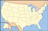
of San Bernardino County, California
San Bernardino County, California
San Bernardino County is a county in the U.S. state of California. As of the 2010 census, the population was 2,035,210, up from 1,709,434 as of the 2000 census...
, USA, between Interstate 15
Interstate 15 in California
In the U.S. state of California, Interstate 15 is a major north–south route through the San Bernardino, Riverside, and San Diego Counties, and it has a length of in the state. It is a major thoroughfare for traffic between Southern California and Las Vegas, Nevada, as well as points beyond...
and Interstate 40
Interstate 40
Interstate 40 is the third-longest major east–west Interstate Highway in the United States, after I-90 and I-80. Its western end is at Interstate 15 in Barstow, California; its eastern end is at a concurrency of U.S. Route 117 and North Carolina Highway 132 in Wilmington, North Carolina...
. The preserve was established October 31, 1994 with the passage of the California Desert Protection Act by the US Congress. Previously, it was the East Mojave National Scenic Area, under the jurisdiction of the Bureau of Land Management
Bureau of Land Management
The Bureau of Land Management is an agency within the United States Department of the Interior which administers America's public lands, totaling approximately , or one-eighth of the landmass of the country. The BLM also manages of subsurface mineral estate underlying federal, state and private...
.
Natural features include the Kelso Dunes
Kelso Dunes
Kelso Dunes, also known as the Kelso Dune Field, is the largest field of eolian sand deposits in the Mojave Desert. The region is protected by the Mojave National Preserve and is located near the town of Baker, San Bernardino County, California and the Preserve Visitor Center...
, the Marl Mountains
Marl Mountains
The Marl Mountains are located in the Mojave National Preserve in eastern California in the United States, northeast of the Kelso Mountains. The Marl Mountains lie just east of Kelbaker Road, which connects the town of Baker with the small community of Kelso, California.Like the Beale Mountains to...
and the Cima Dome
Cima Dome & Volcanic Field National Natural Landmark
The Cima Dome & Volcanic Field National Natural Landmark, or Cinder Cones National Natural Landmark, includes the Cima Dome, Cima Volcanic Field, and Cima Volcanic Range, and is in the Mojave Desert within San Bernardino County, California, United States.The dome and volcanic field with cinder...
, as well as volcanic
Volcano
2. Bedrock3. Conduit 4. Base5. Sill6. Dike7. Layers of ash emitted by the volcano8. Flank| 9. Layers of lava emitted by the volcano10. Throat11. Parasitic cone12. Lava flow13. Vent14. Crater15...
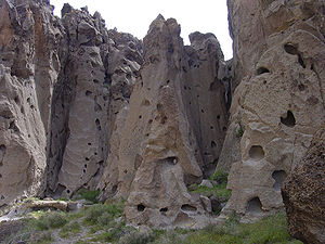
formations such as Hole-in-the-Wall and the Cinder Cone Lava Beds. The preserve encloses Providence Mountains State Recreation Area
Providence Mountains State Recreation Area
The Providence Mountains State Recreation Area is located in the Providence Mountains, within the Mojave National Preserve in San Bernardino County, California...
and Mitchell Caverns Natural Preserve
Mitchell Caverns
The Mitchell's Caverns, within the Mitchell Caverns Natural Preserve, are a trio of limestone caves, located on the east side of the Providence Mountains at an elevation of 4300 ft , within the Providence Mountains State Recreation Area...
, which are both managed by the California Department of Parks and Recreation
California Department of Parks and Recreation
The California Department of Parks and Recreation, also known as California State Parks, manages the California state parks system. The system administers 278 parks and 1.4 million acres , with over of coastline; of lake and river frontage; nearly 15,000 campsites; and of hiking, biking, and...
.
Impressive Joshua Tree forests cover parts of the preserve. The Cima Dome and Shadow Valley forests are the largest in the world. The defunct railroad depot
Kelso Depot, Restaurant and Employees Hotel
The Kelso Depot, Restaurant and Employees Hotel or Kelso Depot, now also the Mojave National Preserve Visitors Center, is located in the Mojave Desert within the National Park Service Mojave National Preserve, on Kelbaker Road in Kelso, California, between Baker and Interstate 15 to the north and...
and ghost town
Ghost town
A ghost town is an abandoned town or city. A town often becomes a ghost town because the economic activity that supported it has failed, or due to natural or human-caused disasters such as floods, government actions, uncontrolled lawlessness, war, or nuclear disasters...
of Kelso
Kelso, California
Kelso is a ghost town and defunct railroad depot in the Mojave National Preserve in San Bernardino County, California, USA. It was named after a railroad worker who won a contest to have the town named after him...
are also found there. The depot is now the visitor center. The preserve is commonly traversed by 4 wheel drive vehicles traveling on the historic Mojave Road
Mojave Road
The Mojave Road or Mojave Trail is a historic route and present day 'four-wheel drive road' across what is now the Mojave National Preserve in the Mojave Desert of California, United States.-History:...
.
The climate varies greatly. Summer temperatures average 90 °F (32.2 °C), with highs exceeding 105 °F (40.6 °C). Elevations in the Preserve range from 7929 feet (2,416.8 m) at Clark Mountain
Clark Mountain (California)
Clark Mountain is a mountain located in the Clark Mountain Range in the Mojave National Preserve, close to the California-Nevada border.-Geography:...
to 880 feet (268.2 m) near Baker. Annual precipitation varies from 3.37 inches (85.6 mm) near Baker, to almost 9 inches (228.6 mm) in the mountains. At least 25% of precipitation comes from summer thunderstorms. Snow is often found in the mountains during the winter.
Mojave Wilderness
The California Desert Protection Act of 1994California Desert Protection Act of 1994
The California Desert Protection Act of 1994 is a federal law , signed by President Bill Clinton, and passed by the United States Congress on October 8, 1994, that established the Death Valley and Joshua Tree National Parks and the Mojave National Preserve in the California...
(CDPA) designated a wilderness area within Mojave National Preserve of approximately 695200 acres (281,337.7 ha). The National Park Service manages the wilderness in accordance with the Wilderness Act
Wilderness Act
The Wilderness Act of 1964 was written by Howard Zahniser of The Wilderness Society. It created the legal definition of wilderness in the United States, and protected some 9 million acres of federal land. The result of a long effort to protect federal wilderness, the Wilderness Act was signed...
, the CDPA, and other laws that protect cultural and historic sites in the wilderness.
Features
- Beale MountainsBeale MountainsThe Beale Mountains are located in the Mojave National Preserve in eastern California. The range is one of the smallest mountain ranges in the United States, and is only about 2.5 miles long. The mountains are located northeast of the Kelso Mountains, about five miles from the Kelso Cima road, in...
- Cima, CaliforniaCima, CaliforniaCima is a small unincorporated community in the Mojave Desert of San Bernardino County, California, in the United States. Few people live in the area...
- Cima Dome & Volcanic Field National Natural LandmarkCima Dome & Volcanic Field National Natural LandmarkThe Cima Dome & Volcanic Field National Natural Landmark, or Cinder Cones National Natural Landmark, includes the Cima Dome, Cima Volcanic Field, and Cima Volcanic Range, and is in the Mojave Desert within San Bernardino County, California, United States.The dome and volcanic field with cinder...
- Clark MountainClark Mountain (California)Clark Mountain is a mountain located in the Clark Mountain Range in the Mojave National Preserve, close to the California-Nevada border.-Geography:...
- Devils PlaygroundDevils PlaygroundThe Devils Playground is a large sandy region in the Mojave Desert in the state of California in the United States. Dunes and salt flats stretch for approximately 40 miles in a generally northwest-southeasterly direction in the Mojave National Preserve. The Cronese Mountains are located at its...
- Granite MountainsGranite Mountains (California)The Granite Mountains is a small mountain range in San Bernardino County, California, USA, located in the Mojave Desert.They are in the Mojave National Preserve, in the National Park Service system.-Geography:...
- Ivanpah, CaliforniaIvanpah, CaliforniaIvanpah was a short-lived silver mining town located in San Bernardino County, California, United States. It was founded in 1869, and existed until at least the mid-1880s...
- Ivanpah MountainsIvanpah MountainsThe Ivanpah Mountains are located in the southeastern Mojave Desert of California in the United States. The range lies to the south and east of the Mescal Range and west of the Ivanpah Valley and New York Mountains. The mountains lie in a southwest-northeasterly direction, and are home to the...
- Kelso, CaliforniaKelso, CaliforniaKelso is a ghost town and defunct railroad depot in the Mojave National Preserve in San Bernardino County, California, USA. It was named after a railroad worker who won a contest to have the town named after him...
- Kelso DepotKelso Depot, Restaurant and Employees HotelThe Kelso Depot, Restaurant and Employees Hotel or Kelso Depot, now also the Mojave National Preserve Visitors Center, is located in the Mojave Desert within the National Park Service Mojave National Preserve, on Kelbaker Road in Kelso, California, between Baker and Interstate 15 to the north and...
- Kelso DunesKelso DunesKelso Dunes, also known as the Kelso Dune Field, is the largest field of eolian sand deposits in the Mojave Desert. The region is protected by the Mojave National Preserve and is located near the town of Baker, San Bernardino County, California and the Preserve Visitor Center...
- Kelso MountainsKelso MountainsThe Kelso Mountains are located just north of the small community of Kelso and the Kelso Dunes, in the Mojave National Preserve in southeastern California. The town of Baker, near Interstate 15, lies approximately 18 miles to the northwest of the mountain range. Kelso Peak, at 4,764 feet , is the...
- Lanfair ValleyLanfair ValleyLanfair Valley is located in the Mojave Desert in southeastern California near the Nevada state line. It is bounded on the north by the New York Mountains and Castle Mountains, on the east by the Piute Range, and on the south by the Woods Mountains and Vontrigger Hills. Joshua Trees can be found in...
- Marl MountainsMarl MountainsThe Marl Mountains are located in the Mojave National Preserve in eastern California in the United States, northeast of the Kelso Mountains. The Marl Mountains lie just east of Kelbaker Road, which connects the town of Baker with the small community of Kelso, California.Like the Beale Mountains to...
- Mid HillsMid HillsThe Mid Hills are a low mountain range in the Mojave Desert, in San Bernardino County, California. The Mid Hills are located entirely within Mojave National Preserve....
- Mojave phone boothMojave phone boothThe Mojave phone booth was a lone telephone booth in what is now the Mojave National Preserve in California, which attracted online attention in 1997 due to its unusual location. Placed in the 1960s, the booth was eight miles from the nearest paved road, fifteen miles from the nearest numbered...
- Mojave RoadMojave RoadThe Mojave Road or Mojave Trail is a historic route and present day 'four-wheel drive road' across what is now the Mojave National Preserve in the Mojave Desert of California, United States.-History:...
- New York MountainsNew York MountainsThe New York Mountains are found in northeastern San Bernardino County in California, USA; the range's northeast lies in southeast Nevada. The range lies just south of the small community of Ivanpah, and north of the Lanfair Valley. The mountains are part of the mountain ranges, cones, mountains,...
- Providence, CaliforniaProvidence, CaliforniaProvidence was a short-lived silver mining town located in San Bernardino County, California, United States. It existed between 1880 and 1886.-Location:The town of Providence was located on the east slope of the Providence Mountains...
- Providence MountainsProvidence MountainsThe Providence Mountains are found in the eastern Mojave Desert of San Bernardino County, California, U.S. The range reaches an elevation of at Edgar Peak and is home to the Mitchell Caverns Natural Preserve in the Providence Mountains State Recreation Area, and the Mojave National...
- Vanderbilt, CaliforniaVanderbilt, CaliforniaVanderbilt was a short-lived gold mining town located in San Bernardino County, California, United States. It existed between 1893 and 1895. At its peak it may have had a population of about 400 people.-Location:...
- Vontrigger HillsVontrigger HillsThe Vontrigger Hills are a mountain range in the Mojave Desert, in eastern San Bernardino County, California.Vontrigger Hills is located in Mojave National Preserve, approximately ten miles north of the small settlement of Goffs, California on U.S. Route 66....
See also
- Mojave Memorial CrossMojave Memorial CrossThe Mojave Memorial Cross is a cross formerly on public land in the Mojave desert that was at the center of the Salazar v. Buono legal case before the U.S. Supreme Court. The original cross was erected in 1934 to honor those killed in war. The cross has been maintained by volunteers and was...
Mojave National Preserve index List