
Skyline Drive
Encyclopedia
- This article refers to the road in Shenandoah National Park in Virginia. For the park itself, see Shenandoah National ParkShenandoah National ParkShenandoah National Park encompasses part of the Blue Ridge Mountains in the U.S. state of Virginia. This national park is long and narrow, with the broad Shenandoah River and valley on the west side, and the rolling hills of the Virginia Piedmont on the east...
. For other roads named Skyline Drive, see Skyline Drive (disambiguation)Skyline Drive (disambiguation)There are several roads named Skyline Drive:* Skyline Drive, in Shenandoah National Park in Virginia, USA* Skyline Drive , in the Ramapo Mountains between Ringwood in Passaic County, New Jersey and Oakland in Bergen County, New Jersey...
.
Skyline Drive is a 105-mile (169-km) road that runs the entire length of the National Park Service's
National Park Service
The National Park Service is the U.S. federal agency that manages all national parks, many national monuments, and other conservation and historical properties with various title designations...
Shenandoah National Park
Shenandoah National Park
Shenandoah National Park encompasses part of the Blue Ridge Mountains in the U.S. state of Virginia. This national park is long and narrow, with the broad Shenandoah River and valley on the west side, and the rolling hills of the Virginia Piedmont on the east...
in the Blue Ridge Mountains
Blue Ridge Mountains
The Blue Ridge Mountains are a physiographic province of the larger Appalachian Mountains range. This province consists of northern and southern physiographic regions, which divide near the Roanoke River gap. The mountain range is located in the eastern United States, starting at its southern-most...
of Virginia
Virginia
The Commonwealth of Virginia , is a U.S. state on the Atlantic Coast of the Southern United States. Virginia is nicknamed the "Old Dominion" and sometimes the "Mother of Presidents" after the eight U.S. presidents born there...
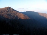
, generally along the ridge of the mountains. The scenic drive is particularly popular in the fall when the leaves are changing colors. Annually, over two million people visit the Skyline Drive, which has been designated a National Scenic Byway
National Scenic Byway
A National Scenic Byway is a road recognized by the United States Department of Transportation for its archeological, cultural, historic, natural, recreational, and/or scenic qualities. The program was established by Congress in 1991 to preserve and protect the nation's scenic but often...
.
Entry
Major entry points to Skyline Drive are as follows:- Front Royal, VirginiaFront Royal, VirginiaFront Royal is a town in Warren County, Virginia, United States. The population was 13,589 at the 2000 census. It is the county seat of Warren County.-Geography:Front Royal is roughly west of Washington, D.C....
(U.S. Highway 340), the northern terminus - Thornton GapThornton GapThornton Gap is a wind gap located in the Blue Ridge Mountains in Virginia separating the Shenandoah Valley from the Piedmont region of the state.-History:...
(U.S. Highway 211) - Swift Run GapSwift Run GapSwift Run Gap is a wind gap in the Blue Ridge Mountains located in the U.S. state of Virginia.-Geography:At an elevation of , it is the site of the mountain crossing of U.S...
(U.S. Highway 33) - Rockfish GapRockfish GapRockfish Gap is a wind gap located in the Blue Ridge Mountains between Charlottesville and Waynesboro, Virginia, United States, through Afton Mountain, which is frequently used to refer to the gap....
(Interstate 64Interstate 64Interstate 64 is an Interstate Highway in the Midwestern and Southeastern United States. Its western terminus is at I-70, U.S. 40, and U.S. 61 in Wentzville, Missouri. Its eastern terminus is at an interchange with I-264 and I-664 at Bowers Hill in Chesapeake, Virginia. As I-64 is concurrent with...
, U.S. Highway 250), the southern terminus.
As of October 2011, the entry fee for all vehicles is $15 for a single car, and $10 for motorcycles. The fee varies based on the season. Passes, which are valid for unlimited entries within a seven-day period, are issued. Payment may be made with cash
Cash
In common language cash refers to money in the physical form of currency, such as banknotes and coins.In bookkeeping and finance, cash refers to current assets comprising currency or currency equivalents that can be accessed immediately or near-immediately...
, credit
Credit card
A credit card is a small plastic card issued to users as a system of payment. It allows its holder to buy goods and services based on the holder's promise to pay for these goods and services...
, or debit card
Debit card
A debit card is a plastic card that provides the cardholder electronic access to his or her bank account/s at a financial institution...
s. A year-long pass can be purchased for $30 (A Season Pass will admit 2 motorcycles).
Mileposts
On the west side (right when traveling from north to south) of the drive, mileposts are present. They are numbered from 0 to 105 (north to south). These are the reference points to directions in the drive.Driving precautions
The speed limitSpeed limit
Road speed limits are used in most countries to regulate the speed of road vehicles. Speed limits may define maximum , minimum or no speed limit and are normally indicated using a traffic sign...
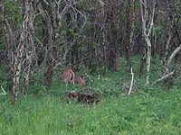
is 35 miles per hour (60 km/h), due to curves, wildlife and tourists. One might see stopped vehicles in the road either enjoying the wildlife or just turning to stop at an overlook. Bicycles, vehicles and pedestrians share the road. There are also deer, bear, and other wildlife crossing the road which may appear without warning. These all require extra precaution. The speed limit within the park is strictly enforced by park police.
Experience
Blue Ridge Mountains
The Blue Ridge Mountains are a physiographic province of the larger Appalachian Mountains range. This province consists of northern and southern physiographic regions, which divide near the Roanoke River gap. The mountain range is located in the eastern United States, starting at its southern-most...
east of the Shenandoah River
Shenandoah River
The Shenandoah River is a tributary of the Potomac River, long with two forks approximately long each, in the U.S. states of Virginia and West Virginia...
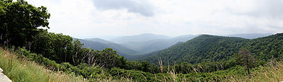
. There are nearly seventy-five overlooks throughout the drive, giving some of the most spectacular views of the surrounding valleys. During the drive (especially in early morning and late evening) wildlife can be seen on the road. Interestingly, Shenandoah National Park
Shenandoah National Park
Shenandoah National Park encompasses part of the Blue Ridge Mountains in the U.S. state of Virginia. This national park is long and narrow, with the broad Shenandoah River and valley on the west side, and the rolling hills of the Virginia Piedmont on the east...
has one of the densest populations of black bears documented within the U.S.
Apart from the drive, one can hike and camp. There are numerous trails throughout, including a portion of the Appalachian Trail
Appalachian Trail
The Appalachian National Scenic Trail, generally known as the Appalachian Trail or simply the AT, is a marked hiking trail in the eastern United States extending between Springer Mountain in Georgia and Mount Katahdin in Maine. It is approximately long...
, which follows the road's path. Biking and horseback riding are other recreational activities which are allowed on the road. There are also visitors centers, cabins for rent, and even restaurants (the one at the Skyland Lodge gives diners a spectacular vista of the valley south of Luray
Luray, Virginia
Luray is a town in Page County, Virginia, United States, in the Shenandoah Valley of the northern part of the state. It is also the county seat...
).
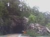
There is a tunnel
Tunnel
A tunnel is an underground passageway, completely enclosed except for openings for egress, commonly at each end.A tunnel may be for foot or vehicular road traffic, for rail traffic, or for a canal. Some tunnels are aqueducts to supply water for consumption or for hydroelectric stations or are sewers...
named "Mary's Rock Tunnel" at mile 31 of the drive. The clearance is 12'8" (3.8 m). It is 670 feet (203 m) long.
At Rockfish Gap, the Blue Ridge Parkway
Blue Ridge Parkway
The Blue Ridge Parkway is a National Parkway and All-American Road in the United States, noted for its scenic beauty. It runs for 469 miles , mostly along the famous Blue Ridge, a major mountain chain that is part of the Appalachian Mountains...
begins, and continues a similar path along ridge tops through Virginia and into North Carolina
North Carolina
North Carolina is a state located in the southeastern United States. The state borders South Carolina and Georgia to the south, Tennessee to the west and Virginia to the north. North Carolina contains 100 counties. Its capital is Raleigh, and its largest city is Charlotte...
, terminating at Great Smoky Mountains National Park
Great Smoky Mountains National Park
Great Smoky Mountains National Park is a United States National Park and UNESCO World Heritage Site that straddles the ridgeline of the Great Smoky Mountains, part of the Blue Ridge Mountains, which are a division of the larger Appalachian Mountain chain. The border between Tennessee and North...
. Though the land immediately around the parkway is protected by the National Park Service, much of the parkway goes near private land, but it is, nonetheless, quite rustic and charming.
History
- Further information:History of Shenandoah National Park
Works Progress Administration
The Works Progress Administration was the largest and most ambitious New Deal agency, employing millions of unskilled workers to carry out public works projects, including the construction of public buildings and roads, and operated large arts, drama, media, and literacy projects...
(WPA) project during the Great Depression
Great Depression
The Great Depression was a severe worldwide economic depression in the decade preceding World War II. The timing of the Great Depression varied across nations, but in most countries it started in about 1929 and lasted until the late 1930s or early 1940s...
, construction of the Skyline Drive was both difficult and dangerous. Huge cuts were made into the sides of knolls and peaks to allow for a road wide enough to handle traffic. The work began in 1931, and the final section (from Swift Run Gap to Rockfish Gap) was completed and opened in 1939. The Civilian Conservation Corps
Civilian Conservation Corps
The Civilian Conservation Corps was a public work relief program that operated from 1933 to 1942 in the United States for unemployed, unmarried men from relief families, ages 18–25. A part of the New Deal of President Franklin D...
also had a hand in the construction of Skyline Drive. The CCC graded the slopes on both sides of the roadway, built guardrails, constructed overlooks, and planted thousands of trees and shrubs along the parkway.
Since user fees are charged at entry points along the Skyline Drive, the Drive is sometimes mistaken as a toll road
Toll road
A toll road is a privately or publicly built road for which a driver pays a toll for use. Structures for which tolls are charged include toll bridges and toll tunnels. Non-toll roads are financed using other sources of revenue, most typically fuel tax or general tax funds...
. The fee, however, is not a toll charged to drive on the road, but rather to enter, and enjoy, the park. A $15.00 pass is valid for up to seven days (as opposed to charging by the mile, or by the day, as toll roads do).
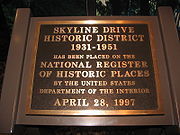
Already a National Scenic Byway
National Scenic Byway
A National Scenic Byway is a road recognized by the United States Department of Transportation for its archeological, cultural, historic, natural, recreational, and/or scenic qualities. The program was established by Congress in 1991 to preserve and protect the nation's scenic but often...
, in October 2008, it was announced that the Skyline Drive was designated a National Historic Landmark
National Historic Landmark
A National Historic Landmark is a building, site, structure, object, or district, that is officially recognized by the United States government for its historical significance...
. It was already inscribed on the National Register of Historic Places
National Register of Historic Places
The National Register of Historic Places is the United States government's official list of districts, sites, buildings, structures, and objects deemed worthy of preservation...
in 1997.
See also
- Appalachian TrailAppalachian TrailThe Appalachian National Scenic Trail, generally known as the Appalachian Trail or simply the AT, is a marked hiking trail in the eastern United States extending between Springer Mountain in Georgia and Mount Katahdin in Maine. It is approximately long...
- Big MeadowsBig MeadowsBig Meadows is a recreational area of the Shenandoah National Park in Madison County and Page County, in the US state of Virginia. The meadow is located on the Skyline Drive at Milepost 51 and contains the park's Harry F. Byrd Visitor Center, a lodge, camp store, and camping area...
- Skyland ResortSkyland ResortSkyland Resort is a hotel and resort in Shenandoah National Park in Virginia.The Skyland Resort, originally called Stony Man Camp, was built in 1895 at what later became the highest point on the Skyline Drive, with a sweeping view of the Shenandoah Valley at 3,680 feet...
- Rapidan CampRapidan CampRapidan Camp in Shenandoah National Park in Madison County, Virginia, was built by U.S. President Herbert Hoover and his wife Lou Henry Hoover, and served as their rustic retreat throughout Hoover's administration from 1929 to 1933...
- Lost counties, cities and towns of Virginia
- Neighbor MountainNeighbor MountainNeighbor Mountain is a mountain in Page and Rappahannock Counties, Virginia, near the city of Luray. It is part of the Blue Ridge Mountains. Its summit lies in Page County, within Shenandoah National Park.-Geology:...
- Blue Ridge ParkwayBlue Ridge ParkwayThe Blue Ridge Parkway is a National Parkway and All-American Road in the United States, noted for its scenic beauty. It runs for 469 miles , mostly along the famous Blue Ridge, a major mountain chain that is part of the Appalachian Mountains...