

Rocky Mountain National Park
Encyclopedia
Rocky Mountain National Park is a national park
located in the north-central region of the U.S. state
of Colorado
.
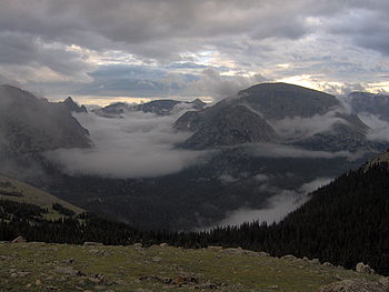
It features majestic mountain
views, a variety of wildlife
, varied climates and environments—from wooded forest
s to mountain tundra
—and easy access to back-country trail
s and campsite
s. The park is located northwest of Boulder, Colorado
, in the Rockies
, and includes the Continental Divide
and the headwaters of the Colorado River.
The park has five visitor centers. The park headquarters, Beaver Meadows Visitor Center, is a National Historic Landmark
, designed by the Frank Lloyd Wright
School of Architecture at Taliesin West
.
The park may be accessed by three roads: U.S. Highway 34, 36, and State Highway 7
. Highway 7 enters the park for less than a mile, where it provides access to the Lily Lake Visitor Center which is closed indefinitely. Farther south, spurs from route 7 lead to campgrounds and trail heads around Longs Peak and Wild Basin. Highway 36 enters the park on the east side, where it terminates after a few miles at Highway 34. Highway 34, known as Trail Ridge Road
through the park, runs from the town of Estes Park
on the east to Grand Lake
on the southwest. The road reaches an elevation of 12183 feet (3,713.4 m), and is closed by snow in winter.
The California Zephyr
serves Granby (near the west entrance of the park) by rail from Denver, crossing the Continental Divide through the Moffat Tunnel
well south of the park. The park's website suggests Granby as an appropriate rail terminus for visitors, although it lies a good sixteen miles from the park without public transportation connections.
The park is surrounded by Roosevelt National Forest
on the north and east, Routt National Forest on the northwest, and Arapaho National Forest
on the southwest.

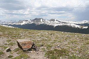 Rocky Mountain National Park encompasses approximately 265770 acres (1,076 km²) of land in Colorado's northern Front Range
. The park is split by the Continental Divide
, which gives the eastern and western portions of the park a different character. The east side of the park tends to be drier, with heavily glaciated
peaks and cirques
. The west side of the park is wetter and more lush, with deep forests dominating.
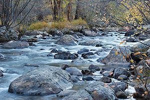
The park contains 359 miles (578 km) of trails, 150 lakes, and 450 miles (724.2 km) of streams. The park contains over 60 named peaks higher than 12000 feet (3,657.6 m), and over one fourth of the park resides above tree line. The highest point of the park is Longs Peak
, which rises to 14,259 feet (4,346 m; surveys before 2002 show 14255 feet (4,344.9 m) http://www.skyrunner.com/story/coheights.htm) above sea level. Longs Peak is the only fourteen thousand foot peak
in the park.
Several small glaciers and permanent snowfields are found in the high mountain cirques, including Andrews Glacier
, Sprague Glacier, Tyndall Glacier
, Taylor Glacier, Rowe Glacier, Mills Glacier, and Moomaw Glacier.
, which prefers drier areas, dominates, though at higher elevations douglas fir trees are found. Above 9,000 feet (2,700 m) the montane forests give way to the subalpine forest. Engelmann Spruce
and Subalpine Fir
trees are common in this zone. These forests tend to have more moisture than the montane and tend to be denser. Above tree line, at approximately 11,500 feet (3,500 m), trees disappear and the vast alpine tundra
takes over. Due to harsh winds and weather, the plants in the tundra are short with very limited growing seasons. Streams have created lush riparian wetlands across the park.
 July and August are the warmest months in the park, where temperatures can reach the 80s although it is not uncommon to drop to below freezing at night. Thunderstorm
s often appear in the afternoons, and visitors should plan on staying below tree line when they occur. Heavy winter snows begin around mid-October, and last into May. While the snow can melt away from the lowest elevations of the park, deep snow is found above 9000 feet (2,743.2 m) in the winter, causing the closure of Trail Ridge and Fall River roads during the winter and spring. Most of the trails are under snow this time of the year, and snowshoeing and skiing
become popular. Springs tend to be wet, alternating between rain and possibly heavy snows. These snows can occur as late as July. The west side of the park typically receives more precipitation than the drier east side.
, which is visible from many vantage points, and has an elevation of 14259 feet (4,346.1 m). Each year thousands of people attempt to scale it. The easiest route is the Keyhole Route, impassable to regular hikers in all but the hottest summer months due to snow and ice. This eight-mile (13 km) one-way climb has an elevation gain of 4850 ft (1,478.3 m). The vast east face, including the area known as The Diamond, is home to many classic big wall rock climbing
routes.
Not all leave Longs Peak alive and safe. There is a stone gazebo at the Keyhole formation with a plaque memorializing Agnes Vaille, a well-known climber in the 1920s. In January 1925, Vaille fell 100 ft (30.5 m) while descending the North Face. Vaille survived the fall with minor injuries, but was unable to walk. Her climbing partner, professional mountaineering guide Walter Kiener, went for help; but when rescuers arrived, Vaille had died of fatigue and hypothermia.
Bear Lake
, in the heart of the park, is a popular destination and trailhead. The lake lies below Hallett Peak
and the Continental Divide. Several trails start from the lake, ranging from easy strolls to strenuous hikes. Bear Lake Road is open year round, though it may close temporarily due to bad weather.
Trail Ridge Road connects the town of Estes Park in the east with Grand Lake
in the west. The road reaches an altitude of 12183 feet (3,713.4 m), with long stretches above tree line. It passes the Alpine Visitors' Center, a popular destination, and crosses the Continental Divide at Milner Pass
. Numerous short interpretive trails and pullouts along the road serve to educate the visitor on the history, geography, and ecology of the park.
The southern area of the park is Wild Basin
, a wild and remote region. Several trails cross the area and backpacking it is popular.
The Mummy Range
is a short mountain range in the north of the park. The Mummies tend to be gentler and more forested than the other peaks in the park, though some slopes are rugged and heavily glaciated, particularly around Ypsilon Mountain and Mummy Mountain
.
The snow-capped Never Summer Mountains
are found in the west side of the park. Here the south-trending Continental Divide takes a brief sharp northward loop, which creates an interesting reverse scenario, where the Pacific Basin is on the east side of the divide and the Atlantic Basin
on the west. The mountains themselves, the result of volcanic activity, are craggy and, more often than not, covered in deep snow. This area saw the most extensive mining in the park, and trails lead past old mines and ghost towns.
Paradise Park is hidden in the peaks above Grand Lake. This rugged and wild area has no trails penetrating it.
have visited the area of the park for the last 10,000 years. Their influence in the region was limited, however, and their visits often transitory. The Ute Tribe
visited the west side of the park, particularly around Grand Lake. The Arapaho
visited and hunted in the Estes Park region.
The Long Expedition, led by Stephen H. Long
, for whom Longs Peak was named, visited the area in 1820, though they never entered the mountains.
Joel Estes and his son stumbled across the meadows that eventually became Estes Park in 1859 while on a hunting expedition. He moved his family there in 1860 and raised cattle. He stayed only until 1866, forced out by long, harsh winters. In the next years, settlers and homesteaders staked their claims in the Estes Park region. Tourists, particularly those interested in climbing the high peaks of the region, appeared after this time.
In 1880 a small mining rush began in the Never Summer Mountains. The mining town of Lulu City was established with great fanfare and promotion by the media, particularly by Fort Collins newspapers. The ore mined, however, was low grade; by 1883 the rush went bust, and most of the residents moved on. A satellite town, Dutchtown, was abandoned by 1884.
Enos Mills
, then a 14 year old boy, moved to Estes Park in 1884. He explored the mountains of the area and wrote many books and articles describing the region. He later supported the creation of Rocky Mountain National Park, and he split his time between the mountains he loved and the cities of the eastern United States, where he lobbied for the legislation to create the park. The legislation was drafted by James Grafton Rogers, a Denver lawyer and avid outdoorsman. Mills' original proposal for park boundaries went from Wyoming
all the way down to the Mount Evans
area, including areas such as the Indian Peaks Wilderness
. Much of the land was favored for mining
, logging
, and other operations, however, so the proposed park was reduced to an area approximating the current park borders. The bill passed Congress and was signed by President Woodrow Wilson
on January 26, 1915. A formal dedication ceremony was held on September 4, 1915 in Horseshoe Park. The park has expanded over the years, with the largest parcel — the Never Summer Range — added in 1929.
The 1920s saw a boom in building lodges and roads in the park, culminating with the construction of Trail Ridge Road between 1929 and 1933. The Civilian Conservation Corps
handled several building projects during the Great Depression
and remnants of their camps can be found in the park today.
On June 24, 2010, a wildfire
burned over 1500 acres (6.1 km²) of the park in Larimer County near Estes Park. Estes Park Fire Department believed that lightning
may have started the fire.
 ]
]
Rocky Mountain National Park was also a place for downhill skiing. Hidden Valley (Ski Estes Park) operated between 1955 - 1991 along U.S. 34, five miles (8 km) west of Estes Park. The area had been skied by locals long before it opened as a ski area
National park
A national park is a reserve of natural, semi-natural, or developed land that a sovereign state declares or owns. Although individual nations designate their own national parks differently A national park is a reserve of natural, semi-natural, or developed land that a sovereign state declares or...
located in the north-central region of the U.S. state
U.S. state
A U.S. state is any one of the 50 federated states of the United States of America that share sovereignty with the federal government. Because of this shared sovereignty, an American is a citizen both of the federal entity and of his or her state of domicile. Four states use the official title of...
of Colorado
Colorado
Colorado is a U.S. state that encompasses much of the Rocky Mountains as well as the northeastern portion of the Colorado Plateau and the western edge of the Great Plains...
.
It features majestic mountain
Mountain
Image:Himalaya_annotated.jpg|thumb|right|The Himalayan mountain range with Mount Everestrect 58 14 160 49 Chomo Lonzorect 200 28 335 52 Makalurect 378 24 566 45 Mount Everestrect 188 581 920 656 Tibetan Plateaurect 250 406 340 427 Rong River...
views, a variety of wildlife
Wildlife
Wildlife includes all non-domesticated plants, animals and other organisms. Domesticating wild plant and animal species for human benefit has occurred many times all over the planet, and has a major impact on the environment, both positive and negative....
, varied climates and environments—from wooded forest
Forest
A forest, also referred to as a wood or the woods, is an area with a high density of trees. As with cities, depending where you are in the world, what is considered a forest may vary significantly in size and have various classification according to how and what of the forest is composed...
s to mountain tundra
Tundra
In physical geography, tundra is a biome where the tree growth is hindered by low temperatures and short growing seasons. The term tundra comes through Russian тундра from the Kildin Sami word tūndâr "uplands," "treeless mountain tract." There are three types of tundra: Arctic tundra, alpine...
—and easy access to back-country trail
Trail
A trail is a path with a rough beaten or dirt/stone surface used for travel. Trails may be for use only by walkers and in some places are the main access route to remote settlements...
s and campsite
Campsite
A campsite or camping pitch is a place used for overnight stay in the outdoors. In British English a campsite is an area, usually divided into a number of pitches, where people can camp overnight using tents or camper vans or caravans; this British English use of the word is synonymous with the...
s. The park is located northwest of Boulder, Colorado
Boulder, Colorado
Boulder is the county seat and most populous city of Boulder County and the 11th most populous city in the U.S. state of Colorado. Boulder is located at the base of the foothills of the Rocky Mountains at an elevation of...
, in the Rockies
Rocky Mountains
The Rocky Mountains are a major mountain range in western North America. The Rocky Mountains stretch more than from the northernmost part of British Columbia, in western Canada, to New Mexico, in the southwestern United States...
, and includes the Continental Divide
Continental Divide
The Continental Divide of the Americas, or merely the Continental Gulf of Division or Great Divide, is the name given to the principal, and largely mountainous, hydrological divide of the Americas that separates the watersheds that drain into the Pacific Ocean from those river systems that drain...
and the headwaters of the Colorado River.
The park has five visitor centers. The park headquarters, Beaver Meadows Visitor Center, is a National Historic Landmark
National Historic Landmark
A National Historic Landmark is a building, site, structure, object, or district, that is officially recognized by the United States government for its historical significance...
, designed by the Frank Lloyd Wright
Frank Lloyd Wright
Frank Lloyd Wright was an American architect, interior designer, writer and educator, who designed more than 1,000 structures and completed 500 works. Wright believed in designing structures which were in harmony with humanity and its environment, a philosophy he called organic architecture...
School of Architecture at Taliesin West
Taliesin West
Taliesin West was architect Frank Lloyd Wright's winter home and school in the desert from 1937 until his death in 1959 at the age of 91. Today it is the main campus of the Frank Lloyd Wright School of Architecture and houses the Frank Lloyd Wright Foundation.Open to the public for tours, Taliesin...
.
The park may be accessed by three roads: U.S. Highway 34, 36, and State Highway 7
Colorado State Highway 7
State Highway 7 in the U.S. state of Colorado is a state highway. Approximately long, it is located in the north-central portion of the state, traversing the mountains on the east of the continental divide south of Estes Park as well as portions of the Colorado Piedmont north of Denver...
. Highway 7 enters the park for less than a mile, where it provides access to the Lily Lake Visitor Center which is closed indefinitely. Farther south, spurs from route 7 lead to campgrounds and trail heads around Longs Peak and Wild Basin. Highway 36 enters the park on the east side, where it terminates after a few miles at Highway 34. Highway 34, known as Trail Ridge Road
Trail Ridge Road
Trail Ridge Road is the name for a stretch of U.S. Highway 34 and is the highest continuous highway in the United States. Also known as Trail Ridge Road/Beaver Meadow National Scenic Byway, it traverses Rocky Mountain National Park from Estes Park, Colorado in the east to Grand Lake, Colorado in...
through the park, runs from the town of Estes Park
Estes Park, Colorado
Estes Park is a town in Larimer County, Colorado, United States. A popular summer resort and the location of the headquarters for Rocky Mountain National Park, Estes Park lies along the Big Thompson River. Estes Park had a population of 5,858 at the 2010 census...
on the east to Grand Lake
Grand Lake, Colorado
The Town of Grand Lake is a Statutory Town located in Grand County, Colorado, United States. The population was 447 at the 2000 census....
on the southwest. The road reaches an elevation of 12183 feet (3,713.4 m), and is closed by snow in winter.
The California Zephyr
California Zephyr
The California Zephyr is a long passenger train route operated by Amtrak in the midwestern and western United States.It runs from Chicago, Illinois, in the east to Emeryville, California, in the west, passing through the states of Illinois, Iowa, Nebraska, Colorado, Utah, Nevada, and California...
serves Granby (near the west entrance of the park) by rail from Denver, crossing the Continental Divide through the Moffat Tunnel
Moffat Tunnel
The Moffat Tunnel is a railroad and water tunnel that cuts through the Continental Divide in north-central Colorado. Named after Colorado railroad pioneer David Moffat, the tunnel's first railroad traffic passed through in February 1928....
well south of the park. The park's website suggests Granby as an appropriate rail terminus for visitors, although it lies a good sixteen miles from the park without public transportation connections.
The park is surrounded by Roosevelt National Forest
Roosevelt National Forest
The Roosevelt National Forest is a National Forest located in north central Colorado. It is contiguous with the Colorado State Forest as well as the Arapaho National Forest...
on the north and east, Routt National Forest on the northwest, and Arapaho National Forest
Arapaho National Forest
Arapaho National Forest is a National Forest located in north-central Colorado, United States. The facility is managed jointly with the Roosevelt National Forest and the Pawnee National Grassland from the United States Forest Service office in Fort Collins, Colorado...
on the southwest.
Geography
Front Range
The Front Range is a mountain range of the Southern Rocky Mountains of North America located in the north-central portion of the U.S. State of Colorado and southeastern portion of the U.S. State of Wyoming. It is the first mountain range encountered moving west along the 40th parallel north across...
. The park is split by the Continental Divide
Continental Divide
The Continental Divide of the Americas, or merely the Continental Gulf of Division or Great Divide, is the name given to the principal, and largely mountainous, hydrological divide of the Americas that separates the watersheds that drain into the Pacific Ocean from those river systems that drain...
, which gives the eastern and western portions of the park a different character. The east side of the park tends to be drier, with heavily glaciated
Glacier
A glacier is a large persistent body of ice that forms where the accumulation of snow exceeds its ablation over many years, often centuries. At least 0.1 km² in area and 50 m thick, but often much larger, a glacier slowly deforms and flows due to stresses induced by its weight...
peaks and cirques
Cirque (landform)
thumb|250 px|Two cirques with semi-permanent snowpatches in [[Abisko National Park]], [[Sweden]].A cirque or corrie is an amphitheatre-like valley head, formed at the head of a valley glacier by erosion...
. The west side of the park is wetter and more lush, with deep forests dominating.
The park contains 359 miles (578 km) of trails, 150 lakes, and 450 miles (724.2 km) of streams. The park contains over 60 named peaks higher than 12000 feet (3,657.6 m), and over one fourth of the park resides above tree line. The highest point of the park is Longs Peak
Longs Peak
Longs Peak is one of the 53 mountains with summits over 14,000 feet in Colorado. It can be prominently seen from Longmont, Colorado, as well as from the rest of the Colorado Front Range. It is named after Major Stephen Long, who explored the area in the 1820s...
, which rises to 14,259 feet (4,346 m; surveys before 2002 show 14255 feet (4,344.9 m) http://www.skyrunner.com/story/coheights.htm) above sea level. Longs Peak is the only fourteen thousand foot peak
Fourteener
In mountaineering terminology in the United States, a fourteener is a mountain that exceeds 14,000 feet above mean sea level. There are 547 fourteeners in the world. The importance of fourteeners is greatest in Colorado, which has the majority of such peaks in North America...
in the park.
Several small glaciers and permanent snowfields are found in the high mountain cirques, including Andrews Glacier
Andrews Glacier
Andrews Glacier is a cirque glacier located on the east side of Andrews Pass in Rocky Mountain National Park. Neighboring peaks are Taylor and Shark Tooth .-External links:*...
, Sprague Glacier, Tyndall Glacier
Tyndall Glacier, Colorado
Tyndall Glacier is a rock glacier located in Rocky Mountain National Park on the east side of the Continental Divide between Hallett Peak and .-External links:...
, Taylor Glacier, Rowe Glacier, Mills Glacier, and Moomaw Glacier.
Ecosystems
The lowest elevations in the park are montane forests and grassland. The ponderosa pinePonderosa Pine
Pinus ponderosa, commonly known as the Ponderosa Pine, Bull Pine, Blackjack Pine, or Western Yellow Pine, is a widespread and variable pine native to western North America. It was first described by David Douglas in 1826, from eastern Washington near present-day Spokane...
, which prefers drier areas, dominates, though at higher elevations douglas fir trees are found. Above 9,000 feet (2,700 m) the montane forests give way to the subalpine forest. Engelmann Spruce
Engelmann Spruce
Picea engelmannii is a species of spruce native to western North America, from central British Columbia and southwest Alberta, southwest to northern California and southeast to Arizona and New Mexico; there are also two isolated populations in northern Mexico...
and Subalpine Fir
Subalpine Fir
The Subalpine Fir or Rocky Mountain Fir is a western North American fir, native to the mountains of Yukon, British Columbia and western Alberta in Canada; southeastern Alaska, Washington, Oregon, Idaho, western Montana, Wyoming, Utah, Colorado, New Mexico, Arizona, northeastern Nevada, and the...
trees are common in this zone. These forests tend to have more moisture than the montane and tend to be denser. Above tree line, at approximately 11,500 feet (3,500 m), trees disappear and the vast alpine tundra
Alpine tundra
Alpine tundra is a natural region that does not contain trees because it is at high altitude. Alpine tundra is distinguished from arctic tundra, because alpine soils are generally better drained than arctic soils...
takes over. Due to harsh winds and weather, the plants in the tundra are short with very limited growing seasons. Streams have created lush riparian wetlands across the park.
Climate
Thunderstorm
A thunderstorm, also known as an electrical storm, a lightning storm, thundershower or simply a storm is a form of weather characterized by the presence of lightning and its acoustic effect on the Earth's atmosphere known as thunder. The meteorologically assigned cloud type associated with the...
s often appear in the afternoons, and visitors should plan on staying below tree line when they occur. Heavy winter snows begin around mid-October, and last into May. While the snow can melt away from the lowest elevations of the park, deep snow is found above 9000 feet (2,743.2 m) in the winter, causing the closure of Trail Ridge and Fall River roads during the winter and spring. Most of the trails are under snow this time of the year, and snowshoeing and skiing
Skiing
Skiing is a recreational activity using skis as equipment for traveling over snow. Skis are used in conjunction with boots that connect to the ski with use of a binding....
become popular. Springs tend to be wet, alternating between rain and possibly heavy snows. These snows can occur as late as July. The west side of the park typically receives more precipitation than the drier east side.
Popular areas
The park is dominated by Longs PeakLongs Peak
Longs Peak is one of the 53 mountains with summits over 14,000 feet in Colorado. It can be prominently seen from Longmont, Colorado, as well as from the rest of the Colorado Front Range. It is named after Major Stephen Long, who explored the area in the 1820s...
, which is visible from many vantage points, and has an elevation of 14259 feet (4,346.1 m). Each year thousands of people attempt to scale it. The easiest route is the Keyhole Route, impassable to regular hikers in all but the hottest summer months due to snow and ice. This eight-mile (13 km) one-way climb has an elevation gain of 4850 ft (1,478.3 m). The vast east face, including the area known as The Diamond, is home to many classic big wall rock climbing
Rock climbing
Rock climbing also lightly called 'The Gravity Game', is a sport in which participants climb up, down or across natural rock formations or artificial rock walls. The goal is to reach the summit of a formation or the endpoint of a pre-defined route without falling...
routes.
Not all leave Longs Peak alive and safe. There is a stone gazebo at the Keyhole formation with a plaque memorializing Agnes Vaille, a well-known climber in the 1920s. In January 1925, Vaille fell 100 ft (30.5 m) while descending the North Face. Vaille survived the fall with minor injuries, but was unable to walk. Her climbing partner, professional mountaineering guide Walter Kiener, went for help; but when rescuers arrived, Vaille had died of fatigue and hypothermia.
Bear Lake
Bear Lake (Colorado)
Bear Lake is a scenic trailhead and destination in Rocky Mountain National Park. Sitting at an elevation of , the lake rests beneath the sheer flanks of Hallett Peak and the Continental Divide at . Several trails, from easy strolls to strenuous hikes, start from the lake. The Bear Lake Road is open...
, in the heart of the park, is a popular destination and trailhead. The lake lies below Hallett Peak
Hallett Peak
Hallett Peak is a mountain in Colorado's Rocky Mountain National Park. It lies on the Continental Divide on which it is flanked by Flattop Mountain to the north and Otis Peak to the south. Just to its east lies Dream Lake, which is usually accessed from the Bear Lake Comfort Station...
and the Continental Divide. Several trails start from the lake, ranging from easy strolls to strenuous hikes. Bear Lake Road is open year round, though it may close temporarily due to bad weather.
Trail Ridge Road connects the town of Estes Park in the east with Grand Lake
Grand Lake
- Lakes :Canada* Grand Lake * Newfoundland and Labrador** Grand Lake ** Grand Lake * Grand Lake * Ontario** Grand Lake ** Grand Lake United States* Grand Lake...
in the west. The road reaches an altitude of 12183 feet (3,713.4 m), with long stretches above tree line. It passes the Alpine Visitors' Center, a popular destination, and crosses the Continental Divide at Milner Pass
Milner Pass
Milner Pass, elevation is a mountain pass in the Rocky Mountains of northern Colorado in the United States. It is located on the continental divide in the Front Range, within Rocky Mountain National Park, along the boundary between Larimer and Grand counties. The pass provides the passage over the...
. Numerous short interpretive trails and pullouts along the road serve to educate the visitor on the history, geography, and ecology of the park.
The southern area of the park is Wild Basin
Wild Basin, Rocky Mountain National Park
Wild Basin is a scenic trail and the southeastern entrance station of Rocky Mountain National Park in Colorado. It is located north of Allenspark off State Highway 7. A dirt road leads to a ranger station, parking and horseback or hiking trails. The trail to Bluebird Lake and Ouzel Lake follows the...
, a wild and remote region. Several trails cross the area and backpacking it is popular.
The Mummy Range
Mummy Range
The Mummy Range is a mountain range in the Rocky Mountains of northern Colorado in the United States. The range is a short subrange of the Front Range located in southwestern Larimer County northwest of the town of Estes Park...
is a short mountain range in the north of the park. The Mummies tend to be gentler and more forested than the other peaks in the park, though some slopes are rugged and heavily glaciated, particularly around Ypsilon Mountain and Mummy Mountain
Mummy Mountain (Colorado)
Mummy Mountain is a peak located in the Rocky Mountains in northern Colorado in the United States. It is located at the southern end of the Mummy Range in southeastern Larimer County, within Rocky Mountain National Park, approximately 6 miles northwest of the town of Estes Park.-External links:*...
.
The snow-capped Never Summer Mountains
Never Summer Mountains
The Never Summer Mountains are a mountain range in the Rocky Mountains in north central Colorado in the United States. The range is located along the northwest border of Rocky Mountain National Park, forming the continental divide between the headwaters of the Colorado River in Rocky Mountain...
are found in the west side of the park. Here the south-trending Continental Divide takes a brief sharp northward loop, which creates an interesting reverse scenario, where the Pacific Basin is on the east side of the divide and the Atlantic Basin
Atlantic Basin
The Atlantic Basin is the Atlantic Ocean.Atlantic Basin may also refer to:* Atlantic Basin Iron Works, an ironworks that operated in Brooklyn, New York, in the early to mid-20th century...
on the west. The mountains themselves, the result of volcanic activity, are craggy and, more often than not, covered in deep snow. This area saw the most extensive mining in the park, and trails lead past old mines and ghost towns.
Paradise Park is hidden in the peaks above Grand Lake. This rugged and wild area has no trails penetrating it.
History
Evidence has shown that Native AmericansNative Americans in the United States
Native Americans in the United States are the indigenous peoples in North America within the boundaries of the present-day continental United States, parts of Alaska, and the island state of Hawaii. They are composed of numerous, distinct tribes, states, and ethnic groups, many of which survive as...
have visited the area of the park for the last 10,000 years. Their influence in the region was limited, however, and their visits often transitory. The Ute Tribe
Ute Tribe
The Ute are an American Indian people now living primarily in Utah and Colorado. There are three Ute tribal reservations: Uintah-Ouray in northeastern Utah ; Southern Ute in Colorado ; and Ute Mountain which primarily lies in Colorado, but extends to Utah and New Mexico . The name of the state of...
visited the west side of the park, particularly around Grand Lake. The Arapaho
Arapaho
The Arapaho are a tribe of Native Americans historically living on the eastern plains of Colorado and Wyoming. They were close allies of the Cheyenne tribe and loosely aligned with the Sioux. Arapaho is an Algonquian language closely related to Gros Ventre, whose people are seen as an early...
visited and hunted in the Estes Park region.
The Long Expedition, led by Stephen H. Long
Stephen Harriman Long
Stephen Harriman Long was a U.S. army explorer, topographical engineer, and railway engineer. As an inventor, he is noted for his developments in the design of steam locomotives. He was also one of the most prolific explorers of the early 1800s, although his career as an explorer was relatively...
, for whom Longs Peak was named, visited the area in 1820, though they never entered the mountains.
Joel Estes and his son stumbled across the meadows that eventually became Estes Park in 1859 while on a hunting expedition. He moved his family there in 1860 and raised cattle. He stayed only until 1866, forced out by long, harsh winters. In the next years, settlers and homesteaders staked their claims in the Estes Park region. Tourists, particularly those interested in climbing the high peaks of the region, appeared after this time.
In 1880 a small mining rush began in the Never Summer Mountains. The mining town of Lulu City was established with great fanfare and promotion by the media, particularly by Fort Collins newspapers. The ore mined, however, was low grade; by 1883 the rush went bust, and most of the residents moved on. A satellite town, Dutchtown, was abandoned by 1884.
Enos Mills
Enos Mills
Enos Abijah Mills was an American naturalist and homesteader. He was the main figure behind the creation of Rocky Mountain National Park.- Biography :...
, then a 14 year old boy, moved to Estes Park in 1884. He explored the mountains of the area and wrote many books and articles describing the region. He later supported the creation of Rocky Mountain National Park, and he split his time between the mountains he loved and the cities of the eastern United States, where he lobbied for the legislation to create the park. The legislation was drafted by James Grafton Rogers, a Denver lawyer and avid outdoorsman. Mills' original proposal for park boundaries went from Wyoming
Wyoming
Wyoming is a state in the mountain region of the Western United States. The western two thirds of the state is covered mostly with the mountain ranges and rangelands in the foothills of the Eastern Rocky Mountains, while the eastern third of the state is high elevation prairie known as the High...
all the way down to the Mount Evans
Mount Evans
Mount Evans is a mountain in the Front Range region of the Rocky Mountains, in Clear Creek County, Colorado. It is one of 54 fourteeners in Colorado, and the closest fourteener to Denver...
area, including areas such as the Indian Peaks Wilderness
Indian Peaks Wilderness
The Indian Peaks Wilderness is a wilderness area in north central Colorado managed jointly by the United States Forest Service and the National Park Service within the Arapaho and Roosevelt National Forests and small parts of the southern section of Rocky Mountain National Park. It borders the...
. Much of the land was favored for mining
Mining
Mining is the extraction of valuable minerals or other geological materials from the earth, from an ore body, vein or seam. The term also includes the removal of soil. Materials recovered by mining include base metals, precious metals, iron, uranium, coal, diamonds, limestone, oil shale, rock...
, logging
Logging
Logging is the cutting, skidding, on-site processing, and loading of trees or logs onto trucks.In forestry, the term logging is sometimes used in a narrow sense concerning the logistics of moving wood from the stump to somewhere outside the forest, usually a sawmill or a lumber yard...
, and other operations, however, so the proposed park was reduced to an area approximating the current park borders. The bill passed Congress and was signed by President Woodrow Wilson
Woodrow Wilson
Thomas Woodrow Wilson was the 28th President of the United States, from 1913 to 1921. A leader of the Progressive Movement, he served as President of Princeton University from 1902 to 1910, and then as the Governor of New Jersey from 1911 to 1913...
on January 26, 1915. A formal dedication ceremony was held on September 4, 1915 in Horseshoe Park. The park has expanded over the years, with the largest parcel — the Never Summer Range — added in 1929.
The 1920s saw a boom in building lodges and roads in the park, culminating with the construction of Trail Ridge Road between 1929 and 1933. The Civilian Conservation Corps
Civilian Conservation Corps
The Civilian Conservation Corps was a public work relief program that operated from 1933 to 1942 in the United States for unemployed, unmarried men from relief families, ages 18–25. A part of the New Deal of President Franklin D...
handled several building projects during the Great Depression
Great Depression
The Great Depression was a severe worldwide economic depression in the decade preceding World War II. The timing of the Great Depression varied across nations, but in most countries it started in about 1929 and lasted until the late 1930s or early 1940s...
and remnants of their camps can be found in the park today.
On June 24, 2010, a wildfire
Wildfire
A wildfire is any uncontrolled fire in combustible vegetation that occurs in the countryside or a wilderness area. Other names such as brush fire, bushfire, forest fire, desert fire, grass fire, hill fire, squirrel fire, vegetation fire, veldfire, and wilkjjofire may be used to describe the same...
burned over 1500 acres (6.1 km²) of the park in Larimer County near Estes Park. Estes Park Fire Department believed that lightning
Lightning
Lightning is an atmospheric electrostatic discharge accompanied by thunder, which typically occurs during thunderstorms, and sometimes during volcanic eruptions or dust storms...
may have started the fire.
Activities
- Most visitors to the park drive over the famous Trail Ridge RoadTrail Ridge RoadTrail Ridge Road is the name for a stretch of U.S. Highway 34 and is the highest continuous highway in the United States. Also known as Trail Ridge Road/Beaver Meadow National Scenic Byway, it traverses Rocky Mountain National Park from Estes Park, Colorado in the east to Grand Lake, Colorado in...
, but other scenic roads include Fall River RoadFall River RoadThe Fall River Road in Rocky Mountain National Park was the first automobile road to penetrate the interior of the park. The road linked the east side of the park near Estes Park with Grand Lake on the west side. Work began in 1913 and was completed between 1918 and 1920. The narrow road was partly...
and Bear Lake Road. - Many visitors hikeHikingHiking is an outdoor activity which consists of walking in natural environments, often in mountainous or other scenic terrain. People often hike on hiking trails. It is such a popular activity that there are numerous hiking organizations worldwide. The health benefits of different types of hiking...
and backpackBackpackA backpack is, in its simplest form, a cloth sack carried on one's back and secured with two straps that go over the shoulders, but there can be exceptions...
. The park contains a network of 349 miles (562 km) of trail and dozens of designated backcountry camp sites. Trails range from easy to strenuous. Many routes are off-trail and the hiker must be careful to leave no traceLeave No TraceLeave No Trace is both a set of principles, and an organization that promotes those principles. The principles are designed to assist outdoor enthusiasts with their decisions about how to reduce their impacts when they hike, camp, picnic, snowshoe, run, bike, hunt, paddle, ride horses, fish, ski or...
of their passage. - Horseback riding is permitted on most trails. Some trails which are closed to horse traffic allow llamas as pack animals, because their smaller size and softer feet have a lower impact on trail erosion.
- Rock climbingRock climbingRock climbing also lightly called 'The Gravity Game', is a sport in which participants climb up, down or across natural rock formations or artificial rock walls. The goal is to reach the summit of a formation or the endpoint of a pre-defined route without falling...
and mountaineeringMountaineeringMountaineering or mountain climbing is the sport, hobby or profession of hiking, skiing, and climbing mountains. While mountaineering began as attempts to reach the highest point of unclimbed mountains it has branched into specialisations that address different aspects of the mountain and consists...
have increased in recent years. Longs Peak, Hallett Peak and Lumpy RidgeLumpy RidgeLumpy Ridge is a prominent series of rocky cliffs, slabs, and buttresses adjacent to and north of the town of Estes Park, Colorado. Lumpy Ridge lies inside of Rocky Mountain National Park. Lumpy Ridge is well known for rock climbing.-External links:*...
, among others, are famous rock climbing areas. Many of the highest peaks have technical ice and rock routes on them, ranging from short scrambles to long multi-pitch climbs. - In the winter, when the trails are covered in snow, cross-country skiingCross-country skiingCross-country skiing is a winter sport in which participants propel themselves across snow-covered terrain using skis and poles...
and snowshoeing are popular. Backcountry-style Alpine, Alpine Touring and Telemark skiingTelemark skiingTelemark skiing is a form of skiing using the Telemark turn. Unlike alpine skiing equipment, the skis used for telemarking either have a binding that only connects the boot to the ski at the toes, just as in cross-country skiing, or may be released to only connect there.Telemark turns are led with...
can be found on the higher slopes. - FishingFishingFishing is the activity of trying to catch wild fish. Fish are normally caught in the wild. Techniques for catching fish include hand gathering, spearing, netting, angling and trapping....
is found in the many lakes and streams in the park. - CampingCampingCamping is an outdoor recreational activity. The participants leave urban areas, their home region, or civilization and enjoy nature while spending one or several nights outdoors, usually at a campsite. Camping may involve the use of a tent, caravan, motorhome, cabin, a primitive structure, or no...
is allowed at several designated campgrounds.
Rocky Mountain National Park was also a place for downhill skiing. Hidden Valley (Ski Estes Park) operated between 1955 - 1991 along U.S. 34, five miles (8 km) west of Estes Park. The area had been skied by locals long before it opened as a ski area
Sites of interest
- Alpine Visitor's Center
- Bear LakeBear Lake (Colorado)Bear Lake is a scenic trailhead and destination in Rocky Mountain National Park. Sitting at an elevation of , the lake rests beneath the sheer flanks of Hallett Peak and the Continental Divide at . Several trails, from easy strolls to strenuous hikes, start from the lake. The Bear Lake Road is open...
- Chasm Lake
- Fall River PassFall River Pass-Fall River Pass:Fall River Pass is a mountain pass in the Rocky Mountains of northern Colorado in the United States. It is located on the in the Front Range, within Rocky Mountain National Park. The pass is traversed by U.S. Highway 34 on Trail Ridge Road between Estes Park and Granby...
- Grand LakeGrand Lake (Colorado)Grand Lake is Colorado's largest and deepest natural lake, one of the headwaters of the Colorado River in Grand County, Colorado. On its shores is located the eponymous town of Grand Lake. The elevation of the lake surface is 8,367 feet . It is formed by the damming of several streams by a...
- Milner PassMilner PassMilner Pass, elevation is a mountain pass in the Rocky Mountains of northern Colorado in the United States. It is located on the continental divide in the Front Range, within Rocky Mountain National Park, along the boundary between Larimer and Grand counties. The pass provides the passage over the...
- Mount MeekerMount MeekerMount Meeker is a high mountain peak in northern Colorado, located in the southern part of Rocky Mountain National Park. The elevation is . It is the second highest mountain in Rocky Mountain National Park. The peak is a prominent figure along the northern Front Range of Colorado...
- Sprague LakeSprague Lake (Colorado)Sprague Lake is a scenic lake in Rocky Mountain National Park, located on the "south side of Glacier Creek, about two miles south of the Hollowell turnoff." The half-mile walk around the lake is wheelchair accessible and features boardwalks and bridges with views of Flattop mountain and Hallet Peak...
- Trail Ridge RoadTrail Ridge RoadTrail Ridge Road is the name for a stretch of U.S. Highway 34 and is the highest continuous highway in the United States. Also known as Trail Ridge Road/Beaver Meadow National Scenic Byway, it traverses Rocky Mountain National Park from Estes Park, Colorado in the east to Grand Lake, Colorado in...
- Longs PeakLongs PeakLongs Peak is one of the 53 mountains with summits over 14,000 feet in Colorado. It can be prominently seen from Longmont, Colorado, as well as from the rest of the Colorado Front Range. It is named after Major Stephen Long, who explored the area in the 1820s...
- Wild BasinWild Basin, Rocky Mountain National ParkWild Basin is a scenic trail and the southeastern entrance station of Rocky Mountain National Park in Colorado. It is located north of Allenspark off State Highway 7. A dirt road leads to a ranger station, parking and horseback or hiking trails. The trail to Bluebird Lake and Ouzel Lake follows the...
See also
- Ecology of the Rocky MountainsEcology of the Rocky MountainsThe ecology of the Rocky Mountains is diverse, due to the effects of a variety of environmental factors. The Rocky Mountains are the major mountain range in western North America, running from the far north of British Columbia in Canada to New Mexico in the southwestern United States, climbing from...
External links
- Rocky Mountain National Park (official site)