
Cuyahoga Valley National Park
Encyclopedia
Cuyahoga Valley National Park preserves and reclaims the rural landscape along the Cuyahoga River
between Akron
and Cleveland
in Northeast Ohio. The 51 square miles (132.1 km²) park is the only national park
in Ohio
.
Cuyahoga means "crooked river" in Mohawk
.
became another way to escape urban industrial life. Actual park development began in the 1910s and 1920s with the establishment of Cleveland and Akron metropolitan park districts. In 1929 the estate of Cleveland businessman Hayward Kendall donated 430 acres (1.7 km²) around the Richie Ledges and a trust fund to the state of Ohio. Kendall's will stipulated that the "property should be perpetually used for park purposes". It became Virginia Kendall park, in honor of his mother. In the 1930s, the Civilian Conservation Corps
built much of the park's infrastructure including what are now Happy Days Lodge and the shelters at Octagon, Ledges, and Kendall Lake.
Although regional parks safeguarded certain places, by the 1960s local citizens feared that urban sprawl would overwhelm the Cuyahoga Valley's natural beauty. Active citizens joined forces with state and national government staff to find a long term solution. Finally, on December 27, 1974, President Gerald Ford signed the bill establishing the Cuyahoga Valley National Recreation Area. The area was redesignated a national park by Congress on October 11, 2000, with the passage of the Department of the Interior and Related Agencies Appropriations Act, 2001, House Bill 4578, 106th congress. It is administered by the National Park Service
. David Berger National Memorial
in Beachwood, Ohio
is also managed through Cuyahoga Valley National Park.
The Richfield Coliseum, a multipurpose arena in the Cuyahoga River area, was demolished in 1999 and the now-empty site became part of Cuyahoga Valley National Park upon its designation in 2000. It has since become a grassy meadow popular with birdwatchers.
or bicycling the parks' many trails which visit its numerous attractions, including the crushed limestone along portions of the 20 miles (32.2 km) Towpath Trail, following a former stretch of the 308 miles (495.7 km) Ohio and Erie Canal
.
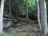
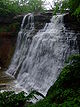
Waterfalls, rolling hills, caves, winding river scenery attract many park visitors. Steep narrow ravines, a rolling floodplain, and lush farmland contrast one another throughout the park. Animal life is also plentiful. The Ledges provides a boulder-strewn cliff to relax and watch the sunset over the wooded scenery below. Sled-riding is popular during the winter at Happy Days Park.
The park offers an array of preserved and restored displays of 19th and early 20th century sustainable farming and pastoral or rural living, while catering to contemporary interests with art exhibits, outdoor concerts, and scenic excursion and special event railroad tours on the Cuyahoga Valley Scenic Railroad
.
It includes compatible-use sites not owned by the federal government, including several local regional parks in the Cleveland Metroparks
and Metro Parks, Serving Summit County
systems, Blossom Music Center
, and the Hale Farm & Village
. In the mid 1980s, the park hosted the National Folk Festival
.
and is the major trail through Cuyahoga Valley National Park. From it visitors can make connections to many of the natural and historic sites in the park and to other trails that intersect it along the way. or through one of the Cuyahoga Valley National Park visitor centers.
 The Towpath Trail follows the historic route of the Ohio & Erie Canal. Before the canal was built, Ohio
was a sparsely settled wilderness where travel was difficult and getting crops to market was nearly impossible. The canal, built between 1825 and 1832, provided a successful transportation route from Cleveland
, on Lake Erie
, to Portsmouth
, on the Ohio River
. The canal opened up Ohio to the rest of the settled eastern United States.
There are numerous wayside exhibits that provide information about canal features and sites of historic interest. There is also a virtual tour.
Today visitors can walk or ride along the same path that the mules used to tow the canal boats loaded with goods and passengers. The scene is different than it was then; the canal was full of water carrying a steady flow of boats amongst the constant conversations of "canawlers." Evidence of beavers can be seen in many places along the trail.

Cuyahoga River
The Cuyahoga River is located in Northeast Ohio in the United States. Outside of Ohio, the river is most famous for being "the river that caught fire", helping to spur the environmental movement in the late 1960s...
between Akron
Akron, Ohio
Akron , is the fifth largest city in the U.S. state of Ohio and the county seat of Summit County. It is located in the Great Lakes region approximately south of Lake Erie along the Little Cuyahoga River. As of the 2010 census, the city had a population of 199,110. The Akron Metropolitan...
and Cleveland
Cleveland, Ohio
Cleveland is a city in the U.S. state of Ohio and is the county seat of Cuyahoga County, the most populous county in the state. The city is located in northeastern Ohio on the southern shore of Lake Erie, approximately west of the Pennsylvania border...
in Northeast Ohio. The 51 square miles (132.1 km²) park is the only national park
National park
A national park is a reserve of natural, semi-natural, or developed land that a sovereign state declares or owns. Although individual nations designate their own national parks differently A national park is a reserve of natural, semi-natural, or developed land that a sovereign state declares or...
in Ohio
Ohio
Ohio is a Midwestern state in the United States. The 34th largest state by area in the U.S.,it is the 7th‑most populous with over 11.5 million residents, containing several major American cities and seven metropolitan areas with populations of 500,000 or more.The state's capital is Columbus...
.
Cuyahoga means "crooked river" in Mohawk
Mohawk language
Mohawk is an Iroquoian language spoken by around 2,000 people of the Mohawk nation in the United States and Canada . Mohawk has the largest number of speakers of the Northern Iroquoian languages; today it is the only one with greater than a thousand remaining...
.
Administrative history
The valley began providing recreation for urban dwellers in the 1870s when people came from nearby cities for carriage rides or leisure boat trips along the canal. In 1880, the Valley RailroadValley Railroad
The following railroads have been called Valley Railroad:*Valley Railroad , a tourist line*Valley Railroad , 1869-1945, predecessor of the Delaware, Lackawanna and Western Railroad*Valley Railroad , Westline to Kushequa...
became another way to escape urban industrial life. Actual park development began in the 1910s and 1920s with the establishment of Cleveland and Akron metropolitan park districts. In 1929 the estate of Cleveland businessman Hayward Kendall donated 430 acres (1.7 km²) around the Richie Ledges and a trust fund to the state of Ohio. Kendall's will stipulated that the "property should be perpetually used for park purposes". It became Virginia Kendall park, in honor of his mother. In the 1930s, the Civilian Conservation Corps
Civilian Conservation Corps
The Civilian Conservation Corps was a public work relief program that operated from 1933 to 1942 in the United States for unemployed, unmarried men from relief families, ages 18–25. A part of the New Deal of President Franklin D...
built much of the park's infrastructure including what are now Happy Days Lodge and the shelters at Octagon, Ledges, and Kendall Lake.
Although regional parks safeguarded certain places, by the 1960s local citizens feared that urban sprawl would overwhelm the Cuyahoga Valley's natural beauty. Active citizens joined forces with state and national government staff to find a long term solution. Finally, on December 27, 1974, President Gerald Ford signed the bill establishing the Cuyahoga Valley National Recreation Area. The area was redesignated a national park by Congress on October 11, 2000, with the passage of the Department of the Interior and Related Agencies Appropriations Act, 2001, House Bill 4578, 106th congress. It is administered by the National Park Service
National Park Service
The National Park Service is the U.S. federal agency that manages all national parks, many national monuments, and other conservation and historical properties with various title designations...
. David Berger National Memorial
David Berger National Memorial
David Berger National Memorial honors the memory of David Mark Berger, a U.S. citizen who competed for Israel and was one of the 11 Israeli athletes killed in the Munich massacre at the 1972 Summer Olympics. Berger was a 28-year-old weightlifter...
in Beachwood, Ohio
Beachwood, Ohio
-External links:* *...
is also managed through Cuyahoga Valley National Park.
The Richfield Coliseum, a multipurpose arena in the Cuyahoga River area, was demolished in 1999 and the now-empty site became part of Cuyahoga Valley National Park upon its designation in 2000. It has since become a grassy meadow popular with birdwatchers.
Attractions
Many visitors spend their time hikingHiking
Hiking is an outdoor activity which consists of walking in natural environments, often in mountainous or other scenic terrain. People often hike on hiking trails. It is such a popular activity that there are numerous hiking organizations worldwide. The health benefits of different types of hiking...
or bicycling the parks' many trails which visit its numerous attractions, including the crushed limestone along portions of the 20 miles (32.2 km) Towpath Trail, following a former stretch of the 308 miles (495.7 km) Ohio and Erie Canal
Ohio and Erie Canal
The Ohio Canal or Ohio and Erie Canal was a canal constructed in the 1820s and early 1830s. It connected Akron, Summit County, with the Cuyahoga River near its mouth on Lake Erie in Cleveland, Cuyahoga County, and a few years later, with the Ohio River near Portsmouth, Scioto County, and then...
.
Waterfalls, rolling hills, caves, winding river scenery attract many park visitors. Steep narrow ravines, a rolling floodplain, and lush farmland contrast one another throughout the park. Animal life is also plentiful. The Ledges provides a boulder-strewn cliff to relax and watch the sunset over the wooded scenery below. Sled-riding is popular during the winter at Happy Days Park.
The park offers an array of preserved and restored displays of 19th and early 20th century sustainable farming and pastoral or rural living, while catering to contemporary interests with art exhibits, outdoor concerts, and scenic excursion and special event railroad tours on the Cuyahoga Valley Scenic Railroad
Cuyahoga Valley Scenic Railroad
Cuyahoga Valley Scenic Railroad is a Class III railroad and steam-powered excursion trips through Peninsula, Ohio in the Cuyahoga Valley, primarily through the scenic Cuyahoga Valley National Park.-History:...
.
It includes compatible-use sites not owned by the federal government, including several local regional parks in the Cleveland Metroparks
Cleveland Metroparks
Cleveland Metroparks is an extensive system of nature preserves in Greater Cleveland, Ohio. The various reservations, which largely encircle the city of Cleveland, tend to follow the rivers and creeks that flow through the region...
and Metro Parks, Serving Summit County
Metro Parks, Serving Summit County
' is a Metroparks system serving the citizens of Summit County, Ohio by managing in 14 developed parks, six conservation areas and more than of trails.The park district is fully supported by a levy, which voters are periodically asked to approve...
systems, Blossom Music Center
Blossom Music Center
Blossom Music Center is an amphitheatre located in Cuyahoga Falls, Ohio. The pavilion seats 5,700 people, with space for about 13,500 more on the lawn. It is the summer home of the Cleveland Orchestra, which performs its annual Blossom Festival there. The venue is also host to a full summer...
, and the Hale Farm & Village
Hale Farm & Village
Hale Farm and Village is a historic property of the Western Reserve Historical Society in Bath Township, Summit County, Ohio, United States. It is within the boundaries of the Cuyahoga Valley National Park. Hale Farm was the original homestead of Jonathan Hale a Connecticut farmer who migrated to...
. In the mid 1980s, the park hosted the National Folk Festival
National Folk Festival (USA)
The National Folk Festival is an itinerant folk festival in the United States. Since 1934, it has been run by the National Council for the Traditional Arts and has been presented in 26 communities around the nation...
.
Ohio and Erie Canal Towpath Trail
The multi-purpose Ohio & Erie Canal Towpath trail was developed by the National Park ServiceNational Park Service
The National Park Service is the U.S. federal agency that manages all national parks, many national monuments, and other conservation and historical properties with various title designations...
and is the major trail through Cuyahoga Valley National Park. From it visitors can make connections to many of the natural and historic sites in the park and to other trails that intersect it along the way. or through one of the Cuyahoga Valley National Park visitor centers.
History
Ohio
Ohio is a Midwestern state in the United States. The 34th largest state by area in the U.S.,it is the 7th‑most populous with over 11.5 million residents, containing several major American cities and seven metropolitan areas with populations of 500,000 or more.The state's capital is Columbus...
was a sparsely settled wilderness where travel was difficult and getting crops to market was nearly impossible. The canal, built between 1825 and 1832, provided a successful transportation route from Cleveland
Cleveland, Ohio
Cleveland is a city in the U.S. state of Ohio and is the county seat of Cuyahoga County, the most populous county in the state. The city is located in northeastern Ohio on the southern shore of Lake Erie, approximately west of the Pennsylvania border...
, on Lake Erie
Lake Erie
Lake Erie is the fourth largest lake of the five Great Lakes in North America, and the tenth largest globally. It is the southernmost, shallowest, and smallest by volume of the Great Lakes and therefore also has the shortest average water residence time. It is bounded on the north by the...
, to Portsmouth
Portsmouth, Ohio
Portsmouth is a city in the U.S. state of Ohio and the county seat of Scioto County. The municipality is located on the northern banks of the Ohio River and east of the Scioto River in Southern Ohio. The population was 20,226 at the 2010 census.-Foundation:...
, on the Ohio River
Ohio River
The Ohio River is the largest tributary, by volume, of the Mississippi River. At the confluence, the Ohio is even bigger than the Mississippi and, thus, is hydrologically the main stream of the whole river system, including the Allegheny River further upstream...
. The canal opened up Ohio to the rest of the settled eastern United States.
There are numerous wayside exhibits that provide information about canal features and sites of historic interest. There is also a virtual tour.
Today visitors can walk or ride along the same path that the mules used to tow the canal boats loaded with goods and passengers. The scene is different than it was then; the canal was full of water carrying a steady flow of boats amongst the constant conversations of "canawlers." Evidence of beavers can be seen in many places along the trail.
Stanford House (Formerly Stanford Hostel)
Located in the scenic Cuyahoga Valley near Peninsula, Ohio, Stanford House is a historic nineteenth-century farm home built in the 1830s by George Stanford, one of the first settlers in the Western Reserve. In 1978, the NPS purchased the property to act as a youth hostel in conjunction with the American Youth Hostels (AYH) organization. In March 2011, Stanford Hostel became Stanford House, Cuyahoga Valley National Park's first in-park lodging facility. The home was renovated by the Conservancy for Cuyahoga Valley National Park and the National Park Service.Towpath trailheads
| Coordinates Geographic coordinate system A geographic coordinate system is a coordinate system that enables every location on the Earth to be specified by a set of numbers. The coordinates are often chosen such that one of the numbers represent vertical position, and two or three of the numbers represent horizontal position... | Trailhead Map | Address | Description |
|---|---|---|---|
| Lock 39 | |||
| 41.373272°N 81.616382°W | Canal Visitor Center | Canal Road & Hillside Road, Valley View, Ohio Valley View, Ohio Valley View is a village in Cuyahoga County, Ohio, United States. The population was 2,034 at the 2010 census. It is a suburb of Cleveland with a town council form of government. It is part of a school district that also includes nearby Cuyahoga Heights and Brooklyn Heights... 44125, 1½ miles south of Rockside Road |
|
| Frazee House | Canal Road, Valley View, Ohio Valley View, Ohio Valley View is a village in Cuyahoga County, Ohio, United States. The population was 2,034 at the 2010 census. It is a suburb of Cleveland with a town council form of government. It is part of a school district that also includes nearby Cuyahoga Heights and Brooklyn Heights... , 3½ miles south of Rockside Road |
||
| 41°19′10"N 081°35′15"W | Station Road Bridge | ||
| Red Lock | |||
| Boston Store | Boston Mills Road, 1/10 of a mile east of Riverview Road |
||
| Lock 29 | |||
| Hunt Farm Visitor Information Center | Bolanz Road, between Akron-Peninsula Road and Riverview Road |
||
| Ira | |||
| Indian Mound | |||
Visitor centers
| Coordinates Geographic coordinate system A geographic coordinate system is a coordinate system that enables every location on the Earth to be specified by a set of numbers. The coordinates are often chosen such that one of the numbers represent vertical position, and two or three of the numbers represent horizontal position... |
Visitor Center |
Address |
Description |
|---|---|---|---|
| 41.373272°N 81.616382°W | Canal | Canal Road & Hillside Road, Valley View, Ohio Valley View, Ohio Valley View is a village in Cuyahoga County, Ohio, United States. The population was 2,034 at the 2010 census. It is a suburb of Cleveland with a town council form of government. It is part of a school district that also includes nearby Cuyahoga Heights and Brooklyn Heights... 44125, 1½ miles south of Rockside Road |
Canal Visitor Center contains exhibits and a bookstore. Exhibits illustrate 12,000 years of history in the valley, including the history of the canal. The canal-era building once served canal boat passengers waiting to pass through Ohio & Erie Canal Lock 38. Canal lock demonstrations are conducted seasonally on weekends by National Park Service staff and by volunteers wearing period costumes. A 20-minute slide program about the park and three, 30-minute videos on canal history are shown on request. |
| Happy Days | State Route 303, 1 mile west of State Route 8, 2 miles east of the Village of Peninsula, Ohio Peninsula, Ohio Peninsula is a village in Summit County, Ohio, United States. The population was 602 at the 2000 census. It is part of the Akron Metropolitan Statistical Area.... |
Happy Days was constructed by the Civilian Conservation Corps Civilian Conservation Corps The Civilian Conservation Corps was a public work relief program that operated from 1933 to 1942 in the United States for unemployed, unmarried men from relief families, ages 18–25. A part of the New Deal of President Franklin D... in 1938 and 1939 as a camp for urban children. The visitor center offers information and a variety of activities, including concerts, lectures, plays, and special events. A 20-minute slide program about the park is shown on request. Several hiking trails are located nearby. |
|
| Boston Store | Boston Mills Road, 1/10 of a mile east of Riverview Road |
Boston Store was constructed in 1836 and has been used as a warehouse, store, post office, and gathering place. It is now a museum featuring exhibits relating to canal boat-building. | |
| Hunt Farm | Bolanz Road, between Akron-Peninsula Road and Riverview Road |
The Hunt Farm property is typical of the small family farms that dotted the Cuyahoga Valley in the late 19th century. Here you can get information about park activities and see exhibits about the area's agricultural history. Next to the Ohio & Erie Canal Towpath Trail, it is an ideal starting point for a hike or a bicycle ride. | |
| Frazee House | Canal Road, Valley View, Ohio Valley View, Ohio Valley View is a village in Cuyahoga County, Ohio, United States. The population was 2,034 at the 2010 census. It is a suburb of Cleveland with a town council form of government. It is part of a school district that also includes nearby Cuyahoga Heights and Brooklyn Heights... , 3½ miles south of Rockside Road |
The Frazee House was constructed in 1825 and 1826, during the same years the northern section of the Ohio & Erie Canal was dug. It is a fine example of a Western Reserve home and features exhibits relating to architectural styles, construction techniques, and the Frazee family. | |
| 41.242287°N 81.549124°W | Peninsula Depot Cuyahoga Valley Scenic Railroad Cuyahoga Valley Scenic Railroad is a Class III railroad and steam-powered excursion trips through Peninsula, Ohio in the Cuyahoga Valley, primarily through the scenic Cuyahoga Valley National Park.-History:... |
1630 West Mill Street, Village of Peninsula, Ohio Peninsula, Ohio Peninsula is a village in Summit County, Ohio, United States. The population was 602 at the 2000 census. It is part of the Akron Metropolitan Statistical Area.... 44264, north of State Route 303 |
The Peninsula Depot Cuyahoga Valley Scenic Railroad Cuyahoga Valley Scenic Railroad is a Class III railroad and steam-powered excursion trips through Peninsula, Ohio in the Cuyahoga Valley, primarily through the scenic Cuyahoga Valley National Park.-History:... was originally located in the village of Boston, just north of Boston Mills Road. It was moved to Peninsula in the late 1960s. The building may be the only surviving combination station from the Valley Railway, which operated between Cleveland, Ohio Cleveland, Ohio Cleveland is a city in the U.S. state of Ohio and is the county seat of Cuyahoga County, the most populous county in the state. The city is located in northeastern Ohio on the southern shore of Lake Erie, approximately west of the Pennsylvania border... and Tuscarawas County, Ohio Tuscarawas County, Ohio Tuscarawas County is a county located in the eastern part of the state of Ohio. As of the 2010 census, the population was 92,582. Its county seat is New Philadelphia... in the late 19th century. Today the Peninsula Depot serves as an information and orientation center for people on foot, bike, and rail, and serves as a station for Cuyahoga Valley Scenic Railroad Cuyahoga Valley Scenic Railroad Cuyahoga Valley Scenic Railroad is a Class III railroad and steam-powered excursion trips through Peninsula, Ohio in the Cuyahoga Valley, primarily through the scenic Cuyahoga Valley National Park.-History:... (CVSR) excursions. Exhibits highlight the history and recreational opportunities of the area. |
Points of historic interest
| Coordinates Geographic coordinate system A geographic coordinate system is a coordinate system that enables every location on the Earth to be specified by a set of numbers. The coordinates are often chosen such that one of the numbers represent vertical position, and two or three of the numbers represent horizontal position... |
Location |
Description |
|||
|---|---|---|---|---|---|
| 41°22′24"N 81°36′59"W | Canal Visitor Center - "Hell's Half Acre" | Exhibits related to human history in the valley and Ohio & Erie Canal history are available at Canal Visitor Center. The exhibits are housed in a renovated canal-era tavern that, for some time, had such a colorful reputation that it came to be called "Hell's Half Acre." Lock 38 is located in the front; lock demonstrations are offered by volunteers and staff in period costume every Saturday, Sunday, and holiday during the summer months. A lock model is located inside the visitor center. The ranger at the information desk will perform lock model demonstrations on request. An auditorium in the basement is used to show three different canal-related videos and one park orientation slide program. These programs will be run on request. | |||
| Ohio & Erie Canal Related Structures | The Ohio & Erie Canal was constructed between 1825 and 1832. It successfully provided Ohio Ohio Ohio is a Midwestern state in the United States. The 34th largest state by area in the U.S.,it is the 7th‑most populous with over 11.5 million residents, containing several major American cities and seven metropolitan areas with populations of 500,000 or more.The state's capital is Columbus... with a transportation system that permitted residents to conduct trade with the world. While it stopped functioning after the great flood of 1913, remnants and ruins of canal-related structures can be seen alongside the Ohio & Erie Canal Towpath Trail. Wayside exhibits explain the function of many of the structures visible from the trail. Our Towpath Trail Sites to Visit list may be useful in directing you to the points of greatest interest. |
||||
| Frazee House | The Frazee House was under construction in 1825 when the canal was dug through its front yard. It's a great place to visit for information about Western Reserve architecture and construction techniques as well as some tidbits about the Frazee family. | ||||
| Boston Store | This early canal-era building was owned by the Boston Land & Manufacturing Company. The Boston Store now houses numerous exhibits relating to canal boat building. |  |
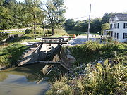
Everett Road Covered Bridge | The Everett Road Covered Bridge was constructed after a local resident was killed attempting to cross the swollen Furnace Run in 1877. It was destroyed by storm floodwaters in 1975 and reconstructed by the National Park Service National Park Service The National Park Service is the U.S. federal agency that manages all national parks, many national monuments, and other conservation and historical properties with various title designations... in 1986. It is the only covered bridge in Summit County Summit County, Ohio Summit County is an urban county located in the state of Ohio, United States. As of the 2000 census, the population was 542,899. In the 2010 Census the population was 541,781. Its county seat is Akron... today. The bridge is located on Everett Road about 5/10 of a mile west of Riverview Road near Everett Village. |
|
 |
Brandywine Village Brandywine Village, Ohio Brandywine Village, Ohio is a former settlement located near Brandywine Falls in Summit County, Ohio, USA. It is within the boundaries of the Cuyahoga Valley National Park... |
Brandywine Village Brandywine Village, Ohio Brandywine Village, Ohio is a former settlement located near Brandywine Falls in Summit County, Ohio, USA. It is within the boundaries of the Cuyahoga Valley National Park... was conceived and founded by George Wallace, who built a sawmill next to Brandywine Falls in 1814. He encouraged others to move to the area, including his brother-in-law, who built a grist mill on the opposite side of the falls. With inexpensive land available and the presence of mills to provide lumber, flour, and corn meal, the Village of Brandywine Brandywine Village, Ohio Brandywine Village, Ohio is a former settlement located near Brandywine Falls in Summit County, Ohio, USA. It is within the boundaries of the Cuyahoga Valley National Park... began to grow. Today only a couple of buildings remain from the village but historic photos and remnants of building foundations allow us to remember the Brandywine Village Brandywine Village, Ohio Brandywine Village, Ohio is a former settlement located near Brandywine Falls in Summit County, Ohio, USA. It is within the boundaries of the Cuyahoga Valley National Park... that once was. |
|||
| Civilian Conservation Corps Civilian Conservation Corps The Civilian Conservation Corps was a public work relief program that operated from 1933 to 1942 in the United States for unemployed, unmarried men from relief families, ages 18–25. A part of the New Deal of President Franklin D... Structures |
The Civilian Conservation Corps Civilian Conservation Corps The Civilian Conservation Corps was a public work relief program that operated from 1933 to 1942 in the United States for unemployed, unmarried men from relief families, ages 18–25. A part of the New Deal of President Franklin D... was responsible for the construction of some of the most attractive buildings in the valley. Happy Days Visitor Center as well as the Ledges, Octagon, and Lake Shelters were built of wormy American Chestnut wood in the late 1930s. These structures can be found in the Virginia Kendall Unit of the park. |
||||
| The George Stanford House | James Stanford moved to Boston Township immediately after surveying and naming it in 1806. He and with his wife Polly and son George were the first homesteaders in what is today Cuyahoga Valley National Park (CVNP). His son George built a stately Greek revival home in about 1830. That home, located at 6093 Stanford Road, now serves as the Cuyahoga Valley HI-Stanford Hostel. | ||||
| National Register of Historic Places National Register of Historic Places The National Register of Historic Places is the United States government's official list of districts, sites, buildings, structures, and objects deemed worthy of preservation... |
This page contains a complete list of National Register of Historic Places National Register of Historic Places The National Register of Historic Places is the United States government's official list of districts, sites, buildings, structures, and objects deemed worthy of preservation... locations within CVNP. Some of these locations are privately owned. |
||||
| Hale Farm & Village Hale Farm & Village Hale Farm and Village is a historic property of the Western Reserve Historical Society in Bath Township, Summit County, Ohio, United States. It is within the boundaries of the Cuyahoga Valley National Park. Hale Farm was the original homestead of Jonathan Hale a Connecticut farmer who migrated to... |
Hale Farm & Village Hale Farm & Village Hale Farm and Village is a historic property of the Western Reserve Historical Society in Bath Township, Summit County, Ohio, United States. It is within the boundaries of the Cuyahoga Valley National Park. Hale Farm was the original homestead of Jonathan Hale a Connecticut farmer who migrated to... is an outdoor living history museum that is just a few miles and 150 years away. Costumed "pioneer" interpreters describe life in the Western Reserve during the formative years of the United States of America. The village features 21 historic buildings to tour and many talented craftspeople. It is operated by the Western Reserve Historical Society Western Reserve Historical Society The Western Reserve Historical Society was founded in 1867, making it the oldest cultural institution in Northeast Ohio. WRHS is located in Cleveland, Ohio, USA.-About:... . Craft demonstrations include glassblowing, candlemaking, broommaking, spinning & weaving, cheesemaking, blacksmithing, woodworking, sawmilling, hearth cooking, and pottery making. The farm also features oxen, sheep, cows, and gardens. |
||||
National Register of Historic Places
Many of the listed homes are in private ownership.| # | Coordinates Geographic coordinate system A geographic coordinate system is a coordinate system that enables every location on the Earth to be specified by a set of numbers. The coordinates are often chosen such that one of the numbers represent vertical position, and two or three of the numbers represent horizontal position... |
Locale |
Historic |
Status |
Address |
Register Date |
|---|---|---|---|---|---|---|
| Cuyahoga County Cuyahoga County, Ohio Cuyahoga County is a county located in the state of Ohio, United States. It is the most populous county in Ohio; as of the 2010 census, the population was 1,280,122. Its county seat is Cleveland. Cuyahoga County is part of Greater Cleveland, a metropolitan area, and Northeast Ohio, a... and Summit County Summit County, Ohio Summit County is an urban county located in the state of Ohio, United States. As of the 2000 census, the population was 542,899. In the 2010 Census the population was 541,781. Its county seat is Akron... |
||||||
| 1. | Agricultural Resources of Cuyahoga Valley | Multiple Property Document Form | NO PUBLIC FACILITIES | 3/12/93 | ||
| 2. | Independence Independence, Ohio Independence is a city in Cuyahoga County, Ohio, in the United States. As of the 2010 census, the city population was 7,133.-Geography:Independence is located at .According to the United States Census Bureau, the city has a total area of , all of it land.... to Akron Akron, Ohio Akron , is the fifth largest city in the U.S. state of Ohio and the county seat of Summit County. It is located in the Great Lakes region approximately south of Lake Erie along the Little Cuyahoga River. As of the 2010 census, the city had a population of 199,110. The Akron Metropolitan... |
Valley Railway Historic District | Cuyahoga Valley between Rockside Rd. at CVNP and Howard St. at Little Cuyahoga Valley. | 5/17/85 | ||
| 3. | Recreation/Conservation Resources of Cuyahoga Valley | Multiple Property Document Form | 1/10/97 | |||
| Cuyahoga County Cuyahoga County, Ohio Cuyahoga County is a county located in the state of Ohio, United States. It is the most populous county in Ohio; as of the 2010 census, the population was 1,280,122. Its county seat is Cleveland. Cuyahoga County is part of Greater Cleveland, a metropolitan area, and Northeast Ohio, a... |
||||||
| 4. | Bedford Bedford, Ohio Bedford is a city in Cuyahoga County, Ohio, United States. The population was 13,074 at the 2010 census. It is an eastern suburb of Cleveland.-Geography:Bedford is located at .... |
Cleveland and Pittsburgh Railroad Bridge | OPEN TO THE PUBLIC | Tinkers Creek | 7/24/75 | |
| 5. | 41°19′17"N 081°35′14"W | Brecksville Brecksville, Ohio -External links:* * *... |
Brecksville-Northfield High Level Bridge - STATE HIGHWAY BRIDGE | OPEN TO THE PUBLIC | Ohio State Route 82 and Cuyahoga River Cuyahoga River The Cuyahoga River is located in Northeast Ohio in the United States. Outside of Ohio, the river is most famous for being "the river that caught fire", helping to spur the environmental movement in the late 1960s... (also in Northfield Northfield, Ohio Northfield is a village in Summit County, Ohio, United States. The population was 3,827 at the 2000 census. It is part of the Akron Metropolitan Statistical Area.-Geography:Northfield is located at .... , Summit County, Ohio Summit County, Ohio Summit County is an urban county located in the state of Ohio, United States. As of the 2000 census, the population was 542,899. In the 2010 Census the population was 541,781. Its county seat is Akron... ) Best viewed from Station Road Bridge Trailhead on the Towpath Trail (Riverview Rd. just South of Ohio State Route 82) |
1/6/86 |
| 6. | Brecksville Brecksville, Ohio -External links:* * *... |
Burt,William House | NO PUBLIC FACILITIES | 9525 Brecksville Road | 3/7/79 | |
| 7. | Brecksville Brecksville, Ohio -External links:* * *... |
Rich, Charles B., House | NO PUBLIC FACILITIES | 9367 Brecksville Rd. | 2/22/79 | |
| 8. | Brecksville Brecksville, Ohio -External links:* * *... |
Brecksville Trailside Museum - (CLEVELAND METROPARKS Cleveland Metroparks Cleveland Metroparks is an extensive system of nature preserves in Greater Cleveland, Ohio. The various reservations, which largely encircle the city of Cleveland, tend to follow the rivers and creeks that flow through the region... NATURE CENTER) |
Chippewa Creek Drive off Ohio State Route 82 | 9?/92 | ||
| 9. | Brecksville Brecksville, Ohio -External links:* * *... vicinity |
Coonrad, Jonas, House | NO PUBLIC FACILITIES | 10340 Riverview Road | 7/24/79 | |
| 10. | Brecksville Brecksville, Ohio -External links:* * *... vicinity |
Vaughn Site (33CU65) Address Restricted | NO PUBLIC FACILITIES | 11/12/87 | ||
| 11. | Brecksville Brecksville, Ohio -External links:* * *... vicinity |
Vaughn, Richard Farm | NO PUBLIC FACILITIES | 9570 Riverview Road | 3/12/93 | |
| 12. | Independence Independence, Ohio Independence is a city in Cuyahoga County, Ohio, in the United States. As of the 2010 census, the city population was 7,133.-Geography:Independence is located at .According to the United States Census Bureau, the city has a total area of , all of it land.... |
Packard-Doubler House | NO PUBLIC FACILITIES - PRIVATE PROPERTY | 7634 Riverview Road | 3/9/79 | |
| 13. | Independence Independence, Ohio Independence is a city in Cuyahoga County, Ohio, in the United States. As of the 2010 census, the city population was 7,133.-Geography:Independence is located at .According to the United States Census Bureau, the city has a total area of , all of it land.... vicinity |
South Park Site | NO PUBLIC FACILITIES | Address Restricted | 6/22/76 | |
| 14. | Independence Independence, Ohio Independence is a city in Cuyahoga County, Ohio, in the United States. As of the 2010 census, the city population was 7,133.-Geography:Independence is located at .According to the United States Census Bureau, the city has a total area of , all of it land.... vicinity |
Terra Vista Archeological District | NO PUBLIC FACILITIES | Address Restricted | 5/23/78 | |
| 15. | Independence Independence, Ohio Independence is a city in Cuyahoga County, Ohio, in the United States. As of the 2010 census, the city population was 7,133.-Geography:Independence is located at .According to the United States Census Bureau, the city has a total area of , all of it land.... to Akron Akron, Ohio Akron , is the fifth largest city in the U.S. state of Ohio and the county seat of Summit County. It is located in the Great Lakes region approximately south of Lake Erie along the Little Cuyahoga River. As of the 2010 census, the city had a population of 199,110. The Akron Metropolitan... Valley Railway Historic District |
Cuyahoga Valley Scenic Railroad Cuyahoga Valley Scenic Railroad Cuyahoga Valley Scenic Railroad is a Class III railroad and steam-powered excursion trips through Peninsula, Ohio in the Cuyahoga Valley, primarily through the scenic Cuyahoga Valley National Park.-History:... |
OPEN TO THE PUBLIC FOR SCENIC TRAIN RIDES | Cuyahoga Valley National Recreation Area Between Rockside Rd. and Howard St. at Little Cuyahoga Valley | 5/17/85 | |
| 16. | Valley View Valley View, Ohio Valley View is a village in Cuyahoga County, Ohio, United States. The population was 2,034 at the 2010 census. It is a suburb of Cleveland with a town council form of government. It is part of a school district that also includes nearby Cuyahoga Heights and Brooklyn Heights... |
Frazee, Stephen House | CVNP VISITOR CENTER WITH LIMITED OPEN HOURS | 7733 Canal Road | 5/4/76 | |
| 17. | Valley View Valley View, Ohio Valley View is a village in Cuyahoga County, Ohio, United States. The population was 2,034 at the 2010 census. It is a suburb of Cleveland with a town council form of government. It is part of a school district that also includes nearby Cuyahoga Heights and Brooklyn Heights... |
Gleason, Edmund House | NO PUBLIC FACILITIES | 7243 Canal Rd. | 12/18/79 | |
| 18. | Valley View Valley View, Ohio Valley View is a village in Cuyahoga County, Ohio, United States. The population was 2,034 at the 2010 census. It is a suburb of Cleveland with a town council form of government. It is part of a school district that also includes nearby Cuyahoga Heights and Brooklyn Heights... |
Gleason Farm - Boundary Increase | NO PUBLIC FACILITIES | 7243 Canal Rd., | 3/12/93 | |
| 19. | Valley View Valley View, Ohio Valley View is a village in Cuyahoga County, Ohio, United States. The population was 2,034 at the 2010 census. It is a suburb of Cleveland with a town council form of government. It is part of a school district that also includes nearby Cuyahoga Heights and Brooklyn Heights... |
Knapp, William, House | NO PUBLIC FACILITIES | 7101 Canal Road | 3/19/79 | |
| 20. | Valley View Valley View, Ohio Valley View is a village in Cuyahoga County, Ohio, United States. The population was 2,034 at the 2010 census. It is a suburb of Cleveland with a town council form of government. It is part of a school district that also includes nearby Cuyahoga Heights and Brooklyn Heights... |
Lock No. 37 and Spillway Ohio and Erie Canal Ohio and Erie Canal The Ohio Canal or Ohio and Erie Canal was a canal constructed in the 1820s and early 1830s. It connected Akron, Summit County, with the Cuyahoga River near its mouth on Lake Erie in Cleveland, Cuyahoga County, and a few years later, with the Ohio River near Portsmouth, Scioto County, and then... Towpath Trail |
OPEN TO THE PUBLIC | Fitzwater Road | 12/11/79 | |
| 21. | Valley View Valley View, Ohio Valley View is a village in Cuyahoga County, Ohio, United States. The population was 2,034 at the 2010 census. It is a suburb of Cleveland with a town council form of government. It is part of a school district that also includes nearby Cuyahoga Heights and Brooklyn Heights... |
Lock No. 38 and Spillway Ohio and Erie Canal Ohio and Erie Canal The Ohio Canal or Ohio and Erie Canal was a canal constructed in the 1820s and early 1830s. It connected Akron, Summit County, with the Cuyahoga River near its mouth on Lake Erie in Cleveland, Cuyahoga County, and a few years later, with the Ohio River near Portsmouth, Scioto County, and then... Towpath Trail |
OPEN TO THE PUBLIC | Hillside Road | 12/11/79 | |
| 22. | Valley View Valley View, Ohio Valley View is a village in Cuyahoga County, Ohio, United States. The population was 2,034 at the 2010 census. It is a suburb of Cleveland with a town council form of government. It is part of a school district that also includes nearby Cuyahoga Heights and Brooklyn Heights... |
Lock No. 39 and Spillway Ohio and Erie Canal Ohio and Erie Canal The Ohio Canal or Ohio and Erie Canal was a canal constructed in the 1820s and early 1830s. It connected Akron, Summit County, with the Cuyahoga River near its mouth on Lake Erie in Cleveland, Cuyahoga County, and a few years later, with the Ohio River near Portsmouth, Scioto County, and then... Towpath Trail |
OPEN TO THE PUBLIC | Canal Road | 12/11/79 | |
| 23. | 41°22′24"N 81°36′59"W | Valley View Valley View, Ohio Valley View is a village in Cuyahoga County, Ohio, United States. The population was 2,034 at the 2010 census. It is a suburb of Cleveland with a town council form of government. It is part of a school district that also includes nearby Cuyahoga Heights and Brooklyn Heights... |
Inn at Lock 38 a.k.a. Canal Visitor Center - CVNP VISITOR CENTER | OPEN TO THE PUBLIC | a.k.a. Hell's Half Acre Hell's Half Acre Hell’s Half-Acre, Hell’s Half-acre, or Hell’s Half Acre can refer to:In places:*Hell's Half Acre Lava Field, a basaltic lava field on the Snake River Plain, Idaho, USA... Ohio and Erie Canal Ohio and Erie Canal The Ohio Canal or Ohio and Erie Canal was a canal constructed in the 1820s and early 1830s. It connected Akron, Summit County, with the Cuyahoga River near its mouth on Lake Erie in Cleveland, Cuyahoga County, and a few years later, with the Ohio River near Portsmouth, Scioto County, and then... Towpath Trail, 7104 Canal Road |
12/11/79 |
| 24. | 41°21′53"N 081°36′32"W | Valley View Valley View, Ohio Valley View is a village in Cuyahoga County, Ohio, United States. The population was 2,034 at the 2010 census. It is a suburb of Cleveland with a town council form of government. It is part of a school district that also includes nearby Cuyahoga Heights and Brooklyn Heights... |
Tinkers Creek Aqueduct Tinkers Creek Aqueduct Tinkers Creek Aqueduct is an aqueduct that was constructed to bridge the Ohio and Erie Canal over Tinkers Creek near its confluence with the Cuyahoga River in Valley View, Ohio. It is a relatively rare surviving example of an Ohio and Erie Canal aqueduct. It was originally constructed in... Ohio and Erie Canal Ohio and Erie Canal The Ohio Canal or Ohio and Erie Canal was a canal constructed in the 1820s and early 1830s. It connected Akron, Summit County, with the Cuyahoga River near its mouth on Lake Erie in Cleveland, Cuyahoga County, and a few years later, with the Ohio River near Portsmouth, Scioto County, and then... Towpath Trail |
OPEN TO THE PUBLIC | Tinkers Creek Tinkers Creek Tinker's Creek, in Cuyahoga, Summit and Portage counties, is the largest tributary of the Cuyahoga River, providing about a third of its flow into Lake Erie.-History:... |
12/11/79 |
| 25. | Valley View Valley View, Ohio Valley View is a village in Cuyahoga County, Ohio, United States. The population was 2,034 at the 2010 census. It is a suburb of Cleveland with a town council form of government. It is part of a school district that also includes nearby Cuyahoga Heights and Brooklyn Heights... |
Ulyatt, Abraham, House | NO PUBLIC FACILITIES | 6579 Canal Road | 2/27/79 | |
| 26. | Valley View Valley View, Ohio Valley View is a village in Cuyahoga County, Ohio, United States. The population was 2,034 at the 2010 census. It is a suburb of Cleveland with a town council form of government. It is part of a school district that also includes nearby Cuyahoga Heights and Brooklyn Heights... |
Wilson Feed Mill | OPEN TO PUBLIC AS A FEED AND GRAIN STORE | Ohio and Erie Canal Ohio and Erie Canal The Ohio Canal or Ohio and Erie Canal was a canal constructed in the 1820s and early 1830s. It connected Akron, Summit County, with the Cuyahoga River near its mouth on Lake Erie in Cleveland, Cuyahoga County, and a few years later, with the Ohio River near Portsmouth, Scioto County, and then... Towpath Trail, 7604 Canal Road |
12/17/79 | |
| 27. | Valley View Valley View, Ohio Valley View is a village in Cuyahoga County, Ohio, United States. The population was 2,034 at the 2010 census. It is a suburb of Cleveland with a town council form of government. It is part of a school district that also includes nearby Cuyahoga Heights and Brooklyn Heights... Village |
Ohio and Erie Canal Ohio and Erie Canal The Ohio Canal or Ohio and Erie Canal was a canal constructed in the 1820s and early 1830s. It connected Akron, Summit County, with the Cuyahoga River near its mouth on Lake Erie in Cleveland, Cuyahoga County, and a few years later, with the Ohio River near Portsmouth, Scioto County, and then... |
OPEN TO THE PUBLIC VIA THE TOWPATH TRAIL | Ohio State Route 631 | 11/13/65 NHL 11/13/66 | |
| Summit County Summit County, Ohio Summit County is an urban county located in the state of Ohio, United States. As of the 2000 census, the population was 542,899. In the 2010 Census the population was 541,781. Its county seat is Akron... |
||||||
| 28. | Akron Akron, Ohio Akron , is the fifth largest city in the U.S. state of Ohio and the county seat of Summit County. It is located in the Great Lakes region approximately south of Lake Erie along the Little Cuyahoga River. As of the 2010 census, the city had a population of 199,110. The Akron Metropolitan... Vicinity |
Barker Village Site | NO PUBLIC FACILITIES | Address Restricted | 04/19/78 | |
| 29. | Bath | Hale, Jonathan Jonathan Hale Jonathan Hale was a Canadian-born film and television actor.-Career:Born Jonathan Hatley in Ontario, Canada, Hale was well known as Dagwood Bumstead's boss, Julius Caesar Dithers, in the Blondie film series in the 1940s. He is also notable for playing Inspector Farnack in various The Saint films... Homestead - HALE FARM & VILLAGE |
OPEN TO THE PUBLIC | 2686 Oak Hill Road | 4/23/73 | |
| 30. | Boston | Boston Land and Manufacturing Company Store a.k.a. Boston Store | CVNP VISITOR CENTER WITH LIMITED OPEN HOURS | Ohio and Erie Canal Ohio and Erie Canal The Ohio Canal or Ohio and Erie Canal was a canal constructed in the 1820s and early 1830s. It connected Akron, Summit County, with the Cuyahoga River near its mouth on Lake Erie in Cleveland, Cuyahoga County, and a few years later, with the Ohio River near Portsmouth, Scioto County, and then... Towpath Trail, Boston Mills Rd |
12/11/79 | |
| 31. | Boston | Lock No. 32 Ohio and Erie Canal Ohio and Erie Canal The Ohio Canal or Ohio and Erie Canal was a canal constructed in the 1820s and early 1830s. It connected Akron, Summit County, with the Cuyahoga River near its mouth on Lake Erie in Cleveland, Cuyahoga County, and a few years later, with the Ohio River near Portsmouth, Scioto County, and then... Towpath Trail |
OPEN TO THE PUBLIC | 800 ft (243.8 m). N of Boston Mills Road | 12/11/79 | |
| 32. | Boston | Boston Mills Historic District | MOST BUILDINGS ARE PRIVATE WITH NO PUBLIC FACILITIES | Boston Mills Rd., Stanford Rd. & Main Street | 11/9/92 | |
| 33. | Boston vicinity | Lock No. 33 Ohio and Erie Canal Ohio and Erie Canal The Ohio Canal or Ohio and Erie Canal was a canal constructed in the 1820s and early 1830s. It connected Akron, Summit County, with the Cuyahoga River near its mouth on Lake Erie in Cleveland, Cuyahoga County, and a few years later, with the Ohio River near Portsmouth, Scioto County, and then... Towpath Trail |
OPEN TO THE PUBLIC | 1 mi (1.6 km). S. of Highland Road | 12/11/79 | |
| 34. | Botzum Botzum, Ohio Botzum was a hamlet in Northampton Township, Summit County, Ohio around what is now the intersection of Bath and Riverview Roads in Akron and Cuyahoga Falls.... |
Botzum Farm | NO PUBLIC FACILITIES | 11/01/96 - Determination of Eligibility | ||
| 35. | Cuyahoga Falls Cuyahoga Falls, Ohio As of the census of 2000, there were 49,374 people, 21,655 households, and 13,317 families residing in the city. The population density was 1,932.9 people per square mile . There were 22,727 housing units at an average density of 889.7 per square mile... |
Hunt/Wilke Farm a.k.a. Hunt Farm Visitor Information Center | CVNP VISITOR CENTER WITH LIMITED OPEN HOURS | Agricultural Resources of Cuyahoga Valley MPD, 2049 Bolanz Road | 3/12/93 | |
| 36. | Brecksville Brecksville, Ohio -External links:* * *... vicinity |
Jaite Mill Historic District - CVNP HEADQUARTERS | NO VISITOR FACILITIES | SE of Brecksville Brecksville, Ohio -External links:* * *... at Riverview and Vaughn roads |
5/21/79 | |
| 37. | 41°19′10"N 081°35′15"W | Brecksville Brecksville, Ohio -External links:* * *... vicinity |
Station Road Bridge | OPEN TO THE PUBLIC | East of Brecksville Brecksville, Ohio -External links:* * *... at Cuyahoga River Cuyahoga River The Cuyahoga River is located in Northeast Ohio in the United States. Outside of Ohio, the river is most famous for being "the river that caught fire", helping to spur the environmental movement in the late 1960s... |
3/7/79 |
| 38. | Everett | Lock No. 27 Ohio and Erie Canal Ohio and Erie Canal The Ohio Canal or Ohio and Erie Canal was a canal constructed in the 1820s and early 1830s. It connected Akron, Summit County, with the Cuyahoga River near its mouth on Lake Erie in Cleveland, Cuyahoga County, and a few years later, with the Ohio River near Portsmouth, Scioto County, and then... Towpath Trail |
OPEN TO THE PUBLIC | Approx. 400 ft (121.9 m). E of intersection of Riverview and Everett roads | 3/12/93 | |
| 39. | Everett vicinity | Everett Knoll Complex Prehistoric District | NO PUBLIC FACILITIES | Address Restricted | 5/25/77 | |
| 40. | Everett vicinity | Furnace Run Aqueduct Ohio and Erie Canal Ohio and Erie Canal The Ohio Canal or Ohio and Erie Canal was a canal constructed in the 1820s and early 1830s. It connected Akron, Summit County, with the Cuyahoga River near its mouth on Lake Erie in Cleveland, Cuyahoga County, and a few years later, with the Ohio River near Portsmouth, Scioto County, and then... Towpath Trail |
OPEN TO THE PUBLIC | Furnace Run | 12/11/79 | |
| 41. | Everett | Everett Historic District | VILLAGE IS OPEN TO THE PUBLIC - SOME BUILDINGS ARE PRIVATE RESIDENCES - NPS BUILDINGS HAVE NO VISITOR FACILITIES | Everett and Riverview roads | 1/14/94 | |
| 42. | Ira | Lock No. 26 Ohio and Erie Canal Ohio and Erie Canal The Ohio Canal or Ohio and Erie Canal was a canal constructed in the 1820s and early 1830s. It connected Akron, Summit County, with the Cuyahoga River near its mouth on Lake Erie in Cleveland, Cuyahoga County, and a few years later, with the Ohio River near Portsmouth, Scioto County, and then... Towpath Trail |
OPEN TO THE PUBLIC | 3.3 mi (5.3 km). N of Ira Road | 12/11/79 | |
| 43. | Northfield Northfield, Ohio Northfield is a village in Summit County, Ohio, United States. The population was 3,827 at the 2000 census. It is part of the Akron Metropolitan Statistical Area.-Geography:Northfield is located at .... Center vicinity |
Wallace Farm | OPEN TO PATRONS OF THE BED & BREAKFAST ONLY (Inn at Brandywine Falls) | 8230 Brandywine Rd. | 6/27/85 | |
| 44. | Peninsula Peninsula, Ohio Peninsula is a village in Summit County, Ohio, United States. The population was 602 at the 2000 census. It is part of the Akron Metropolitan Statistical Area.... |
Everett Road Covered Bridge | OPEN TO THE PUBLIC | SW of Peninsula Peninsula, Ohio Peninsula is a village in Summit County, Ohio, United States. The population was 602 at the 2000 census. It is part of the Akron Metropolitan Statistical Area.... on Everett Rd. over Furnace Creek |
5/23/73 Demolished/Destroyed/Rebuilt | |
| 45. | Peninsula Peninsula, Ohio Peninsula is a village in Summit County, Ohio, United States. The population was 602 at the 2000 census. It is part of the Akron Metropolitan Statistical Area.... |
Lock No. 28 Ohio and Erie Canal Ohio and Erie Canal The Ohio Canal or Ohio and Erie Canal was a canal constructed in the 1820s and early 1830s. It connected Akron, Summit County, with the Cuyahoga River near its mouth on Lake Erie in Cleveland, Cuyahoga County, and a few years later, with the Ohio River near Portsmouth, Scioto County, and then... Towpath Trail |
OPEN TO THE PUBLIC | Deep Lock Quarry Metro Park | 12/11/79 | |
| 46. | Peninsula Peninsula, Ohio Peninsula is a village in Summit County, Ohio, United States. The population was 602 at the 2000 census. It is part of the Akron Metropolitan Statistical Area.... |
Lock No. 29 and Aqueduct Ohio and Erie Canal Ohio and Erie Canal The Ohio Canal or Ohio and Erie Canal was a canal constructed in the 1820s and early 1830s. It connected Akron, Summit County, with the Cuyahoga River near its mouth on Lake Erie in Cleveland, Cuyahoga County, and a few years later, with the Ohio River near Portsmouth, Scioto County, and then... Towpath Trail |
OPEN TO THE PUBLIC | off Ohio State Route 303 | 12/11/79 | |
| 47. | Peninsula Peninsula, Ohio Peninsula is a village in Summit County, Ohio, United States. The population was 602 at the 2000 census. It is part of the Akron Metropolitan Statistical Area.... |
Lock No. 30 and Feeder Dam Ohio and Erie Canal Ohio and Erie Canal The Ohio Canal or Ohio and Erie Canal was a canal constructed in the 1820s and early 1830s. It connected Akron, Summit County, with the Cuyahoga River near its mouth on Lake Erie in Cleveland, Cuyahoga County, and a few years later, with the Ohio River near Portsmouth, Scioto County, and then... Towpath Trail |
OPEN TO THE PUBLIC | Off Ohio State Route 303 | 12/11/79 | |
| 48. | Peninsula Peninsula, Ohio Peninsula is a village in Summit County, Ohio, United States. The population was 602 at the 2000 census. It is part of the Akron Metropolitan Statistical Area.... |
Lock No. 31 Ohio and Erie Canal Ohio and Erie Canal The Ohio Canal or Ohio and Erie Canal was a canal constructed in the 1820s and early 1830s. It connected Akron, Summit County, with the Cuyahoga River near its mouth on Lake Erie in Cleveland, Cuyahoga County, and a few years later, with the Ohio River near Portsmouth, Scioto County, and then... Towpath Trail |
OPEN TO THE PUBLIC | 200 ft (61 m). E. of Cuyahoga River Cuyahoga River The Cuyahoga River is located in Northeast Ohio in the United States. Outside of Ohio, the river is most famous for being "the river that caught fire", helping to spur the environmental movement in the late 1960s... and approx. 0.5 mi (0.80467 km). S of Ohio Turnpike |
12/11/79 | |
| 49. | 41°14′32"N 81°32′57"W | Peninsula Peninsula, Ohio Peninsula is a village in Summit County, Ohio, United States. The population was 602 at the 2000 census. It is part of the Akron Metropolitan Statistical Area.... |
Peninsula Village Peninsula, Ohio Peninsula is a village in Summit County, Ohio, United States. The population was 602 at the 2000 census. It is part of the Akron Metropolitan Statistical Area.... Historic District |
MOST BUILDINGS ARE PRIVATE - SOME ARE RETAIL STORES | Both sides of Ohio State Route 303 | 8/23/74 |
| 50. | Peninsula Peninsula, Ohio Peninsula is a village in Summit County, Ohio, United States. The population was 602 at the 2000 census. It is part of the Akron Metropolitan Statistical Area.... |
Fox House | NO PUBLIC FACILITIES - PRIVATE PROPERTY | 1664 West Main Street | Part I Certification (contributes to the significance of the above-named district and is a certified historic structure for purposes of rehabilitation) 2/13/87, MARO | |
| 51. | Peninsula Peninsula, Ohio Peninsula is a village in Summit County, Ohio, United States. The population was 602 at the 2000 census. It is part of the Akron Metropolitan Statistical Area.... |
Tilden, Daniel, House | NO PUBLIC FACILITIES - PRIVATE PROPERTY | 2325 Stine Rd. | 6/20/85 | |
| 52. | Peninsula Peninsula, Ohio Peninsula is a village in Summit County, Ohio, United States. The population was 602 at the 2000 census. It is part of the Akron Metropolitan Statistical Area.... |
Welton, Allen, House | NO PUBLIC FACILITIES - PRIVATE PROPERTY | 2485 Major Rd. | 5/07/79 | |
| 53. | Peninsula Peninsula, Ohio Peninsula is a village in Summit County, Ohio, United States. The population was 602 at the 2000 census. It is part of the Akron Metropolitan Statistical Area.... vicinity |
Brown, Jim, House | NO PUBLIC FACILITIES | S. of Peninsula at 3491 Akron Peninsula Rd. | 3/2/79 | |
| 54. | Peninsula Peninsula, Ohio Peninsula is a village in Summit County, Ohio, United States. The population was 602 at the 2000 census. It is part of the Akron Metropolitan Statistical Area.... vicinity |
Brown/ Bender Farm, Boundary Increase | NO PUBLIC FACILITIES | 3491 Akron Peninsula Rd. | 3/12/93 | |
| 55. | Peninsula Peninsula, Ohio Peninsula is a village in Summit County, Ohio, United States. The population was 602 at the 2000 census. It is part of the Akron Metropolitan Statistical Area.... vicinity |
Cranz, Edward Farm | NO PUBLIC FACILITIES | 2780 Oak Hill Drive | 3/12/93 | |
| 56. | Peninsula Peninsula, Ohio Peninsula is a village in Summit County, Ohio, United States. The population was 602 at the 2000 census. It is part of the Akron Metropolitan Statistical Area.... vicinity |
Cranz, William and Eugene Farm | NO PUBLIC FACILITIES | 2401 Ira Road | 3/12/93 | |
| 57. | Peninsula Peninsula, Ohio Peninsula is a village in Summit County, Ohio, United States. The population was 602 at the 2000 census. It is part of the Akron Metropolitan Statistical Area.... vicinity |
Stanford, George, Farm - (AYH Youth Hostel) | 6093 Stanford Rd. | 2/17/82 | ||
| 58. | Peninsula Peninsula, Ohio Peninsula is a village in Summit County, Ohio, United States. The population was 602 at the 2000 census. It is part of the Akron Metropolitan Statistical Area.... vicinity |
Stumpy Basin Ohio and Erie Canal Ohio and Erie Canal The Ohio Canal or Ohio and Erie Canal was a canal constructed in the 1820s and early 1830s. It connected Akron, Summit County, with the Cuyahoga River near its mouth on Lake Erie in Cleveland, Cuyahoga County, and a few years later, with the Ohio River near Portsmouth, Scioto County, and then... Towpath Trail |
OPEN TO THE PUBLIC | 200 ft (61 m). E of Cuyahoga River Cuyahoga River The Cuyahoga River is located in Northeast Ohio in the United States. Outside of Ohio, the river is most famous for being "the river that caught fire", helping to spur the environmental movement in the late 1960s... and approx. 0.5 mi (0.80467 km) S of Ohio Turnpike Ohio Turnpike The Ohio Turnpike, officially the James W. Shocknessy Ohio Turnpike, is a -long, limited-access toll highway in the U.S. state of Ohio, serving as a primary corridor to Chicago and Pittsburgh... |
12/11/79 | |
| 59. | Peninsula Peninsula, Ohio Peninsula is a village in Summit County, Ohio, United States. The population was 602 at the 2000 census. It is part of the Akron Metropolitan Statistical Area.... vicinity |
Duffy, Michael Farm | NO PUBLIC FACILITIES - PRIVATE PROPERTY | 4965 Quick Road | 3/12/93 | |
| 60. | Peninsula Peninsula, Ohio Peninsula is a village in Summit County, Ohio, United States. The population was 602 at the 2000 census. It is part of the Akron Metropolitan Statistical Area.... vicinity |
Virginia Kendall Historic District | OPEN TO THE PUBLIC - SHELTER, RESTROOMS, WINTER SPORTS CENTER | Truxell Road | 1/10/97 | |
| 61. | Peninsula Peninsula, Ohio Peninsula is a village in Summit County, Ohio, United States. The population was 602 at the 2000 census. It is part of the Akron Metropolitan Statistical Area.... vicinity |
Camp Manatoc Concord Lodge and Adirondacks Historic District | NO PUBLIC FACILITIES - PRIVATE PROPERTY | Truxell Road | 1/10/97 | |
| 62. | Peninsula Peninsula, Ohio Peninsula is a village in Summit County, Ohio, United States. The population was 602 at the 2000 census. It is part of the Akron Metropolitan Statistical Area.... vicinity |
Butler, H. Karl Memorial | NO PUBLIC FACILITIES - PRIVATE PROPERTY | Truxell Road | 1/10/97 | |
| 63. | Peninsula Peninsula, Ohio Peninsula is a village in Summit County, Ohio, United States. The population was 602 at the 2000 census. It is part of the Akron Metropolitan Statistical Area.... vicinity |
Camp Manatoc Dining Hall | NO PUBLIC FACILITIES - PRIVATE PROPERTY | Truxell Road | 1/10/97 | |
| 64. | Peninsula Peninsula, Ohio Peninsula is a village in Summit County, Ohio, United States. The population was 602 at the 2000 census. It is part of the Akron Metropolitan Statistical Area.... vicinity |
Camp Manatoc Foresters Lodge and Kit Carson/Dan Boone Cabins | NO PUBLIC FACILITIES - PRIVATE PROPERTY | Historic District, Truxell Road | 1/10/97 | |
| 65. | Peninsula Peninsula, Ohio Peninsula is a village in Summit County, Ohio, United States. The population was 602 at the 2000 census. It is part of the Akron Metropolitan Statistical Area.... vicinity |
Camp Manatoc Legion Lodge | NO PUBLIC FACILITIES - PRIVATE PROPERTY | Truxell Road | 1/10/97 | |
| 66. | Peninsula Peninsula, Ohio Peninsula is a village in Summit County, Ohio, United States. The population was 602 at the 2000 census. It is part of the Akron Metropolitan Statistical Area.... vicinity |
Jyrovat Farmstead | NO PUBLIC FACILITIES | 696 W. Streetsboro Road | 5/25/95 | |
| 67. | Sagamore Hills Sagamore Hills Township, Summit County, Ohio Sagamore Hills Township is one of the nine townships of Summit County, Ohio, United States. The 2000 census found 9,340 people in the township.-Geography:Located in the northwestern part of the county, it borders the following townships and municipalities:... |
Lock No. 34 Ohio and Erie Canal Ohio and Erie Canal The Ohio Canal or Ohio and Erie Canal was a canal constructed in the 1820s and early 1830s. It connected Akron, Summit County, with the Cuyahoga River near its mouth on Lake Erie in Cleveland, Cuyahoga County, and a few years later, with the Ohio River near Portsmouth, Scioto County, and then... Towpath Trail |
OPEN TO THE PUBLIC | Highland Rd. | 12/17/79 | |
| 68. | Sagamore Hills Sagamore Hills Township, Summit County, Ohio Sagamore Hills Township is one of the nine townships of Summit County, Ohio, United States. The 2000 census found 9,340 people in the township.-Geography:Located in the northwestern part of the county, it borders the following townships and municipalities:... |
Lock No. 35 Ohio and Erie Canal Ohio and Erie Canal The Ohio Canal or Ohio and Erie Canal was a canal constructed in the 1820s and early 1830s. It connected Akron, Summit County, with the Cuyahoga River near its mouth on Lake Erie in Cleveland, Cuyahoga County, and a few years later, with the Ohio River near Portsmouth, Scioto County, and then... Towpath Trail |
OPEN TO THE PUBLIC | Off Ohio State Route 82 | 12/11/79 | |
General references
- The National Parks: Index 2001–2003. Washington: U.S. Department of the InteriorUnited States Department of the InteriorThe United States Department of the Interior is the United States federal executive department of the U.S. government responsible for the management and conservation of most federal land and natural resources, and the administration of programs relating to Native Americans, Alaska Natives, Native...
.
Further reading
Cuyahoga Valley Trails Council (2007). The Trail Guide to Cuyahoga Valley National Park, 3rd Edition, OH: Gray & Company, Publishers. ISBN 978-1-59851-040-9External links
- Official site: Cuyahoga Valley National National Park