
List of storms in the 2003 Atlantic hurricane season
Encyclopedia
The 2003 Atlantic hurricane season
officially began June 1, 2003 and officially ended on November 30, 2003. These dates conventionally delimit the period of each year when most tropical cyclone
s form in the Atlantic basin
, although effectively the season extended from April through December due to out of season storm activity.
The 2003 season was tied for the sixth most active season on record. Sixteen tropical storms formed, of which seven became hurricanes; of these, three strengthened into major hurricanes, of which one reached Category 5 strength, the highest categorization for Atlantic hurricane
s on the Saffir-Simpson Hurricane Scale
. The most notable storms of the season were hurricanes Fabian
, Isabel
, and Juan
, all of which were retired. The total season impact resulted in $4.4 billion (2003 USD; $ USD) in damage and 92 total deaths.
developed about 240 mi (390 km) south-southwest of Bermuda
on April 18 through the interaction of an upper-level trough
and a surface frontal trough
. It tracked northwestward at first, then turned to the southeast. After developing centralized convection, the system developed into Subtropical Storm Ana on April 20 to the west of Bermuda. It tracked east-southeastward and organized, and on April 21 it transitioned into a tropical cyclone with peak winds of 60 mph (95 km/h), after developing an upper-level warm core. Increased wind shear
caused fluctuations in intensity and a steady weakening trend, and on April 24 the center of Ana merged with an approaching cold front
, thus signaling the completion of extratropical transition
. The extratropical remnants continued east-northeastward, and on April 27 the gale was absorbed within the cold front.
The cyclone is most notable for being the only Atlantic tropical cyclone in the month of April. When Ana became a Subtropical Storm, it became the second subtropical cyclone on record in the month, after a storm in 1992
. Ana dropped 2.63 in (67 mm) of rainfall in Bermuda over a period of several days. Increased swells from the storm caused two drowning deaths in southeastern Florida
when a boat capsized. The remnants of the storm brought light rainfall to the Azores and the United Kingdom, though no significant damage was reported.
moved off the coast of Africa on June 6. Tracking westward at a low latitude, a disturbance along the wave axis became better organized on June 9, with reasonable favorable environmental conditions despite the time of year. Initially lacking a well-defined low-level circulation, convection increased further on June 10, and the system was declared Tropical Depression Two early on June 11 in the central tropical Atlantic Ocean. The depression was only the third tropical cyclone on record to develop in the month of June to the east of the Lesser Antilles
; the others were Ana in 1979, and a Storm in 1933.
Initially, the depression was forecast to attain tropical storm status, maintaining good outflow
and some banding features around the system. Around 0900 UTC on June 11 satellite-based intensity estimates indicated the depression was near tropical storm status. However, the convection subsequently diminished and became displaced to the northeast of the center, and late on June 11 the depression degenerated into an open tropical wave about 950 mi (1535 km) east-southeast of Barbados
. The tropical wave remained well-defined with a well-defined low-level vorticity, though strong wind shear
prevented tropical redevelopment. On June 13 its remnants passed through the Lesser Antilles
, and the wave continued westward through the Caribbean Sea
.
on June 29 to the north of the Yucatán Peninsula
. It slowly organized as it moved northward, and reached a peak of 60 mph (95 km/h) shortly before making landfall 27 mi (43 km) west of Chauvin
, Louisiana
. Bill quickly weakened over land, and as it accelerated to the northeast, moisture from the storm, combined with cold air from an approaching cold front
, produced an outbreak of 34 tornado
es. Bill became extratropical on July 2, and was absorbed by the cold front later that day.
Upon making landfall on Louisiana
, the storm produced a moderate storm surge
, causing tidal flood
ing. In a city in the northeastern portion of the state, the surge breached a levee
, which flooded many homes in the town. Moderate winds combined with wet soil
knocked down trees, which then hit a few houses and power lines, and left hundreds of thousands without electric power
. Further inland, tornadoes from the storm produced localized moderate damage. Throughout its path, Tropical Storm Bill caused around $50 million in damage (2003 USD, $ USD) and four deaths.
tracked quickly through the Lesser Antilles
on July 7, producing tropical storm force winds but failing to attain a low-level circulation. After organizing in the Caribbean Sea
, it developed into Tropical Storm Claudette to the south of the Dominican Republic
on July 8. Its intensity fluctuated over the subsequent days, attaining hurricane status briefly on July 10 before weakening and hitting Puerto Morelos
on the Yucatán Peninsula
on July 11 as a tropical storm. The storm remained disorganized due to moderate wind shear
, though after turning west-northwestward into an area of lighter shear, it re-attained hurricane status on July 15 off the coast of Texas
; it intensified quickly and made landfall
on Matagorda Island
with peak winds of 90 mph (145 km/h). It slowly weakened after moving ashore, tracking across northern Tamaulipas
before dissipating in northwestern Chihuahua.
The precursor cyclone caused light damage in the Lesser Antilles, and waves from the hurricane caused an indirect death off of Florida
. Widespread flooding and gusty winds destroyed or severely damaged 412 buildings in southeast Texas, with a further 1,346 buildings suffering lighter impact. The hurricane caused locally severe beach erosion along the coast. High winds downed many trees along the coast, causing one direct and one indirect death. Damage was estimated at $180 million (2003 USD, $ USD).
moved off the coast of Africa on July 9. The northern portion of the wave tracked to the west-northwest, and on July 13 an area of convection developed along the wave axis. The system slowly organized, and after a closed low-level circulation developed, the system was classified as Tropical Depression Five about 630 mi (1020 km) east of Bermuda
. It quickly organized, becoming Tropical Storm Danny a day after forming. Tracking around the periphery of an anticyclone
, the storm moved northwestward before turning north and later northeastward. Despite being located at a high latitude, Danny continued to strengthen due to unusually warm water temperatures, and on July 19 it attained hurricane status about 525 mi (850 km) south of St. John's, Newfoundland and Labrador
.
Wind shear
increased the next day as the hurricane turned eastward, causing a steady weakening trend that was accelerated after crossing into an area of cooler water temperatures. By July 20 the cyclone had turned to the southeast and weakened to tropical depression status, and on July 21 it degenerated into a remnant low pressure area. The remnants of Danny tracked erratically southwestward before dissipating on July 27 about 630 mi (1015 km) east of where it originally developed. There were no reports of damages or casualties associated with Danny.
moved westward off the coast of Africa on July 14. After tracking steadily westward, an area of thunderstorms became more concentrated as its upper-level environment became more favorable, and late on July 19 the National Hurricane Center classified it as Tropical Depression Six while it was located about 1035 mi (1675 km) east of the Lesser Antilles
. Upon being classified as a tropical cyclone, the depression maintained two ill-defined hooking bands to its north and south, and was originally forecast to attain hurricane status before passing through the Lesser Antilles. With warm waters and very light wind shear forecast, its environmental conditions met four out of five parameters for rapid intensification
. Subsequently, convection diminished as the result of cold air inflow and instability from a disturbance to its southeast.
With a fast forward speed, confirmation of a low-level circulation on July 20 became difficult. Convection increased in curvature on July 21, and several islands in the Lesser Antilles issued tropical storm warnings and watches
. After it passed north of Barbados
, a Hurricane Hunters
flight failed to report a closed low-level circulation, and it is estimated the depression degenerated into an open tropical wave late on July 21. The remnants brought a few showers to the Lesser Antilles, and after tracking into the Caribbean Sea
redevelopment was prevented by increased wind shear. The northern portion of the wave axis split and developed into Tropical Depression Seven.
on July 23. A mid- to lower-level circulation developed within the system at it tracked generally north-northwestward, and based on surface and satellite observations, it is estimated the system developed into Tropical Depression Seven at 1200 UTC
on July 25 about 60 mi (95 km) east of Daytona Beach
, Florida
. The system was embedded in an environment characterized by high surface pressures. Tracking through an area of cool water temperatures, as well as unfavorable upper-level winds, the depression failed to achieve winds greater than 35 mph (55 km/h). Early on July 26 it moved ashore on St. Catherines Island
, Georgia
, and after steadily weakening over land it dissipated on July 27. The depression dropped light to moderate rainfall from Florida
to the coast of North Carolina
, peaking at 5.17 in (131 mm) in Savannah
, Georgia
. There were no reports of damage or casualties associated with this depression.
, Florida. A strong ridge
caused the storm to continue quickly westward, and the system gradually strengthened and organized. By August 15 its forward motion slowed, allowing the convection to organize into curved rainbands, and late in the day an eye feature
began developing. Tropical Storm Erika attained hurricane status at around 1030 UTC
as it was moving ashore in northeastern Tamaulipas; operationally it was not classified as a hurricane, due to lack of data. The winds rapidly decreased as it tracked across the mountainous terrain of northeastern Mexico
, and early on August 17 the cyclone dissipated.
The hurricane dropped light to moderate rainfall along its path, which caused some flooding; in Montemorelos
in Nuevo León
, two people died after being swept away by floodwaters. Several mudslides were reported, which left numerous highways blocked or impassable. In southern Texas, the hurricane caused light winds and minor damage, with no reports of deaths or injuries in the United States.
moved off the coast of Africa on August 14, and after tracking steadily westward an area of convection began to become better organized on August 18. After it tracked through the Lesser Antilles, it developed into Tropical Depression Nine on August 21 to the south of Puerto Rico
. The depression quickly showed signs of organization, and forecasters predicted the depression to intensify to a strong tropical storm. However, strong southwesterly wind shear
unexpectedly became established over the system, and the depression degenerated into a tropical wave late on August 22 to the south of the eastern tip of the Dominican Republic
.
The remnants of the depression dropped light to moderate precipitation in the Dominican Republic, which caused flooding and overflown rivers. More than 100 houses were flooded, and some crop damage was reported. The rainfall was welcome in the country, as conditions were dry in the preceding months. Flooding was also reported in eastern Jamaica
, though damage there, if any, is unknown.
emerged off the coast of Africa, and two days later developed enough organized convection to develop into Tropical Depression Ten. Tracking through warm waters and low vertical shear, the depression was named Tropical Storm Fabian on August 28. On August 30, the storm intensified into a hurricane, and it quickly strengthened to attain major hurricane status late that day; on September 1 Fabian reached its peak intensity of 145 mph (230 km/h). The hurricane turned to the north and gradually weakened before passing 14 mi (23 km) west of Bermuda on September 5 with winds of 115 mph (180 km/h). The cyclone accelerated northeastward into an environment of unfavorable conditions, becoming an extratropical cyclone
on September 8; two days later it merged with another extratropical storm between southern Greenland
and Iceland
.
Strong waves caused extensive damage to the Bermuda coastline, destroying 10 nests of the endangered Bermuda Petrel
. The storm surge from the hurricane stranded one vehicle with three police officers and another with a resident on the causeway
between St. George's Parish
and St. David's Island
, later washing both vehicles into Castle Harbour
; all four were killed. Strong winds left about 25,000 people without power on the island, and also caused severe damage to vegetation. The strong winds damaged or destroyed the roofs of numerous buildings on Bermuda, Damage on the island totaled $300 million (2003 USD, $ USD). Elsewhere, strong waves from the hurricane killed a surfer in North Carolina
and caused three deaths off of Newfoundland
when a fishing vessel sank.
accompanied with a low pressure system moved off the coast of Africa on August 19. It moved quickly westward, failing to organize significantly, and developed a surface low pressure area
on August 29 in the Gulf of Mexico
. Convection continued to organize, and the tropical wave developed into Tropical Depression Eleven on August 30 while located 335 mi (540 km) east-southeast of Corpus Christi
, Texas
. The depression quickly intensified to become Tropical Storm Grace, though further intensification was limited due to a nearby upper-level low. On August 31, Grace moved ashore on Galveston Island
, Texas
, and it quickly weakened over land. The storm turned northeastward and was absorbed by a cold front
over extreme eastern Oklahoma
on September 2.
The storm produced light to moderate precipitation from Texas through the eastern United States, peaking at 10.4 in (263 mm) in eastern Texas. Near where it made landfall, Grace produced flooding of low-lying areas and light beach erosion. In Oklahoma and southern Missouri
, the remnants of the storm caused localized flooding. No deaths were reported, and damage was minimal.
moved off the coast of Africa, and it remained disorganized until reaching the eastern Gulf of Mexico on September 1. A tropical disturbance developed into Tropical Depression Twelve on September 3 about 300 mi (480 km) west of Tampa
, Florida
. It moved eastward and strengthened into Tropical Storm Henri on September 5, and despite strong wind shear
it intensified to reach peak winds of 60 mph (95 km/h) later that day. Subsequently it quickly weakened, and it struck the western Florida coast as a tropical depression. On September 8 it degenerated into a remnant low pressure area off the coast of North Carolina
, and after moving ashore near Cape Hatteras
, it crossed the Mid-Atlantic states and dissipated on September 17 over New England
.
Henri was responsible for locally heavy rainfall across Florida, but damage was minimal. The remnants of Henri caused heavy precipitation in Delaware
and Pennsylvania
, causing $19.6 million in damage (2003 USD; $ USD). In Delaware, the rainfall caused record-breaking river flooding, with part of the Red Clay Creek
experiencing a 500-year flood
, and the system left 109,000 residents without power in Pennsylvania. The impacts of the storm were severely compounded the following week by Hurricane Isabel
across the region.
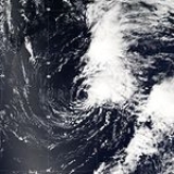
moved off the coast of Africa on September 1, which developed into Tropical Depression Thirteen early on September 6 to the southwest of the Cape Verde
islands. It quickly intensified into Tropical Storm Isabel, and it continued to gradually intensify within an area of light wind shear
and warm waters. Isabel strengthened to a hurricane on September 7, and the following day it attained major hurricane status
. Its intensity fluctuated over the subsequent days as it passed north of the Lesser Antilles, and it attained peak winds of 165 mph (270 km/h) on September 11, a Category 5 hurricane on the Saffir-Simpson Scale
. The hurricane oscillated between Category 4 and Category 5 status over the following four days, before weakening due to wind shear. On September 18 Isabel made landfall between Cape Lookout
and Ocracoke Island in North Carolina
with winds of 105 mph (165 km/h). It continued northwestward, becoming extratropical
over western Pennsylvania
before being absorbed by a larger storm over Ontario
on September 19.
Strong winds from Isabel extended from North Carolina
to New England
and westward to West Virginia
. The winds, combined with previous rainfall which moistened the soil, downed many trees and power lines across its path, leaving about 6 million electricity customers without power at some point. Coastal areas suffered from waves and its powerful storm surge, with areas in eastern North Carolina and southeast Virginia
reporting severe damage from both winds and the storm surge. Throughout its path, Isabel resulted in $3.6 billion in damage (2003 USD; $ USD) and 47 deaths, of which 16 were directly related to the storm's effects.
The governors of Pennsylvania
, West Virginia
, Maryland
, New Jersey
, and Delaware
declared states of emergencies. Isabel was the first major hurricane to threaten the Mid-Atlantic States
and the South since Hurricane Floyd
in September 1999. Isabel's greatest impact was due to flood
damage, the worst in some areas of Virginia
since 1972's Hurricane Agnes
. More than 60 million people were affected to some degree — a similar number to Floyd but more than any other hurricane in recent memory.
moved off the coast of Africa on September 6, and almost immediately it became associated with a broad surface circulation. With favorable upper-level winds the system quickly became better organized, and on September 8 it possessed enough organization to be classified as Tropical Depression Fourteen while located about 290 mi (465 km) southeast of the southernmost Cape Verde
islands. Initially the depression failed to maintain an inner core of deep convection, and despite its occurrence with nearby dry air, the depression was forecast to intensify to hurricane status due to anticipated favorable conditions.
In the hours subsequent to formation, the convection near the center decreased as the banding features dissipated. Dry air greatly increased over the depression, and by September 9 the system was not forecast to intensify past minimal tropical storm status. Later that day an upper-level low tracked southward to the west of the depression, which increased wind shear and caused a steady north-northwest motion for the depression. The circulation became elongated and separated from the convection as it passed just west of the Cape Verde Islands, where it brought heavy rainfall, and on September 10 the depression dissipated.
moved off the coast of Africa on September 14, and due to unfavorable wind shear
it initially remained disorganized. An area of convection increased in association with an upper-level low, and it developed into Tropical Depression Fifteen on September 24 to the southeast of Bermuda
. It steadily organized as it tracked northward, intensifying into Tropical Storm Juan on September 25 and attaining hurricane status on September 26. With warm waters and light wind shear, Juan reached peak winds of 105 mph (165 km/h) on September 27 about 635 mi (1,020 km) south of Halifax, Nova Scotia. It accelerated northward, weakening only slightly before moving ashore near Halifax on September 29 with winds of 100 mph (160 km/h). It quickly weakened while crossing the southern Canadian Maritimes before being absorbed by a large extratropical cyclone
over the Gulf of Saint Lawrence
.
The eyewall of Hurricane Juan was the first to directly cross over Halifax since a hurricane in August of 1893
; the cyclone became one of the most damaging tropical cyclones in modern history for the city. The hurricane produced a record storm surge
of 4.9 ft (1.5 m), which resulted in extensive flooding of the Halifax and Dartmouth waterfront properties. Strong winds caused widespread occurrences of falling trees, downed power lines, and damaged houses, and the hurricane was responsible for four direct deaths and four indirect deaths. More than 800,000 people were left without power. Nearly all wind-related damage occurred to the east of the storm track, and damage amounted to about $200 million (2003 CAD
($150 million 2003 USD; $ USD).
in the central tropical Atlantic on September 25. The storm moved northwestward until a weakness in the subtropical ridge
forced it eastward. Kate strengthened to a hurricane, turned sharply westward while moving around a mid-level low, and intensified to a 125 mph (205 km/h) major hurricane on October 4. Kate turned sharply northward around the periphery of an anticyclone
, weakened, and became extratropical after passing to the east of Newfoundland. The extratropical storm persisted for three days until losing its identity near Scandinavia
.
Kate threatened Atlantic Canada
just one week after Hurricane Juan
caused severe damage in Nova Scotia
. The storm had minimal effects on land, limited to moderately strong winds and heavy rainfall over Newfoundland; St. John's
reported 1.8 in (45 mm) on October 6, a record for the date. The interaction between Kate and a high pressure area to its north produced three to four ft (one m) waves along the coast of North Carolina
and New England
.
moved off the coast of Africa on September 17, which developed a low pressure area
on September 27 in the western Caribbean Sea
. It moved ashore along the Yucatán Peninsula
on September 29 and developed into an extratropical cyclone
as it interacted with a stationary cold front
. Deep convection increased, and it transitioned into Tropical Storm Larry by October 1. The storm drifted generally southward, and after reaching peak winds of 65 mph (100 km/h) it made landfall in the Mexican
state of Tabasco
on October 5, the first landfall in the state since Tropical Storm Brenda in 1973. The remnants of Larry crossed the Isthmus of Tehuantepec
, degenerating into a remnant low pressure area before dissipating on October 7 in the eastern Pacific Ocean.
The storm dropped heavy rainfall, peaking at 24.77 inches (629.2 mm) in Upper Juarez in southeastern Mexico
. The rainfall caused mudslides and damage, which coincided with the presence of two other tropical cyclones – Eastern Pacific tropical storm Nora and Olaf. Overall, the storm resulted in five deaths and $53.4 million in damage (2003 USD).
exited the coast of Africa on October 1 and moved westward. On October 8, thunderstorms spread across the Lesser Antilles, and the wave slowly organized. Rainfall reached 2.98 in (75 mm) in Christiansted
in Saint Croix
, and 7.13 in (181 mm) near Ponce, Puerto Rico
. Strong winds left around 29,000 people without power in northeastern Puerto Rico. The rainfall wrecked bridges in Las Piedras
and Guayama, and led to flooded streams, downed trees, and rockslides that closed four roads. One car was swept away, and a few houses were flooded. The damage total was at least $46,000 (2003 USD).
It turned northwestward through a weakness in the subtropical ridge
, and despite strong wind shear developed into Tropical Storm Mindy late on October 10 over eastern Dominican Republic
, with peak winds of 45 mph (75 km/h). It produced 2.63 in (60 mm) of rain in Santiago Rodríguez, which caused flooding and damaged 320 houses. Although forecast to intensify to 65 mph (105 km/h) winds, the storm weakened due to the wind shear. The center passed near the Turks and Caicos Islands
on October 11, and winds reached only 31 mph (50 km/h) at Grand Turk Island
. On October 12, Mindy weakened to a tropical depression, and later turned eastward due to an approaching short-wave trough
. Devoid of deep convection, the circulation dissipated on October 14 about 445 mi (715 km) south-southwest of Bermuda
. Mindy produced two to thee ft (0.6 to 0.9 m) swells along the U.S. Atlantic coast from Florida
through North Carolina
.
on October 13 in the central tropical Atlantic Ocean
, Nicholas slowly developed due to moderate levels of wind shear throughout its lifetime. Deep convection slowly organized, and Nicholas attained a peak intensity of 70 mph (110 km/h) on October 17. After moving west-northwestward for much of its lifetime, it turned northward and weakened due to increasing shear. The storm again turned to the west and briefly restrengthened, but after turning again to the north Nicholas transitioned to an extratropical cyclone on October 24. As an extratropical storm, Nicholas executed a large loop to the west, and after moving erratically for a week and organizing into a tropical low, it was absorbed by a non-tropical low. The low continued westward, crossed Florida
, and ultimately dissipated over the Gulf Coast of the United States
on November 5.
Nicholas had no impact as a tropical cyclone, and impact from the low that absorbed the storm was limited to rainfall, gusty winds, and rough surf. The low that absorbed the storm nearly developed into a tropical cyclone, which would have been called Odette. However, moderate wind shear
prevented further development.
in 1984, that formed on December 4 in the southwest Caribbean Sea. Odette strengthened and made landfall near Cabo Falso in the Dominican Republic on December 6 as a moderately strong tropical storm. A day later, Odette became extratropical, and eventually merged with a cold front.
Eight deaths were directly attributed to this tropical storm in the Dominican Republic
due to mudslides or flash flooding. In addition, two deaths were indirectly caused by the storm. Approximately 35% of the nation's banana
crop was destroyed. Light to moderate rainfall was reported in Puerto Rico
.
developed and was moving southward, isolated from the Westerlies
. Convection developed near the center, and the system organized into a subtropical storm
late on December 7, about 835 mi (1340 km) south-southwest of the Azores
. The system moved southwestward over warmer waters, and deep convection continued to organize over the center. Banding features also increased, and the National Hurricane Center declared the system as Tropical Storm Peter on December 9, about 980 mi (1580 km) northwest of the Cape Verde
islands. With the development of Peter and Odette, 2003 became the first year since 1887
that two storms developed in the month of December. Peter also made 2003 the sixth most active season on record, and is one of only six storms to reach the "P" name since naming began in 1950.
Initially, the National Hurricane Center did not anticipate strengthening; however, Peter intensified to winds of 70 mph (110 km/h) late on December 9, after an eye feature
developed. Usually that would indicate hurricane intensity, but as the eye was short-lived, Peter remained a tropical storm. It turned northward ahead of the same frontal system
that absorbed Tropical Storm Odette
, and the combination of strong upper-level winds and cooler water temperatures caused quick weakening. By December 10, Peter degenerated into a tropical depression, and after turning northeastward it was absorbed by the cold front the next day.
The table on the right shows the ACE
for each storm in the season. The ACE is, broadly speaking, a measure of the power of the hurricane multiplied by the length of time it existed for, so hurricanes that lasted a long time (such as Isabel
and Fabian
) have higher ACEs. Isabel was one of the very few hurricanes since 1950 to have an ACE of over 50 104 kt2, and was one of just 7 to have an ACE of over 60.
2003 Atlantic hurricane season
The 2003 Atlantic hurricane season was an active Atlantic hurricane season with tropical activity before and after the official bounds of the season – the first such occurrence in 50 years. The season produced 21 tropical cyclones, of which 16 developed into named storms; seven...
officially began June 1, 2003 and officially ended on November 30, 2003. These dates conventionally delimit the period of each year when most tropical cyclone
Tropical cyclone
A tropical cyclone is a storm system characterized by a large low-pressure center and numerous thunderstorms that produce strong winds and heavy rain. Tropical cyclones strengthen when water evaporated from the ocean is released as the saturated air rises, resulting in condensation of water vapor...
s form in the Atlantic basin
Atlantic Basin
The Atlantic Basin is the Atlantic Ocean.Atlantic Basin may also refer to:* Atlantic Basin Iron Works, an ironworks that operated in Brooklyn, New York, in the early to mid-20th century...
, although effectively the season extended from April through December due to out of season storm activity.
The 2003 season was tied for the sixth most active season on record. Sixteen tropical storms formed, of which seven became hurricanes; of these, three strengthened into major hurricanes, of which one reached Category 5 strength, the highest categorization for Atlantic hurricane
Atlantic hurricane
North Atlantic tropical cyclones usually form in the northern hemisphere summer or fall. Tropical cyclones can be categorized by intensity. Tropical storms have one-minute maximum sustained winds of at least 39 mph , while hurricanes have one-minute maximum sustained exceeding 74 mph...
s on the Saffir-Simpson Hurricane Scale
Saffir-Simpson Hurricane Scale
The Saffir–Simpson Hurricane Scale , or the Saffir–Simpson Hurricane Wind Scale , classifies hurricanes — Western Hemisphere tropical cyclones that exceed the intensities of tropical depressions and tropical storms — into five categories distinguished by the intensities of their sustained winds...
. The most notable storms of the season were hurricanes Fabian
Hurricane Fabian
Hurricane Fabian was a powerful Cape Verde-type hurricane that hit Bermuda in early September during the 2003 Atlantic hurricane season. Fabian, the sixth named storm, fourth hurricane, and first major hurricane of the season, developed from a tropical wave in the tropical Atlantic Ocean on August 25...
, Isabel
Hurricane Isabel
Hurricane Isabel was the costliest and deadliest hurricane in the 2003 Atlantic hurricane season. The ninth named storm, fifth hurricane, and second major hurricane of the season, Isabel formed near the Cape Verde Islands from a tropical wave on September 6 in the tropical Atlantic Ocean...
, and Juan
Hurricane Juan
Hurricane Juan was a significant hurricane that struck the southern part of Atlantic Canada in late September 2003. It was the tenth named storm and the sixth hurricane of the 2003 Atlantic hurricane season. Juan formed southeast of Bermuda on September 24, 2003 out of a tropical wave that tracked...
, all of which were retired. The total season impact resulted in $4.4 billion (2003 USD; $ USD) in damage and 92 total deaths.
| Tropical cyclone A tropical cyclone is a storm system characterized by a large low-pressure center and numerous thunderstorms that produce strong winds and heavy rain. Tropical cyclones strengthen when water evaporated from the ocean is released as the saturated air rises, resulting in condensation of water vapor... |
||||||||||||||||||||||||||||||||||||||||||||||||||
EWLINE
|
table cellpadding="1" cellspacing="0" style="text-align: left; margin: auto; font-size: 90%; background:transparent;"> | |||||||||||||||||||||||||||||||||||||||||||||||||
|
|
|
|
|
|
| ||||||||||||||||||||||||||||||||||||||||||||
Tropical Storm Ana
A non-tropical low pressure areaLow pressure area
A low-pressure area, or "low", is a region where the atmospheric pressure at sea level is below that of surrounding locations. Low-pressure systems form under areas of wind divergence which occur in upper levels of the troposphere. The formation process of a low-pressure area is known as...
developed about 240 mi (390 km) south-southwest of Bermuda
Bermuda
Bermuda is a British overseas territory in the North Atlantic Ocean. Located off the east coast of the United States, its nearest landmass is Cape Hatteras, North Carolina, about to the west-northwest. It is about south of Halifax, Nova Scotia, Canada, and northeast of Miami, Florida...
on April 18 through the interaction of an upper-level trough
Trough (meteorology)
A trough is an elongated region of relatively low atmospheric pressure, often associated with fronts.Unlike fronts, there is not a universal symbol for a trough on a weather chart. The weather charts in some countries or regions mark troughs by a line. In the United States, a trough may be marked...
and a surface frontal trough
Trough (meteorology)
A trough is an elongated region of relatively low atmospheric pressure, often associated with fronts.Unlike fronts, there is not a universal symbol for a trough on a weather chart. The weather charts in some countries or regions mark troughs by a line. In the United States, a trough may be marked...
. It tracked northwestward at first, then turned to the southeast. After developing centralized convection, the system developed into Subtropical Storm Ana on April 20 to the west of Bermuda. It tracked east-southeastward and organized, and on April 21 it transitioned into a tropical cyclone with peak winds of 60 mph (95 km/h), after developing an upper-level warm core. Increased wind shear
Wind shear
Wind shear, sometimes referred to as windshear or wind gradient, is a difference in wind speed and direction over a relatively short distance in the atmosphere...
caused fluctuations in intensity and a steady weakening trend, and on April 24 the center of Ana merged with an approaching cold front
Cold front
A cold front is defined as the leading edge of a cooler mass of air, replacing a warmer mass of air.-Development of cold front:The cooler and denser air wedges under the less-dense warmer air, lifting it...
, thus signaling the completion of extratropical transition
Extratropical cyclone
Extratropical cyclones, sometimes called mid-latitude cyclones or wave cyclones, are a group of cyclones defined as synoptic scale low pressure weather systems that occur in the middle latitudes of the Earth having neither tropical nor polar characteristics, and are connected with fronts and...
. The extratropical remnants continued east-northeastward, and on April 27 the gale was absorbed within the cold front.
The cyclone is most notable for being the only Atlantic tropical cyclone in the month of April. When Ana became a Subtropical Storm, it became the second subtropical cyclone on record in the month, after a storm in 1992
Subtropical Storm One (1992)
Subtropical Storm One in 1992 was the first recorded Atlantic subtropical cyclone during the month of April. It formed on April 21 about 600 miles southeast of Bermuda, and tracking northwestward reached subtropical storm status on April 22. The cyclone attained peak winds of 50 mph ...
. Ana dropped 2.63 in (67 mm) of rainfall in Bermuda over a period of several days. Increased swells from the storm caused two drowning deaths in southeastern Florida
Florida
Florida is a state in the southeastern United States, located on the nation's Atlantic and Gulf coasts. It is bordered to the west by the Gulf of Mexico, to the north by Alabama and Georgia and to the east by the Atlantic Ocean. With a population of 18,801,310 as measured by the 2010 census, it...
when a boat capsized. The remnants of the storm brought light rainfall to the Azores and the United Kingdom, though no significant damage was reported.
Tropical Depression Two
A tropical waveTropical wave
Tropical waves, easterly waves, or tropical easterly waves, also known as African easterly waves in the Atlantic region, are a type of atmospheric trough, an elongated area of relatively low air pressure, oriented north to south, which move from east to west across the tropics causing areas of...
moved off the coast of Africa on June 6. Tracking westward at a low latitude, a disturbance along the wave axis became better organized on June 9, with reasonable favorable environmental conditions despite the time of year. Initially lacking a well-defined low-level circulation, convection increased further on June 10, and the system was declared Tropical Depression Two early on June 11 in the central tropical Atlantic Ocean. The depression was only the third tropical cyclone on record to develop in the month of June to the east of the Lesser Antilles
Lesser Antilles
The Lesser Antilles are a long, partly volcanic island arc in the Western Hemisphere. Most of its islands form the eastern boundary of the Caribbean Sea with the Atlantic Ocean, with the remainder located in the southern Caribbean just north of South America...
; the others were Ana in 1979, and a Storm in 1933.
Initially, the depression was forecast to attain tropical storm status, maintaining good outflow
Outflow (meteorology)
Outflow, in meteorology, is air that flows outwards from a storm system. It is associated with ridging, or anticyclonic flow. In the low levels of the troposphere, outflow radiates from thunderstorms in the form of a wedge of rain-cooled air, which is visible as a thin rope-like cloud on weather...
and some banding features around the system. Around 0900 UTC on June 11 satellite-based intensity estimates indicated the depression was near tropical storm status. However, the convection subsequently diminished and became displaced to the northeast of the center, and late on June 11 the depression degenerated into an open tropical wave about 950 mi (1535 km) east-southeast of Barbados
Barbados
Barbados is an island country in the Lesser Antilles. It is in length and as much as in width, amounting to . It is situated in the western area of the North Atlantic and 100 kilometres east of the Windward Islands and the Caribbean Sea; therein, it is about east of the islands of Saint...
. The tropical wave remained well-defined with a well-defined low-level vorticity, though strong wind shear
Wind shear
Wind shear, sometimes referred to as windshear or wind gradient, is a difference in wind speed and direction over a relatively short distance in the atmosphere...
prevented tropical redevelopment. On June 13 its remnants passed through the Lesser Antilles
Lesser Antilles
The Lesser Antilles are a long, partly volcanic island arc in the Western Hemisphere. Most of its islands form the eastern boundary of the Caribbean Sea with the Atlantic Ocean, with the remainder located in the southern Caribbean just north of South America...
, and the wave continued westward through the Caribbean Sea
Caribbean Sea
The Caribbean Sea is a sea of the Atlantic Ocean located in the tropics of the Western hemisphere. It is bounded by Mexico and Central America to the west and southwest, to the north by the Greater Antilles, and to the east by the Lesser Antilles....
.
Tropical Storm Bill
Tropical Storm Bill developed from a tropical waveTropical wave
Tropical waves, easterly waves, or tropical easterly waves, also known as African easterly waves in the Atlantic region, are a type of atmospheric trough, an elongated area of relatively low air pressure, oriented north to south, which move from east to west across the tropics causing areas of...
on June 29 to the north of the Yucatán Peninsula
Yucatán Peninsula
The Yucatán Peninsula, in southeastern Mexico, separates the Caribbean Sea from the Gulf of Mexico, with the northern coastline on the Yucatán Channel...
. It slowly organized as it moved northward, and reached a peak of 60 mph (95 km/h) shortly before making landfall 27 mi (43 km) west of Chauvin
Chauvin, Louisiana
Chauvin is a census-designated place in Terrebonne Parish, Louisiana, United States. The population was 3,229 at the 2000 census. It is part of the Houma–Bayou Cane–Thibodaux Metropolitan Statistical Area.-Geography:...
, Louisiana
Louisiana
Louisiana is a state located in the southern region of the United States of America. Its capital is Baton Rouge and largest city is New Orleans. Louisiana is the only state in the U.S. with political subdivisions termed parishes, which are local governments equivalent to counties...
. Bill quickly weakened over land, and as it accelerated to the northeast, moisture from the storm, combined with cold air from an approaching cold front
Surface weather analysis
Surface weather analysis is a special type of weather map that provides a view of weather elements over a geographical area at a specified time based on information from ground-based weather stations...
, produced an outbreak of 34 tornado
Tornado
A tornado is a violent, dangerous, rotating column of air that is in contact with both the surface of the earth and a cumulonimbus cloud or, in rare cases, the base of a cumulus cloud. They are often referred to as a twister or a cyclone, although the word cyclone is used in meteorology in a wider...
es. Bill became extratropical on July 2, and was absorbed by the cold front later that day.
Upon making landfall on Louisiana
Louisiana
Louisiana is a state located in the southern region of the United States of America. Its capital is Baton Rouge and largest city is New Orleans. Louisiana is the only state in the U.S. with political subdivisions termed parishes, which are local governments equivalent to counties...
, the storm produced a moderate storm surge
Storm surge
A storm surge is an offshore rise of water associated with a low pressure weather system, typically tropical cyclones and strong extratropical cyclones. Storm surges are caused primarily by high winds pushing on the ocean's surface. The wind causes the water to pile up higher than the ordinary sea...
, causing tidal flood
Flood
A flood is an overflow of an expanse of water that submerges land. The EU Floods directive defines a flood as a temporary covering by water of land not normally covered by water...
ing. In a city in the northeastern portion of the state, the surge breached a levee
Levee
A levee, levée, dike , embankment, floodbank or stopbank is an elongated naturally occurring ridge or artificially constructed fill or wall, which regulates water levels...
, which flooded many homes in the town. Moderate winds combined with wet soil
Soil
Soil is a natural body consisting of layers of mineral constituents of variable thicknesses, which differ from the parent materials in their morphological, physical, chemical, and mineralogical characteristics...
knocked down trees, which then hit a few houses and power lines, and left hundreds of thousands without electric power
Electric power
Electric power is the rate at which electric energy is transferred by an electric circuit. The SI unit of power is the watt.-Circuits:Electric power, like mechanical power, is represented by the letter P in electrical equations...
. Further inland, tornadoes from the storm produced localized moderate damage. Throughout its path, Tropical Storm Bill caused around $50 million in damage (2003 USD, $ USD) and four deaths.
Hurricane Claudette
A well-organized tropical waveTropical wave
Tropical waves, easterly waves, or tropical easterly waves, also known as African easterly waves in the Atlantic region, are a type of atmospheric trough, an elongated area of relatively low air pressure, oriented north to south, which move from east to west across the tropics causing areas of...
tracked quickly through the Lesser Antilles
Lesser Antilles
The Lesser Antilles are a long, partly volcanic island arc in the Western Hemisphere. Most of its islands form the eastern boundary of the Caribbean Sea with the Atlantic Ocean, with the remainder located in the southern Caribbean just north of South America...
on July 7, producing tropical storm force winds but failing to attain a low-level circulation. After organizing in the Caribbean Sea
Caribbean Sea
The Caribbean Sea is a sea of the Atlantic Ocean located in the tropics of the Western hemisphere. It is bounded by Mexico and Central America to the west and southwest, to the north by the Greater Antilles, and to the east by the Lesser Antilles....
, it developed into Tropical Storm Claudette to the south of the Dominican Republic
Dominican Republic
The Dominican Republic is a nation on the island of La Hispaniola, part of the Greater Antilles archipelago in the Caribbean region. The western third of the island is occupied by the nation of Haiti, making Hispaniola one of two Caribbean islands that are shared by two countries...
on July 8. Its intensity fluctuated over the subsequent days, attaining hurricane status briefly on July 10 before weakening and hitting Puerto Morelos
Puerto Morelos
Puerto Morelos is a town and sea port in Quintana Roo, Mexico's easternmost state, on the Yucatán Peninsula. The town is at the southern end of the municipality of Benito Juárez in the northeast of the state, about 36 km south of the resort city of Cancún...
on the Yucatán Peninsula
Yucatán Peninsula
The Yucatán Peninsula, in southeastern Mexico, separates the Caribbean Sea from the Gulf of Mexico, with the northern coastline on the Yucatán Channel...
on July 11 as a tropical storm. The storm remained disorganized due to moderate wind shear
Wind shear
Wind shear, sometimes referred to as windshear or wind gradient, is a difference in wind speed and direction over a relatively short distance in the atmosphere...
, though after turning west-northwestward into an area of lighter shear, it re-attained hurricane status on July 15 off the coast of Texas
Texas
Texas is the second largest U.S. state by both area and population, and the largest state by area in the contiguous United States.The name, based on the Caddo word "Tejas" meaning "friends" or "allies", was applied by the Spanish to the Caddo themselves and to the region of their settlement in...
; it intensified quickly and made landfall
Landfall (meteorology)
Landfall is the event of a tropical cyclone or a waterspout coming onto land after being over water. When a waterspout makes landfall it is reclassified as a tornado, which can then cause damage inland...
on Matagorda Island
Matagorda Island
Matagorda Island, Spanish for "thick brush," is a 38 mile long barrier island on the Texas Gulf coast, about seven miles south of Port O'Connor, in the southernmost part of Calhoun County. The island is oriented generally northeast-southwest, with the Gulf of Mexico on the east and south, and...
with peak winds of 90 mph (145 km/h). It slowly weakened after moving ashore, tracking across northern Tamaulipas
Tamaulipas
Tamaulipas officially Estado Libre y Soberano de Tamaulipas is one of the 31 states which, with the Federal District, comprise the 32 Federal Entities of Mexico. It is divided in 43 municipalities and its capital city is Ciudad Victoria. The capital city was named after Guadalupe Victoria, the...
before dissipating in northwestern Chihuahua.
The precursor cyclone caused light damage in the Lesser Antilles, and waves from the hurricane caused an indirect death off of Florida
Florida
Florida is a state in the southeastern United States, located on the nation's Atlantic and Gulf coasts. It is bordered to the west by the Gulf of Mexico, to the north by Alabama and Georgia and to the east by the Atlantic Ocean. With a population of 18,801,310 as measured by the 2010 census, it...
. Widespread flooding and gusty winds destroyed or severely damaged 412 buildings in southeast Texas, with a further 1,346 buildings suffering lighter impact. The hurricane caused locally severe beach erosion along the coast. High winds downed many trees along the coast, causing one direct and one indirect death. Damage was estimated at $180 million (2003 USD, $ USD).
Hurricane Danny
A tropical waveTropical wave
Tropical waves, easterly waves, or tropical easterly waves, also known as African easterly waves in the Atlantic region, are a type of atmospheric trough, an elongated area of relatively low air pressure, oriented north to south, which move from east to west across the tropics causing areas of...
moved off the coast of Africa on July 9. The northern portion of the wave tracked to the west-northwest, and on July 13 an area of convection developed along the wave axis. The system slowly organized, and after a closed low-level circulation developed, the system was classified as Tropical Depression Five about 630 mi (1020 km) east of Bermuda
Bermuda
Bermuda is a British overseas territory in the North Atlantic Ocean. Located off the east coast of the United States, its nearest landmass is Cape Hatteras, North Carolina, about to the west-northwest. It is about south of Halifax, Nova Scotia, Canada, and northeast of Miami, Florida...
. It quickly organized, becoming Tropical Storm Danny a day after forming. Tracking around the periphery of an anticyclone
Ridge (meteorology)
A ridge is an elongated region of relatively high atmospheric pressure, the opposite of a trough....
, the storm moved northwestward before turning north and later northeastward. Despite being located at a high latitude, Danny continued to strengthen due to unusually warm water temperatures, and on July 19 it attained hurricane status about 525 mi (850 km) south of St. John's, Newfoundland and Labrador
St. John's, Newfoundland and Labrador
St. John's is the capital and largest city in Newfoundland and Labrador, and is the oldest English-founded city in North America. It is located on the eastern tip of the Avalon Peninsula on the island of Newfoundland. With a population of 192,326 as of July 1, 2010, the St...
.
Wind shear
Wind shear
Wind shear, sometimes referred to as windshear or wind gradient, is a difference in wind speed and direction over a relatively short distance in the atmosphere...
increased the next day as the hurricane turned eastward, causing a steady weakening trend that was accelerated after crossing into an area of cooler water temperatures. By July 20 the cyclone had turned to the southeast and weakened to tropical depression status, and on July 21 it degenerated into a remnant low pressure area. The remnants of Danny tracked erratically southwestward before dissipating on July 27 about 630 mi (1015 km) east of where it originally developed. There were no reports of damages or casualties associated with Danny.
Tropical Depression Six
A tropical waveTropical wave
Tropical waves, easterly waves, or tropical easterly waves, also known as African easterly waves in the Atlantic region, are a type of atmospheric trough, an elongated area of relatively low air pressure, oriented north to south, which move from east to west across the tropics causing areas of...
moved westward off the coast of Africa on July 14. After tracking steadily westward, an area of thunderstorms became more concentrated as its upper-level environment became more favorable, and late on July 19 the National Hurricane Center classified it as Tropical Depression Six while it was located about 1035 mi (1675 km) east of the Lesser Antilles
Lesser Antilles
The Lesser Antilles are a long, partly volcanic island arc in the Western Hemisphere. Most of its islands form the eastern boundary of the Caribbean Sea with the Atlantic Ocean, with the remainder located in the southern Caribbean just north of South America...
. Upon being classified as a tropical cyclone, the depression maintained two ill-defined hooking bands to its north and south, and was originally forecast to attain hurricane status before passing through the Lesser Antilles. With warm waters and very light wind shear forecast, its environmental conditions met four out of five parameters for rapid intensification
Rapid deepening
Rapid deepening, also known as rapid intensification, is a meteorological condition that occurs when the minimum sea-level atmospheric pressure of a tropical cyclone decreases drastically in a short period of time. The National Weather Service describes rapid deepening as a decrease of...
. Subsequently, convection diminished as the result of cold air inflow and instability from a disturbance to its southeast.
With a fast forward speed, confirmation of a low-level circulation on July 20 became difficult. Convection increased in curvature on July 21, and several islands in the Lesser Antilles issued tropical storm warnings and watches
Tropical cyclone warnings and watches
Warnings and watches are two levels of alert issued by national weather forecasting bodies to coastal areas threatened by the imminent approach of a tropical cyclone of tropical storm or hurricane intensity. They are notices to the local population and civil authorities to make appropriate...
. After it passed north of Barbados
Barbados
Barbados is an island country in the Lesser Antilles. It is in length and as much as in width, amounting to . It is situated in the western area of the North Atlantic and 100 kilometres east of the Windward Islands and the Caribbean Sea; therein, it is about east of the islands of Saint...
, a Hurricane Hunters
Hurricane Hunters
The Hurricane Hunters are aircraft that fly into tropical cyclones in the North Atlantic Ocean and Northeastern Pacific Ocean for the specific purpose of directly measuring weather data in and around those storms. In the United States, the Air Force, Navy, and NOAA units have all participated in...
flight failed to report a closed low-level circulation, and it is estimated the depression degenerated into an open tropical wave late on July 21. The remnants brought a few showers to the Lesser Antilles, and after tracking into the Caribbean Sea
Caribbean Sea
The Caribbean Sea is a sea of the Atlantic Ocean located in the tropics of the Western hemisphere. It is bounded by Mexico and Central America to the west and southwest, to the north by the Greater Antilles, and to the east by the Lesser Antilles....
redevelopment was prevented by increased wind shear. The northern portion of the wave axis split and developed into Tropical Depression Seven.
Tropical Depression Seven
A tropical wave interacted with an upper-level low to develop an area of deep convection near HispaniolaHispaniola
Hispaniola is a major island in the Caribbean, containing the two sovereign states of the Dominican Republic and Haiti. The island is located between the islands of Cuba to the west and Puerto Rico to the east, within the hurricane belt...
on July 23. A mid- to lower-level circulation developed within the system at it tracked generally north-northwestward, and based on surface and satellite observations, it is estimated the system developed into Tropical Depression Seven at 1200 UTC
Coordinated Universal Time
Coordinated Universal Time is the primary time standard by which the world regulates clocks and time. It is one of several closely related successors to Greenwich Mean Time. Computer servers, online services and other entities that rely on having a universally accepted time use UTC for that purpose...
on July 25 about 60 mi (95 km) east of Daytona Beach
Daytona Beach, Florida
Daytona Beach is a city in Volusia County, Florida, USA. According to 2008 U.S. Census Bureau estimates, the city has a population of 64,211. Daytona Beach is a principal city of the Deltona – Daytona Beach – Ormond Beach, Florida Metropolitan Statistical Area, which the census bureau estimated had...
, Florida
Florida
Florida is a state in the southeastern United States, located on the nation's Atlantic and Gulf coasts. It is bordered to the west by the Gulf of Mexico, to the north by Alabama and Georgia and to the east by the Atlantic Ocean. With a population of 18,801,310 as measured by the 2010 census, it...
. The system was embedded in an environment characterized by high surface pressures. Tracking through an area of cool water temperatures, as well as unfavorable upper-level winds, the depression failed to achieve winds greater than 35 mph (55 km/h). Early on July 26 it moved ashore on St. Catherines Island
St. Catherines Island
St. Catherines Island, also known as Santa Catalina, is one of the Sea Islands or Golden Isles on the coast of the U.S. state of Georgia, 50 miles south of Savannah in Liberty County. The island is ten miles long and from one to three miles wide, located between St. Catherine's Sound and Sapelo...
, Georgia
Georgia (U.S. state)
Georgia is a state located in the southeastern United States. It was established in 1732, the last of the original Thirteen Colonies. The state is named after King George II of Great Britain. Georgia was the fourth state to ratify the United States Constitution, on January 2, 1788...
, and after steadily weakening over land it dissipated on July 27. The depression dropped light to moderate rainfall from Florida
Florida
Florida is a state in the southeastern United States, located on the nation's Atlantic and Gulf coasts. It is bordered to the west by the Gulf of Mexico, to the north by Alabama and Georgia and to the east by the Atlantic Ocean. With a population of 18,801,310 as measured by the 2010 census, it...
to the coast of North Carolina
North Carolina
North Carolina is a state located in the southeastern United States. The state borders South Carolina and Georgia to the south, Tennessee to the west and Virginia to the north. North Carolina contains 100 counties. Its capital is Raleigh, and its largest city is Charlotte...
, peaking at 5.17 in (131 mm) in Savannah
Savannah, Georgia
Savannah is the largest city and the county seat of Chatham County, in the U.S. state of Georgia. Established in 1733, the city of Savannah was the colonial capital of the Province of Georgia and later the first state capital of Georgia. Today Savannah is an industrial center and an important...
, Georgia
Georgia (U.S. state)
Georgia is a state located in the southeastern United States. It was established in 1732, the last of the original Thirteen Colonies. The state is named after King George II of Great Britain. Georgia was the fourth state to ratify the United States Constitution, on January 2, 1788...
. There were no reports of damage or casualties associated with this depression.
Hurricane Erika
The precursor system to Hurricane Erika was first observed as a non-tropical low on August 9 about 1150 mi (1860 km) east of Bermuda. It tracked quickly southwestward then westward in tandem with an upper-level low, which prevented tropical development. On August 13 an area of convection increased as it passed through the Bahamas, and while crossing Florida a circulation built toward the surface; it is estimated the system developed into Tropical Storm Erika on August 14 about 85 mi (140 km) west-southwest of Fort MyersFort Myers, Florida
Fort Myers is the county seat and commercial center of Lee County, Florida, United States. Its population was 62,298 in the 2010 census, a 29.23 percent increase over the 2000 figure....
, Florida. A strong ridge
Ridge (meteorology)
A ridge is an elongated region of relatively high atmospheric pressure, the opposite of a trough....
caused the storm to continue quickly westward, and the system gradually strengthened and organized. By August 15 its forward motion slowed, allowing the convection to organize into curved rainbands, and late in the day an eye feature
Eye (cyclone)
The eye is a region of mostly calm weather found at the center of strong tropical cyclones. The eye of a storm is a roughly circular area and typically 30–65 km in diameter. It is surrounded by the eyewall, a ring of towering thunderstorms where the second most severe weather of a cyclone...
began developing. Tropical Storm Erika attained hurricane status at around 1030 UTC
Coordinated Universal Time
Coordinated Universal Time is the primary time standard by which the world regulates clocks and time. It is one of several closely related successors to Greenwich Mean Time. Computer servers, online services and other entities that rely on having a universally accepted time use UTC for that purpose...
as it was moving ashore in northeastern Tamaulipas; operationally it was not classified as a hurricane, due to lack of data. The winds rapidly decreased as it tracked across the mountainous terrain of northeastern Mexico
Mexico
The United Mexican States , commonly known as Mexico , is a federal constitutional republic in North America. It is bordered on the north by the United States; on the south and west by the Pacific Ocean; on the southeast by Guatemala, Belize, and the Caribbean Sea; and on the east by the Gulf of...
, and early on August 17 the cyclone dissipated.
The hurricane dropped light to moderate rainfall along its path, which caused some flooding; in Montemorelos
Montemorelos
Montemorelos is a city and surrounding municipality of 53,854 inhabitants located in the Northern Mexican state of Nuevo León, in the valley of the Pilon River...
in Nuevo León
Nuevo León
Nuevo León It is located in Northeastern Mexico. It is bordered by the states of Tamaulipas to the north and east, San Luis Potosí to the south, and Coahuila to the west. To the north, Nuevo León has a 15 kilometer stretch of the U.S.-Mexico border adjacent to the U.S...
, two people died after being swept away by floodwaters. Several mudslides were reported, which left numerous highways blocked or impassable. In southern Texas, the hurricane caused light winds and minor damage, with no reports of deaths or injuries in the United States.
Tropical Depression Nine
A strong tropical waveTropical wave
Tropical waves, easterly waves, or tropical easterly waves, also known as African easterly waves in the Atlantic region, are a type of atmospheric trough, an elongated area of relatively low air pressure, oriented north to south, which move from east to west across the tropics causing areas of...
moved off the coast of Africa on August 14, and after tracking steadily westward an area of convection began to become better organized on August 18. After it tracked through the Lesser Antilles, it developed into Tropical Depression Nine on August 21 to the south of Puerto Rico
Puerto Rico
Puerto Rico , officially the Commonwealth of Puerto Rico , is an unincorporated territory of the United States, located in the northeastern Caribbean, east of the Dominican Republic and west of both the United States Virgin Islands and the British Virgin Islands.Puerto Rico comprises an...
. The depression quickly showed signs of organization, and forecasters predicted the depression to intensify to a strong tropical storm. However, strong southwesterly wind shear
Wind shear
Wind shear, sometimes referred to as windshear or wind gradient, is a difference in wind speed and direction over a relatively short distance in the atmosphere...
unexpectedly became established over the system, and the depression degenerated into a tropical wave late on August 22 to the south of the eastern tip of the Dominican Republic
Dominican Republic
The Dominican Republic is a nation on the island of La Hispaniola, part of the Greater Antilles archipelago in the Caribbean region. The western third of the island is occupied by the nation of Haiti, making Hispaniola one of two Caribbean islands that are shared by two countries...
.
The remnants of the depression dropped light to moderate precipitation in the Dominican Republic, which caused flooding and overflown rivers. More than 100 houses were flooded, and some crop damage was reported. The rainfall was welcome in the country, as conditions were dry in the preceding months. Flooding was also reported in eastern Jamaica
Jamaica
Jamaica is an island nation of the Greater Antilles, in length, up to in width and 10,990 square kilometres in area. It is situated in the Caribbean Sea, about south of Cuba, and west of Hispaniola, the island harbouring the nation-states Haiti and the Dominican Republic...
, though damage there, if any, is unknown.
Hurricane Fabian
On August 25, a tropical waveTropical wave
Tropical waves, easterly waves, or tropical easterly waves, also known as African easterly waves in the Atlantic region, are a type of atmospheric trough, an elongated area of relatively low air pressure, oriented north to south, which move from east to west across the tropics causing areas of...
emerged off the coast of Africa, and two days later developed enough organized convection to develop into Tropical Depression Ten. Tracking through warm waters and low vertical shear, the depression was named Tropical Storm Fabian on August 28. On August 30, the storm intensified into a hurricane, and it quickly strengthened to attain major hurricane status late that day; on September 1 Fabian reached its peak intensity of 145 mph (230 km/h). The hurricane turned to the north and gradually weakened before passing 14 mi (23 km) west of Bermuda on September 5 with winds of 115 mph (180 km/h). The cyclone accelerated northeastward into an environment of unfavorable conditions, becoming an extratropical cyclone
Extratropical cyclone
Extratropical cyclones, sometimes called mid-latitude cyclones or wave cyclones, are a group of cyclones defined as synoptic scale low pressure weather systems that occur in the middle latitudes of the Earth having neither tropical nor polar characteristics, and are connected with fronts and...
on September 8; two days later it merged with another extratropical storm between southern Greenland
Greenland
Greenland is an autonomous country within the Kingdom of Denmark, located between the Arctic and Atlantic Oceans, east of the Canadian Arctic Archipelago. Though physiographically a part of the continent of North America, Greenland has been politically and culturally associated with Europe for...
and Iceland
Iceland
Iceland , described as the Republic of Iceland, is a Nordic and European island country in the North Atlantic Ocean, on the Mid-Atlantic Ridge. Iceland also refers to the main island of the country, which contains almost all the population and almost all the land area. The country has a population...
.
Strong waves caused extensive damage to the Bermuda coastline, destroying 10 nests of the endangered Bermuda Petrel
Bermuda Petrel
The Bermuda Petrel, Pterodroma cahow, is a gadfly petrel. Commonly known in Bermuda as the Cahow, a name derived from its eerie cries, this nocturnal ground-nesting seabird is the national bird of Bermuda, and a symbol of hope for nature conservation. It was thought extinct for 330 years...
. The storm surge from the hurricane stranded one vehicle with three police officers and another with a resident on the causeway
The Causeway, Bermuda
The Causeway is a narrow strip of reclaimed land and bridges in the north of Bermuda linking Hamilton Parish on the mainland in the southwest and Bermuda International Airport on St. David's Island in St. George's Parish in the northeast, which are otherwise divided by Castle Harbour.The need for...
between St. George's Parish
St. George's Parish, Bermuda
St. George's Parish is one of the nine parishes of Bermuda. It is named after the founder of the Bermuda colony, Admiral Sir George Somers.It is located in the north-easternmost part of the island chain, containing a small part of the main island around Tucker's Town and the Tucker's Town...
and St. David's Island
St. David's Island, Bermuda
St. David's Island is one of the main islands of Bermuda. It is located in the far north of the territory, one of the two similarly sized islands that makeup the majority of St...
, later washing both vehicles into Castle Harbour
Castle Harbour, Bermuda
Castle Harbour is a large natural harbour in Bermuda. It is located between the northeastern end of the main island and St. David's Island. Originally called Southampton Port, it was renamed as a result of its heavy fortification in the early decades of the Seventeenth century.-Geography:A gem of...
; all four were killed. Strong winds left about 25,000 people without power on the island, and also caused severe damage to vegetation. The strong winds damaged or destroyed the roofs of numerous buildings on Bermuda, Damage on the island totaled $300 million (2003 USD, $ USD). Elsewhere, strong waves from the hurricane killed a surfer in North Carolina
North Carolina
North Carolina is a state located in the southeastern United States. The state borders South Carolina and Georgia to the south, Tennessee to the west and Virginia to the north. North Carolina contains 100 counties. Its capital is Raleigh, and its largest city is Charlotte...
and caused three deaths off of Newfoundland
Newfoundland and Labrador
Newfoundland and Labrador is the easternmost province of Canada. Situated in the country's Atlantic region, it incorporates the island of Newfoundland and mainland Labrador with a combined area of . As of April 2011, the province's estimated population is 508,400...
when a fishing vessel sank.
Tropical Storm Grace
A strong tropical waveTropical wave
Tropical waves, easterly waves, or tropical easterly waves, also known as African easterly waves in the Atlantic region, are a type of atmospheric trough, an elongated area of relatively low air pressure, oriented north to south, which move from east to west across the tropics causing areas of...
accompanied with a low pressure system moved off the coast of Africa on August 19. It moved quickly westward, failing to organize significantly, and developed a surface low pressure area
Low pressure area
A low-pressure area, or "low", is a region where the atmospheric pressure at sea level is below that of surrounding locations. Low-pressure systems form under areas of wind divergence which occur in upper levels of the troposphere. The formation process of a low-pressure area is known as...
on August 29 in the Gulf of Mexico
Gulf of Mexico
The Gulf of Mexico is a partially landlocked ocean basin largely surrounded by the North American continent and the island of Cuba. It is bounded on the northeast, north and northwest by the Gulf Coast of the United States, on the southwest and south by Mexico, and on the southeast by Cuba. In...
. Convection continued to organize, and the tropical wave developed into Tropical Depression Eleven on August 30 while located 335 mi (540 km) east-southeast of Corpus Christi
Corpus Christi, Texas
Corpus Christi is a coastal city in the South Texas region of the U.S. state of Texas. The county seat of Nueces County, it also extends into Aransas, Kleberg, and San Patricio counties. The MSA population in 2008 was 416,376. The population was 305,215 at the 2010 census making it the...
, Texas
Texas
Texas is the second largest U.S. state by both area and population, and the largest state by area in the contiguous United States.The name, based on the Caddo word "Tejas" meaning "friends" or "allies", was applied by the Spanish to the Caddo themselves and to the region of their settlement in...
. The depression quickly intensified to become Tropical Storm Grace, though further intensification was limited due to a nearby upper-level low. On August 31, Grace moved ashore on Galveston Island
Galveston Island
Galveston Island is a barrier island on the Texas Gulf coast in the United States, about 50 miles southeast of Houston. The entire island, with the exception of Jamaica Beach, is within the city limits of the City of Galveston....
, Texas
Texas
Texas is the second largest U.S. state by both area and population, and the largest state by area in the contiguous United States.The name, based on the Caddo word "Tejas" meaning "friends" or "allies", was applied by the Spanish to the Caddo themselves and to the region of their settlement in...
, and it quickly weakened over land. The storm turned northeastward and was absorbed by a cold front
Cold front
A cold front is defined as the leading edge of a cooler mass of air, replacing a warmer mass of air.-Development of cold front:The cooler and denser air wedges under the less-dense warmer air, lifting it...
over extreme eastern Oklahoma
Oklahoma
Oklahoma is a state located in the South Central region of the United States of America. With an estimated 3,751,351 residents as of the 2010 census and a land area of 68,667 square miles , Oklahoma is the 28th most populous and 20th-largest state...
on September 2.
The storm produced light to moderate precipitation from Texas through the eastern United States, peaking at 10.4 in (263 mm) in eastern Texas. Near where it made landfall, Grace produced flooding of low-lying areas and light beach erosion. In Oklahoma and southern Missouri
Missouri
Missouri is a US state located in the Midwestern United States, bordered by Iowa, Illinois, Kentucky, Tennessee, Arkansas, Oklahoma, Kansas and Nebraska. With a 2010 population of 5,988,927, Missouri is the 18th most populous state in the nation and the fifth most populous in the Midwest. It...
, the remnants of the storm caused localized flooding. No deaths were reported, and damage was minimal.
Tropical Storm Henri
On August 22, a tropical waveTropical wave
Tropical waves, easterly waves, or tropical easterly waves, also known as African easterly waves in the Atlantic region, are a type of atmospheric trough, an elongated area of relatively low air pressure, oriented north to south, which move from east to west across the tropics causing areas of...
moved off the coast of Africa, and it remained disorganized until reaching the eastern Gulf of Mexico on September 1. A tropical disturbance developed into Tropical Depression Twelve on September 3 about 300 mi (480 km) west of Tampa
Tampa, Florida
Tampa is a city in the U.S. state of Florida. It serves as the county seat for Hillsborough County. Tampa is located on the west coast of Florida. The population of Tampa in 2010 was 335,709....
, Florida
Florida
Florida is a state in the southeastern United States, located on the nation's Atlantic and Gulf coasts. It is bordered to the west by the Gulf of Mexico, to the north by Alabama and Georgia and to the east by the Atlantic Ocean. With a population of 18,801,310 as measured by the 2010 census, it...
. It moved eastward and strengthened into Tropical Storm Henri on September 5, and despite strong wind shear
Wind shear
Wind shear, sometimes referred to as windshear or wind gradient, is a difference in wind speed and direction over a relatively short distance in the atmosphere...
it intensified to reach peak winds of 60 mph (95 km/h) later that day. Subsequently it quickly weakened, and it struck the western Florida coast as a tropical depression. On September 8 it degenerated into a remnant low pressure area off the coast of North Carolina
North Carolina
North Carolina is a state located in the southeastern United States. The state borders South Carolina and Georgia to the south, Tennessee to the west and Virginia to the north. North Carolina contains 100 counties. Its capital is Raleigh, and its largest city is Charlotte...
, and after moving ashore near Cape Hatteras
Cape Hatteras
Cape Hatteras is a cape on the coast of North Carolina. It is the point that protrudes the farthest to the southeast along the northeast-to-southwest line of the Atlantic coast of North America...
, it crossed the Mid-Atlantic states and dissipated on September 17 over New England
New England
New England is a region in the northeastern corner of the United States consisting of the six states of Maine, New Hampshire, Vermont, Massachusetts, Rhode Island, and Connecticut...
.
Henri was responsible for locally heavy rainfall across Florida, but damage was minimal. The remnants of Henri caused heavy precipitation in Delaware
Delaware
Delaware is a U.S. state located on the Atlantic Coast in the Mid-Atlantic region of the United States. It is bordered to the south and west by Maryland, and to the north by Pennsylvania...
and Pennsylvania
Pennsylvania
The Commonwealth of Pennsylvania is a U.S. state that is located in the Northeastern and Mid-Atlantic regions of the United States. The state borders Delaware and Maryland to the south, West Virginia to the southwest, Ohio to the west, New York and Ontario, Canada, to the north, and New Jersey to...
, causing $19.6 million in damage (2003 USD; $ USD). In Delaware, the rainfall caused record-breaking river flooding, with part of the Red Clay Creek
Red Clay Creek
Red Clay Creek is a tributary of White Clay Creek in southeastern Pennsylvania and northern Delaware in the United States.The East and West branches both rise in West Marlborough Township, Pennsylvania, near the hamlet of Upland, and flow south through Kennett Square before uniting just north of...
experiencing a 500-year flood
100-year flood
A one-hundred-year flood is calculated to be the level of flood water expected to be equaled or exceeded every 100 years on average. The 100-year flood is more accurately referred to as the 1% annual exceedance probability flood, since it is a flood that has a 1% chance of being equaled or exceeded...
, and the system left 109,000 residents without power in Pennsylvania. The impacts of the storm were severely compounded the following week by Hurricane Isabel
Hurricane Isabel
Hurricane Isabel was the costliest and deadliest hurricane in the 2003 Atlantic hurricane season. The ninth named storm, fifth hurricane, and second major hurricane of the season, Isabel formed near the Cape Verde Islands from a tropical wave on September 6 in the tropical Atlantic Ocean...
across the region.
Hurricane Isabel
A tropical waveTropical wave
Tropical waves, easterly waves, or tropical easterly waves, also known as African easterly waves in the Atlantic region, are a type of atmospheric trough, an elongated area of relatively low air pressure, oriented north to south, which move from east to west across the tropics causing areas of...
moved off the coast of Africa on September 1, which developed into Tropical Depression Thirteen early on September 6 to the southwest of the Cape Verde
Cape Verde
The Republic of Cape Verde is an island country, spanning an archipelago of 10 islands located in the central Atlantic Ocean, 570 kilometres off the coast of Western Africa...
islands. It quickly intensified into Tropical Storm Isabel, and it continued to gradually intensify within an area of light wind shear
Wind shear
Wind shear, sometimes referred to as windshear or wind gradient, is a difference in wind speed and direction over a relatively short distance in the atmosphere...
and warm waters. Isabel strengthened to a hurricane on September 7, and the following day it attained major hurricane status
Tropical cyclone scales
Tropical systems are officially ranked on one of several tropical cyclone scales according to their maximum sustained winds and in what oceanic basin they are located...
. Its intensity fluctuated over the subsequent days as it passed north of the Lesser Antilles, and it attained peak winds of 165 mph (270 km/h) on September 11, a Category 5 hurricane on the Saffir-Simpson Scale
Saffir-Simpson Hurricane Scale
The Saffir–Simpson Hurricane Scale , or the Saffir–Simpson Hurricane Wind Scale , classifies hurricanes — Western Hemisphere tropical cyclones that exceed the intensities of tropical depressions and tropical storms — into five categories distinguished by the intensities of their sustained winds...
. The hurricane oscillated between Category 4 and Category 5 status over the following four days, before weakening due to wind shear. On September 18 Isabel made landfall between Cape Lookout
Cape Lookout (North Carolina)
This article is about the Cape Lookout in North Carolina. See Cape Lookout for other places with a similar name. Cape Lookout is southern point of the Core Banks, one of the natural barrier islands on the Atlantic coast of North Carolina, USA. delimits Onslow Bay to the west from Raleigh Bay to...
and Ocracoke Island in North Carolina
North Carolina
North Carolina is a state located in the southeastern United States. The state borders South Carolina and Georgia to the south, Tennessee to the west and Virginia to the north. North Carolina contains 100 counties. Its capital is Raleigh, and its largest city is Charlotte...
with winds of 105 mph (165 km/h). It continued northwestward, becoming extratropical
Extratropical cyclone
Extratropical cyclones, sometimes called mid-latitude cyclones or wave cyclones, are a group of cyclones defined as synoptic scale low pressure weather systems that occur in the middle latitudes of the Earth having neither tropical nor polar characteristics, and are connected with fronts and...
over western Pennsylvania
Pennsylvania
The Commonwealth of Pennsylvania is a U.S. state that is located in the Northeastern and Mid-Atlantic regions of the United States. The state borders Delaware and Maryland to the south, West Virginia to the southwest, Ohio to the west, New York and Ontario, Canada, to the north, and New Jersey to...
before being absorbed by a larger storm over Ontario
Ontario
Ontario is a province of Canada, located in east-central Canada. It is Canada's most populous province and second largest in total area. It is home to the nation's most populous city, Toronto, and the nation's capital, Ottawa....
on September 19.
Strong winds from Isabel extended from North Carolina
North Carolina
North Carolina is a state located in the southeastern United States. The state borders South Carolina and Georgia to the south, Tennessee to the west and Virginia to the north. North Carolina contains 100 counties. Its capital is Raleigh, and its largest city is Charlotte...
to New England
New England
New England is a region in the northeastern corner of the United States consisting of the six states of Maine, New Hampshire, Vermont, Massachusetts, Rhode Island, and Connecticut...
and westward to West Virginia
West Virginia
West Virginia is a state in the Appalachian and Southeastern regions of the United States, bordered by Virginia to the southeast, Kentucky to the southwest, Ohio to the northwest, Pennsylvania to the northeast and Maryland to the east...
. The winds, combined with previous rainfall which moistened the soil, downed many trees and power lines across its path, leaving about 6 million electricity customers without power at some point. Coastal areas suffered from waves and its powerful storm surge, with areas in eastern North Carolina and southeast Virginia
Virginia
The Commonwealth of Virginia , is a U.S. state on the Atlantic Coast of the Southern United States. Virginia is nicknamed the "Old Dominion" and sometimes the "Mother of Presidents" after the eight U.S. presidents born there...
reporting severe damage from both winds and the storm surge. Throughout its path, Isabel resulted in $3.6 billion in damage (2003 USD; $ USD) and 47 deaths, of which 16 were directly related to the storm's effects.
The governors of Pennsylvania
Pennsylvania
The Commonwealth of Pennsylvania is a U.S. state that is located in the Northeastern and Mid-Atlantic regions of the United States. The state borders Delaware and Maryland to the south, West Virginia to the southwest, Ohio to the west, New York and Ontario, Canada, to the north, and New Jersey to...
, West Virginia
West Virginia
West Virginia is a state in the Appalachian and Southeastern regions of the United States, bordered by Virginia to the southeast, Kentucky to the southwest, Ohio to the northwest, Pennsylvania to the northeast and Maryland to the east...
, Maryland
Maryland
Maryland is a U.S. state located in the Mid Atlantic region of the United States, bordering Virginia, West Virginia, and the District of Columbia to its south and west; Pennsylvania to its north; and Delaware to its east...
, New Jersey
New Jersey
New Jersey is a state in the Northeastern and Middle Atlantic regions of the United States. , its population was 8,791,894. It is bordered on the north and east by the state of New York, on the southeast and south by the Atlantic Ocean, on the west by Pennsylvania and on the southwest by Delaware...
, and Delaware
Delaware
Delaware is a U.S. state located on the Atlantic Coast in the Mid-Atlantic region of the United States. It is bordered to the south and west by Maryland, and to the north by Pennsylvania...
declared states of emergencies. Isabel was the first major hurricane to threaten the Mid-Atlantic States
Mid-Atlantic States
The Mid-Atlantic states, also called middle Atlantic states or simply the mid Atlantic, form a region of the United States generally located between New England and the South...
and the South since Hurricane Floyd
Hurricane Floyd
Hurricane Floyd was the sixth named storm, fourth hurricane, and third major hurricane in the 1999 Atlantic hurricane season. Floyd triggered the third largest evacuation in US history when 2.6 million coastal residents of five states were ordered from their homes as it approached...
in September 1999. Isabel's greatest impact was due to flood
Flood
A flood is an overflow of an expanse of water that submerges land. The EU Floods directive defines a flood as a temporary covering by water of land not normally covered by water...
damage, the worst in some areas of Virginia
Virginia
The Commonwealth of Virginia , is a U.S. state on the Atlantic Coast of the Southern United States. Virginia is nicknamed the "Old Dominion" and sometimes the "Mother of Presidents" after the eight U.S. presidents born there...
since 1972's Hurricane Agnes
Hurricane Agnes
Hurricane Agnes was the first tropical storm and first hurricane of the 1972 Atlantic hurricane season. A rare June hurricane, it made landfall on the Florida Panhandle before moving northeastward and ravaging the Mid-Atlantic region as a tropical storm...
. More than 60 million people were affected to some degree — a similar number to Floyd but more than any other hurricane in recent memory.
Tropical Depression Fourteen
A strong tropical waveTropical wave
Tropical waves, easterly waves, or tropical easterly waves, also known as African easterly waves in the Atlantic region, are a type of atmospheric trough, an elongated area of relatively low air pressure, oriented north to south, which move from east to west across the tropics causing areas of...
moved off the coast of Africa on September 6, and almost immediately it became associated with a broad surface circulation. With favorable upper-level winds the system quickly became better organized, and on September 8 it possessed enough organization to be classified as Tropical Depression Fourteen while located about 290 mi (465 km) southeast of the southernmost Cape Verde
Cape Verde
The Republic of Cape Verde is an island country, spanning an archipelago of 10 islands located in the central Atlantic Ocean, 570 kilometres off the coast of Western Africa...
islands. Initially the depression failed to maintain an inner core of deep convection, and despite its occurrence with nearby dry air, the depression was forecast to intensify to hurricane status due to anticipated favorable conditions.
In the hours subsequent to formation, the convection near the center decreased as the banding features dissipated. Dry air greatly increased over the depression, and by September 9 the system was not forecast to intensify past minimal tropical storm status. Later that day an upper-level low tracked southward to the west of the depression, which increased wind shear and caused a steady north-northwest motion for the depression. The circulation became elongated and separated from the convection as it passed just west of the Cape Verde Islands, where it brought heavy rainfall, and on September 10 the depression dissipated.
Hurricane Juan
A large tropical waveTropical wave
Tropical waves, easterly waves, or tropical easterly waves, also known as African easterly waves in the Atlantic region, are a type of atmospheric trough, an elongated area of relatively low air pressure, oriented north to south, which move from east to west across the tropics causing areas of...
moved off the coast of Africa on September 14, and due to unfavorable wind shear
Wind shear
Wind shear, sometimes referred to as windshear or wind gradient, is a difference in wind speed and direction over a relatively short distance in the atmosphere...
it initially remained disorganized. An area of convection increased in association with an upper-level low, and it developed into Tropical Depression Fifteen on September 24 to the southeast of Bermuda
Bermuda
Bermuda is a British overseas territory in the North Atlantic Ocean. Located off the east coast of the United States, its nearest landmass is Cape Hatteras, North Carolina, about to the west-northwest. It is about south of Halifax, Nova Scotia, Canada, and northeast of Miami, Florida...
. It steadily organized as it tracked northward, intensifying into Tropical Storm Juan on September 25 and attaining hurricane status on September 26. With warm waters and light wind shear, Juan reached peak winds of 105 mph (165 km/h) on September 27 about 635 mi (1,020 km) south of Halifax, Nova Scotia. It accelerated northward, weakening only slightly before moving ashore near Halifax on September 29 with winds of 100 mph (160 km/h). It quickly weakened while crossing the southern Canadian Maritimes before being absorbed by a large extratropical cyclone
Extratropical cyclone
Extratropical cyclones, sometimes called mid-latitude cyclones or wave cyclones, are a group of cyclones defined as synoptic scale low pressure weather systems that occur in the middle latitudes of the Earth having neither tropical nor polar characteristics, and are connected with fronts and...
over the Gulf of Saint Lawrence
Gulf of Saint Lawrence
The Gulf of Saint Lawrence , the world's largest estuary, is the outlet of North America's Great Lakes via the Saint Lawrence River into the Atlantic Ocean...
.
The eyewall of Hurricane Juan was the first to directly cross over Halifax since a hurricane in August of 1893
1893 Atlantic hurricane season
The 1893 Atlantic hurricane season ran through the summer and the first half of fall in 1893. The 1893 season was fairly active, with 12 tropical storms forming, 10 of which became hurricanes. Of those, 5 became major hurricanes...
; the cyclone became one of the most damaging tropical cyclones in modern history for the city. The hurricane produced a record storm surge
Storm surge
A storm surge is an offshore rise of water associated with a low pressure weather system, typically tropical cyclones and strong extratropical cyclones. Storm surges are caused primarily by high winds pushing on the ocean's surface. The wind causes the water to pile up higher than the ordinary sea...
of 4.9 ft (1.5 m), which resulted in extensive flooding of the Halifax and Dartmouth waterfront properties. Strong winds caused widespread occurrences of falling trees, downed power lines, and damaged houses, and the hurricane was responsible for four direct deaths and four indirect deaths. More than 800,000 people were left without power. Nearly all wind-related damage occurred to the east of the storm track, and damage amounted to about $200 million (2003 CAD
Canadian dollar
The Canadian dollar is the currency of Canada. As of 2007, the Canadian dollar is the 7th most traded currency in the world. It is abbreviated with the dollar sign $, or C$ to distinguish it from other dollar-denominated currencies...
($150 million 2003 USD; $ USD).
Hurricane Kate
Kate developed from a tropical waveTropical wave
Tropical waves, easterly waves, or tropical easterly waves, also known as African easterly waves in the Atlantic region, are a type of atmospheric trough, an elongated area of relatively low air pressure, oriented north to south, which move from east to west across the tropics causing areas of...
in the central tropical Atlantic on September 25. The storm moved northwestward until a weakness in the subtropical ridge
Subtropical ridge
The subtropical ridge is a significant belt of high pressure situated around the latitudes of 30°N in the Northern Hemisphere and 30°S in the Southern Hemisphere. It is characterized by mostly calm winds, which acts to reduce air quality under its axis by causing fog overnight, and haze during...
forced it eastward. Kate strengthened to a hurricane, turned sharply westward while moving around a mid-level low, and intensified to a 125 mph (205 km/h) major hurricane on October 4. Kate turned sharply northward around the periphery of an anticyclone
Anticyclone
An anticyclone is a weather phenomenon defined by the United States' National Weather Service's glossary as "[a] large-scale circulation of winds around a central region of high atmospheric pressure, clockwise in the Northern Hemisphere, counterclockwise in the Southern Hemisphere"...
, weakened, and became extratropical after passing to the east of Newfoundland. The extratropical storm persisted for three days until losing its identity near Scandinavia
Scandinavia
Scandinavia is a cultural, historical and ethno-linguistic region in northern Europe that includes the three kingdoms of Denmark, Norway and Sweden, characterized by their common ethno-cultural heritage and language. Modern Norway and Sweden proper are situated on the Scandinavian Peninsula,...
.
Kate threatened Atlantic Canada
Atlantic Canada
Atlantic Canada is the region of Canada comprising the four provinces located on the Atlantic coast, excluding Quebec: the three Maritime provinces – New Brunswick, Prince Edward Island, and Nova Scotia – and Newfoundland and Labrador...
just one week after Hurricane Juan
Hurricane Juan
Hurricane Juan was a significant hurricane that struck the southern part of Atlantic Canada in late September 2003. It was the tenth named storm and the sixth hurricane of the 2003 Atlantic hurricane season. Juan formed southeast of Bermuda on September 24, 2003 out of a tropical wave that tracked...
caused severe damage in Nova Scotia
Nova Scotia
Nova Scotia is one of Canada's three Maritime provinces and is the most populous province in Atlantic Canada. The name of the province is Latin for "New Scotland," but "Nova Scotia" is the recognized, English-language name of the province. The provincial capital is Halifax. Nova Scotia is the...
. The storm had minimal effects on land, limited to moderately strong winds and heavy rainfall over Newfoundland; St. John's
St. John's, Newfoundland and Labrador
St. John's is the capital and largest city in Newfoundland and Labrador, and is the oldest English-founded city in North America. It is located on the eastern tip of the Avalon Peninsula on the island of Newfoundland. With a population of 192,326 as of July 1, 2010, the St...
reported 1.8 in (45 mm) on October 6, a record for the date. The interaction between Kate and a high pressure area to its north produced three to four ft (one m) waves along the coast of North Carolina
North Carolina
North Carolina is a state located in the southeastern United States. The state borders South Carolina and Georgia to the south, Tennessee to the west and Virginia to the north. North Carolina contains 100 counties. Its capital is Raleigh, and its largest city is Charlotte...
and New England
New England
New England is a region in the northeastern corner of the United States consisting of the six states of Maine, New Hampshire, Vermont, Massachusetts, Rhode Island, and Connecticut...
.
Tropical Storm Larry
A tropical waveTropical wave
Tropical waves, easterly waves, or tropical easterly waves, also known as African easterly waves in the Atlantic region, are a type of atmospheric trough, an elongated area of relatively low air pressure, oriented north to south, which move from east to west across the tropics causing areas of...
moved off the coast of Africa on September 17, which developed a low pressure area
Low pressure area
A low-pressure area, or "low", is a region where the atmospheric pressure at sea level is below that of surrounding locations. Low-pressure systems form under areas of wind divergence which occur in upper levels of the troposphere. The formation process of a low-pressure area is known as...
on September 27 in the western Caribbean Sea
Caribbean Sea
The Caribbean Sea is a sea of the Atlantic Ocean located in the tropics of the Western hemisphere. It is bounded by Mexico and Central America to the west and southwest, to the north by the Greater Antilles, and to the east by the Lesser Antilles....
. It moved ashore along the Yucatán Peninsula
Yucatán Peninsula
The Yucatán Peninsula, in southeastern Mexico, separates the Caribbean Sea from the Gulf of Mexico, with the northern coastline on the Yucatán Channel...
on September 29 and developed into an extratropical cyclone
Extratropical cyclone
Extratropical cyclones, sometimes called mid-latitude cyclones or wave cyclones, are a group of cyclones defined as synoptic scale low pressure weather systems that occur in the middle latitudes of the Earth having neither tropical nor polar characteristics, and are connected with fronts and...
as it interacted with a stationary cold front
Cold front
A cold front is defined as the leading edge of a cooler mass of air, replacing a warmer mass of air.-Development of cold front:The cooler and denser air wedges under the less-dense warmer air, lifting it...
. Deep convection increased, and it transitioned into Tropical Storm Larry by October 1. The storm drifted generally southward, and after reaching peak winds of 65 mph (100 km/h) it made landfall in the Mexican
Mexico
The United Mexican States , commonly known as Mexico , is a federal constitutional republic in North America. It is bordered on the north by the United States; on the south and west by the Pacific Ocean; on the southeast by Guatemala, Belize, and the Caribbean Sea; and on the east by the Gulf of...
state of Tabasco
Tabasco
Tabasco officially Estado Libre y Soberano de Tabasco is one of the 31 states which, with the Federal District, comprise the 32 Federal Entities of Mexico. It is divided in 17 municipalities and its capital city is Villahermosa....
on October 5, the first landfall in the state since Tropical Storm Brenda in 1973. The remnants of Larry crossed the Isthmus of Tehuantepec
Isthmus of Tehuantepec
The Isthmus of Tehuantepec is an isthmus in Mexico. It represents the shortest distance between the Gulf of Mexico and the Pacific Ocean, and prior to the opening of the Panama Canal was a major shipping route known simply as the Tehuantepec Route...
, degenerating into a remnant low pressure area before dissipating on October 7 in the eastern Pacific Ocean.
The storm dropped heavy rainfall, peaking at 24.77 inches (629.2 mm) in Upper Juarez in southeastern Mexico
Mexico
The United Mexican States , commonly known as Mexico , is a federal constitutional republic in North America. It is bordered on the north by the United States; on the south and west by the Pacific Ocean; on the southeast by Guatemala, Belize, and the Caribbean Sea; and on the east by the Gulf of...
. The rainfall caused mudslides and damage, which coincided with the presence of two other tropical cyclones – Eastern Pacific tropical storm Nora and Olaf. Overall, the storm resulted in five deaths and $53.4 million in damage (2003 USD).
Tropical Storm Mindy
A tropical waveTropical wave
Tropical waves, easterly waves, or tropical easterly waves, also known as African easterly waves in the Atlantic region, are a type of atmospheric trough, an elongated area of relatively low air pressure, oriented north to south, which move from east to west across the tropics causing areas of...
exited the coast of Africa on October 1 and moved westward. On October 8, thunderstorms spread across the Lesser Antilles, and the wave slowly organized. Rainfall reached 2.98 in (75 mm) in Christiansted
Christiansted, U.S. Virgin Islands
Christiansted is a town on Saint Croix, one of the main islands composing the United States Virgin Islands, an unincorporated territory of the United States. It is a former capital of the Danish West Indies and home to the Christiansted National Historic Site...
in Saint Croix
Saint Croix, U.S. Virgin Islands
Saint Croix is an island in the Caribbean Sea, and a county and constituent district of the United States Virgin Islands , an unincorporated territory of the United States. Formerly the Danish West Indies, they were sold to the United States by Denmark in the Treaty of the Danish West Indies of...
, and 7.13 in (181 mm) near Ponce, Puerto Rico
Ponce, Puerto Rico
Ponce is both a city and a municipality in the southern part of Puerto Rico. The city is the seat of the municipal government.The city of Ponce, the fourth most populated in Puerto Rico, and the most populated outside of the San Juan metropolitan area, is named for Juan Ponce de León y Loayza, the...
. Strong winds left around 29,000 people without power in northeastern Puerto Rico. The rainfall wrecked bridges in Las Piedras
Las Piedras
Las Piedras may refer to:*Las Piedras, Puerto Rico*Las Piedras, Uruguay*Las Piedras, Venezuela...
and Guayama, and led to flooded streams, downed trees, and rockslides that closed four roads. One car was swept away, and a few houses were flooded. The damage total was at least $46,000 (2003 USD).
It turned northwestward through a weakness in the subtropical ridge
Subtropical ridge
The subtropical ridge is a significant belt of high pressure situated around the latitudes of 30°N in the Northern Hemisphere and 30°S in the Southern Hemisphere. It is characterized by mostly calm winds, which acts to reduce air quality under its axis by causing fog overnight, and haze during...
, and despite strong wind shear developed into Tropical Storm Mindy late on October 10 over eastern Dominican Republic
Dominican Republic
The Dominican Republic is a nation on the island of La Hispaniola, part of the Greater Antilles archipelago in the Caribbean region. The western third of the island is occupied by the nation of Haiti, making Hispaniola one of two Caribbean islands that are shared by two countries...
, with peak winds of 45 mph (75 km/h). It produced 2.63 in (60 mm) of rain in Santiago Rodríguez, which caused flooding and damaged 320 houses. Although forecast to intensify to 65 mph (105 km/h) winds, the storm weakened due to the wind shear. The center passed near the Turks and Caicos Islands
Turks and Caicos Islands
The Turks and Caicos Islands are a British Overseas Territory and overseas territory of the European Union consisting of two groups of tropical islands in the Caribbean, the larger Caicos Islands and the smaller Turks Islands, known for tourism and as an offshore financial centre.The Turks and...
on October 11, and winds reached only 31 mph (50 km/h) at Grand Turk Island
Grand Turk Island
Grand Turk Island is an island in the Turks and Caicos Islands. It is the largest island in the Turks Islands with . It contains the territory's capital, Cockburn Town and the JAGS McCartney International Airport...
. On October 12, Mindy weakened to a tropical depression, and later turned eastward due to an approaching short-wave trough
Trough (meteorology)
A trough is an elongated region of relatively low atmospheric pressure, often associated with fronts.Unlike fronts, there is not a universal symbol for a trough on a weather chart. The weather charts in some countries or regions mark troughs by a line. In the United States, a trough may be marked...
. Devoid of deep convection, the circulation dissipated on October 14 about 445 mi (715 km) south-southwest of Bermuda
Bermuda
Bermuda is a British overseas territory in the North Atlantic Ocean. Located off the east coast of the United States, its nearest landmass is Cape Hatteras, North Carolina, about to the west-northwest. It is about south of Halifax, Nova Scotia, Canada, and northeast of Miami, Florida...
. Mindy produced two to thee ft (0.6 to 0.9 m) swells along the U.S. Atlantic coast from Florida
Florida
Florida is a state in the southeastern United States, located on the nation's Atlantic and Gulf coasts. It is bordered to the west by the Gulf of Mexico, to the north by Alabama and Georgia and to the east by the Atlantic Ocean. With a population of 18,801,310 as measured by the 2010 census, it...
through North Carolina
North Carolina
North Carolina is a state located in the southeastern United States. The state borders South Carolina and Georgia to the south, Tennessee to the west and Virginia to the north. North Carolina contains 100 counties. Its capital is Raleigh, and its largest city is Charlotte...
.
Tropical Storm Nicholas
Forming from a tropical waveTropical wave
Tropical waves, easterly waves, or tropical easterly waves, also known as African easterly waves in the Atlantic region, are a type of atmospheric trough, an elongated area of relatively low air pressure, oriented north to south, which move from east to west across the tropics causing areas of...
on October 13 in the central tropical Atlantic Ocean
Atlantic Ocean
The Atlantic Ocean is the second-largest of the world's oceanic divisions. With a total area of about , it covers approximately 20% of the Earth's surface and about 26% of its water surface area...
, Nicholas slowly developed due to moderate levels of wind shear throughout its lifetime. Deep convection slowly organized, and Nicholas attained a peak intensity of 70 mph (110 km/h) on October 17. After moving west-northwestward for much of its lifetime, it turned northward and weakened due to increasing shear. The storm again turned to the west and briefly restrengthened, but after turning again to the north Nicholas transitioned to an extratropical cyclone on October 24. As an extratropical storm, Nicholas executed a large loop to the west, and after moving erratically for a week and organizing into a tropical low, it was absorbed by a non-tropical low. The low continued westward, crossed Florida
Florida
Florida is a state in the southeastern United States, located on the nation's Atlantic and Gulf coasts. It is bordered to the west by the Gulf of Mexico, to the north by Alabama and Georgia and to the east by the Atlantic Ocean. With a population of 18,801,310 as measured by the 2010 census, it...
, and ultimately dissipated over the Gulf Coast of the United States
Gulf Coast of the United States
The Gulf Coast of the United States, sometimes referred to as the Gulf South, South Coast, or 3rd Coast, comprises the coasts of American states that are on the Gulf of Mexico, which includes Texas, Louisiana, Mississippi, Alabama, and Florida and are known as the Gulf States...
on November 5.
Nicholas had no impact as a tropical cyclone, and impact from the low that absorbed the storm was limited to rainfall, gusty winds, and rough surf. The low that absorbed the storm nearly developed into a tropical cyclone, which would have been called Odette. However, moderate wind shear
Wind shear
Wind shear, sometimes referred to as windshear or wind gradient, is a difference in wind speed and direction over a relatively short distance in the atmosphere...
prevented further development.
Tropical Storm Odette
Odette was a rare December tropical storm, the first since Hurricane LiliHurricane Lili (1984)
Hurricane Lili was one of only five Atlantic tropical cyclones on record to reach hurricane status in the month of December. The final of thirteen tropical storms in the 1984 Atlantic hurricane season, Lili developed as a subtropical cyclone which originated from a frontal trough to the south of...
in 1984, that formed on December 4 in the southwest Caribbean Sea. Odette strengthened and made landfall near Cabo Falso in the Dominican Republic on December 6 as a moderately strong tropical storm. A day later, Odette became extratropical, and eventually merged with a cold front.
Eight deaths were directly attributed to this tropical storm in the Dominican Republic
Dominican Republic
The Dominican Republic is a nation on the island of La Hispaniola, part of the Greater Antilles archipelago in the Caribbean region. The western third of the island is occupied by the nation of Haiti, making Hispaniola one of two Caribbean islands that are shared by two countries...
due to mudslides or flash flooding. In addition, two deaths were indirectly caused by the storm. Approximately 35% of the nation's banana
Banana
Banana is the common name for herbaceous plants of the genus Musa and for the fruit they produce. Bananas come in a variety of sizes and colors when ripe, including yellow, purple, and red....
crop was destroyed. Light to moderate rainfall was reported in Puerto Rico
Puerto Rico
Puerto Rico , officially the Commonwealth of Puerto Rico , is an unincorporated territory of the United States, located in the northeastern Caribbean, east of the Dominican Republic and west of both the United States Virgin Islands and the British Virgin Islands.Puerto Rico comprises an...
.
Tropical Storm Peter
By December 5, an extratropical cycloneExtratropical cyclone
Extratropical cyclones, sometimes called mid-latitude cyclones or wave cyclones, are a group of cyclones defined as synoptic scale low pressure weather systems that occur in the middle latitudes of the Earth having neither tropical nor polar characteristics, and are connected with fronts and...
developed and was moving southward, isolated from the Westerlies
Westerlies
The Westerlies, anti-trades, or Prevailing Westerlies, are the prevailing winds in the middle latitudes between 30 and 60 degrees latitude, blowing from the high pressure area in the horse latitudes towards the poles. These prevailing winds blow from the west to the east, and steer extratropical...
. Convection developed near the center, and the system organized into a subtropical storm
Subtropical cyclone
A subtropical cyclone is a weather system that has some characteristics of a tropical and an extratropical cyclone. As early as the 1950s, meteorologists were unclear whether they should be characterized as tropical or extratropical cyclones. They were officially recognized by the National...
late on December 7, about 835 mi (1340 km) south-southwest of the Azores
Azores
The Archipelago of the Azores is composed of nine volcanic islands situated in the middle of the North Atlantic Ocean, and is located about west from Lisbon and about east from the east coast of North America. The islands, and their economic exclusion zone, form the Autonomous Region of the...
. The system moved southwestward over warmer waters, and deep convection continued to organize over the center. Banding features also increased, and the National Hurricane Center declared the system as Tropical Storm Peter on December 9, about 980 mi (1580 km) northwest of the Cape Verde
Cape Verde
The Republic of Cape Verde is an island country, spanning an archipelago of 10 islands located in the central Atlantic Ocean, 570 kilometres off the coast of Western Africa...
islands. With the development of Peter and Odette, 2003 became the first year since 1887
1887 Atlantic hurricane season
Another May storm formed south of Jamaica on May 17, way outside of the season and moved generally northward. It crossed Cuba on the 19th as a tropical storm, and moved out to sea. Two peaked at twice, once on May 18 and May 20. Two dissipated on the 21st in the Atlantic Ocean...
that two storms developed in the month of December. Peter also made 2003 the sixth most active season on record, and is one of only six storms to reach the "P" name since naming began in 1950.
Initially, the National Hurricane Center did not anticipate strengthening; however, Peter intensified to winds of 70 mph (110 km/h) late on December 9, after an eye feature
Eye (cyclone)
The eye is a region of mostly calm weather found at the center of strong tropical cyclones. The eye of a storm is a roughly circular area and typically 30–65 km in diameter. It is surrounded by the eyewall, a ring of towering thunderstorms where the second most severe weather of a cyclone...
developed. Usually that would indicate hurricane intensity, but as the eye was short-lived, Peter remained a tropical storm. It turned northward ahead of the same frontal system
Cold front
A cold front is defined as the leading edge of a cooler mass of air, replacing a warmer mass of air.-Development of cold front:The cooler and denser air wedges under the less-dense warmer air, lifting it...
that absorbed Tropical Storm Odette
Tropical Storm Odette (2003)
Tropical Storm Odette was a rare off-season tropical storm that affected the Caribbean Sea in December 2003. The 15th tropical storm of the 2003 Atlantic hurricane season, Odette formed near the coast of Panama a few days after the official end of the Atlantic hurricane season, and ultimately made...
, and the combination of strong upper-level winds and cooler water temperatures caused quick weakening. By December 10, Peter degenerated into a tropical depression, and after turning northeastward it was absorbed by the cold front the next day.
Accumulated Cyclone Energy (ACE) Ranking
| 1 | 63.28 | Isabel Hurricane Isabel Hurricane Isabel was the costliest and deadliest hurricane in the 2003 Atlantic hurricane season. The ninth named storm, fifth hurricane, and second major hurricane of the season, Isabel formed near the Cape Verde Islands from a tropical wave on September 6 in the tropical Atlantic Ocean... |
9 | 2.76 | Odette Tropical Storm Odette (2003) Tropical Storm Odette was a rare off-season tropical storm that affected the Caribbean Sea in December 2003. The 15th tropical storm of the 2003 Atlantic hurricane season, Odette formed near the coast of Panama a few days after the official end of the Atlantic hurricane season, and ultimately made... |
|---|---|---|---|---|---|
| 2 | 43.16 | Fabian Hurricane Fabian Hurricane Fabian was a powerful Cape Verde-type hurricane that hit Bermuda in early September during the 2003 Atlantic hurricane season. Fabian, the sixth named storm, fourth hurricane, and first major hurricane of the season, developed from a tropical wave in the tropical Atlantic Ocean on August 25... |
10 | 2.63 | Ana Tropical Storm Ana (2003) Tropical Storm Ana was the only tropical cyclone on record in the Atlantic basin to form during the month of April. The first tropical cyclone of the season, it developed as a subtropical cyclone from a non-tropical low on April 20 to the west of Bermuda... |
| 3 | 21.89 | Kate Hurricane Kate (2003) Hurricane Kate was the second-longest tropical cyclone in the 2003 Atlantic hurricane season. The eleventh tropical storm, fifth hurricane, and third major hurricane of the season, Kate developed from a tropical wave in the central tropical Atlantic on September 25. Its unusual track included four... |
11 | 2.10 | Erika Hurricane Erika (2003) Hurricane Erika was a weak hurricane that struck extreme northeastern Mexico near the Texas-Tamaulipas border in mid-August of the 2003 Atlantic hurricane season. Erika was the eighth tropical cyclone, fifth tropical storm, and third hurricane of the season... |
| 4 | 9.40 | Juan Hurricane Juan Hurricane Juan was a significant hurricane that struck the southern part of Atlantic Canada in late September 2003. It was the tenth named storm and the sixth hurricane of the 2003 Atlantic hurricane season. Juan formed southeast of Bermuda on September 24, 2003 out of a tropical wave that tracked... |
12 | 1.39 | Bill Tropical Storm Bill (2003) Tropical Storm Bill was a tropical storm that affected the Gulf Coast of the United States in the summer of 2003. The second storm of the 2003 Atlantic hurricane season, Bill developed from a tropical wave on June 29 to the north of the Yucatán Peninsula... |
| 5 | 9.24 | Claudette Hurricane Claudette (2003) Hurricane Claudette was the third tropical storm and first hurricane of the 2003 Atlantic hurricane season. A fairly long-lived July Atlantic hurricane, Claudette began as a tropical wave in the eastern Caribbean. It moved quickly westward, brushing past the Yucatán Peninsula before moving... |
13 | 1.10 | Peter |
| 6 | 7.25 | Nicholas Tropical Storm Nicholas (2003) Tropical Storm Nicholas was a long-lived tropical storm in October and November of the 2003 Atlantic hurricane season. Forming from a tropical wave on October 13 in the central tropical Atlantic Ocean, Nicholas slowly developed due to moderate levels of wind shear throughout its lifetime... |
14 | 0.85 | Mindy |
| 7 | 4.56 | Danny Hurricane Danny (2003) Hurricane Danny was the fourth tropical storm and second hurricane of the 2003 Atlantic hurricane season. Forming from a tropical wave at a high latitude on July 16, Danny initially was not expected to strengthen past minimal storm intensity... |
15 | 0.53 | Henri Tropical Storm Henri (2003) Tropical Storm Henri was weak a tropical storm that formed in the 2003 Atlantic hurricane season. The eighth storm of the season, Henri was one of six tropical cyclones to hit the United States in the year. Henri formed from a tropical wave in the Gulf of Mexico in early September, and crossed over... |
| 8 | 4.15 | Larry Tropical Storm Larry (2003) Tropical Storm Larry was the twelfth tropical storm in the 2003 Atlantic hurricane season. It was one of eight storms to impact Mexico from either the Pacific or Atlantic Oceans in the season, a near-record. Larry formed in early October from an extratropical storm in the Bay of Campeche, and... |
16 | 0.49 | Grace Tropical Storm Grace (2003) Tropical Storm Grace was a weak tropical storm that struck Texas in the 2003 Atlantic hurricane season. The eleventh tropical depression and the seventh tropical storm of the season, Grace was also the weakest storm of the season. On August 30 the storm developed from a long-track tropical wave in... |
The table on the right shows the ACE
Accumulated cyclone energy
Accumulated cyclone energy is a measure used by the National Oceanic and Atmospheric Administration to express the activity of individual tropical cyclones and entire tropical cyclone seasons, particularly the North Atlantic hurricane season. It uses an approximation of the energy used by a...
for each storm in the season. The ACE is, broadly speaking, a measure of the power of the hurricane multiplied by the length of time it existed for, so hurricanes that lasted a long time (such as Isabel
Hurricane Isabel
Hurricane Isabel was the costliest and deadliest hurricane in the 2003 Atlantic hurricane season. The ninth named storm, fifth hurricane, and second major hurricane of the season, Isabel formed near the Cape Verde Islands from a tropical wave on September 6 in the tropical Atlantic Ocean...
and Fabian
Hurricane Fabian
Hurricane Fabian was a powerful Cape Verde-type hurricane that hit Bermuda in early September during the 2003 Atlantic hurricane season. Fabian, the sixth named storm, fourth hurricane, and first major hurricane of the season, developed from a tropical wave in the tropical Atlantic Ocean on August 25...
) have higher ACEs. Isabel was one of the very few hurricanes since 1950 to have an ACE of over 50 104 kt2, and was one of just 7 to have an ACE of over 60.
See also
- 2003 Atlantic hurricane season2003 Atlantic hurricane seasonThe 2003 Atlantic hurricane season was an active Atlantic hurricane season with tropical activity before and after the official bounds of the season – the first such occurrence in 50 years. The season produced 21 tropical cyclones, of which 16 developed into named storms; seven...
- Lists of tropical cyclone names