Galveston Island is a
barrier islandBarrier islands, a coastal landform and a type of barrier system, are relatively narrow strips of sand that parallel the mainland coast. They usually occur in chains, consisting of anything from a few islands to more than a dozen...
on the
TexasTexas is the second largest U.S. state by both area and population, and the largest state by area in the contiguous United States.The name, based on the Caddo word "Tejas" meaning "friends" or "allies", was applied by the Spanish to the Caddo themselves and to the region of their settlement in...
Gulf coast in the United States, about 50 miles (80 kilometers) southeast of
HoustonHouston is the fourth-largest city in the United States, and the largest city in the state of Texas. According to the 2010 U.S. Census, the city had a population of 2.1 million people within an area of . Houston is the seat of Harris County and the economic center of , which is the ...
. The entire island, with the exception of
Jamaica BeachJamaica Beach is a city in Galveston County, Texas, United States. As of the 2000 census, the city population was 1,075.-History:Prior to its development, Jamaica Beach was a Karankawa burial ground. Johnny Goyen and Earl Galceran of the Jamaica Corporation developed Jamaica Beach as a 2,000-lot...
, is within the city limits of the City of
GalvestonGalveston is a coastal city located on Galveston Island in the U.S. state of Texas. , the city had a total population of 47,743 within an area of...
.
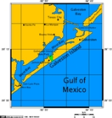
The island is about 27 miles (43 kilometers) long and no more than 3 miles (5 kilometers) wide at its widest point. The island is oriented generally northeast-southwest, with the
Gulf of MexicoThe Gulf of Mexico is a partially landlocked ocean basin largely surrounded by the North American continent and the island of Cuba. It is bounded on the northeast, north and northwest by the Gulf Coast of the United States, on the southwest and south by Mexico, and on the southeast by Cuba. In...
on the east and south,
West BayWest Bay, also referred to as West Galveston Bay, is a long inlet of Galveston Bay in Galveston and Brazoria counties that nearly runs the entire length west of Galveston Island.-History:...
on the west, and
Galveston BayGalveston Bay is a large estuary located along the upper coast of Texas in the United States. It is connected to the Gulf of Mexico and is surrounded by sub-tropic marshes and prairies on the mainland. The water in the Bay is a complex mixture of sea water and fresh water which supports a wide...
on the north. The island's main access point from the mainland is the
Interstate Highway 45Interstate 45 is an intrastate Interstate Highway located entirely within the U.S. state of Texas. It connects the cities of Dallas and Houston, continuing southeast from Houston to Galveston over the Galveston Causeway to the Gulf of Mexico...
causeway that crosses West Bay on the northeast side of the island. The far north end of the island is separated from the Bolivar Peninsula by Galveston Harbor, the entrance to Galveston Bay and the
Houston Ship ChannelThe Houston Ship Channel, located in Houston, Texas, is part of the Port of Houston—one of the United States's busiest seaports. The channel is the conduit for ocean-going vessels between the Houston-area shipyards and the Gulf of Mexico.-Overview:...
. Ferry service is available between Galveston Island and the Bolivar Peninsula. The southern end of the island is separated from the mainland by
San Luis PassSan Luis Pass is a strait of water at the south-western end of Galveston Island off the shores of the U.S. state of Texas. It connects the sheltered waters of West Bay to the open Gulf of Mexico.-Fishing:...
. The San Luis Pass-Vacek Toll Bridge connects the San Luis Pass Road on Galveston Island with the Bluewater Highway that leads south into the town of
Surfside BeachSurfside Beach is a city in Brazoria County, Texas, United States that is situated on the Gulf of Mexico just west of Galveston Island. The city is part of the Greater Houston area. The population was 763 at the 2000 census...
.
The people of the island (the non-tourists) distinguish each other in two ways: “BOI” (Born On the Island) and “IBC” (Islander By Choice). “BOI” is cited in print from at least 1956 and “IBC” is cited in print from 1975.
Education
All residents are zoned to
Ball High SchoolBall High School is a public secondary school in Galveston, Texas, United States. Ball, which covers grades 9 through 12, is a part of Galveston Independent School District....
.
Colleges and universities include:
- Galveston Community College (GCC)
- Texas A&M University at Galveston
Texas A&M University at Galveston is an ocean-oriented branch campus of Texas A&M University offering undergraduate degrees in marine biology, marine fisheries, marine engineering technology, marine sciences, marine transportation, maritime administration, maritime studies, maritime systems...
(TAMUG)
- University of Texas Medical Branch
The University of Texas Medical Branch is a component of the University of Texas System located in Galveston, Texas, United States, about 50 miles southeast of Downtown Houston...
(UTMB)
History
Originally,
AkokisaThe Akokisa were the indigenous tribe that lived on Galveston Bay and the lower Trinity and San Jacinto rivers in Texas, primarily in the present-day Greater Houston area...
and
KarankawaKarankawa were a group of Native American peoples, now extinct as a tribal group, who played a pivotal part in early Texas history....
Indians lived and camped there. Some believe the island is where
Álvar Núñez Cabeza de VacaÁlvar Núñez Cabeza de Vaca was a Spanish explorer of the New World, one of four survivors of the Narváez expedition...
and his party made a brief stop-over in November 1528, during his infamous odyssey.
Jao de la PortaJoão da Porta , along with his older brother Morin, was a Portuguese Jewish merchant important in the early settlement of the Texan coast....
, along with his brother Morin,
finance"Finance" is often defined simply as the management of money or “funds” management Modern finance, however, is a family of business activity that includes the origination, marketing, and management of cash and money surrogates through a variety of capital accounts, instruments, and markets created...
d the first settlement by
EuropeanThe ethnic groups in Europe are the various ethnic groups that reside in the nations of Europe. European ethnology is the field of anthropology focusing on Europe....
s on Galveston Island in 1816. Joa de la Porta was born in Portugal of Jewish parentage and later became a Jewish Texan
traderA merchant is a businessperson who trades in commodities that were produced by others, in order to earn a profit.Merchants can be one of two types:# A wholesale merchant operates in the chain between producer and retail merchant...
. The island colony came to be led by privateer
Jean LafitteJean Lafitte was a pirate and privateer in the Gulf of Mexico in the early 19th century. He and his elder brother, Pierre, spelled their last name Laffite, but English-language documents of the time used "Lafitte", and this is the commonly seen spelling in the United States, including for places...
, who named it
Campeche (Jao was named
supercargoSupercargo is a term in maritime law that refers to a person employed on board a vessel by the owner of cargo carried on the ship...
for the Karankawa Indian trade and later became a full-time trader). For a few years the island and the bay were a base for piracy and slave trading. After attacking an American ship, however, Lafitte was forced to leave in 1821 by the U.S. Navy.
With the advent of
Mexican independenceThe Mexican War of Independence was an armed conflict between the people of Mexico and the Spanish colonial authorities which started on 16 September 1810. The movement, which became known as the Mexican War of Independence, was led by Mexican-born Spaniards, Mestizos and Amerindians who sought...
, and the
Texas revolutionThe Texas Revolution or Texas War of Independence was an armed conflict between Mexico and settlers in the Texas portion of the Mexican state Coahuila y Tejas. The war lasted from October 2, 1835 to April 21, 1836...
soon after, Texas began to grow rapidly. The island quickly became Texas' primary port and a magnet for immigration. Following Texas' annexation by the United States, the island's population surpassed the population of
San AntonioSan Antonio is the seventh-largest city in the United States of America and the second-largest city within the state of Texas, with a population of 1.33 million. Located in the American Southwest and the south–central part of Texas, the city serves as the seat of Bexar County. In 2011,...
making it the state's major population center, a title it would hold until nearly the end of the 19th century. Galveston for a time was the largest cotton shipping port in the world and the second large port for immigration in the United States.
On September 8, 1900, the greatest natural disaster to ever strike the United States occurred at Galveston. In the early evening hours of September 8, the
Galveston hurricane of 1900The Hurricane of 1900 made landfall on the city of Galveston in the U.S. state of Texas, on September 8, 1900.It had estimated winds of at landfall, making it a Category 4 storm on the Saffir-Simpson Hurricane Scale...
came ashore, bringing with it a great
storm surgeA storm surge is an offshore rise of water associated with a low pressure weather system, typically tropical cyclones and strong extratropical cyclones. Storm surges are caused primarily by high winds pushing on the ocean's surface. The wind causes the water to pile up higher than the ordinary sea...
that inundated most of Galveston Island and the city of Galveston. As a result, much of the city was destroyed and at least 6,000 people were killed in a few hours' time.
Isaac M. Cline, the meteorologist in charge of the local Weather Bureau, lived on Galveston Island. Cline was aware of a storm in the Gulf based on previous reports from Florida. Although weather conditions were relatively calm on September 7, Cline observed the rough seas and the high waves that seemed to become more ominous by the hour. He sent a telegram to Washington, D.C., saying he thought a large part of the city was going to be underwater. He predicted a very heavy loss of life.
After the hurricane passed, a
seawallA seawall is a form of coastal defence constructed where the sea, and associated coastal processes, impact directly upon the landforms of the coast. The purpose of a seawall is to protect areas of human habitation, conservation and leisure activities from the action of tides and waves...
was
constructedThe Galveston Seawall is a seawall in Galveston, Texas, USA that was built after the Galveston Hurricane of 1900 for protection from future hurricanes. Construction began in September, 1902, and the initial segment was completed on July 29, 1904. From 1904 to 1963, the seawall was extended from ...
around the settled portion of the island. Some houses were raised, and others were built on stilts. Sand dredged from nearby waterways was pumped into the area within the seawall, and in time, the elevation of the eastern portion of the island was raised by as much as 17 feet (5.2 m).
See also
- Henry Cohen Community House
- History of the Jews in Galveston, Texas
Jews have inhabited the city of Galveston, Texas, for almost two centuries. The first known Jewish immigrant to the Galveston area was Jao de la Porta, who, along with his brother Morin, financed the first settlement by Europeans on Galveston Island in 1816. de la Porta was born in Portugal of...
External links
----