
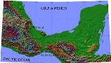
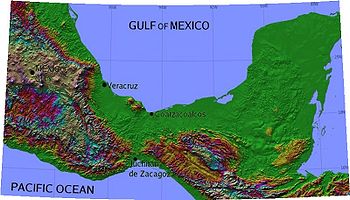
Isthmus of Tehuantepec
Encyclopedia
Isthmus
An isthmus is a narrow strip of land connecting two larger land areas usually with waterforms on either side.Canals are often built through isthmuses where they may be particularly advantageous to create a shortcut for marine transportation...
in Mexico
Mexico
The United Mexican States , commonly known as Mexico , is a federal constitutional republic in North America. It is bordered on the north by the United States; on the south and west by the Pacific Ocean; on the southeast by Guatemala, Belize, and the Caribbean Sea; and on the east by the Gulf of...
. It represents the shortest distance between the Gulf of Mexico
Gulf of Mexico
The Gulf of Mexico is a partially landlocked ocean basin largely surrounded by the North American continent and the island of Cuba. It is bounded on the northeast, north and northwest by the Gulf Coast of the United States, on the southwest and south by Mexico, and on the southeast by Cuba. In...
and the Pacific Ocean
Pacific Ocean
The Pacific Ocean is the largest of the Earth's oceanic divisions. It extends from the Arctic in the north to the Southern Ocean in the south, bounded by Asia and Australia in the west, and the Americas in the east.At 165.2 million square kilometres in area, this largest division of the World...
, and prior to the opening of the Panama Canal
Panama Canal
The Panama Canal is a ship canal in Panama that joins the Atlantic Ocean and the Pacific Ocean and is a key conduit for international maritime trade. Built from 1904 to 1914, the canal has seen annual traffic rise from about 1,000 ships early on to 14,702 vessels measuring a total of 309.6...
was a major shipping route known simply as the Tehuantepec Route. The name is taken from the town of Santo Domingo Tehuantepec
Tehuantepec
Tehuantepec is a city and municipality in the southeast of the Mexican state of Oaxaca. It is part of the Tehuantepec District in the west of the Istmo Region. The area was important in pre Hispanic period as part of a trade route that connected Central America with what is now the center of...
in the state of Oaxaca
Oaxaca
Oaxaca , , officially Estado Libre y Soberano de Oaxaca is one of the 31 states which, along with the Federal District, comprise the 32 federative entities of Mexico. It is divided into 571 municipalities; of which 418 are governed by the system of customs and traditions...
, which in turn comes from the Nahuatl tecuani-tepec ("jaguar hill
Jaguars in Mesoamerican culture
The representation of jaguars in Mesoamerican cultures has a long history, with iconographic examples dating back to at least the mid-Formative period of Mesoamerican chronology. The jaguar is an animal with a prominent association and appearance in the cultures and belief systems of pre-Columbian...
").
Geography
The isthmus includes the part of Mexico lying between the 94th94th meridian west
The meridian 94° west of Greenwich is a line of longitude that extends from the North Pole across the Arctic Ocean, North America, the Gulf of Mexico, Central America, the Pacific Ocean, the Southern Ocean, and Antarctica to the South Pole....
and 96th meridian
96th meridian west
The meridian 96° west of Greenwich is a line of longitude that extends from the North Pole across the Arctic Ocean, North America, the Gulf of Mexico, the Pacific Ocean, the Southern Ocean, and Antarctica to the South Pole....
s west longitude
Longitude
Longitude is a geographic coordinate that specifies the east-west position of a point on the Earth's surface. It is an angular measurement, usually expressed in degrees, minutes and seconds, and denoted by the Greek letter lambda ....
, or the southeastern parts of Veracruz and Oaxaca, including small areas of Chiapas and Tabasco. The states
States of Mexico
The United Mexican States is a federal republic formed by 32 federal entities .According to the Constitution of 1917, the states of the federation are free and sovereign. Each state has their own congress and constitution, while the Federal District has only limited autonomy with a local Congress...
of Tabasco
Tabasco
Tabasco officially Estado Libre y Soberano de Tabasco is one of the 31 states which, with the Federal District, comprise the 32 Federal Entities of Mexico. It is divided in 17 municipalities and its capital city is Villahermosa....
and Chiapas
Chiapas
Chiapas officially Estado Libre y Soberano de Chiapas is one of the 31 states that, with the Federal District, comprise the 32 Federal Entities of Mexico. It is divided in 118 municipalities and its capital city is Tuxtla Gutierrez. Other important cites in Chiapas include San Cristóbal de las...
are east of the isthmus
Isthmus
An isthmus is a narrow strip of land connecting two larger land areas usually with waterforms on either side.Canals are often built through isthmuses where they may be particularly advantageous to create a shortcut for marine transportation...
, with Veracruz
Veracruz
Veracruz, formally Veracruz de Ignacio de la Llave officially Estado Libre y Soberano de Veracruz de Ignacio de la Llave , is one of the 31 states that, along with the Federal District, comprise the 32 federative entities of Mexico. It is divided in 212 municipalities and its capital city is...
and Oaxaca
Oaxaca
Oaxaca , , officially Estado Libre y Soberano de Oaxaca is one of the 31 states which, along with the Federal District, comprise the 32 federative entities of Mexico. It is divided into 571 municipalities; of which 418 are governed by the system of customs and traditions...
on the west.
At its narrowest point, the isthmus is 200 km (124.3 mi) across from gulf to gulf, or 192 km (119.3 mi) to the head of Laguna Superior on the Pacific coast. The Sierra Madre
Sierra Madre del Sur
The Sierra Madre del Sur is a mountain range in southern Mexico, extending from southern Michoacán east through Guerrero, to the Istmo de Tehuantepec in eastern Oaxaca.-Geography:...
breaks down at this point into a broad, plateau
Plateau
In geology and earth science, a plateau , also called a high plain or tableland, is an area of highland, usually consisting of relatively flat terrain. A highly eroded plateau is called a dissected plateau...
-like ridge, whose elevation, at the highest point reached by the Ferrocarril Transistmico railway at Chivela Pass
Chivela Pass
The Chivela Pass is a narrow mountain pass in the Sierra Madre Mountains that funnels cooler drier air from the North American continent, through southern Mexico, into the Pacific...
, is 224 m (735 ft). The northern side of the isthmus is swamp
Swamp
A swamp is a wetland with some flooding of large areas of land by shallow bodies of water. A swamp generally has a large number of hammocks, or dry-land protrusions, covered by aquatic vegetation, or vegetation that tolerates periodical inundation. The two main types of swamp are "true" or swamp...
y and densely covered with jungle
Jungle
A Jungle is an area of land in the tropics overgrown with dense vegetation.The word jungle originates from the Sanskrit word jangala which referred to uncultivated land. Although the Sanskrit word refers to "dry land", it has been suggested that an Anglo-Indian interpretation led to its...
, which has been a greater obstacle to railway construction than the grades in crossing the sierra.
The Selva Zoque
Selva Zoque
The Selva Zoque , which includes the Chimalapas rain forest, is an area of great ecological importance in Mexico. Most of the forest lies in the state of Oaxaca but parts are in Chiapas and Veracruz....
in the eastern-central region of the isthmus is an area of great ecological importance, the largest remaining area of tropical rainforest in Mexico with the majority of the terrestrial biodiversity in Mexico.
The Sierra Madre de Oaxaca
Sierra Madre de Oaxaca
The Sierra Madre de Oaxaca is a mountain range in southern Mexico. It begins at Pico de Orizaba and extends in a southeasterly direction for 300 km until reaching the Isthmus of Tehuantepec...
mountains flatten out to form Chivela Pass
Chivela Pass
The Chivela Pass is a narrow mountain pass in the Sierra Madre Mountains that funnels cooler drier air from the North American continent, through southern Mexico, into the Pacific...
before the Sierra Madre de Chiapas
Sierra Madre de Chiapas
Sierra Madre is a mountain range which runs northwest-southeast from the state of Chiapas in Mexico across Guatemala and into El Salvador and Honduras. Most of the volcanoes of Guatemala are a part of this range.A narrow coastal plain lies south the range, between the Sierra Madre and the Pacific...
mountains resume to the south, so geographically the isthmus divides North America from Central America. However, the southern edge of the North American tectonic plate
North American Plate
The North American Plate is a tectonic plate covering most of North America, Greenland, Cuba, Bahamas, and parts of Siberia, Japan and Iceland. It extends eastward to the Mid-Atlantic Ridge and westward to the Chersky Range in eastern Siberia. The plate includes both continental and oceanic crust...
lies across the Motagua Fault
Motagua Fault
The Motagua Fault is a major, active left lateral-moving transform fault which cuts across Guatemala. It forms part of the tectonic boundary between the North American Plate and the Caribbean Plate...
in Guatemala
Guatemala
Guatemala is a country in Central America bordered by Mexico to the north and west, the Pacific Ocean to the southwest, Belize to the northeast, the Caribbean to the east, and Honduras and El Salvador to the southeast...
, so geologically, the division between North America and Central America (on the Caribbean Plate
Caribbean Plate
The Caribbean Plate is a mostly oceanic tectonic plate underlying Central America and the Caribbean Sea off the north coast of South America....
) is much farther south than the isthmus of Tehuantepec.
Climate
The whole region is hot and malariaMalaria
Malaria is a mosquito-borne infectious disease of humans and other animals caused by eukaryotic protists of the genus Plasmodium. The disease results from the multiplication of Plasmodium parasites within red blood cells, causing symptoms that typically include fever and headache, in severe cases...
l, except for the open elevations, where the winds from the Pacific Ocean render the weather comparatively cool and healthy. The annual rainfall on the Atlantic
Atlantic Ocean
The Atlantic Ocean is the second-largest of the world's oceanic divisions. With a total area of about , it covers approximately 20% of the Earth's surface and about 26% of its water surface area...
or northern slope is 3,960 mm (156 in) and the maximum temperature about 35 degrees Celsius (95 degrees Fahrenheit) in the shade. The Pacific slope has a light rainfall and drier climate
Climate
Climate encompasses the statistics of temperature, humidity, atmospheric pressure, wind, rainfall, atmospheric particle count and other meteorological elemental measurements in a given region over long periods...
.
The narrowness of the isthmus, and the gap in the Sierra Madre, allow the trade wind
Trade wind
The trade winds are the prevailing pattern of easterly surface winds found in the tropics, within the lower portion of the Earth's atmosphere, in the lower section of the troposphere near the Earth's equator...
s from the Gulf of Mexico to blow through to the Pacific. Normally, these winds are not particularly strong, but periodically, a surge of denser air originating from the North American continent will send strong winds through the Chivela Pass
Chivela Pass
The Chivela Pass is a narrow mountain pass in the Sierra Madre Mountains that funnels cooler drier air from the North American continent, through southern Mexico, into the Pacific...
and out over the Gulf of Tehuantepec
Gulf of Tehuantepec
Gulf of Tehuantepec is a large body of water on the Pacific coast of the Isthmus of Tehuantepec, southeastern Mexico, at . Most of the hurricanes that form in the Eastern Pacific organize in or near this body of water...
on the Pacific coast. This wind is known as the Tehuano
Tehuano wind
The Tehuano wind is a north to northeasterly wind which periodically blows across the Isthmus of Tehuantepec in southern Mexico. The wind is stronger than the trade winds which normally blow here. It is notable for causing a pronounced increase in upwelling of cooler, nutrient-rich waters in the...
.
People and culture
The population is composed almost wholly of indigenous Zapotec peoples. The women are the traders in Tehuantepec and do little menial work. Known as "Tehuanas," these women are known throughout Mexico for their colorful dresses, assertive personalities, and relatively equal relations with men, leading some to characterize them as "matriarchal."Cuisine
The cuisine of the region is based upon historically eaten foods and ingredients. Dishes may range from simple to elaborate, however most dishes incorporate maizeMaize
Maize known in many English-speaking countries as corn or mielie/mealie, is a grain domesticated by indigenous peoples in Mesoamerica in prehistoric times. The leafy stalk produces ears which contain seeds called kernels. Though technically a grain, maize kernels are used in cooking as a vegetable...
and moles
Mole (sauce)
Mole is the generic name for a number of sauces used in Mexican cuisine, as well as for dishes based on these sauces...
. Common items include tamale
Tamale
A tamale — or more correctly tamal — is a traditional Latin American dish made of masa , which is steamed or boiled in a leaf wrapper. The wrapping is discarded before eating...
s made with iguana
Iguana
Iguana is a herbivorous genus of lizard native to tropical areas of Central America and the Caribbean. The genus was first described in 1768 by Austrian naturalist Josephus Nicolaus Laurenti in his book Specimen Medicum, Exhibens Synopsin Reptilium Emendatam cum Experimentis circa Venena...
, chicken, beef or armadillo
Armadillo
Armadillos are New World placental mammals, known for having a leathery armor shell. Dasypodidae is the only surviving family in the order Cingulata, part of the superorder Xenarthra along with the anteaters and sloths. The word armadillo is Spanish for "little armored one"...
, Guetabingui (fried balls of rice and shrimp), Garnachas topped with dried Queso Oaxaca and Pozol
Pozol
Pozol is a name for both the fermented corn dough and the drink made from it, which has its origins in Pre-Columbian Mexico. To the drink, other ingredients besides corn dough and water, such as cocoa, may be added...
, a maize-based drink .
Tehuantepec Route
Since the days of Hernán CortésHernán Cortés
Hernán Cortés de Monroy y Pizarro, 1st Marquis of the Valley of Oaxaca was a Spanish Conquistador who led an expedition that caused the fall of the Aztec Empire and brought large portions of mainland Mexico under the rule of the King of Castile in the early 16th century...
, the Tehuantepec isthmus has been considered a favorable route, first for an interoceanic canal
Canal
Canals are man-made channels for water. There are two types of canal:#Waterways: navigable transportation canals used for carrying ships and boats shipping goods and conveying people, further subdivided into two kinds:...
, and since the 19th century for an interoceanic railway. Its proximity to the axis of international trade gives it some advantage over the Panama
Panama
Panama , officially the Republic of Panama , is the southernmost country of Central America. Situated on the isthmus connecting North and South America, it is bordered by Costa Rica to the northwest, Colombia to the southeast, the Caribbean Sea to the north and the Pacific Ocean to the south. The...
route; the Isthmus of Panama, however, is significantly narrower, making for a shorter traversal, even if the canal is farther from trade routes. See also: Panama Canal
Panama Canal
The Panama Canal is a ship canal in Panama that joins the Atlantic Ocean and the Pacific Ocean and is a key conduit for international maritime trade. Built from 1904 to 1914, the canal has seen annual traffic rise from about 1,000 ships early on to 14,702 vessels measuring a total of 309.6...
, Nicaragua Canal
Nicaragua Canal
The Inter-Oceanic Nicaragua Canal was a proposed waterway through Nicaragua to connect the Caribbean Sea and Atlantic Ocean with the Pacific Ocean...
.
The 1853 Gadsden Purchase
Gadsden Purchase
The Gadsden Purchase is a region of present-day southern Arizona and southwestern New Mexico that was purchased by the United States in a treaty signed by James Gadsden, the American ambassador to Mexico at the time, on December 30, 1853. It was then ratified, with changes, by the U.S...
treaty included a provision allowing the U.S. to transport mail and trade goods across the Isthmus of Tehuantepec via a plank road
Plank road
A plank road or puncheon is a dirt path or road covered with a series of planks, similar to the wooden sidewalks one would see in a Western movie. Plank roads were very popular in Ontario, the U.S. Northeast and U.S. Midwest in the first half of the 19th century...
and railroad. The 1859 McLane-Ocampo Treaty
McLane-Ocampo Treaty
The McLane-Ocampo Treaty, formally the Treaty of Transit and Commerce, was an agreement between the United States and Mexico, signed in the port of Veracruz in Mexico on December 14, 1859, which would have sold the perpetual right of transit to the Isthmus of Tehuantepec to the U.S...
, which Benito Juárez
Benito Juárez
Benito Juárez born Benito Pablo Juárez García, was a Mexican lawyer and politician of Zapotec origin from Oaxaca who served five terms as president of Mexico: 1858–1861 as interim, 1861–1865, 1865–1867, 1867–1871 and 1871–1872...
signed but was never ratified by the United States Congress, would have given the U.S. extensive transit rights along the same route.
When the great cost of a canal across the isthmus compelled engineer
Engineer
An engineer is a professional practitioner of engineering, concerned with applying scientific knowledge, mathematics and ingenuity to develop solutions for technical problems. Engineers design materials, structures, machines and systems while considering the limitations imposed by practicality,...
s and capitalist
Capitalism
Capitalism is an economic system that became dominant in the Western world following the demise of feudalism. There is no consensus on the precise definition nor on how the term should be used as a historical category...
s to give it up as impracticable, James B. Eads proposed to construct a quadruple track ship-railway, and the scheme received serious attention for some time. Then came projects for an ordinary railway, and several concessions were granted by the Mexican government
Government
Government refers to the legislators, administrators, and arbitrators in the administrative bureaucracy who control a state at a given time, and to the system of government by which they are organized...
for this purpose from 1857 to 1882. In the latter year the Mexican government resolved to undertake the enterprise on its own account, and entered into contracts with a prominent Mexican contractor
General contractor
A general contractor is responsible for the day-to-day oversight of a construction site, management of vendors and trades, and communication of information to involved parties throughout the course of a building project.-Description:...
for the work. In 1888 this contract was rescinded, after 108 km (67.1 mi) of road had been completed. The next contract was fruitless because of the death of the contractor, and the third failed to complete the work within the sum specified . This was in 1893, and 60 km (37.3 mi) remained to be built. A fourth contract resulted in the completion of the 130-mile line from coast to coast in 1894, when it was found that the terminal ports were deficient in facilities and the road too light for heavy traffic. The government then entered into a contract with the London firm of contractors of S. Pearson & Son, Ltd.
Pearson PLC
Pearson plc is a global media and education company headquartered in London, United Kingdom. It is both the largest education company and the largest book publisher in the world, with consumer imprints including Penguin, Dorling Kindersley and Ladybird...
, who had constructed the drainage works of the valley of Mexico and the new port
Port
A port is a location on a coast or shore containing one or more harbors where ships can dock and transfer people or cargo to or from land....
works of Veracruz
Veracruz, Veracruz
Veracruz, officially known as Heroica Veracruz, is a major port city and municipality on the Gulf of Mexico in the Mexican state of Veracruz. The city is located in the central part of the state. It is located along Federal Highway 140 from the state capital Xalapa, and is the state's most...
, to rebuild the line and construct terminal ports at Coatzacoalcos
Coatzacoalcos
Coatzacoalcos is a major port city in the southern part of the Mexican state of Veracruz, on the Coatzacoalcos River. Coatzacoalcos comes from an indigenous word meaning "Site of the Snake" or "Where the snake hides"...
on the Gulf coast
Gulf of Mexico
The Gulf of Mexico is a partially landlocked ocean basin largely surrounded by the North American continent and the island of Cuba. It is bounded on the northeast, north and northwest by the Gulf Coast of the United States, on the southwest and south by Mexico, and on the southeast by Cuba. In...
, and at Salina Cruz
Salina Cruz
Salina Cruz is a major seaport on the Pacific coast of the Mexican state of Oaxaca. It is the state's third-largest city and is municipal seat of the municipality of the same name.It is part of the Tehuantepec District in the west of the Istmo Region....
on the Pacific side. The work was done for account of the Mexican government. Work began on 10 December 1899, and was finished to a point where its formal opening for traffic
Traffic
Traffic on roads may consist of pedestrians, ridden or herded animals, vehicles, streetcars and other conveyances, either singly or together, while using the public way for purposes of travel...
was possible in January 1907.
The railway is 308 km (191.4 mi) long, with a branch of 29 km (18 mi) between Juile and San Juan Evangelista
San Juan Evangelista
San Juan Evangelista is a municipality located in the plains of the Sotavento zone in the central zone of the State of Veracruz, about 260 km from state capital Xalapa. It has a surface of 968.94 km2...
. The minimum depth at low water in both ports is 10 m (33 ft), and an extensive system of quays and railway tracks at both terminals affords ample facilities for the expeditious handling of heavy cargo
Cargo
Cargo is goods or produce transported, generally for commercial gain, by ship, aircraft, train, van or truck. In modern times, containers are used in most intermodal long-haul cargo transport.-Marine:...
es. The general offices and repair shops of the original Tehuantepec Railway were originally located at Rincón Antonio, at the entrance to the Chivela Pass
Chivela Pass
The Chivela Pass is a narrow mountain pass in the Sierra Madre Mountains that funnels cooler drier air from the North American continent, through southern Mexico, into the Pacific...
. At Santa Lucrecia, 175 km (108.7 mi) from Salina Cruz, connection was made with the Veracruz & Pacific Railway, 343 km (213.1 mi) to Córdoba, Veracruz
Córdoba, Veracruz
Córdoba, officially known as Heroica Córdoba, is a city and the seat of the municipality of the same name in the Mexican state of Veracruz. It was founded in 1618....
, and 500 km (310.7 mi) to Mexico City
Mexico City
Mexico City is the Federal District , capital of Mexico and seat of the federal powers of the Mexican Union. It is a federal entity within Mexico which is not part of any one of the 31 Mexican states but belongs to the federation as a whole...
. Those connecting lines are now owned and operated by Ferrosur, a company that also operates along the Ferroistmo owned Tuehantepec line.
See also
- American-Hawaiian Steamship CompanyAmerican-Hawaiian Steamship CompanyThe American-Hawaiian Steamship Company was founded in 1899 to carry cargos of sugar from Hawaii to the United States and manufactured goods on return trips...
- Ferrocarril de Veracruz al IstmoFerrocarril de Veracruz al IstmoThe Ferrocarril de Veracruz al Istmo was one of the primary pre-nationalization railways of Mexico. Incorporated in West Virginia in 1898 as the Vera Cruz and Pacific Railroad , it built a line from Córdoba to Jesús Carranza on the Tehuantepec National Railway, with a branch from Veracruz to...
- Istmo de Tehuantepec, OaxacaIstmo de Tehuantepec, OaxacaIstmo de Tehuantepec is the largest region in the state of Oaxaca, Mexico. It covers the southern part of the Isthmus of Tehuantepec, the shortest route between the Gulf of Mexico and the Pacific Ocean before the Panama Canal was opened....
- Isthmus of PanamaIsthmus of PanamaThe Isthmus of Panama, also historically known as the Isthmus of Darien, is the narrow strip of land that lies between the Caribbean Sea and the Pacific Ocean, linking North and South America. It contains the country of Panama and the Panama Canal...
is the site of the Panama CanalPanama CanalThe Panama Canal is a ship canal in Panama that joins the Atlantic Ocean and the Pacific Ocean and is a key conduit for international maritime trade. Built from 1904 to 1914, the canal has seen annual traffic rise from about 1,000 ships early on to 14,702 vessels measuring a total of 309.6... - Mexican Federal Highway 185Mexican Federal Highway 185Mexican Federal Highway 185 is a Federal Highway of Mexico....
- Nicaragua CanalNicaragua CanalThe Inter-Oceanic Nicaragua Canal was a proposed waterway through Nicaragua to connect the Caribbean Sea and Atlantic Ocean with the Pacific Ocean...
External links
- The Tehuantepec Ship-Railway
- The Mexican Railways, with information on the current owners (concessions) of Mexican railways.