

Subtropical ridge
Encyclopedia
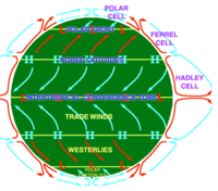
High pressure area
A high-pressure area is a region where the atmospheric pressure at the surface of the planet is greater than its surrounding environment. Winds within high-pressure areas flow outward due to the higher density air near their center and friction with land...
situated around the latitudes of 30°N
30th parallel north
The 30th parallel north is a circle of latitude that is 30 degrees north of the Earth's equatorial plane. It stands one-third of the way between the equator and the North Pole and crosses Africa, Asia, the Pacific Ocean, North America and the Atlantic Ocean....
in the Northern Hemisphere
Northern Hemisphere
The Northern Hemisphere is the half of a planet that is north of its equator—the word hemisphere literally means “half sphere”. It is also that half of the celestial sphere north of the celestial equator...
and 30°S
30th parallel south
The 30th parallel south is a circle of latitude that is 30 degrees south of the Earth's equatorial plane. It crosses the Atlantic Ocean, Africa, the Indian Ocean, Australasia, the Pacific Ocean and South America....
in the Southern Hemisphere
Southern Hemisphere
The Southern Hemisphere is the part of Earth that lies south of the equator. The word hemisphere literally means 'half ball' or "half sphere"...
. It is characterized by mostly calm winds, which acts to reduce air quality under its axis by causing fog
Fog
Fog is a collection of water droplets or ice crystals suspended in the air at or near the Earth's surface. While fog is a type of stratus cloud, the term "fog" is typically distinguished from the more generic term "cloud" in that fog is low-lying, and the moisture in the fog is often generated...
overnight, and haze
Haze
Haze is traditionally an atmospheric phenomenon where dust, smoke and other dry particles obscure the clarity of the sky. The World Meteorological Organization manual of codes includes a classification of horizontal obscuration into categories of fog, ice fog, steam fog, mist, haze, smoke, volcanic...
during daylight hours caused by the stable atmosphere found near its location. Air flows out from its center toward the upper and lower latitudes of each hemisphere, creating both the trade wind
Trade wind
The trade winds are the prevailing pattern of easterly surface winds found in the tropics, within the lower portion of the Earth's atmosphere, in the lower section of the troposphere near the Earth's equator...
s and the westerlies
Westerlies
The Westerlies, anti-trades, or Prevailing Westerlies, are the prevailing winds in the middle latitudes between 30 and 60 degrees latitude, blowing from the high pressure area in the horse latitudes towards the poles. These prevailing winds blow from the west to the east, and steer extratropical...
. It moves poleward during the summer, reaching its most northern latitude in early fall, before moving equatorward during the cold season. The ENSO
Enso
Ensō is a Japanese word meaning "circle" and a concept strongly associated with Zen. Ensō is one of the most common subjects of Japanese calligraphy even though it is a symbol and not a character. It symbolizes the Absolute enlightenment, strength, elegance, the Universe, and the void; it can...
climate
Climate
Climate encompasses the statistics of temperature, humidity, atmospheric pressure, wind, rainfall, atmospheric particle count and other meteorological elemental measurements in a given region over long periods...
cycle can displace the subtropical ridge, with La Niñas allowing for a more northerly axis for the ridge, while El Niños show flatter, more southerly ridges. The change of the ridge position during ENSO cycles changes tracks of tropical cyclone
Tropical cyclone
A tropical cyclone is a storm system characterized by a large low-pressure center and numerous thunderstorms that produce strong winds and heavy rain. Tropical cyclones strengthen when water evaporated from the ocean is released as the saturated air rises, resulting in condensation of water vapor...
s that form around their southern and western peripheries. As the subtropical ridge varies in position and strength, it can enhance or depress monsoon
Monsoon
Monsoon is traditionally defined as a seasonal reversing wind accompanied by corresponding changes in precipitation, but is now used to describe seasonal changes in atmospheric circulation and precipitation associated with the asymmetric heating of land and sea...
regimes around their southern periphery.
Formation
Heating of the earth near the equator leads to large amounts of upward motion and convection along the monsoon troughMonsoon trough
The monsoon trough is that portion of the Intertropical Convergence Zone which extends into or through a monsoon circulation, as depicted by a line on a weather map showing the locations of minimum sea level pressure, and as such, is a convergence zone between the wind patterns of the southern and...
or Intertropical convergence zone
Intertropical Convergence Zone
The Intertropical Convergence Zone , known by sailors as The Doldrums, is the area encircling the earth near the equator where winds originating in the northern and southern hemispheres come together....
. The divergence over the near-equatorial trough leads to air rising and moving away from the equator aloft. As it moves towards the Mid-Latitudes, the air cools and sinks, which leads to subsidence near the 30th parallel of both hemispheres. This circulation is known as the Hadley cell
Hadley cell
The Hadley cell, named after George Hadley, is a circulation pattern that dominates the tropical atmosphere, with rising motion near the equator, poleward flow 10–15 kilometers above the surface, descending motion in the subtropics, and equatorward flow near the surface...
and leads to the formation of the subtropical ridge. Many of the world's deserts are caused by these climatological high-pressure areas.
Migration
Monsoon trough
The monsoon trough is that portion of the Intertropical Convergence Zone which extends into or through a monsoon circulation, as depicted by a line on a weather map showing the locations of minimum sea level pressure, and as such, is a convergence zone between the wind patterns of the southern and...
or Intertropical Convergence Zone
Intertropical Convergence Zone
The Intertropical Convergence Zone , known by sailors as The Doldrums, is the area encircling the earth near the equator where winds originating in the northern and southern hemispheres come together....
.
Most tropical cyclone
Tropical cyclone
A tropical cyclone is a storm system characterized by a large low-pressure center and numerous thunderstorms that produce strong winds and heavy rain. Tropical cyclones strengthen when water evaporated from the ocean is released as the saturated air rises, resulting in condensation of water vapor...
s form on the side of the subtropical ridge closer to the equator
Equator
An equator is the intersection of a sphere's surface with the plane perpendicular to the sphere's axis of rotation and containing the sphere's center of mass....
, then move poleward past the ridge axis before recurving into the main belt of the Westerlies. When the subtropical ridge shifts due to ENSO, so will the preferred tropical cyclone tracks. Areas west of Japan
Japan
Japan is an island nation in East Asia. Located in the Pacific Ocean, it lies to the east of the Sea of Japan, China, North Korea, South Korea and Russia, stretching from the Sea of Okhotsk in the north to the East China Sea and Taiwan in the south...
and Korea
Korea
Korea ) is an East Asian geographic region that is currently divided into two separate sovereign states — North Korea and South Korea. Located on the Korean Peninsula, Korea is bordered by the People's Republic of China to the northwest, Russia to the northeast, and is separated from Japan to the...
tend to experience much fewer September-November tropical cyclone impacts during El Niño and neutral years, while mainland China
China
Chinese civilization may refer to:* China for more general discussion of the country.* Chinese culture* Greater China, the transnational community of ethnic Chinese.* History of China* Sinosphere, the area historically affected by Chinese culture...
experiences much greater landfall frequency during La Niña
La Niña
La Niña is a coupled ocean-atmosphere phenomenon that is the counterpart of El Niño as part of the broader El Niño-Southern Oscillation climate pattern. During a period of La Niña, the sea surface temperature across the equatorial Eastern Central Pacific Ocean will be lower than normal by 3–5 °C...
years. During El Niño years, the break in the subtropical ridge tends to lie near 130°E
130th meridian east
The meridian 130° east of Greenwich is a line of longitude that extends from the North Pole across the Arctic Ocean, Asia, Australia, the Indian Ocean, the Southern Ocean, and Antarctica to the South Pole....
, which would favor the Japanese archipelago, while in La Niña years the formation of tropical cyclones, along with the subtropical ridge position, shift west, which increases the threat to China. In the Atlantic basin, the subtropical ridge position tends to lie about 5 degrees farther south during El Niño years, which leads to a more southerly recurvature for tropical cyclones during those years.
When the Atlantic Multidecadal Oscillation
Atlantic Multidecadal Oscillation
The Atlantic multidecadal oscillation is a mode of variability occurring in the North Atlantic Ocean and which has its principal expression in the sea surface temperature field...
's mode is favorable to tropical cyclone development
Tropical cyclogenesis
Tropical cyclogenesis is the term that describes the development and strengthening of a tropical cyclone in the atmosphere. The mechanisms through which tropical cyclogenesis occurs are distinctly different from those through which mid-latitude cyclogenesis occurs...
(1995-present), it amplifies the subtropical ridge across the central and eastern Atlantic.
Importance to global monsoon regimes

Monsoon
Monsoon is traditionally defined as a seasonal reversing wind accompanied by corresponding changes in precipitation, but is now used to describe seasonal changes in atmospheric circulation and precipitation associated with the asymmetric heating of land and sea...
season for Asia
Asia
Asia is the world's largest and most populous continent, located primarily in the eastern and northern hemispheres. It covers 8.7% of the Earth's total surface area and with approximately 3.879 billion people, it hosts 60% of the world's current human population...
. The subtropical ridge position is linked to how far northward monsoon moisture and thunderstorm
Thunderstorm
A thunderstorm, also known as an electrical storm, a lightning storm, thundershower or simply a storm is a form of weather characterized by the presence of lightning and its acoustic effect on the Earth's atmosphere known as thunder. The meteorologically assigned cloud type associated with the...
s extend into the United States
United States
The United States of America is a federal constitutional republic comprising fifty states and a federal district...
. The subtropical ridge across North America
North America
North America is a continent wholly within the Northern Hemisphere and almost wholly within the Western Hemisphere. It is also considered a northern subcontinent of the Americas...
typically migrates far enough northward to begin monsoon conditions across the Desert Southwest from July to September.Arizona State University (2009). Basics of the Arizona Monsoon & Desert Meteorology. Retrieved on 2007-02-11. When the subtropical ridge is farther north than normal towards the Four Corners, monsoon thunderstorms can spread northward into Arizona
Arizona
Arizona ; is a state located in the southwestern region of the United States. It is also part of the western United States and the mountain west. The capital and largest city is Phoenix...
. When suppressed to the south, the atmosphere dries out across the Desert Southwest, causing a break in the monsoon regime.
Role in haze and fog formation
When surface winds become light, the subsidence produced directly under the subtropical ridge can lead to a build up of particulates in urban areas under the ridge, leading to widespread hazeHaze
Haze is traditionally an atmospheric phenomenon where dust, smoke and other dry particles obscure the clarity of the sky. The World Meteorological Organization manual of codes includes a classification of horizontal obscuration into categories of fog, ice fog, steam fog, mist, haze, smoke, volcanic...
. If the low level relative humidity
Relative humidity
Relative humidity is a term used to describe the amount of water vapor in a mixture of air and water vapor. It is defined as the partial pressure of water vapor in the air-water mixture, given as a percentage of the saturated vapor pressure under those conditions...
rises towards 100 percent overnight, fog
Fog
Fog is a collection of water droplets or ice crystals suspended in the air at or near the Earth's surface. While fog is a type of stratus cloud, the term "fog" is typically distinguished from the more generic term "cloud" in that fog is low-lying, and the moisture in the fog is often generated...
can form.