

Matagorda Island
Encyclopedia
Barrier island
Barrier islands, a coastal landform and a type of barrier system, are relatively narrow strips of sand that parallel the mainland coast. They usually occur in chains, consisting of anything from a few islands to more than a dozen...
on the Texas
Texas
Texas is the second largest U.S. state by both area and population, and the largest state by area in the contiguous United States.The name, based on the Caddo word "Tejas" meaning "friends" or "allies", was applied by the Spanish to the Caddo themselves and to the region of their settlement in...
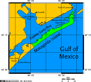
Gulf coast, about seven miles south of Port O'Connor
Port O'Connor, Texas
Port O'Connor is an unincorporated village in Calhoun County, Texas, United States, on the coastline between Galveston and Corpus Christi. The ZIP Code Tabulation Area including Port O'Connor had a population of 1,078 at the 2000 census...
, in the southernmost part of Calhoun County
Calhoun County, Texas
Calhoun County is a county located in the U.S. state of Texas. In 2000, the population was 20,647. Its county seat is Port Lavaca. It is a part of the Victoria Metropolitan Statistical Area...
. The island is oriented generally northeast-southwest, with the Gulf of Mexico
Gulf of Mexico
The Gulf of Mexico is a partially landlocked ocean basin largely surrounded by the North American continent and the island of Cuba. It is bounded on the northeast, north and northwest by the Gulf Coast of the United States, on the southwest and south by Mexico, and on the southeast by Cuba. In...
on the east and south, and Espiritu Santo Bay
Espiritu Santo Bay
Espiritu Santo Bay is a northeastern extension of San Antonio Bay in Calhoun County, Texas. It is separated from Matagorda Bay by a line of barrier islands that run south from Port O'Connor to Matagorda Island.-History:...
on the west and north. It is separated from San José Island to the south by Cedar Bayou
Cedar Bayou
Cedar Bayou is a salt water channel on the Texas coast that separates San Jose Island from Matagorda Island. The pass serves as a water exchange between the Gulf of Mexico and the San Antonio, Matagorda and Aransas Bay systems.-History:...
, and is separated from the Matagorda Peninsula
Matagorda Peninsula
The Matagorda Peninsula is a narrow spit of land on the southeastern coast of Texas in the United States.The peninsula is in Matagorda County, Texas. It lies between Matagorda Bay, an estuary, and the Gulf of Mexico, and water is exchanged between the two through five main tidal...
to the north by Pass Cavallo
Pass Cavallo (Texas)
Pass Cavallo, alternately known as Cavallo Pass, is one of five natural water inlets which separate the Gulf of Mexico and Matagorda Bay, in the U.S. state of Texas. René-Robert Cavelier, Sieur de La Salle came ashore in Texas at this point. Matagorda Island Lighthouse was originally built on...
. It has no permanent residents and is accessible only by private boat and passenger ferry. It has a land area of 157.25 km² (60.7 sq mi).
Matagorda Island State Park occupies 7325 acres (29.64 km²) on the northeastern end of the island. The remainder of the island is devoted to wildlife refuge
Wildlife refuge
A wildlife refuge, also called a wildlife sanctuary, may be a naturally occurring sanctuary, such as an island, that provides protection for species from hunting, predation or competition, or it may refer to a protected area, a geographic territory within which wildlife is protected...
s managed by the Texas Parks and Wildlife Department
Texas Parks and Wildlife Department
The Texas Parks & Wildlife Department is a Texas state agency that oversees and protects wildlife and their habitats. In addition, the agency is responsible for managing the state's parks and historical areas...
and the United States Fish and Wildlife Service
United States Fish and Wildlife Service
The United States Fish and Wildlife Service is a federal government agency within the United States Department of the Interior dedicated to the management of fish, wildlife, and natural habitats...
and is known as Matagorda Island National Wildlife Refuge and State Natural Area.
The land that is now Matagorda Island State park was acquired in 1940 by condemnation from the Hawes, Hill, and Little families (but not the Wynne-Murchison interests) for use as a temporary training facility for the WWII era.
Matagorda Island State Park was featured as a "survival location" by the main characters in the book, 'Day by Day Armageddon' by J.L. Bourne.