
.gif)
Tropical Storm Grace (2003)
Encyclopedia
Tropical Storm Grace was a weak tropical storm
that struck Texas
in the 2003 Atlantic hurricane season
. The eleventh tropical depression and the seventh tropical storm of the season, Grace was also the weakest storm of the season. On August 30 the storm developed from a long-track tropical wave
in the western Gulf of Mexico
. Grace remained disorganized throughout its lifetime due to an upper level low to its west. The weak storm moved northwestward and made landfall on southeastern Texas. Grace quickly weakened over land, and dissipated on September 2 as it merged into a cold front
.
In Texas, the storm dropped heavy rainfall, causing minor flash flooding damage. The cold front, combined with the remnants of the storm, dropped moderate to heavy rainfall from Texas through the Mid-Atlantic. The worst of the flooding occurred in Indianapolis
, where record rainfall affected over 700 homes. Despite the rainfall, damage was minimal along its path.
accompanied with a low pressure system moved off the coast of Africa
on August 19. It moved quickly westward and organized, developing banding features and cirrus outflow near the blossoming convection. The wave nearly developed into a tropical cyclone on August 21, though its fast forward motion dislocated the low level circulation from the deep convection. The wave entered an area of dry air in the central Atlantic Ocean
, and by late on August 22 most of the convection dissipated from the system. On August 24, convection increased as the wave passed through the Lesser Antilles
, though strong southwesterly upper level wind shear
prevented further development. The tropical wave moved through the Caribbean Sea
, and developed deep convection due to more favorable conditions over the Gulf of Honduras
on August 28. The wave crossed the Yucatán Peninsula
, and developed a surface low pressure area on the 29th in the Gulf of Mexico
. Convection continued to organize, and the tropical wave developed into Tropical Depression Eleven on August 30 while located 335 miles (540 km) east-southeast of Corpus Christi, Texas
.
The depression moved to the northwest, and intensified into Tropical Storm Grace six hours after forming. Despite the increase in winds the center of circulation remained very broad, with Reconnaissance Aircraft
having difficulty pinpointing the center. In addition, an upper level low located over Brownsville, Texas
produced shear over the western portion of the system, which limited outflow to the east side. Forecasters predicted the upper level low to weaken, allowing for the possibility of Grace to intensify to a 65 mph (100 km/h) tropical storm over warm waters. However, the upper level low remained in place and continued to produce shear across the system. A new center of circulation reformed 115 miles (185 km) north of the original center, and made landfall near San Luis Pass on the southwestern portion of Galveston Island
on August 31 as a minimal tropical storm. Grace quickly weakened to a tropical depression over land, and after turning northeastward into Oklahoma
the depression was absorbed by a cold front
.
from High Island
to Corpus Christi, Texas
. Local National Weather Service
offices requested a voluntary evacuation for western Galveston Island
including Jamaica Beach
, the Bolivar Peninsula, and coastal areas of Brazoria
and Matagorda counties, though few residents heeded the warnings. Local emergency management officials predicted tides of up to 5 feet (1.5 m) above normal with coastal flooding.
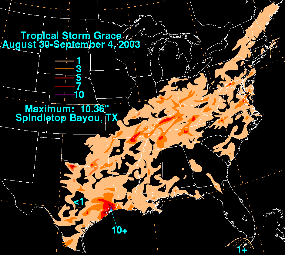 Grace produced moderate amounts of rainfall along its path, peaking in southern Texas
. The storm later merged with a cold front, which later dropped heavy rainfall in the Mid-West United States
. In addition to its impact on the United States, the outer rainbands of Grace caused light rainfall in Yucatán
and northern Tamaulipas
.
and North Jetty, Texas
. Wind gusts peaked at 53 mph (85 km/h) with sustained winds of 40 mph (64 km/h) at Sea Rim State Park
. Locations closer to where the storm made landfall reported below tropical storm force winds, with the exception of Galveston
which recorded a 40 mph (64 km/h) wind gust. Rainfall was moderate to heavy across eastern Texas
, peaking at 10.36 inches (263 mm) in Spindletop Bayou
. The outer bands of Grace spawned a waterspout
just south of the western tip of Galveston Island
, prompting the issuance of a tornado warning
. The waterspout dissipated before moving onshore. The storm also caused light beach erosion, though little occurred beyond the erosion caused by Hurricane Claudette
one month prior. Near the coast, high tides from the storm flooded piers, bulkheads, and low-lying areas. Further inland, heavy rainfall lead to flash flooding, covering roads and entering a few houses. Overall, damage was minor, and totaled to $113,000 (2003 USD, $132,400 2008 USD).
In Oklahoma
, moisture from the storm, combined with a slow-moving cold front, produced heavy rainfall across the state, peaking at 8.98 inches (228 mm) in Courtney. Due to below normal precipitation by as much as 5 to 10 inches (127 to 255 mm), flooding was localized and overall minimal. Near Medford
, the rainfall lead to 2 feet (0.6 m) deep flooding on U.S. Highway 81, forcing its closure. The rainfall was welcome in the state, and lessened the rainfall deficit.
Tropical Storm Grace, combined with the slow-moving cold front, produced light to moderate rainfall totals across the southern United States, including isolated locations in Louisiana
and Mississippi
reporting over 3 inches (76 mm) and over 5 inches (127 mm) in northeastern Arkansas
.
, the cold front combined with moisture from the remnants of Grace brought temporary relief to a severe drought by producing light to moderate rainfall of up to 5 inches (127 mm) in the southeastern portion of the state. In Poplar Bluff
, the rainfall caused severe flooding, resulting in rescues for people in trapped vehicles. The moisture produced over 5 inches (127 mm) in northern Kentucky
, as well.
Moisture from the remnants of Grace dropped heavy rainfall across central Indiana
, including a record one day total of 7 inches (178 mm) in Indianapolis
, while other locations received over 9 inches (228 mm). Residents prepared sand bags to prevent overflowing rivers and creeks, though rising waters entered streets and over 700 homes. The rapid rainfall in Indianapolis backed up the sewage system, sending hundreds of millions of gallons of sewage into the streets. Following the deluge in the state, the governor declared a state of emergency for the state. Eight local American Red Cross
chapters arrived to provide meals and aid to the affected people.
The remnants of Grace dropped moderate to heavy rainfall eastward through the Mid-Atlantic States
and New England
. Locations in extreme western Maryland
and southeastern Virginia
received over 5 inches (127 mm) of rain. In Maryland, Hagerstown
recorded 3.94 inches (100 mm), resulting in flash flooding. In Washington County
, the system produced 1.09 inches (27.8 mm) of rain, a new daily record. Damage in Maryland, if any, was unknown.
Tropical cyclone
A tropical cyclone is a storm system characterized by a large low-pressure center and numerous thunderstorms that produce strong winds and heavy rain. Tropical cyclones strengthen when water evaporated from the ocean is released as the saturated air rises, resulting in condensation of water vapor...
that struck Texas
Texas
Texas is the second largest U.S. state by both area and population, and the largest state by area in the contiguous United States.The name, based on the Caddo word "Tejas" meaning "friends" or "allies", was applied by the Spanish to the Caddo themselves and to the region of their settlement in...
in the 2003 Atlantic hurricane season
2003 Atlantic hurricane season
The 2003 Atlantic hurricane season was an active Atlantic hurricane season with tropical activity before and after the official bounds of the season – the first such occurrence in 50 years. The season produced 21 tropical cyclones, of which 16 developed into named storms; seven...
. The eleventh tropical depression and the seventh tropical storm of the season, Grace was also the weakest storm of the season. On August 30 the storm developed from a long-track tropical wave
Tropical wave
Tropical waves, easterly waves, or tropical easterly waves, also known as African easterly waves in the Atlantic region, are a type of atmospheric trough, an elongated area of relatively low air pressure, oriented north to south, which move from east to west across the tropics causing areas of...
in the western Gulf of Mexico
Gulf of Mexico
The Gulf of Mexico is a partially landlocked ocean basin largely surrounded by the North American continent and the island of Cuba. It is bounded on the northeast, north and northwest by the Gulf Coast of the United States, on the southwest and south by Mexico, and on the southeast by Cuba. In...
. Grace remained disorganized throughout its lifetime due to an upper level low to its west. The weak storm moved northwestward and made landfall on southeastern Texas. Grace quickly weakened over land, and dissipated on September 2 as it merged into a cold front
Cold front
A cold front is defined as the leading edge of a cooler mass of air, replacing a warmer mass of air.-Development of cold front:The cooler and denser air wedges under the less-dense warmer air, lifting it...
.
In Texas, the storm dropped heavy rainfall, causing minor flash flooding damage. The cold front, combined with the remnants of the storm, dropped moderate to heavy rainfall from Texas through the Mid-Atlantic. The worst of the flooding occurred in Indianapolis
Indianapolis
Indianapolis is the capital of the U.S. state of Indiana, and the county seat of Marion County, Indiana. As of the 2010 United States Census, the city's population is 839,489. It is by far Indiana's largest city and, as of the 2010 U.S...
, where record rainfall affected over 700 homes. Despite the rainfall, damage was minimal along its path.
Meteorological history
A strong tropical waveTropical wave
Tropical waves, easterly waves, or tropical easterly waves, also known as African easterly waves in the Atlantic region, are a type of atmospheric trough, an elongated area of relatively low air pressure, oriented north to south, which move from east to west across the tropics causing areas of...
accompanied with a low pressure system moved off the coast of Africa
Africa
Africa is the world's second largest and second most populous continent, after Asia. At about 30.2 million km² including adjacent islands, it covers 6% of the Earth's total surface area and 20.4% of the total land area...
on August 19. It moved quickly westward and organized, developing banding features and cirrus outflow near the blossoming convection. The wave nearly developed into a tropical cyclone on August 21, though its fast forward motion dislocated the low level circulation from the deep convection. The wave entered an area of dry air in the central Atlantic Ocean
Atlantic Ocean
The Atlantic Ocean is the second-largest of the world's oceanic divisions. With a total area of about , it covers approximately 20% of the Earth's surface and about 26% of its water surface area...
, and by late on August 22 most of the convection dissipated from the system. On August 24, convection increased as the wave passed through the Lesser Antilles
Lesser Antilles
The Lesser Antilles are a long, partly volcanic island arc in the Western Hemisphere. Most of its islands form the eastern boundary of the Caribbean Sea with the Atlantic Ocean, with the remainder located in the southern Caribbean just north of South America...
, though strong southwesterly upper level wind shear
Wind shear
Wind shear, sometimes referred to as windshear or wind gradient, is a difference in wind speed and direction over a relatively short distance in the atmosphere...
prevented further development. The tropical wave moved through the Caribbean Sea
Caribbean Sea
The Caribbean Sea is a sea of the Atlantic Ocean located in the tropics of the Western hemisphere. It is bounded by Mexico and Central America to the west and southwest, to the north by the Greater Antilles, and to the east by the Lesser Antilles....
, and developed deep convection due to more favorable conditions over the Gulf of Honduras
Gulf of Honduras
The Gulf or Bay of Honduras is a large inlet of the Caribbean Sea, indenting the coasts of Belize, Guatemala, and Honduras. From north to south, it runs for approximately 200 km from Dangriga, Belize, to La Ceiba, Honduras....
on August 28. The wave crossed the Yucatán Peninsula
Yucatán Peninsula
The Yucatán Peninsula, in southeastern Mexico, separates the Caribbean Sea from the Gulf of Mexico, with the northern coastline on the Yucatán Channel...
, and developed a surface low pressure area on the 29th in the Gulf of Mexico
Gulf of Mexico
The Gulf of Mexico is a partially landlocked ocean basin largely surrounded by the North American continent and the island of Cuba. It is bounded on the northeast, north and northwest by the Gulf Coast of the United States, on the southwest and south by Mexico, and on the southeast by Cuba. In...
. Convection continued to organize, and the tropical wave developed into Tropical Depression Eleven on August 30 while located 335 miles (540 km) east-southeast of Corpus Christi, Texas
Corpus Christi, Texas
Corpus Christi is a coastal city in the South Texas region of the U.S. state of Texas. The county seat of Nueces County, it also extends into Aransas, Kleberg, and San Patricio counties. The MSA population in 2008 was 416,376. The population was 305,215 at the 2010 census making it the...
.
The depression moved to the northwest, and intensified into Tropical Storm Grace six hours after forming. Despite the increase in winds the center of circulation remained very broad, with Reconnaissance Aircraft
Reconnaissance aircraft
A reconnaissance aircraft is a manned military aircraft designed, or adapted, to carry out aerial reconnaissance.-History:The majority of World War I aircraft were reconnaissance designs...
having difficulty pinpointing the center. In addition, an upper level low located over Brownsville, Texas
Brownsville, Texas
Brownsville is a city in the southernmost tip of the state of Texas, in the United States. It is located on the northern bank of the Rio Grande, directly north and across the border from Matamoros, Tamaulipas, Mexico. Brownsville is the 16th largest city in the state of Texas with a population of...
produced shear over the western portion of the system, which limited outflow to the east side. Forecasters predicted the upper level low to weaken, allowing for the possibility of Grace to intensify to a 65 mph (100 km/h) tropical storm over warm waters. However, the upper level low remained in place and continued to produce shear across the system. A new center of circulation reformed 115 miles (185 km) north of the original center, and made landfall near San Luis Pass on the southwestern portion of Galveston Island
Galveston Island
Galveston Island is a barrier island on the Texas Gulf coast in the United States, about 50 miles southeast of Houston. The entire island, with the exception of Jamaica Beach, is within the city limits of the City of Galveston....
on August 31 as a minimal tropical storm. Grace quickly weakened to a tropical depression over land, and after turning northeastward into Oklahoma
Oklahoma
Oklahoma is a state located in the South Central region of the United States of America. With an estimated 3,751,351 residents as of the 2010 census and a land area of 68,667 square miles , Oklahoma is the 28th most populous and 20th-largest state...
the depression was absorbed by a cold front
Cold front
A cold front is defined as the leading edge of a cooler mass of air, replacing a warmer mass of air.-Development of cold front:The cooler and denser air wedges under the less-dense warmer air, lifting it...
.
Preparations
Three hours after forming, officials issued Tropical Storm WarningsTropical cyclone warnings and watches
Warnings and watches are two levels of alert issued by national weather forecasting bodies to coastal areas threatened by the imminent approach of a tropical cyclone of tropical storm or hurricane intensity. They are notices to the local population and civil authorities to make appropriate...
from High Island
High Island, Texas
High Island is an unincorporated area located in the Bolivar Peninsula census-designated place, Galveston County, Texas, United States. The community is located in the extreme eastern part of the county on Bolivar Peninsula, less than one mile from Chambers County and less than two miles from...
to Corpus Christi, Texas
Corpus Christi, Texas
Corpus Christi is a coastal city in the South Texas region of the U.S. state of Texas. The county seat of Nueces County, it also extends into Aransas, Kleberg, and San Patricio counties. The MSA population in 2008 was 416,376. The population was 305,215 at the 2010 census making it the...
. Local National Weather Service
National Weather Service
The National Weather Service , once known as the Weather Bureau, is one of the six scientific agencies that make up the National Oceanic and Atmospheric Administration of the United States government...
offices requested a voluntary evacuation for western Galveston Island
Galveston Island
Galveston Island is a barrier island on the Texas Gulf coast in the United States, about 50 miles southeast of Houston. The entire island, with the exception of Jamaica Beach, is within the city limits of the City of Galveston....
including Jamaica Beach
Jamaica Beach, Texas
Jamaica Beach is a city in Galveston County, Texas, United States. As of the 2000 census, the city population was 1,075.-History:Prior to its development, Jamaica Beach was a Karankawa burial ground. Johnny Goyen and Earl Galceran of the Jamaica Corporation developed Jamaica Beach as a 2,000-lot...
, the Bolivar Peninsula, and coastal areas of Brazoria
Brazoria County, Texas
Brazoria County[p] is a county in the U.S. state of Texas, located on the Gulf Coast within the Houston–Sugar Land–Baytown metropolitan area. Regionally, parts of the county are within the extreme southern-most fringe of the regions locally known as Southeast Texas. Brazoria County is among a...
and Matagorda counties, though few residents heeded the warnings. Local emergency management officials predicted tides of up to 5 feet (1.5 m) above normal with coastal flooding.
Impact
Texas
Texas is the second largest U.S. state by both area and population, and the largest state by area in the contiguous United States.The name, based on the Caddo word "Tejas" meaning "friends" or "allies", was applied by the Spanish to the Caddo themselves and to the region of their settlement in...
. The storm later merged with a cold front, which later dropped heavy rainfall in the Mid-West United States
United States
The United States of America is a federal constitutional republic comprising fifty states and a federal district...
. In addition to its impact on the United States, the outer rainbands of Grace caused light rainfall in Yucatán
Yucatán
Yucatán officially Estado Libre y Soberano de Yucatán is one of the 31 states which, with the Federal District, comprise the 32 Federal Entities of Mexico. It is divided in 106 municipalities and its capital city is Mérida....
and northern Tamaulipas
Tamaulipas
Tamaulipas officially Estado Libre y Soberano de Tamaulipas is one of the 31 states which, with the Federal District, comprise the 32 Federal Entities of Mexico. It is divided in 43 municipalities and its capital city is Ciudad Victoria. The capital city was named after Guadalupe Victoria, the...
.
South-Central United States
Upon making landfall, Tropical Storm Grace produced a light storm surge of 3.5 feet (1 m) in MatagordaMatagorda Island
Matagorda Island, Spanish for "thick brush," is a 38 mile long barrier island on the Texas Gulf coast, about seven miles south of Port O'Connor, in the southernmost part of Calhoun County. The island is oriented generally northeast-southwest, with the Gulf of Mexico on the east and south, and...
and North Jetty, Texas
Texas
Texas is the second largest U.S. state by both area and population, and the largest state by area in the contiguous United States.The name, based on the Caddo word "Tejas" meaning "friends" or "allies", was applied by the Spanish to the Caddo themselves and to the region of their settlement in...
. Wind gusts peaked at 53 mph (85 km/h) with sustained winds of 40 mph (64 km/h) at Sea Rim State Park
Sea Rim State Park
Sea Rim State Park is a state park in southeast Texas.The park is located on the Gulf of Mexico in southern Jefferson County, south of Port Arthur and just west of Sabine Pass. The park was closed for several years due to extensive damage from Hurricanes Rita and Ike . The park has recently...
. Locations closer to where the storm made landfall reported below tropical storm force winds, with the exception of Galveston
Galveston, Texas
Galveston is a coastal city located on Galveston Island in the U.S. state of Texas. , the city had a total population of 47,743 within an area of...
which recorded a 40 mph (64 km/h) wind gust. Rainfall was moderate to heavy across eastern Texas
Texas
Texas is the second largest U.S. state by both area and population, and the largest state by area in the contiguous United States.The name, based on the Caddo word "Tejas" meaning "friends" or "allies", was applied by the Spanish to the Caddo themselves and to the region of their settlement in...
, peaking at 10.36 inches (263 mm) in Spindletop Bayou
Spindletop
Spindletop is a salt dome oil field located in the southern portion of Beaumont, Texas in the United States. The Spindletop dome was derived from the Louann Salt evaporite layer of the Jurassic geologic period. On January 10, 1901, a well at Spindletop struck oil . The new oil field soon produced...
. The outer bands of Grace spawned a waterspout
Waterspout
A waterspout is an intense columnar vortex that occurs over a body of water and is connected to a cumuliform cloud. In the common form, it is a non-supercell tornado over water. While it is often weaker than most of its land counterparts, stronger versions spawned by mesocyclones do occur...
just south of the western tip of Galveston Island
Galveston Island
Galveston Island is a barrier island on the Texas Gulf coast in the United States, about 50 miles southeast of Houston. The entire island, with the exception of Jamaica Beach, is within the city limits of the City of Galveston....
, prompting the issuance of a tornado warning
Tornado warning
A tornado warning is an alert issued by government weather services to warn that severe thunderstorms with tornadoes may be imminent. It can be issued after a tornado or funnel cloud has been spotted by eye, or more commonly if there are radar indications of tornado formation...
. The waterspout dissipated before moving onshore. The storm also caused light beach erosion, though little occurred beyond the erosion caused by Hurricane Claudette
Hurricane Claudette (2003)
Hurricane Claudette was the third tropical storm and first hurricane of the 2003 Atlantic hurricane season. A fairly long-lived July Atlantic hurricane, Claudette began as a tropical wave in the eastern Caribbean. It moved quickly westward, brushing past the Yucatán Peninsula before moving...
one month prior. Near the coast, high tides from the storm flooded piers, bulkheads, and low-lying areas. Further inland, heavy rainfall lead to flash flooding, covering roads and entering a few houses. Overall, damage was minor, and totaled to $113,000 (2003 USD, $132,400 2008 USD).
In Oklahoma
Oklahoma
Oklahoma is a state located in the South Central region of the United States of America. With an estimated 3,751,351 residents as of the 2010 census and a land area of 68,667 square miles , Oklahoma is the 28th most populous and 20th-largest state...
, moisture from the storm, combined with a slow-moving cold front, produced heavy rainfall across the state, peaking at 8.98 inches (228 mm) in Courtney. Due to below normal precipitation by as much as 5 to 10 inches (127 to 255 mm), flooding was localized and overall minimal. Near Medford
Medford, Oklahoma
Medford is a city in and the county seat of Grant County, Oklahoma, United States. The population was 1,172 at the 2000 census.-History:Medford was founded by Hobart Johnstone Whitley, a land developer, banker, farmer and Rock Island Railroad executive....
, the rainfall lead to 2 feet (0.6 m) deep flooding on U.S. Highway 81, forcing its closure. The rainfall was welcome in the state, and lessened the rainfall deficit.
Tropical Storm Grace, combined with the slow-moving cold front, produced light to moderate rainfall totals across the southern United States, including isolated locations in Louisiana
Louisiana
Louisiana is a state located in the southern region of the United States of America. Its capital is Baton Rouge and largest city is New Orleans. Louisiana is the only state in the U.S. with political subdivisions termed parishes, which are local governments equivalent to counties...
and Mississippi
Mississippi
Mississippi is a U.S. state located in the Southern United States. Jackson is the state capital and largest city. The name of the state derives from the Mississippi River, which flows along its western boundary, whose name comes from the Ojibwe word misi-ziibi...
reporting over 3 inches (76 mm) and over 5 inches (127 mm) in northeastern Arkansas
Arkansas
Arkansas is a state located in the southern region of the United States. Its name is an Algonquian name of the Quapaw Indians. Arkansas shares borders with six states , and its eastern border is largely defined by the Mississippi River...
.
Ohio Valley and Eastern United States
In MissouriMissouri
Missouri is a US state located in the Midwestern United States, bordered by Iowa, Illinois, Kentucky, Tennessee, Arkansas, Oklahoma, Kansas and Nebraska. With a 2010 population of 5,988,927, Missouri is the 18th most populous state in the nation and the fifth most populous in the Midwest. It...
, the cold front combined with moisture from the remnants of Grace brought temporary relief to a severe drought by producing light to moderate rainfall of up to 5 inches (127 mm) in the southeastern portion of the state. In Poplar Bluff
Poplar Bluff, Missouri
Poplar Bluff is a city in Butler County located in Southeast Missouri in the United States. It is the county seat of Butler County and is known as "The Gateway to the Ozarks" among other names. As of the 2000 U.S...
, the rainfall caused severe flooding, resulting in rescues for people in trapped vehicles. The moisture produced over 5 inches (127 mm) in northern Kentucky
Kentucky
The Commonwealth of Kentucky is a state located in the East Central United States of America. As classified by the United States Census Bureau, Kentucky is a Southern state, more specifically in the East South Central region. Kentucky is one of four U.S. states constituted as a commonwealth...
, as well.
Moisture from the remnants of Grace dropped heavy rainfall across central Indiana
Indiana
Indiana is a US state, admitted to the United States as the 19th on December 11, 1816. It is located in the Midwestern United States and Great Lakes Region. With 6,483,802 residents, the state is ranked 15th in population and 16th in population density. Indiana is ranked 38th in land area and is...
, including a record one day total of 7 inches (178 mm) in Indianapolis
Indianapolis
Indianapolis is the capital of the U.S. state of Indiana, and the county seat of Marion County, Indiana. As of the 2010 United States Census, the city's population is 839,489. It is by far Indiana's largest city and, as of the 2010 U.S...
, while other locations received over 9 inches (228 mm). Residents prepared sand bags to prevent overflowing rivers and creeks, though rising waters entered streets and over 700 homes. The rapid rainfall in Indianapolis backed up the sewage system, sending hundreds of millions of gallons of sewage into the streets. Following the deluge in the state, the governor declared a state of emergency for the state. Eight local American Red Cross
American Red Cross
The American Red Cross , also known as the American National Red Cross, is a volunteer-led, humanitarian organization that provides emergency assistance, disaster relief and education inside the United States. It is the designated U.S...
chapters arrived to provide meals and aid to the affected people.
The remnants of Grace dropped moderate to heavy rainfall eastward through the Mid-Atlantic States
Mid-Atlantic States
The Mid-Atlantic states, also called middle Atlantic states or simply the mid Atlantic, form a region of the United States generally located between New England and the South...
and New England
New England
New England is a region in the northeastern corner of the United States consisting of the six states of Maine, New Hampshire, Vermont, Massachusetts, Rhode Island, and Connecticut...
. Locations in extreme western Maryland
Maryland
Maryland is a U.S. state located in the Mid Atlantic region of the United States, bordering Virginia, West Virginia, and the District of Columbia to its south and west; Pennsylvania to its north; and Delaware to its east...
and southeastern Virginia
Virginia
The Commonwealth of Virginia , is a U.S. state on the Atlantic Coast of the Southern United States. Virginia is nicknamed the "Old Dominion" and sometimes the "Mother of Presidents" after the eight U.S. presidents born there...
received over 5 inches (127 mm) of rain. In Maryland, Hagerstown
Hagerstown, Maryland
Hagerstown is a city in northwestern Maryland, United States. It is the county seat of Washington County, and, by many definitions, the largest city in a region known as Western Maryland. The population of Hagerstown city proper at the 2010 census was 39,662, and the population of the...
recorded 3.94 inches (100 mm), resulting in flash flooding. In Washington County
Washington County, Maryland
Washington County is a county located in the western part of the U.S. state of Maryland, bordering southern Pennsylvania to the north, northern Virginia to the south, and the Eastern Panhandle of West Virginia to the south and west. As of the 2010 Census, its population is 147,430...
, the system produced 1.09 inches (27.8 mm) of rain, a new daily record. Damage in Maryland, if any, was unknown.
See also
- Tropical Storm Grace (disambiguation)
- Timeline of the 2003 Atlantic hurricane seasonTimeline of the 2003 Atlantic hurricane seasonThe 2003 Atlantic hurricane season was an active Atlantic hurricane season with tropical activity before and after the official bounds of the season – the first such occurrence in 50 years. The season officially began on June 1, 2003 and ended on November 30...
- List of storms in the 2003 Atlantic hurricane season
- List of Florida hurricanes (2000–present)
- List of North Carolina hurricanes (1980–present)