
Subregion
Encyclopedia
A subregion is a conceptual unit which derives from a larger region
or continent
and is usually based on location. Cardinal directions, such as south or southern, are commonly used to define a subregion.
 The Statistics Division of the United Nations
(UN) is in charge of the collection, processing, and dissemination of statistical information for the UN. In 1999, it developed a system of macro-geographical (continental) regions, subregions, and other selected economic groups to report advances towards achieving numerous millennial development goals
worldwide. This geoscheme was devised for statistical purposes and is used for carrying out statistical analysis. The division's first publication was the book World's Women 2000: Trends and Statistics in 2000.
According to the UN, the assignment of countries or areas to specific groupings is for statistical convenience and does not imply any assumption regarding political or other affiliation of countries or territories.
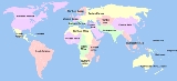
Africa
North America
South America
Asia
Europe
Oceania
Region
Region is most commonly found as a term used in terrestrial and astrophysics sciences also an area, notably among the different sub-disciplines of geography, studied by regional geographers. Regions consist of subregions that contain clusters of like areas that are distinctive by their uniformity...
or continent
Continent
A continent is one of several very large landmasses on Earth. They are generally identified by convention rather than any strict criteria, with seven regions commonly regarded as continents—they are : Asia, Africa, North America, South America, Antarctica, Europe, and Australia.Plate tectonics is...
and is usually based on location. Cardinal directions, such as south or southern, are commonly used to define a subregion.
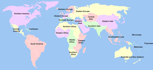
United Nations subregions
- Main article: United Nations geoscheme
United Nations
The United Nations is an international organization whose stated aims are facilitating cooperation in international law, international security, economic development, social progress, human rights, and achievement of world peace...
(UN) is in charge of the collection, processing, and dissemination of statistical information for the UN. In 1999, it developed a system of macro-geographical (continental) regions, subregions, and other selected economic groups to report advances towards achieving numerous millennial development goals
Millennium Development Goals
The Millennium Development Goals are eight international development goals that all 193 United Nations member states and at least 23 international organizations have agreed to achieve by the year 2015...
worldwide. This geoscheme was devised for statistical purposes and is used for carrying out statistical analysis. The division's first publication was the book World's Women 2000: Trends and Statistics in 2000.
According to the UN, the assignment of countries or areas to specific groupings is for statistical convenience and does not imply any assumption regarding political or other affiliation of countries or territories.
Subregions by continent
The following is a non-exhaustive list of subregions, arranged alphabetically by region (i.e., by continent); in the UN geoscheme, higher-level, macro-geographical regions are arranged to the extent possible according to continents. AfricaAfricaAfrica is the world's second largest and second most populous continent, after Asia. At about 30.2 million km² including adjacent islands, it covers 6% of the Earth's total surface area and 20.4% of the total land area...
- by UN subregion:
- Northern AfricaNorth AfricaNorth Africa or Northern Africa is the northernmost region of the African continent, linked by the Sahara to Sub-Saharan Africa. Geopolitically, the United Nations definition of Northern Africa includes eight countries or territories; Algeria, Egypt, Libya, Morocco, South Sudan, Sudan, Tunisia, and...
- Western AfricaWest AfricaWest Africa or Western Africa is the westernmost region of the African continent. Geopolitically, the UN definition of Western Africa includes the following 16 countries and an area of approximately 5 million square km:-Flags of West Africa:...
- Middle AfricaCentral AfricaCentral Africa is a core region of the African continent which includes Burundi, the Central African Republic, Chad, the Democratic Republic of the Congo, and Rwanda....
- Eastern AfricaEast AfricaEast Africa or Eastern Africa is the easterly region of the African continent, variably defined by geography or geopolitics. In the UN scheme of geographic regions, 19 territories constitute Eastern Africa:...
- Southern AfricaSouthern AfricaSouthern Africa is the southernmost region of the African continent, variably defined by geography or geopolitics. Within the region are numerous territories, including the Republic of South Africa ; nowadays, the simpler term South Africa is generally reserved for the country in English.-UN...
- Northern Africa
- by geography:
- North AfricaNorth AfricaNorth Africa or Northern Africa is the northernmost region of the African continent, linked by the Sahara to Sub-Saharan Africa. Geopolitically, the United Nations definition of Northern Africa includes eight countries or territories; Algeria, Egypt, Libya, Morocco, South Sudan, Sudan, Tunisia, and...
- MaghrebMaghrebThe Maghreb is the region of Northwest Africa, west of Egypt. It includes five countries: Morocco, Algeria, Tunisia, Libya, and Mauritania and the disputed territory of Western Sahara...
- SahelSahelThe Sahel is the ecoclimatic and biogeographic zone of transition between the Sahara desert in the North and the Sudanian Savannas in the south.It stretches across the North African continent between the Atlantic Ocean and the Red Sea....
- Maghreb
- Sub-Saharan AfricaSub-Saharan AfricaSub-Saharan Africa as a geographical term refers to the area of the African continent which lies south of the Sahara. A political definition of Sub-Saharan Africa, instead, covers all African countries which are fully or partially located south of the Sahara...
- West AfricaWest AfricaWest Africa or Western Africa is the westernmost region of the African continent. Geopolitically, the UN definition of Western Africa includes the following 16 countries and an area of approximately 5 million square km:-Flags of West Africa:...
- East AfricaEast AfricaEast Africa or Eastern Africa is the easterly region of the African continent, variably defined by geography or geopolitics. In the UN scheme of geographic regions, 19 territories constitute Eastern Africa:...
- Horn of AfricaHorn of AfricaThe Horn of Africa is a peninsula in East Africa that juts hundreds of kilometers into the Arabian Sea and lies along the southern side of the Gulf of Aden. It is the easternmost projection of the African continent...
- Central AfricaCentral AfricaCentral Africa is a core region of the African continent which includes Burundi, the Central African Republic, Chad, the Democratic Republic of the Congo, and Rwanda....
- CongoCongo BasinThe Congo Basin is the sedimentary basin that is the drainage of the Congo River of west equatorial Africa. The basin begins in the highlands of the East African Rift system with input from the Chambeshi River, the Uele and Ubangi Rivers in the upper reaches and the Lualaba River draining wetlands...
- Southern AfricaSouthern AfricaSouthern Africa is the southernmost region of the African continent, variably defined by geography or geopolitics. Within the region are numerous territories, including the Republic of South Africa ; nowadays, the simpler term South Africa is generally reserved for the country in English.-UN...
- Sudan (region)Sudan (region)The Sudan is the name given to a geographic region to the south of the Sahara, stretching from Western to Eastern Africa. The name derives from the Arabic bilâd as-sûdân or "land of the Blacks"...
- West Africa
- North Africa
- by geology:
-
- Kaapvaal cratonKaapvaal cratonThe Kaapvaal craton , along with the Pilbara craton of Western Australia, are the only remaining areas of pristine 3.6-2.5 Ga crust on Earth...
- Zimbabwe cratonZimbabwe cratonThe Zimbabwe craton is an area in Southern Africa of ancient continental crust and an example of Early Archaean lithology dating back to 3.5 billion years ago in the southern African nation of Zimbabwe. Late Archean metamorphism joined the Southern Marginal Zone of the Kaapvaal craton to the...
- Kaapvaal craton
-
North AmericaNorth AmericaNorth America is a continent wholly within the Northern Hemisphere and almost wholly within the Western Hemisphere. It is also considered a northern subcontinent of the Americas...
- by UN subregion:
- Northern AmericaNorthern AmericaNorthern America is the northernmost region of the Americas, and is part of the North American continent. It lies directly north of the region of Middle America; the land border between the two regions coincides with the border between the United States and Mexico...
- South AmericaSouth AmericaSouth America is a continent situated in the Western Hemisphere, mostly in the Southern Hemisphere, with a relatively small portion in the Northern Hemisphere. The continent is also considered a subcontinent of the Americas. It is bordered on the west by the Pacific Ocean and on the north and east...
- Central AmericaCentral AmericaCentral America is the central geographic region of the Americas. It is the southernmost, isthmian portion of the North American continent, which connects with South America on the southeast. When considered part of the unified continental model, it is considered a subcontinent...
- CaribbeanCaribbeanThe Caribbean is a crescent-shaped group of islands more than 2,000 miles long separating the Gulf of Mexico and the Caribbean Sea, to the west and south, from the Atlantic Ocean, to the east and north...
- Northern America
- by geography:
- Canadian Arctic
- Great BasinGreat BasinThe Great Basin is the largest area of contiguous endorheic watersheds in North America and is noted for its arid conditions and Basin and Range topography that varies from the North American low point at Badwater Basin to the highest point of the contiguous United States, less than away at the...
- Great PlainsGreat PlainsThe Great Plains are a broad expanse of flat land, much of it covered in prairie, steppe and grassland, which lies west of the Mississippi River and east of the Rocky Mountains in the United States and Canada. This area covers parts of the U.S...
- Great LakesGreat LakesThe Great Lakes are a collection of freshwater lakes located in northeastern North America, on the Canada – United States border. Consisting of Lakes Superior, Michigan, Huron, Erie, and Ontario, they form the largest group of freshwater lakes on Earth by total surface, coming in second by volume...
- The Greater AntillesGreater AntillesThe Greater Antilles are one of three island groups in the Caribbean. Comprising Cuba, Jamaica, Hispaniola , and Puerto Rico, the Greater Antilles constitute almost 90% of the land mass of the entire West Indies.-Greater Antilles in context :The islands of the Caribbean Sea, collectively known as...
- The Lesser AntillesLesser AntillesThe Lesser Antilles are a long, partly volcanic island arc in the Western Hemisphere. Most of its islands form the eastern boundary of the Caribbean Sea with the Atlantic Ocean, with the remainder located in the southern Caribbean just north of South America...
- by geology:
- Canadian ShieldCanadian ShieldThe Canadian Shield, also called the Laurentian Plateau, or Bouclier Canadien , is a vast geological shield covered by a thin layer of soil that forms the nucleus of the North American or Laurentia craton. It is an area mostly composed of igneous rock which relates to its long volcanic history...
- North American craton
- Slave cratonSlave cratonThe Slave craton is a Canadian geological formation located in the Northwest Territories and Nunavut. This craton is approximately in size and forms part of the Canadian Shield. It is dominated by ca. 2.73-2.63 Ga greenstones and turbidite sequences and ca. 2.72-2.58 Ga plutonic rock, with large...
- Superior cratonSuperior cratonThe Superior craton forms the core of the Canadian Shield at the heart of the North American continent. It extends from Quebec in the east to eastern Manitoba in the west...
- Wyoming cratonWyoming cratonThe Wyoming craton is a craton located in the west-central United States and western Canada – more specifically, in Montana, Wyoming, southern Alberta, southern Saskatchewan, and parts of northern Utah...
- Canadian Shield
- by economics:
- North American Free Trade Agreement (NAFTA)North American Free Trade AgreementThe North American Free Trade Agreement or NAFTA is an agreement signed by the governments of Canada, Mexico, and the United States, creating a trilateral trade bloc in North America. The agreement came into force on January 1, 1994. It superseded the Canada – United States Free Trade Agreement...
- Caribbean Community (CARICOM)Caribbean CommunityThe Caribbean Community is an organisation of 15 Caribbean nations and dependencies. CARICOM's main purposes are to promote economic integration and cooperation among its members, to ensure that the benefits of integration are equitably shared, and to coordinate foreign policy...
- PETROCARIBEPetrocaribePetrocaribe S. A. is a Caribbean oil alliance with Venezuela to purchase oil on conditions of preferential payment. The alliance was launched in June 2005. The payment system allows for a few nations to buy oil on market value but only a certain amount is needed up front; the remainder can be paid...
- Central America Free Trade Agreement (CAFTA)
- North American Free Trade Agreement (NAFTA)
South AmericaSouth AmericaSouth America is a continent situated in the Western Hemisphere, mostly in the Southern Hemisphere, with a relatively small portion in the Northern Hemisphere. The continent is also considered a subcontinent of the Americas. It is bordered on the west by the Pacific Ocean and on the north and east...
- by geography:
- AltiplanoAltiplanoThe Altiplano , in west-central South America, where the Andes are at their widest, is the most extensive area of high plateau on Earth outside of Tibet...
- Amazon BasinAmazon BasinThe Amazon Basin is the part of South America drained by the Amazon River and its tributaries that drains an area of about , or roughly 40 percent of South America. The basin is located in the countries of Bolivia, Brazil, Colombia, Ecuador, Guyana, Peru, and Venezuela...
- AndesAndesThe Andes is the world's longest continental mountain range. It is a continual range of highlands along the western coast of South America. This range is about long, about to wide , and of an average height of about .Along its length, the Andes is split into several ranges, which are separated...
- Caribbean South AmericaCaribbean South AmericaCaribbean South America is a region of South America consisting of the nations that border the Caribbean Sea, namely:*Colombia*Venezuela...
- Gran ChacoGran ChacoThe Gran Chaco is a sparsely populated, hot and semi-arid lowland region of the Río de la Plata basin, divided among eastern Bolivia, Paraguay, northern Argentina and a portion of the Brazilian states of Mato Grosso and Mato Grosso do Sul, where it is connected with the Pantanal region...
- Guianas
- PampaPampaThe Pampas are the fertile South American lowlands, covering more than , that include the Argentine provinces of Buenos Aires, La Pampa, Santa Fe, Entre Ríos and Córdoba, most of Uruguay, and the southernmost Brazilian State, Rio Grande do Sul...
- PantanalPantanalThe Pantanal is a tropical wetland and one of the world's largest wetland of any kind. Most of it lies within the Brazilian state of Mato Grosso do Sul, but it extends into Mato Grosso and portions of Bolivia and Paraguay, sprawling over an area estimated at between and...
- PatagoniaPatagoniaPatagonia is a region located in Argentina and Chile, integrating the southernmost section of the Andes mountains to the southwest towards the Pacific ocean and from the east of the cordillera to the valleys it follows south through Colorado River towards Carmen de Patagones in the Atlantic Ocean...
- Altiplano
- by economics (Union of South American Nations):
- Andean Community
- MercosurMercosurMercosur or Mercosul is an economic and political agreement among Argentina, Brazil, Paraguay and Uruguay. Founded in 1991 by the Treaty of Asunción, which was later amended and updated by the 1994 Treaty of Ouro Preto. Its purpose is to promote free trade and the fluid movement of goods, people,...
AsiaAsiaAsia is the world's largest and most populous continent, located primarily in the eastern and northern hemispheres. It covers 8.7% of the Earth's total surface area and with approximately 3.879 billion people, it hosts 60% of the world's current human population...
- by UN subregion:
- Western Asia
- Central AsiaCentral AsiaCentral Asia is a core region of the Asian continent from the Caspian Sea in the west, China in the east, Afghanistan in the south, and Russia in the north...
- Southern AsiaSouth AsiaSouth Asia, also known as Southern Asia, is the southern region of the Asian continent, which comprises the sub-Himalayan countries and, for some authorities , also includes the adjoining countries to the west and the east...
- Eastern AsiaEast AsiaEast Asia or Eastern Asia is a subregion of Asia that can be defined in either geographical or cultural terms...
- Southeastern AsiaSoutheast AsiaSoutheast Asia, South-East Asia, South East Asia or Southeastern Asia is a subregion of Asia, consisting of the countries that are geographically south of China, east of India, west of New Guinea and north of Australia. The region lies on the intersection of geological plates, with heavy seismic...
- Northern Asia
- by geography:
- Central AsiaCentral AsiaCentral Asia is a core region of the Asian continent from the Caspian Sea in the west, China in the east, Afghanistan in the south, and Russia in the north...
- Indus Valley
- Southwest AsiaSouthwest AsiaWestern Asia, West Asia, Southwest Asia or Southwestern Asia are terms that describe the westernmost portion of Asia. The terms are partly coterminous with the Middle East, which describes a geographical position in relation to Western Europe rather than its location within Asia...
- Arabian PeninsulaArabian PeninsulaThe Arabian Peninsula is a land mass situated north-east of Africa. Also known as Arabia or the Arabian subcontinent, it is the world's largest peninsula and covers 3,237,500 km2...
- Asia MinorAsia MinorAsia Minor is a geographical location at the westernmost protrusion of Asia, also called Anatolia, and corresponds to the western two thirds of the Asian part of Turkey...
- CaucasusCaucasusThe Caucasus, also Caucas or Caucasia , is a geopolitical region at the border of Europe and Asia, and situated between the Black and the Caspian sea...
- North CaucasusNorth CaucasusThe North Caucasus is the northern part of the Caucasus region between the Black and Caspian Seas and within European Russia. The term is also used as a synonym for the North Caucasus economic region of Russia....
- South CaucasusSouth CaucasusThe South Caucasus is a geopolitical region located on the border of Eastern Europe and Southwest Asia also referred to as Transcaucasia, or The Trans-Caucasus...
- North Caucasus
- LevantLevantThe Levant or ) is the geographic region and culture zone of the "eastern Mediterranean littoral between Anatolia and Egypt" . The Levant includes most of modern Lebanon, Syria, Jordan, Israel, the Palestinian territories, and sometimes parts of Turkey and Iraq, and corresponds roughly to the...
- MesopotamiaMesopotamiaMesopotamia is a toponym for the area of the Tigris–Euphrates river system, largely corresponding to modern-day Iraq, northeastern Syria, southeastern Turkey and southwestern Iran.Widely considered to be the cradle of civilization, Bronze Age Mesopotamia included Sumer and the...
- Kurdistan
- Iranian PlateauIranian plateauThe Iranian plateau, or Iranic plateau, is a geological formation in Southwest Asia. It is the part of the Eurasian Plate wedged between the Arabian and Indian plates, situated between the Zagros mountains to the west, the Caspian Sea and the Kopet Dag to the north, the Hormuz Strait and Persian...
- Arabian Peninsula
- North AsiaNorth AsiaNorth Asia or Northern Asia is a subregion of Asia, consisting of the Asian portion of Russia.The Phillips Illustrated Atlas of the World 1988 defines it as being most of the former USSR, the part that is to the east of the Ural Mountains...
(see SiberiaSiberiaSiberia is an extensive region constituting almost all of Northern Asia. Comprising the central and eastern portion of the Russian Federation, it was part of the Soviet Union from its beginning, as its predecessor states, the Tsardom of Russia and the Russian Empire, conquered it during the 16th...
) - Northeast AsiaNortheast AsiaNortheast Asia and Northeastern Asia refers to the northeastern subregion of Asia. Though the precise definition of Northeast Asia changes according to context, it always includes Japan and the Korean Peninsula, and is sometimes used to refer to these two regions exclusively.-Definitions:The...
- East AsiaEast AsiaEast Asia or Eastern Asia is a subregion of Asia that can be defined in either geographical or cultural terms...
- South AsiaSouth AsiaSouth Asia, also known as Southern Asia, is the southern region of the Asian continent, which comprises the sub-Himalayan countries and, for some authorities , also includes the adjoining countries to the west and the east...
, or the Indian subcontinentIndian subcontinentThe Indian subcontinent, also Indian Subcontinent, Indo-Pak Subcontinent or South Asian Subcontinent is a region of the Asian continent on the Indian tectonic plate from the Hindu Kush or Hindu Koh, Himalayas and including the Kuen Lun and Karakoram ranges, forming a land mass which extends...
- HimalayasHimalayasThe Himalaya Range or Himalaya Mountains Sanskrit: Devanagari: हिमालय, literally "abode of snow"), usually called the Himalayas or Himalaya for short, is a mountain range in Asia, separating the Indian subcontinent from the Tibetan Plateau...
- Indo-Gangetic plains
- Deccan PlateauDeccan PlateauThe Deccan Plateau is a large plateau in India, making up the majority of the southern part of the country. It rises a hundred meters high in the north, rising further to more than a kilometers high in the south, forming a raised triangle nested within the familiar downward-pointing triangle of...
/Peninsular IndiaSouth IndiaSouth India is the area encompassing India's states of Andhra Pradesh, Karnataka, Kerala and Tamil Nadu as well as the union territories of Lakshadweep and Pondicherry, occupying 19.31% of India's area... - List of island countries and territories in the Indian Ocean
- South IndiaSouth IndiaSouth India is the area encompassing India's states of Andhra Pradesh, Karnataka, Kerala and Tamil Nadu as well as the union territories of Lakshadweep and Pondicherry, occupying 19.31% of India's area...
- North IndiaNorth IndiaNorth India, known natively as Uttar Bhārat or Shumālī Hindustān , is a loosely defined region in the northern part of India. The exact meaning of the term varies by usage...
- East IndiaEast IndiaEast India is a region of India consisting of the states of West Bengal, Bihar, Jharkhand, and Orissa. The states of Orissa and West Bengal share some cultural and linguistic characteristics with Bangladesh and with the state of Assam. Together with Bangladesh, West Bengal formed the...
- Northeast India
- West IndiaWest IndiaWest India or the Western region of India consists of the states of Goa, Gujarat and Maharashtra, along with the Union Territories of Daman and Diu and Dadra and Nagar Haveli. It is highly industrialized, with a large urban population. Most of Western India was part of the Maratha Empire before...
- Himalayas
- Southeast AsiaSoutheast AsiaSoutheast Asia, South-East Asia, South East Asia or Southeastern Asia is a subregion of Asia, consisting of the countries that are geographically south of China, east of India, west of New Guinea and north of Australia. The region lies on the intersection of geological plates, with heavy seismic...
- MaritimeMaritime Southeast AsiaMaritime Southeast Asia refers to the maritime region of Southeast Asia as opposed to mainland Southeast Asia and includes the modern countries of Indonesia, Malaysia, the Philippines, Brunei, East Timor and Singapore....
/Malay ArchipelagoMalay ArchipelagoThe Malay Archipelago refers to the archipelago between mainland Southeastern Asia and Australia. The name was derived from the anachronistic concept of a Malay race....
or MalesiaMalesiaMalesia is a biogeographical region straddling the boundaries of the Indomalaya ecozone and Australasia ecozone, and also a phytogeographical floristic region in the Paleotropical Kingdom.-Floristic province:... - Mainland/IndochinaIndochinaThe Indochinese peninsula, is a region in Southeast Asia. It lies roughly southwest of China, and east of India. The name has its origins in the French, Indochine, as a combination of the names of "China" and "India", and was adopted when French colonizers in Vietnam began expanding their territory...
and Malay PeninsulaMalay PeninsulaThe Malay Peninsula or Thai-Malay Peninsula is a peninsula in Southeast Asia. The land mass runs approximately north-south and, at its terminus, is the southern-most point of the Asian mainland...
- Maritime
- Central Asia
- other groupings:
- Far EastFar EastThe Far East is an English term mostly describing East Asia and Southeast Asia, with South Asia sometimes also included for economic and cultural reasons.The term came into use in European geopolitical discourse in the 19th century,...
- Middle EastMiddle EastThe Middle East is a region that encompasses Western Asia and Northern Africa. It is often used as a synonym for Near East, in opposition to Far East...
- Near EastNear EastThe Near East is a geographical term that covers different countries for geographers, archeologists, and historians, on the one hand, and for political scientists, economists, and journalists, on the other...
- Far East
EuropeEuropeEurope is, by convention, one of the world's seven continents. Comprising the westernmost peninsula of Eurasia, Europe is generally 'divided' from Asia to its east by the watershed divides of the Ural and Caucasus Mountains, the Ural River, the Caspian and Black Seas, and the waterways connecting...
- by UN subregion:
- Western EuropeWestern EuropeWestern Europe is a loose term for the collection of countries in the western most region of the European continents, though this definition is context-dependent and carries cultural and political connotations. One definition describes Western Europe as a geographic entity—the region lying in the...
- Northern EuropeNorthern EuropeNorthern Europe is the northern part or region of Europe. Northern Europe typically refers to the seven countries in the northern part of the European subcontinent which includes Denmark, Estonia, Latvia, Lithuania, Norway, Finland and Sweden...
- Southern EuropeSouthern EuropeThe term Southern Europe, at its most general definition, is used to mean "all countries in the south of Europe". However, the concept, at different times, has had different meanings, providing additional political, linguistic and cultural context to the definition in addition to the typical...
- Eastern EuropeEastern EuropeEastern Europe is the eastern part of Europe. The term has widely disparate geopolitical, geographical, cultural and socioeconomic readings, which makes it highly context-dependent and even volatile, and there are "almost as many definitions of Eastern Europe as there are scholars of the region"...
- Western Europe
- by peninsula:
- Balkan Peninsula
- Iberian PeninsulaIberian PeninsulaThe Iberian Peninsula , sometimes called Iberia, is located in the extreme southwest of Europe and includes the modern-day sovereign states of Spain, Portugal and Andorra, as well as the British Overseas Territory of Gibraltar...
- Italian PeninsulaItalian PeninsulaThe Italian Peninsula or Apennine Peninsula is one of the three large peninsulas of Southern Europe , spanning from the Po Valley in the north to the central Mediterranean Sea in the south. The peninsula's shape gives it the nickname Lo Stivale...
- Scandinavian PeninsulaScandinavian PeninsulaThe Scandinavian Peninsula is a peninsula in Northern Europe, which today covers Norway, Sweden, and most of northern Finland. Prior to the 17th and 18th centuries, large parts of the southern peninsula—including the core region of Scania from which the peninsula takes its name—were part of...
- by other groupings:
- Baltic StatesBaltic statesThe term Baltic states refers to the Baltic territories which gained independence from the Russian Empire in the wake of World War I: primarily the contiguous trio of Estonia, Latvia, Lithuania ; Finland also fell within the scope of the term after initially gaining independence in the 1920s.The...
- BeneluxBeneluxThe Benelux is an economic union in Western Europe comprising three neighbouring countries, Belgium, the Netherlands, and Luxembourg. These countries are located in northwestern Europe between France and Germany...
- British IslesBritish IslesThe British Isles are a group of islands off the northwest coast of continental Europe that include the islands of Great Britain and Ireland and over six thousand smaller isles. There are two sovereign states located on the islands: the United Kingdom of Great Britain and Northern Ireland and...
- CaucasusCaucasusThe Caucasus, also Caucas or Caucasia , is a geopolitical region at the border of Europe and Asia, and situated between the Black and the Caspian sea...
- South CaucasusSouth CaucasusThe South Caucasus is a geopolitical region located on the border of Eastern Europe and Southwest Asia also referred to as Transcaucasia, or The Trans-Caucasus...
- North CaucasusNorth CaucasusThe North Caucasus is the northern part of the Caucasus region between the Black and Caspian Seas and within European Russia. The term is also used as a synonym for the North Caucasus economic region of Russia....
- South Caucasus
- Central EuropeCentral EuropeCentral Europe or alternatively Middle Europe is a region of the European continent lying between the variously defined areas of Eastern and Western Europe...
- Nordic countriesNordic countriesThe Nordic countries make up a region in Northern Europe and the North Atlantic which consists of Denmark, Finland, Iceland, Norway and Sweden and their associated territories, the Faroe Islands, Greenland and Åland...
- ScandinaviaScandinaviaScandinavia is a cultural, historical and ethno-linguistic region in northern Europe that includes the three kingdoms of Denmark, Norway and Sweden, characterized by their common ethno-cultural heritage and language. Modern Norway and Sweden proper are situated on the Scandinavian Peninsula,...
- Scandinavia
- Visegrád GroupVisegrád GroupThe Visegrád Group, also called the Visegrád Four or V4, is an alliance of four Central European states – Czech Republic, Hungary, Poland and Slovakia – for the purposes of cooperation and furthering their European integration...
- Baltic States
- by geology
- Baltic shieldBaltic ShieldThe Baltic Shield is located in Fennoscandia , northwest Russia and under the Baltic Sea. The Baltic Shield is defined as the exposed Precambrian northwest segment of the East European Craton...
- Ukrainian ShieldUkrainian shieldThe Ukrainian Shield is the southwest shield of the East European craton. The Ukrainian Shield and the Voronezh Massif consist of 3.2-3.8 Ga Archaean crust in the southwest and east, and 2.3-2.1 Ga Early Proterozoic orogenic belts....
- East European cratonEast European cratonThe East European craton is the core of the Baltica proto-plate and consists of three crustal regions/segments: Fennoscandia to the northwest, Volgo-Uralia to the east, and Sarmatia to the south...
- Baltic shield
OceaniaOceaniaOceania is a region centered on the islands of the tropical Pacific Ocean. Conceptions of what constitutes Oceania range from the coral atolls and volcanic islands of the South Pacific to the entire insular region between Asia and the Americas, including Australasia and the Malay Archipelago...
- AustralasiaAustralasiaAustralasia is a region of Oceania comprising Australia, New Zealand, the island of New Guinea, and neighbouring islands in the Pacific Ocean. The term was coined by Charles de Brosses in Histoire des navigations aux terres australes...
or AustraliaAustralia (continent)Australia is the world's smallest continent, comprising the mainland of Australia and proximate islands including Tasmania, New Guinea, the Aru Islands and Raja Ampat Islands...
- by geography
- Australian Capital TerritoryAustralian Capital TerritoryThe Australian Capital Territory, often abbreviated ACT, is the capital territory of the Commonwealth of Australia and is the smallest self-governing internal territory...
- New South WalesNew South WalesNew South Wales is a state of :Australia, located in the east of the country. It is bordered by Queensland, Victoria and South Australia to the north, south and west respectively. To the east, the state is bordered by the Tasman Sea, which forms part of the Pacific Ocean. New South Wales...
- Northern TerritoryNorthern TerritoryThe Northern Territory is a federal territory of Australia, occupying much of the centre of the mainland continent, as well as the central northern regions...
- QueenslandQueenslandQueensland is a state of Australia, occupying the north-eastern section of the mainland continent. It is bordered by the Northern Territory, South Australia and New South Wales to the west, south-west and south respectively. To the east, Queensland is bordered by the Coral Sea and Pacific Ocean...
- South AustraliaSouth AustraliaSouth Australia is a state of Australia in the southern central part of the country. It covers some of the most arid parts of the continent; with a total land area of , it is the fourth largest of Australia's six states and two territories.South Australia shares borders with all of the mainland...
- TasmaniaTasmaniaTasmania is an Australian island and state. It is south of the continent, separated by Bass Strait. The state includes the island of Tasmania—the 26th largest island in the world—and the surrounding islands. The state has a population of 507,626 , of whom almost half reside in the greater Hobart...
- VictoriaVictoria (Australia)Victoria is the second most populous state in Australia. Geographically the smallest mainland state, Victoria is bordered by New South Wales, South Australia, and Tasmania on Boundary Islet to the north, west and south respectively....
- Western AustraliaWestern AustraliaWestern Australia is a state of Australia, occupying the entire western third of the Australian continent. It is bounded by the Indian Ocean to the north and west, the Great Australian Bight and Indian Ocean to the south, the Northern Territory to the north-east and South Australia to the south-east...
- Jervis Bay TerritoryJervis Bay TerritoryThe Jervis Bay Territory is a territory of the Commonwealth of Australia. It was surrendered by the state of New South Wales to the Commonwealth Government in 1915 so that the Federal capital at Canberra would have "access to the sea"....
- Australian Capital Territory
- by geology
- Yilgarn cratonYilgarn cratonThe Yilgarn Craton is a large craton which constitutes the bulk of the Western Australian land mass. It is bounded by a mixture of sedimentary basins and Proterozoic fold and thrust belts...
- Pilbara cratonPilbara cratonThe Pilbara craton , along with the Kaapvaal craton are the only remaining areas of pristine Archaean 3.6-2.7 Ga crust on Earth...
- Yilgarn craton
- by geography
- MelanesiaMelanesiaMelanesia is a subregion of Oceania extending from the western end of the Pacific Ocean to the Arafura Sea, and eastward to Fiji. The region comprises most of the islands immediately north and northeast of Australia...
- MicronesiaMicronesiaMicronesia is a subregion of Oceania, comprising thousands of small islands in the western Pacific Ocean. It is distinct from Melanesia to the south, and Polynesia to the east. The Philippines lie to the west, and Indonesia to the southwest....
- PolynesiaPolynesiaPolynesia is a subregion of Oceania, made up of over 1,000 islands scattered over the central and southern Pacific Ocean. The indigenous people who inhabit the islands of Polynesia are termed Polynesians and they share many similar traits including language, culture and beliefs...
- South PacificPacific OceanThe Pacific Ocean is the largest of the Earth's oceanic divisions. It extends from the Arctic in the north to the Southern Ocean in the south, bounded by Asia and Australia in the west, and the Americas in the east.At 165.2 million square kilometres in area, this largest division of the World...
- North Pacific
See also
- United Nations geoscheme
- ContinentContinentA continent is one of several very large landmasses on Earth. They are generally identified by convention rather than any strict criteria, with seven regions commonly regarded as continents—they are : Asia, Africa, North America, South America, Antarctica, Europe, and Australia.Plate tectonics is...
- SubcontinentSubcontinentA subcontinent is a large, relatively self-contained landmass forming a subdivision of a continent. By dictionary entries, the term subcontinent signifies "having a certain geographical or political independence" from the rest of the continent, or "a vast and more or less self-contained subdivision...
- SupercontinentSupercontinentIn geology, a supercontinent is a landmass comprising more than one continental core, or craton. The assembly of cratons and accreted terranes that form Eurasia qualifies as a supercontinent today.-History:...