
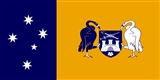
Australian Capital Territory
Encyclopedia
The Australian Capital Territory, often abbreviated ACT, is the capital territory of the Commonwealth of Australia and is the smallest self-governing internal territory
. It is enclaved
within New South Wales
and is regularly referred to as Australia's 'Bush Capital
'.
The need for a National Territory was flagged by colonial delegates during the Federation
conventions of the late 19th century. Section 125 of the Australian Constitution
provided that following Federation in 1901, land would be ceded freely to the new Federal Government
. The territory was transferred to the Commonwealth by the state of New South Wales
in 1911, two years prior to the naming of Canberra
as the National Capital in 1913. The floral emblem of the ACT is the Royal Bluebell
and the bird emblem is the Gang-gang Cockatoo
.
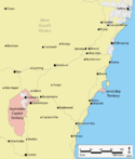 The ACT is bounded by the Goulburn
-Cooma
railway line in the east, the watershed of Naas Creek
in the south, the watershed of the Cotter River
in the west, and the watershed of the Molonglo River
in the north-east. The ACT also has a small strip of territory around the southern end of the Beecroft Peninsula
, which is the northern headland of Jervis Bay
.
Apart from the city of Canberra, the Australian Capital Territory also contains agricultural land (sheep
, dairy cattle
, vineyard
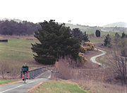
s and small amounts of crops) and a large area of national park (Namadgi National Park
), much of it mountainous and forested. Small townships and communities located within the ACT include Williamsdale, Naas
, Uriarra
, Tharwa
and Hall
.
Tidbinbilla is a locality to the south-west of Canberra that features the Tidbinbilla Nature Reserve
and the Canberra Deep Space Communication Complex
, operated by the United States' National Aeronautics and Space Administration
(NASA) as part of its Deep Space Network
.
There are a large range of mountains, rivers and creeks in the Namadgi National Park. These include the Naas and Murrumbidgee Rivers.
and frequent frost
s. Many of the higher mountains in the territory's south-west are snow-covered for at least part of the winter. Thunderstorm
s can occur between October and March, and annual rainfall is 623 millimetres (24.5 in), with rainfall highest in spring and summer and lowest in winter.
The highest maximum temperature recorded in the ACT was 42.8 °C (109.0 °F) at Acton
on 11 January 1939. The lowest minimum temperature was −14.6 °C (5.7 °F) at Gudgenby on 11 July 1971.
In the 1840s fossil
s of brachiopod
s and trilobite
s from the Silurian
period were discovered at Woolshed Creek near Duntroon
. At the time, these were the oldest fossils discovered in Australia, though this record has now been far surpassed. Other specific geological places of interest include the State Circle cutting and the Deakin anticline.
The oldest rocks in the ACT date from the Ordovician
around 480 million years ago. During this period the region along with most of Eastern Australia was part of the ocean floor; formations from this period include the Black Mountain Sandstone formation and the Pittman Formation consisting largely of quartz
-rich sandstone
, siltstone
and shale
. These formations became exposed when the ocean floor was raised by a major volcanic activity
in the Devonian
forming much of the east coast of Australia.
does not afford the territory government the full legislative independence provided to Australian states. Laws are made in a 17-member Legislative Assembly
that has all state and local government functions. However, its decisions can be overruled by the Australian Governor-General
(effectively by the national government) under section 35 of the Australian Capital Territory (Self-Government) Act 1988. (See also Electoral systems of the Australian states and territories
). Members of the Legislative Assembly are elected via the Hare Clarke
system. The ACT Chief Minister (currently Katy Gallagher
, Australian Labor Party
) is elected by members of the ACT Assembly. The ACT Government is a member of the Council of Australian Governments
.
Unlike other self-governing Australian territories (e.g. Norfolk Island
, Northern Territory), the ACT does not have an Administrator. The Crown is represented by the Governor-General in the government of the ACT. The Chief Minister performs many of the roles that a state governor normally holds in the context of a state, however the Speaker of the Legislative Assembly gazettes the laws and summons meetings of the Assembly.
In Australia's Federal Parliament
, the ACT is represented by four federal members: two members of the House of Representatives
; the Division of Fraser
and the Division of Canberra
and is one of only two territories to be represented in the Senate, with two Senators
(the other being the Northern Territory). The Member for Fraser and the ACT Senators also represent the constituents of the Jervis Bay Territory
.
In 1915 the Jervis Bay Territory Acceptance Act 1915
created the Jervis Bay Territory
as an annexe to the Australian Capital Territory. In 1988, when the ACT gained self-government, Jervis Bay became a separate territory administered by the Australian Government Minister responsible for Territories, presently the Minister for Home Affairs (Australia)
.
The ACT retains a small area of territory on the coast on the Beecroft Peninsula
, consisting of a strip of coastline around the northern headland of Jervis Bay (not to be confused with the Jervis Bay Territory, which is on the southern headland of the Bay). The ACT's land on the Beecroft Peninsula is an "exclave", that is, an area of territory not physically connected to the main part of the ACT. Interestingly, this ACT exclave surrounds a small exclave of NSW territory, namely the Point Perpendicular
lighthouse which is at the southern tip of the Beecroft Peninsula. The lighthouse and its grounds are New South Wales territory, but cut off from the rest of the state by the strip of ACT land. This is a geographic curiosity: an exclave of NSW land enclosed by an exclave of ACT land.
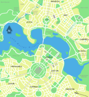
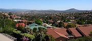
 Canberra is a planned city
that was originally designed by Walter Burley Griffin
, a major 20th century American architect. Major roads follow a wheel-and-spoke pattern rather than a grid. The city centre is laid out on two perpendicular axes: a water axis stretching along Lake Burley Griffin
, and a ceremonial land axis stretching from Parliament House on Capital Hill
north-eastward along ANZAC Parade
to the Australian War Memorial
at the foot of Mount Ainslie.
The area known as the Parliamentary Triangle
is formed by three of Burley Griffin's axes, stretching from Capital Hill along Commonwealth Avenue
to the Civic Centre around City Hill, along Constitution Avenue to the Defence precinct on Russell Hill, and along Kings Avenue back to Capital Hill.
The larger scheme of Canberra's layout is based on the three peaks surrounding the city, Mount Ainslie
, Black Mountain
, and Red Hill
. The main symmetrical axis of the city is along ANZAC Parade
and roughly on the line between Mount Ainslie and Bimberi Peak
. Bimberi Peak being the highest mountain in the ACT approximately 52 km (32 mi) south west of Canberra . The precise alignment of ANZAC parade is between Mount Ainslie and Capital Hill
(formally Kurrajong Hill).
The Griffins
assigned spiritual values to Mount Ainslie, Black Mountain, and Red Hill and originally planned to cover each of these in flowers. That way each hill would be covered with a single, primary color which represented its spiritual value. This part of their plan never came to fruition. In fact, WWI interrupted the construction and some conflicts after the war made it a difficult process for the Griffins. Nevertheless, Canberra stands as an exemplary city design and is located halfway between the ski slopes and the beach. It enjoys a natural cooling from geophysical factors.
The urban areas of Canberra are organised into a hierarchy of districts, town centres, group centres, local suburbs as well as other industrial areas and villages. There are seven districts (with an eighth currently under construction), each of which is divided into smaller suburbs, and most of which have a town centre which is the focus of commercial and social activities. The districts were settled in the following chronological order:
The North and South Canberra districts are substantially based on Walter Burley Griffin's designs. In 1967 the then National Capital Development Commission
adopted the "Y Plan" which laid out future urban development in Canberra around a series of central shopping and commercial area known as the 'town centres' linked by freeways, the layout of which roughly resembled the shape of the letter Y, with Tuggeranong at the base of the Y and Belconnen and Gungahlin located at the ends of the arms of the Y.
Development in Canberra has been closely regulated by government, both through the town planning process, but also through the use of crown lease terms that have tightly limited the use of parcels of land. All land in the ACT is held on 99 year leases from the national government, although most leases are now administered by the Territory government.
Most suburbs have their own local shops, and are located close to a larger shopping centre serving a group of suburbs. Community facilities and schools are often also located near local shops or group shopping centres. Many of Canberra's suburbs are named after former Prime Ministers, famous Australians, early settlers, or use Aboriginal words for their title.
Street name
s typically follow a particular theme; for example, the streets of Duffy
are named after Australian dams and reservoirs, the streets of Dunlop
are named after Australian inventions, inventors and artists and the streets of Page
are named after biologists and naturalists. Most diplomatic mission
s are located in the suburbs of Yarralumla
, Deakin
and O'Malley
. There are three light industrial areas: the suburbs of Fyshwick
, Mitchell
and Hume
.
. The ACT public education system schooling is normally split up into Pre-School, Primary School (K-6), High School (7–10) and College (11–12) followed by studies at university or TAFE. Many private high schools include years 11 and 12 and are referred to as colleges. Children are required to attend school until they turn 17 under the ACT Government's "Learn or Earn" policy.
In February 2004 there were 140 public and non-governmental schools in Canberra; 96 were operated by the Government and 44 are non-Government. In 2005 there were 60,275 students in the ACT school system. 59.3% of the students were enrolled in government schools with the remaining 40.7% in non-government schools. There were 30,995 students in primary school, 19,211 in high school, 9,429 in college and a further 340 in special schools.
As of May 2004, 30% of people in the ACT aged 15–64 had a level of educational attainment equal to at least an bachelor's degree
, significantly higher that the national average of 19%. The two main tertiary institutions are the Australian National University
(ANU) in Acton
and the University of Canberra
(UC) in Bruce
. There are also two religious university campuses in Canberra: Signadou is a campus of the Australian Catholic University
and St Mark's Theological College is a campus of Charles Sturt University
. The Australian International Hotel School
offers degree and diploma level courses and operates the Hotel Kurrajong in Barton
. Tertiary level vocational education is also available through the multi-campus Canberra Institute of Technology
.
The Australian Defence Force Academy
(ADFA) and the Royal Military College, Duntroon
(RMC) are in the suburb of Campbell
in Canberra's inner northeast. ADFA teaches military undergraduates and postgraduates and is officially a campus of the University of New South Wales
while Duntroon provides Australian Army
Officer
training
.
The Academy of Interactive Entertainment
(AIE) offers courses in computer game development and 3D animation.
States and territories of Australia
The Commonwealth of Australia is a union of six states and various territories. The Australian mainland is made up of five states and three territories, with the sixth state of Tasmania being made up of islands. In addition there are six island territories, known as external territories, and a...
. It is enclaved
Enclave and exclave
In political geography, an enclave is a territory whose geographical boundaries lie entirely within the boundaries of another territory.An exclave, on the other hand, is a territory legally or politically attached to another territory with which it is not physically contiguous.These are two...
within New South Wales
New South Wales
New South Wales is a state of :Australia, located in the east of the country. It is bordered by Queensland, Victoria and South Australia to the north, south and west respectively. To the east, the state is bordered by the Tasman Sea, which forms part of the Pacific Ocean. New South Wales...
and is regularly referred to as Australia's 'Bush Capital
The Bush
"The bush" is a term used for rural, undeveloped land or country areas in certain countries.-Australia:The term is iconic in Australia. In reference to the landscape, "bush" describes a wooded area, intermediate between a shrubland and a forest, generally of dry and nitrogen-poor soil, mostly...
'.
The need for a National Territory was flagged by colonial delegates during the Federation
Federation of Australia
The Federation of Australia was the process by which the six separate British self-governing colonies of New South Wales, Queensland, South Australia, Tasmania, Victoria and Western Australia formed one nation...
conventions of the late 19th century. Section 125 of the Australian Constitution
Constitution of Australia
The Constitution of Australia is the supreme law under which the Australian Commonwealth Government operates. It consists of several documents. The most important is the Constitution of the Commonwealth of Australia...
provided that following Federation in 1901, land would be ceded freely to the new Federal Government
Government of Australia
The Commonwealth of Australia is a federal constitutional monarchy under a parliamentary democracy. The Commonwealth of Australia was formed in 1901 as a result of an agreement among six self-governing British colonies, which became the six states...
. The territory was transferred to the Commonwealth by the state of New South Wales
New South Wales
New South Wales is a state of :Australia, located in the east of the country. It is bordered by Queensland, Victoria and South Australia to the north, south and west respectively. To the east, the state is bordered by the Tasman Sea, which forms part of the Pacific Ocean. New South Wales...
in 1911, two years prior to the naming of Canberra
Canberra
Canberra is the capital city of Australia. With a population of over 345,000, it is Australia's largest inland city and the eighth-largest city overall. The city is located at the northern end of the Australian Capital Territory , south-west of Sydney, and north-east of Melbourne...
as the National Capital in 1913. The floral emblem of the ACT is the Royal Bluebell
Wahlenbergia gloriosa
Wahlenbergia gloriosa, or Royal Bluebell, is an Australian wildflower from the Campanulaceae family. It grows in high rainfall areas in the Australian Alps, in environs ranging from shady roadside cuttings on Mount Hotham to full sun herbfields on the main range.W. gloriosa has small dark green...
and the bird emblem is the Gang-gang Cockatoo
Gang-gang Cockatoo
The Gang-gang Cockatoo, Callocephalon fimbriatum, is found in the cooler and wetter forests and woodlands of Australia, particularly alpine bushland. Mostly mild grey in colour with some lighter scalloping the male has a red head and crest, while the female has a small fluffy grey crest...
.
Geography
Goulburn, New South Wales
Goulburn is a provincial city in the Southern Tablelands of New South Wales, Australia in Goulburn Mulwaree Council Local Government Area. It is located south-west of Sydney on the Hume Highway and above sea-level. On Census night 2006, Goulburn had a population of 20,127 people...
-Cooma
Cooma, New South Wales
-Education: is Cooma's only public high school, it serves the town and seven of the neighbouring rural towns and villages such as Berridale, Jindabyne, Nimmitabel, Bredbo and Dalgety....
railway line in the east, the watershed of Naas Creek
Naas (valley)
Naas Valley is an area south of Canberra, Australia in the Brindabella Ranges which was first settled by Europeans in 1834. The watershed of Naas Creek forms the southern and south-eastern boundary of the Australian Capital Territory, as specified in the Seat of Government Acceptance Act 1909.The...
in the south, the watershed of the Cotter River
Cotter River
The Cotter River is a fresh water river in the Australian Capital Territory. It is a tributary of the Murrumbidgee River and part of Murray-Darling Basin. The Cotter River is one of two rivers—the Queanbeyan River is the other—that meet the water supply needs of the Canberra and...
in the west, and the watershed of the Molonglo River
Molonglo River
The Molonglo River rises on the western side of the Great Dividing Range of eastern Australia in the state of New South Wales. Its source is on the other side of the mountain range from where the Shoalhaven River rises, in Tallaganda state forest at ~1200 metres altitude...
in the north-east. The ACT also has a small strip of territory around the southern end of the Beecroft Peninsula
Beecroft Peninsula
Beecroft Peninsula is a peninsula located to the north and east of Jervis Bay in south-eastern Australia. The peninsula forms the northern headland of Jervis Bay....
, which is the northern headland of Jervis Bay
Jervis Bay Territory
The Jervis Bay Territory is a territory of the Commonwealth of Australia. It was surrendered by the state of New South Wales to the Commonwealth Government in 1915 so that the Federal capital at Canberra would have "access to the sea"....
.
Apart from the city of Canberra, the Australian Capital Territory also contains agricultural land (sheep
Domestic sheep
Sheep are quadrupedal, ruminant mammals typically kept as livestock. Like all ruminants, sheep are members of the order Artiodactyla, the even-toed ungulates. Although the name "sheep" applies to many species in the genus Ovis, in everyday usage it almost always refers to Ovis aries...
, dairy cattle
Dairy cattle
Dairy cattle are cattle cows bred for the ability to produce large quantities of milk, from which dairy products are made. Dairy cows generally are of the species Bos taurus....
, vineyard
Vineyard
A vineyard is a plantation of grape-bearing vines, grown mainly for winemaking, but also raisins, table grapes and non-alcoholic grape juice...
s and small amounts of crops) and a large area of national park (Namadgi National Park
Namadgi National Park
Namadgi National Park is located in the southwestern part of the Australian Capital Territory, bordering Kosciuszko National Park in New South Wales. It lies approximately 40 km southwest of Canberra, and makes up approximately 46% of the ACT's land area....
), much of it mountainous and forested. Small townships and communities located within the ACT include Williamsdale, Naas
Naas (valley)
Naas Valley is an area south of Canberra, Australia in the Brindabella Ranges which was first settled by Europeans in 1834. The watershed of Naas Creek forms the southern and south-eastern boundary of the Australian Capital Territory, as specified in the Seat of Government Acceptance Act 1909.The...
, Uriarra
Uriarra, Australian Capital Territory
Uriarra is a settlement in the Australian Capital Territory. It had been a forestry settlement from the 1920s to the 1980s.The 2003 bushfires destroyed 16 houses in Uriarra, with only 6 houses still standing afterwards...
, Tharwa
Tharwa, Australian Capital Territory
Tharwa is a small village within the Australian Capital Territory, south of Canberra, the capital city of Australia. At the 2006 census, Tharwa had a population of 109....
and Hall
Hall, Australian Capital Territory
Hall is a small town in the north of the Australian Capital Territory , Australia. It was founded in 1882, named after the first landholder in the area, Henry Hall. In 1911 Hall was included within the boundary of the land allocated for the Australian Capital Territory, close to the north western...
.
Tidbinbilla is a locality to the south-west of Canberra that features the Tidbinbilla Nature Reserve
Tidbinbilla Nature Reserve
Tidbinbilla Nature Reserve, on the fringe of Namadgi National Park, is a short drive from the city of Canberra, Australia. The reserve covers an area of approximately 54.50 km² and consists of a large valley floor, the Tidbinbilla Mountain and the Gibraltar range...
and the Canberra Deep Space Communication Complex
Canberra Deep Space Communication Complex
The Canberra Deep Space Communication Complex is a ground station that is located in Australia at Tidbinbilla in the Paddys River valley, about half an hour's drive out of Canberra in the Australian Capital Territory. The complex is part of the Deep Space Network run by NASA's Jet Propulsion...
, operated by the United States' National Aeronautics and Space Administration
NASA
The National Aeronautics and Space Administration is the agency of the United States government that is responsible for the nation's civilian space program and for aeronautics and aerospace research...
(NASA) as part of its Deep Space Network
Deep Space Network
The Deep Space Network, or DSN, is a world-wide network of large antennas and communication facilities that supports interplanetary spacecraft missions. It also performs radio and radar astronomy observations for the exploration of the solar system and the universe, and supports selected...
.
There are a large range of mountains, rivers and creeks in the Namadgi National Park. These include the Naas and Murrumbidgee Rivers.
Climate
Because of its elevation 650 metres (2,132.5 ft) and distance from the coast, the Australian Capital Territory experiences four distinct seasons, unlike many other Australian cities whose climates are moderated by the sea. Canberra is notorious for hot, dry summers, and cold winters with occasional fogFog
Fog is a collection of water droplets or ice crystals suspended in the air at or near the Earth's surface. While fog is a type of stratus cloud, the term "fog" is typically distinguished from the more generic term "cloud" in that fog is low-lying, and the moisture in the fog is often generated...
and frequent frost
Frost
Frost is the solid deposition of water vapor from saturated air. It is formed when solid surfaces are cooled to below the dew point of the adjacent air as well as below the freezing point of water. Frost crystals' size differ depending on time and water vapour available. Frost is also usually...
s. Many of the higher mountains in the territory's south-west are snow-covered for at least part of the winter. Thunderstorm
Thunderstorm
A thunderstorm, also known as an electrical storm, a lightning storm, thundershower or simply a storm is a form of weather characterized by the presence of lightning and its acoustic effect on the Earth's atmosphere known as thunder. The meteorologically assigned cloud type associated with the...
s can occur between October and March, and annual rainfall is 623 millimetres (24.5 in), with rainfall highest in spring and summer and lowest in winter.
The highest maximum temperature recorded in the ACT was 42.8 °C (109.0 °F) at Acton
Acton, Australian Capital Territory
Acton is a suburb of Canberra, Australia. Acton covers an area west of the CBD, bordered by Black Mountain to the west and Lake Burley Griffin in the south...
on 11 January 1939. The lowest minimum temperature was −14.6 °C (5.7 °F) at Gudgenby on 11 July 1971.
Geology
Notable geological formations in the Australian Capital Territory include the Canberra Formation, the Pittman Formation, Black Mountain Sandstone and State Circle Shale.In the 1840s fossil
Fossil
Fossils are the preserved remains or traces of animals , plants, and other organisms from the remote past...
s of brachiopod
Brachiopod
Brachiopods are a phylum of marine animals that have hard "valves" on the upper and lower surfaces, unlike the left and right arrangement in bivalve molluscs. Brachiopod valves are hinged at the rear end, while the front can be opened for feeding or closed for protection...
s and trilobite
Trilobite
Trilobites are a well-known fossil group of extinct marine arthropods that form the class Trilobita. The first appearance of trilobites in the fossil record defines the base of the Atdabanian stage of the Early Cambrian period , and they flourished throughout the lower Paleozoic era before...
s from the Silurian
Silurian
The Silurian is a geologic period and system that extends from the end of the Ordovician Period, about 443.7 ± 1.5 Mya , to the beginning of the Devonian Period, about 416.0 ± 2.8 Mya . As with other geologic periods, the rock beds that define the period's start and end are well identified, but the...
period were discovered at Woolshed Creek near Duntroon
Duntroon, Australian Capital Territory
Duntroon is a suburb of the city of Canberra in the Australian Capital Territory.-History:Robert Campbell's property Duntroon was situated on the limestone plains of New South Wales in the area that is now covered by the ACT....
. At the time, these were the oldest fossils discovered in Australia, though this record has now been far surpassed. Other specific geological places of interest include the State Circle cutting and the Deakin anticline.
The oldest rocks in the ACT date from the Ordovician
Ordovician
The Ordovician is a geologic period and system, the second of six of the Paleozoic Era, and covers the time between 488.3±1.7 to 443.7±1.5 million years ago . It follows the Cambrian Period and is followed by the Silurian Period...
around 480 million years ago. During this period the region along with most of Eastern Australia was part of the ocean floor; formations from this period include the Black Mountain Sandstone formation and the Pittman Formation consisting largely of quartz
Quartz
Quartz is the second-most-abundant mineral in the Earth's continental crust, after feldspar. It is made up of a continuous framework of SiO4 silicon–oxygen tetrahedra, with each oxygen being shared between two tetrahedra, giving an overall formula SiO2. There are many different varieties of quartz,...
-rich sandstone
Sandstone
Sandstone is a sedimentary rock composed mainly of sand-sized minerals or rock grains.Most sandstone is composed of quartz and/or feldspar because these are the most common minerals in the Earth's crust. Like sand, sandstone may be any colour, but the most common colours are tan, brown, yellow,...
, siltstone
Siltstone
Siltstone is a sedimentary rock which has a grain size in the silt range, finer than sandstone and coarser than claystones.- Description :As its name implies, it is primarily composed of silt sized particles, defined as grains 1/16 - 1/256 mm or 4 to 8 on the Krumbein phi scale...
and shale
Shale
Shale is a fine-grained, clastic sedimentary rock composed of mud that is a mix of flakes of clay minerals and tiny fragments of other minerals, especially quartz and calcite. The ratio of clay to other minerals is variable. Shale is characterized by breaks along thin laminae or parallel layering...
. These formations became exposed when the ocean floor was raised by a major volcanic activity
Orogeny
Orogeny refers to forces and events leading to a severe structural deformation of the Earth's crust due to the engagement of tectonic plates. Response to such engagement results in the formation of long tracts of highly deformed rock called orogens or orogenic belts...
in the Devonian
Devonian
The Devonian is a geologic period and system of the Paleozoic Era spanning from the end of the Silurian Period, about 416.0 ± 2.8 Mya , to the beginning of the Carboniferous Period, about 359.2 ± 2.5 Mya...
forming much of the east coast of Australia.
Governance
The ACT has internal self-government, but Australia's ConstitutionConstitution of Australia
The Constitution of Australia is the supreme law under which the Australian Commonwealth Government operates. It consists of several documents. The most important is the Constitution of the Commonwealth of Australia...
does not afford the territory government the full legislative independence provided to Australian states. Laws are made in a 17-member Legislative Assembly
Australian Capital Territory Legislative Assembly
The Australian Capital Territory Legislative Assembly is the unicameral legislature of the Australian Capital Territory...
that has all state and local government functions. However, its decisions can be overruled by the Australian Governor-General
Governor-General of Australia
The Governor-General of the Commonwealth of Australia is the representative in Australia at federal/national level of the Australian monarch . He or she exercises the supreme executive power of the Commonwealth...
(effectively by the national government) under section 35 of the Australian Capital Territory (Self-Government) Act 1988. (See also Electoral systems of the Australian states and territories
Electoral systems of the Australian states and territories
The legislatures of the Australian states and territories all follow the Westminster model described in the Australian electoral system. When the Australian colonies were granted responsible government in the nineteenth century, their constitutions provided for legislative assemblies elected by...
). Members of the Legislative Assembly are elected via the Hare Clarke
Single transferable vote
The single transferable vote is a voting system designed to achieve proportional representation through preferential voting. Under STV, an elector's vote is initially allocated to his or her most preferred candidate, and then, after candidates have been either elected or eliminated, any surplus or...
system. The ACT Chief Minister (currently Katy Gallagher
Katy Gallagher
Katy Gallagher , an Australian politician, is the sixth and current Chief Minister of the Australian Capital Territory and a member of the Australian Capital Territory Legislative Assembly since 2001, representing the electorate of Molonglo for the Australian Labor Party...
, Australian Labor Party
Australian Labor Party
The Australian Labor Party is an Australian political party. It has been the governing party of the Commonwealth of Australia since the 2007 federal election. Julia Gillard is the party's federal parliamentary leader and Prime Minister of Australia...
) is elected by members of the ACT Assembly. The ACT Government is a member of the Council of Australian Governments
Council of Australian Governments
The Council of Australian Governments is an organisation consisting of the federal government, the governments of the six states and two mainland territories and the Australian Local Government Association. It was established in May 1992 after agreement by the then Prime Minister, Premiers and...
.
Unlike other self-governing Australian territories (e.g. Norfolk Island
Norfolk Island
Norfolk Island is a small island in the Pacific Ocean located between Australia, New Zealand and New Caledonia. The island is part of the Commonwealth of Australia, but it enjoys a large degree of self-governance...
, Northern Territory), the ACT does not have an Administrator. The Crown is represented by the Governor-General in the government of the ACT. The Chief Minister performs many of the roles that a state governor normally holds in the context of a state, however the Speaker of the Legislative Assembly gazettes the laws and summons meetings of the Assembly.
In Australia's Federal Parliament
Parliament of Australia
The Parliament of Australia, also known as the Commonwealth Parliament or Federal Parliament, is the legislative branch of the government of Australia. It is bicameral, largely modelled in the Westminster tradition, but with some influences from the United States Congress...
, the ACT is represented by four federal members: two members of the House of Representatives
Australian House of Representatives
The House of Representatives is one of the two houses of the Parliament of Australia; it is the lower house; the upper house is the Senate. Members of Parliament serve for terms of approximately three years....
; the Division of Fraser
Division of Fraser
The Division of Fraser is an Australian Electoral Division in the Australian Capital Territory. It also covers the Jervis Bay Territory.The division was created in 1974 and is named for James Fraser, who was member for Australian Capital Territory 1951-70...
and the Division of Canberra
Division of Canberra
The Division of Canberra is an Australian Electoral Division in the Australian Capital Territory. The division was created in 1974 from the southern half of the old Division of Australian Capital Territory...
and is one of only two territories to be represented in the Senate, with two Senators
Australian Senate
The Senate is the upper house of the bicameral Parliament of Australia, the lower house being the House of Representatives. Senators are popularly elected under a system of proportional representation. Senators are elected for a term that is usually six years; after a double dissolution, however,...
(the other being the Northern Territory). The Member for Fraser and the ACT Senators also represent the constituents of the Jervis Bay Territory
Jervis Bay Territory
The Jervis Bay Territory is a territory of the Commonwealth of Australia. It was surrendered by the state of New South Wales to the Commonwealth Government in 1915 so that the Federal capital at Canberra would have "access to the sea"....
.
In 1915 the Jervis Bay Territory Acceptance Act 1915
Jervis Bay Territory Acceptance Act 1915
The Jervis Bay Territory Acceptance Act 1915 was an Act of the Parliament of Australia which followed the New South Wales, Seat of Government Surrender Act 1915. The Act created the Territory of Jervis Bay, as a part of the Federal Capital Territory and with all laws of the FCT...
created the Jervis Bay Territory
Jervis Bay Territory
The Jervis Bay Territory is a territory of the Commonwealth of Australia. It was surrendered by the state of New South Wales to the Commonwealth Government in 1915 so that the Federal capital at Canberra would have "access to the sea"....
as an annexe to the Australian Capital Territory. In 1988, when the ACT gained self-government, Jervis Bay became a separate territory administered by the Australian Government Minister responsible for Territories, presently the Minister for Home Affairs (Australia)
Minister for Home Affairs (Australia)
The Australian Minister for Home Affairs has been Brendan O'Connor since 6 June 2009. The Home Affairs portfolio brings together agencies such as the Australian Customs Service , the Australian Federal Police and the Australian Security Intelligence Organisation, which were previously the...
.
The ACT retains a small area of territory on the coast on the Beecroft Peninsula
Beecroft Peninsula
Beecroft Peninsula is a peninsula located to the north and east of Jervis Bay in south-eastern Australia. The peninsula forms the northern headland of Jervis Bay....
, consisting of a strip of coastline around the northern headland of Jervis Bay (not to be confused with the Jervis Bay Territory, which is on the southern headland of the Bay). The ACT's land on the Beecroft Peninsula is an "exclave", that is, an area of territory not physically connected to the main part of the ACT. Interestingly, this ACT exclave surrounds a small exclave of NSW territory, namely the Point Perpendicular
Point Perpendicular
Point Perpendicular is a point at the southern tip of the Beecroft Peninsula and at the northern entry to Jervis Bay, in New South Wales, Australia...
lighthouse which is at the southern tip of the Beecroft Peninsula. The lighthouse and its grounds are New South Wales territory, but cut off from the rest of the state by the strip of ACT land. This is a geographic curiosity: an exclave of NSW land enclosed by an exclave of ACT land.
Administration
ACT Ministers implement their executive powers through the following government departments and agencies:- ACT Health and
- ACT Planning and Land AuthorityAustralian Capital Territory Planning and Land AuthorityThe Planning and Land Authority is an agency of the Government of the Australian Capital Territory, which advises the Minister for Planning, currently Andrew Barr.The Authority states that under the ACT Planning and Land Act 2002, it is required to:...
- the Chief Minister's DepartmentAustralian Capital Territory Chief Minister's DepartmentThe Chief Minister’s Department is the department of the Government of the Australian Capital Territory, which advises the ACT Chief Minister, currently Katy Gallagher....
- the Department of Disability, Housing and Community Services
- the Department of Education and Training
- the Department of Justice and Community Safety
- the Department of Territory and Municipal ServicesAustralian Capital Territory Department of Territory and Municipal ServicesThe Territory and Municipal Services Directorate is a Directorate of the Australian Capital Territory Government and delivers a wide range of services that Canberrans rely on every day: for example, recycling and collecting waste, running public libraries and ensuring municipal infrastructure such...
- the Department of Treasury
Demographics
In the 2006 census the population of the ACT was 333,667, of which only 869 were outside Canberra. The ACT median weekly income for people aged over 15 was in the range $600–$699 while the population living outside Canberra was at the national average of $400–$499. The average level of degree qualification in the ACT is higher than the national average. Within the ACT 4.5% of the population have a postgraduate degree compared to 1.8% across the whole of Australia.Urban Structure
New town
A new town is a specific type of a planned community, or planned city, that was carefully planned from its inception and is typically constructed in a previously undeveloped area. This contrasts with settlements that evolve in a more ad hoc fashion. Land use conflicts are uncommon in new...
that was originally designed by Walter Burley Griffin
Walter Burley Griffin
Walter Burley Griffin was an American architect and landscape architect, who is best known for his role in designing Canberra, Australia's capital city...
, a major 20th century American architect. Major roads follow a wheel-and-spoke pattern rather than a grid. The city centre is laid out on two perpendicular axes: a water axis stretching along Lake Burley Griffin
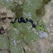
Lake Burley Griffin
Lake Burley Griffin is an artificial lake in the centre of Canberra, the capital of Australia. It was completed in 1963 after the Molonglo River—which ran between the city centre and Parliamentary Triangle—was dammed...
, and a ceremonial land axis stretching from Parliament House on Capital Hill
Capital Hill, Australian Capital Territory
Capital Hill , is the location of Parliament House, Canberra, at the south apex of the land axis of the Parliamentary Triangle....
north-eastward along ANZAC Parade
ANZAC Parade, Canberra
This article is about the road in Canberra. For other uses, see Anzac Parade .ANZAC Parade, a significant road and thoroughfare in the Australian capital Canberra, is used for ceremonial occasions and is the site of many major military memorials.Named in honour of the Australian and New Zealand...
to the Australian War Memorial
Australian War Memorial
The Australian War Memorial is Australia's national memorial to the members of all its armed forces and supporting organisations who have died or participated in the wars of the Commonwealth of Australia...
at the foot of Mount Ainslie.
The area known as the Parliamentary Triangle
Parliamentary Triangle, Canberra
The Parliamentary Triangle is the ceremonial precinct of Canberra, containing some of Australia's most significant buildings. The triangle is formed by Commonwealth, Kings and Constitution avenues...
is formed by three of Burley Griffin's axes, stretching from Capital Hill along Commonwealth Avenue
Commonwealth Avenue, Canberra
Commonwealth Avenue is a major road in Canberra, Australian Capital Territory, Australia. It connects Civic with South Canberra. Specifically, it runs between City Hill and Capital Hill....
to the Civic Centre around City Hill, along Constitution Avenue to the Defence precinct on Russell Hill, and along Kings Avenue back to Capital Hill.
The larger scheme of Canberra's layout is based on the three peaks surrounding the city, Mount Ainslie
Mount Ainslie (Australian Capital Territory)
Mount Ainslie or Mount Ainslie-Majura is a part of Canberra Nature Park. It borders on the inner suburbs of Campbell, Ainslie and Hackett...
, Black Mountain
Black Mountain (Australian Capital Territory)
Black Mountain is situated close to the central business district of Australia's capital city Canberra. Like all major hills in Canberra it is protected from development by the Canberra Nature Park. It is covered in native bushland and is a haven to native wildlife.With its peak at 811.987m AHD,...
, and Red Hill
Red Hill, Australian Capital Territory
Red Hill is a suburb of Canberra, Australian Capital Territory, Australia. The suburb is named after the northernmost hill of the ridge to the west of the suburb. The ridge is a reserve and managed as part of the Canberra Nature Park. The hill is an element of the central Canberra design...
. The main symmetrical axis of the city is along ANZAC Parade
ANZAC Parade, Canberra
This article is about the road in Canberra. For other uses, see Anzac Parade .ANZAC Parade, a significant road and thoroughfare in the Australian capital Canberra, is used for ceremonial occasions and is the site of many major military memorials.Named in honour of the Australian and New Zealand...
and roughly on the line between Mount Ainslie and Bimberi Peak
Bimberi Peak
Bimberi Peak or Mount Bimberi is the highest mountain in the Australian Capital Territory at 1912 metres. It is located on the border between New South Wales and the ACT, the NSW portion in Kosciuszko National Park and the ACT portion in Namadgi National Park...
. Bimberi Peak being the highest mountain in the ACT approximately 52 km (32 mi) south west of Canberra . The precise alignment of ANZAC parade is between Mount Ainslie and Capital Hill
Capital Hill, Australian Capital Territory
Capital Hill , is the location of Parliament House, Canberra, at the south apex of the land axis of the Parliamentary Triangle....
(formally Kurrajong Hill).
The Griffins
Walter Burley Griffin
Walter Burley Griffin was an American architect and landscape architect, who is best known for his role in designing Canberra, Australia's capital city...
assigned spiritual values to Mount Ainslie, Black Mountain, and Red Hill and originally planned to cover each of these in flowers. That way each hill would be covered with a single, primary color which represented its spiritual value. This part of their plan never came to fruition. In fact, WWI interrupted the construction and some conflicts after the war made it a difficult process for the Griffins. Nevertheless, Canberra stands as an exemplary city design and is located halfway between the ski slopes and the beach. It enjoys a natural cooling from geophysical factors.
The urban areas of Canberra are organised into a hierarchy of districts, town centres, group centres, local suburbs as well as other industrial areas and villages. There are seven districts (with an eighth currently under construction), each of which is divided into smaller suburbs, and most of which have a town centre which is the focus of commercial and social activities. The districts were settled in the following chronological order:
- North CanberraNorth CanberraNorth Canberra, also known as the Inner North, is a district of Canberra, the capital city of Australia, comprising 14 suburbs with 19,115 dwellings housing 42,113 people of the 324,034 people in the Australian Capital Territory...
, mostly settled in the 1920s and '30s, with expansion up to the 1960s, now 14 suburbs - South CanberraSouth CanberraSouth Canberra or the Inner South is a central district of Canberra, the capital city of Australia.South Canberra is located to the south of Canberra's city centre, on the south bank of Lake Burley Griffin....
, settled from the 1920s to '60s, 13 suburbs - Woden ValleyWoden ValleyWoden Valley is a district of Canberra, the capital city of Australia. Its name is taken from the name of a nearby homestead owned by Dr James Murray who named the homestead after the Old English god Woden in October 1837. He named it this as he was to spend his life in the pursuit of wisdom and...
, first settled in 1963, 12 suburbs - BelconnenBelconnenBelconnen is a district of Canberra, the capital city of Australia, comprising 25 suburbs with 29,900 dwellings housing 82,247 people of the 311,518 people in the Australian Capital Territory ....
, first settled in 1967, 25 suburbs - Weston CreekWeston CreekWeston Creek is a residential district of Canberra, Australian Capital Territory, Australia, situated to the west of the Woden Valley district and approximately 13 km southwest of the Canberra city centre...
, settled in 1969, 8 suburbs - TuggeranongTuggeranongTuggeranong is the southernmost town centre of Canberra, the capital city of Australia. It comprises 19 suburbs with a total of 31,819 dwellings, housing 87,119 people of the 324,034 people in the Australian Capital Territory . The district occupies 117 square kilometres to the east of the...
, settled in 1974, 19 suburbs - GungahlinGungahlinGungahlin is a name of a district and the northernmost town centre of Canberra, Australia. Gungahlin is situated 10 km north of Canberra's city centre and is one of five satellites of Canberra including Woden, Tuggeranong, Weston Creek and Belconnen. Currently Gungahlin comprises 11 suburbs,...
, settled in the early 1990s, 18 suburbs although only 12 are developed or under development - Molonglo ValleyMolonglo ValleyMolonglo Valley is the newest district of Canberra. The district is planned to consist of 13 suburbs containing 33,000 dwellings with an expected population of 73,000....
, first suburbs currently under construction
The North and South Canberra districts are substantially based on Walter Burley Griffin's designs. In 1967 the then National Capital Development Commission
National Capital Development Commission
The National Capital Development Commission was an Australian Commonwealth Government body created to complete the establishment of Canberra as the seat of government. It was created in 1957 through the National Capital Development Commission Act 1957.Under the control of the NCDC Canberra grew...
adopted the "Y Plan" which laid out future urban development in Canberra around a series of central shopping and commercial area known as the 'town centres' linked by freeways, the layout of which roughly resembled the shape of the letter Y, with Tuggeranong at the base of the Y and Belconnen and Gungahlin located at the ends of the arms of the Y.
Development in Canberra has been closely regulated by government, both through the town planning process, but also through the use of crown lease terms that have tightly limited the use of parcels of land. All land in the ACT is held on 99 year leases from the national government, although most leases are now administered by the Territory government.
Most suburbs have their own local shops, and are located close to a larger shopping centre serving a group of suburbs. Community facilities and schools are often also located near local shops or group shopping centres. Many of Canberra's suburbs are named after former Prime Ministers, famous Australians, early settlers, or use Aboriginal words for their title.
Street name
Street name
A street name or odonym is an identifying name given to a street. The street name usually forms part of the address...
s typically follow a particular theme; for example, the streets of Duffy
Duffy, Australian Capital Territory
Duffy is a suburb in the Canberra district of Weston Creek. On Census night 2006, Duffy had a population of 2,942 people. Duffy was named in honour of Sir Charles Gavan Duffy, KCMG the 8th Premier of Victoria. Streets in the suburb of Duffy are named after Australian dams and reservoirs...
are named after Australian dams and reservoirs, the streets of Dunlop
Dunlop, Australian Capital Territory
Dunlop is a suburb of Belconnen, Australian Capital Territory, Australia. Dunlop is located at the far north-west edge of Canberra, nearby the border with the state of New South Wales. Located approximately 11.6 kilometers north-west of the city, Dunlop is situated next to the suburbs of Fraser,...
are named after Australian inventions, inventors and artists and the streets of Page
Page, Australian Capital Territory
Page is a suburb of Canberra, in the district of Belconnen. The suburb is named in honour of Sir Earle Page, a former Prime Minister. Streets in Page are named in honour of Australian scientists...
are named after biologists and naturalists. Most diplomatic mission
Diplomatic mission
A diplomatic mission is a group of people from one state or an international inter-governmental organisation present in another state to represent the sending state/organisation in the receiving state...
s are located in the suburbs of Yarralumla
Yarralumla, Australian Capital Territory
Yarralumla is a large inner south suburb of Canberra, the capital city of Australia. Located approximately south-west of the city, Yarralumla extends along the south-west bank of Lake Burley Griffin...
, Deakin
Deakin, Australian Capital Territory
Deakin is a suburb of Canberra, Australian Capital Territory, Australia. Deakin is named after Alfred Deakin, second prime minister of Australia...
and O'Malley
O'Malley, Australian Capital Territory
O'Malley is a suburb in the Canberra district of Woden Valley. On Census night 2006, O'Malley had a population of 684 people. There are numerous embassies in O'Malley....
. There are three light industrial areas: the suburbs of Fyshwick
Fyshwick, Australian Capital Territory
Fyshwick is an industrial suburb of Canberra, located east of the South Canberra district. On Census night 2006, Fyshwick had a population of 54 people....
, Mitchell
Mitchell, Australian Capital Territory
Mitchell is a light-industrial estate of Canberra, Australia in the district of Gungahlin. Mitchell was named in honour of Major Sir Thomas Livingston Mitchell, an explorer of inland New South Wales and Surveyor-General of New South Wales. The streets in Mitchell are named after Australian...
and Hume
Hume, Australian Capital Territory
Hume is a suburb of Canberra in the district of Tuggeranong. The suburb is named after the explorer Hamilton Hume and streets are named after Australian industrialists and businessmen. Hume is a light-industrial suburb and there is no significant housing development...
.
Education
Almost all educational institutions in the Australian Capital Territory are located within CanberraCanberra
Canberra is the capital city of Australia. With a population of over 345,000, it is Australia's largest inland city and the eighth-largest city overall. The city is located at the northern end of the Australian Capital Territory , south-west of Sydney, and north-east of Melbourne...
. The ACT public education system schooling is normally split up into Pre-School, Primary School (K-6), High School (7–10) and College (11–12) followed by studies at university or TAFE. Many private high schools include years 11 and 12 and are referred to as colleges. Children are required to attend school until they turn 17 under the ACT Government's "Learn or Earn" policy.
In February 2004 there were 140 public and non-governmental schools in Canberra; 96 were operated by the Government and 44 are non-Government. In 2005 there were 60,275 students in the ACT school system. 59.3% of the students were enrolled in government schools with the remaining 40.7% in non-government schools. There were 30,995 students in primary school, 19,211 in high school, 9,429 in college and a further 340 in special schools.
As of May 2004, 30% of people in the ACT aged 15–64 had a level of educational attainment equal to at least an bachelor's degree
Bachelor's degree
A bachelor's degree is usually an academic degree awarded for an undergraduate course or major that generally lasts for three or four years, but can range anywhere from two to six years depending on the region of the world...
, significantly higher that the national average of 19%. The two main tertiary institutions are the Australian National University
Australian National University
The Australian National University is a teaching and research university located in the Australian capital, Canberra.As of 2009, the ANU employs 3,945 administrative staff who teach approximately 10,000 undergraduates, and 7,500 postgraduate students...
(ANU) in Acton
Acton, Australian Capital Territory
Acton is a suburb of Canberra, Australia. Acton covers an area west of the CBD, bordered by Black Mountain to the west and Lake Burley Griffin in the south...
and the University of Canberra
University of Canberra
Over the years the Stone Day program has gradually become larger and larger, taking up a whole week and now Stonefest is one of Australia's most popular music festivals. The first foundation celebrations were held in 1971. In 1973 Stone Day celebrations were held over two days, which was expanded...
(UC) in Bruce
Bruce, Australian Capital Territory
Bruce is a suburb of Canberra, Australian Capital Territory, Australia. Bruce was gazetted as a division on 6 June 1968 in recognition of Viscount Stanley Melbourne Bruce, the first Chancellor of the Australian National University and eighth Prime Minister of Australia. S. M. Bruce served as...
. There are also two religious university campuses in Canberra: Signadou is a campus of the Australian Catholic University
Australian Catholic University
Australian Catholic University is a national public university. It has six campuses and offers programs in five faculties throughout Australia.-History:...
and St Mark's Theological College is a campus of Charles Sturt University
Charles Sturt University
Charles Sturt University is an Australian multi-campus university located in New South Wales, Victoria, and the Australian Capital Territory. It has campuses at Bathurst, Canberra, Albury-Wodonga, Dubbo, Goulburn, Orange, Wagga Wagga and Burlington, Ontario...
. The Australian International Hotel School
Australian International Hotel School
The Australian International Hotel School is a university-level provider of hotel management education, located in Canberra, Australia’s Capital...
offers degree and diploma level courses and operates the Hotel Kurrajong in Barton
Barton, Australian Capital Territory
Barton is a suburb of Canberra, Australian Capital Territory, Australia. Barton is named after Sir Edmund Barton, Australia's first Prime Minister. Streets in Barton are named after Governors....
. Tertiary level vocational education is also available through the multi-campus Canberra Institute of Technology
Canberra Institute of Technology
The Canberra Institute of Technology is a vocational education provider in Canberra, the Australian Capital Territory, and is one of a system of TAFEs. Qualifications offered by CIT range from certificate to degree level. CIT has four campuses across Canberra, located in Bruce, Reid, Phillip and...
.
The Australian Defence Force Academy
Australian Defence Force Academy
The Australian Defence Force Academy is a tri-service military Academy that provides military and tertiary academic education for junior officers of the Australian Defence Force in the Royal Australian Navy , Australian Army and Royal Australian Air Force .Tertiary education is provided by the...
(ADFA) and the Royal Military College, Duntroon
Royal Military College, Duntroon
The Royal Military College, Duntroon is the Australian Army's officer training establishment. It was founded at Duntroon, in the Australian Capital Territory, in 1911 and is situated on picturesque grounds at the foot of Mount Pleasant near Lake Burley Griffin, close to the Department of Defence...
(RMC) are in the suburb of Campbell
Campbell, Australian Capital Territory
Campbell is a suburb of Canberra, Australian Capital Territory, Australia. Covering an area to the South East of the central business district, Campbell sits at the base of Mount Ainslie. On Census night 2006, Campbell had a population of 4,797 people...
in Canberra's inner northeast. ADFA teaches military undergraduates and postgraduates and is officially a campus of the University of New South Wales
University of New South Wales
The University of New South Wales , is a research-focused university based in Kensington, a suburb in Sydney, New South Wales, Australia...
while Duntroon provides Australian Army
Australian Army
The Australian Army is Australia's military land force. It is part of the Australian Defence Force along with the Royal Australian Navy and the Royal Australian Air Force. While the Chief of Defence commands the Australian Defence Force , the Army is commanded by the Chief of Army...
Officer
Officer (armed forces)
An officer is a member of an armed force or uniformed service who holds a position of authority. Commissioned officers derive authority directly from a sovereign power and, as such, hold a commission charging them with the duties and responsibilities of a specific office or position...
training
Training
The term training refers to the acquisition of knowledge, skills, and competencies as a result of the teaching of vocational or practical skills and knowledge that relate to specific useful competencies. It forms the core of apprenticeships and provides the backbone of content at institutes of...
.
The Academy of Interactive Entertainment
Academy of Interactive Entertainment
The Academy of Interactive Entertainment is an Australian video games and 3D animation school. Founded in 1996, it was one of the world's first institutions to offer qualifications in these industries. The AIE provides courses covering CGI, animation, video game asset creation and games programming...
(AIE) offers courses in computer game development and 3D animation.
See also
- History of the Australian Capital TerritoryHistory of the Australian Capital TerritoryThe history of the Australian Capital Territory as an administrative division of Australia began after the Federation of Australia in 1901, when it was created in law as the site for Canberra, Australia's capital city...