

History of Garrett County, Maryland
Encyclopedia
The History of Garrett County, Maryland began in 1632, when Charles I of England
granted a charter that lead to the creation of the Province of Maryland
, a proprietary colony
. In 1696, the western part of the Province of Maryland, including the present Garrett County, was incorporated into Prince George's County
. This county included six current State of Maryland counties, and by repeated splitting, new ones were created:
In 1872, Garrett County was formed from the western sections of Allegany County and has the distinction of being the last county created within the state of Maryland
.
came through the area in 1851 the people began to take a different look at the natural resources. The railroad's arrival meant access to East Coast markets and eventually to nationwide markets. Towns grew and citizens became more prosperous, and with the new prosperity came questions about taxation and representation, as well as appropriations.
Local grumbling about lack of representation resembled the cry of 1776, "No taxation without representation
!". Many prominent citizens could see beyond Cumberland
, the Allegany County
seat of government, to Annapolis
, the State Capital, and the fact that men from Cumberland dominated as the Western Maryland
representatives in the Maryland Legislature.
Around 1870, a movement to form a new county became active under the leadership of Patrick Hamill
and Colonel James M. Schley. They wanted a county, separate from Allegany County, to include all the land west of Big Savage Mountain. They formed a committee in 1871 and presented a petition to the Maryland General Assembly
for the division of Allegany to form a new county; two possible names for the proposed county were, Glades and Garrett.
Once more, as in 1776, printed matter helped to solidify public opinion. In August 1871, E.S. Zevely of Oakland
began the publication of a weekly newspaper called the Glades Star. He selected "Work For The New County" as a slogan for his paper. Among other things in his editorials, he pointed out the fact that residents of the Districts of Allegany County to be included in proposed new county paid $28,000 in taxes under the existing Allegany County tax levy, but received less than $19,000 per year in appropriations
.
Of course, Zevely's weekly editorials stirred protest in the Cumberland area, and the Cumberland News once printed a terse statement saying, "It is like jumping from the frying pan into the fire, and we think the mountaineers had better stay in the pan."
In January 1872, a number of residents from the western portion of Allegany County sent a petition to the state legislature requesting the creation of the new county. Advocates of the new county cited as their main reason for this initiative:state’s general assembly
On April 1, 1872 the Maryland State Legislature, acting in compliance with this petition, approved an act (Chapter 212, Acts of 1872) providing for a public vote. It was a constitutional requirement that the final ratification of the county’s creation be left up to the qualified voters of the territory. The date for the voting was set for November 4, 1872. During the summer and early fall of 1872 a vigorous campaign was conducted for the formation of a new county.
The question concerning the creation of a new county, as well as the people’s choice for county seat, were both voted on in the November 4, 1872 general election
. Voters overwhelmingly approved creation of the new county by a vote of 1297 to 405. The popular choice of the electorate for the county seat was Oakland, which won out over rivals Grantsville
and McHenry’s Glades
, the former by only 63 votes. On December 4, 1872, Maryland governor William Pinkney Whyte
proclaimed that the extreme western triangle of the state “has become and is now constituted as a new county, to be called ‘Garrett County.’” In 1880, the first Garrett County census showed a population of 12,175 people.
The county was named for John Work Garrett
(1820–1884), railroad executive, industrialist, and financier. Garrett served as president of the Baltimore and Ohio Railroad
from 1858 until his death in 1884. Garrett County was formed from the western sections of Allegany County and has the distinction of being the last county created within the state of Maryland.
 It is clearly evident Indigenous peoples of the Americas
criss-crossed Garrett County when locations of their trails are drawn on a map. Presumably, the trails which the Native Americans followed may originally been the seasonal migration paths of American Bison
and elk
herds. The trails gave the Native Americans
access to camping and trading sites during the warm months, and a route home to their permanent towns at the end of the summer season.
As near as can be determined, Native Americans came into the Garrett County area from two general locations: the Monongahela
–Ohio River
drainage area to the west, and the New Creek
–Potomac River
drainage area to the east. Evidence uncovered by floods in the Potomac River valley indicate some towns have been in existence for over 2,000 years.
Mound building, a phase of Native American culture
that took place in other parts of eastern North America, seems to be absent in this area. However, archaeologists speculate about the natural trenches which George Washington
used at Fort Necessity, and the embankments of Fort Redstone at Brownsville, Pennsylvania
, as possibility being a phase of the mound culture.
During the Early Woodland period
of Native American culture, several Shelter cave sites were occupied by the Native Americans. In 1950, a shelter cave north of Friendsville, Maryland
was excavated by an archaeological team from Carnegie Museum, Pittsburgh, Pennsylvania
. Known as Indian Rocks the cave is located near the headwaters of Laurel Run
. It yielded a variety of stone and ceramic artifacts, including one piece of pottery that was one of the oldest ones ever found in this area; possibly dating back to the Archaic Indian period making it up to 2,500 years old. Other Pre-Columbian era
pottery in the cave indicated that it had been occupied continuously for almost 1600 years.
Native American cultural
artifacts of the Cherokee
, Delaware (Lenape)
, and Shawnee
can be found throughout Garrett County. Evidence shows that the indigenous Mingo
tribe seems to be the one which returned to the mountain top each year to hunt, fish, trade, and plant crops where open land was available. Northeast of Deep Creek Lake State Park, not far from the present day intersection of Rock Lodge and Mosser roads, on land belonging to the Nature Conservancy, can be found isolated boulders containing flint
. It was a source for flint arrowheads when the Native Americans came to spend the summers in what is now Garrett County.
. It was frequented by George Washington
as well as many notable Trappers, explorers, and travelers who were in and out of the County’s boundaries during this time. A common stopping point for British troops during the French and Indian War
it is also a burial site for Colonial soldiers. General Edward Braddock
made this site one of the many camps he established during his ill-fated campaign against Fort Duquesne
. East of present day Grantsville, it is an easily accessible place to visit and remains of the Braddock Road can still be found there.
.
from the North Branch of the Potomac River near Bloomington, Maryland
and ended at the Little Youghiogheny River
west of Oakland. In 1789, much of it became the route for the Oakland - Deer Park – Swanton – Bloomington Road.
 “What prompted the early European American
settlers to move into the wilderness and endure the hardships of such an undertaking?” The answer can be summarized in one word, “land.” The desire for land of their own, coupled with religious freedom, was the force that motivated the early European American settlers to leave their homes in Europe and settle in Colonial North America. In the 17th century, land was settled around the sea ports of the East Coast. Then, the westward movement began and the frontier was gradually pushed back through the mountains.
Through the 1609 charter from the King of England, to the London Company
, the Colony of Virginia claimed all the land west of Laurel Mountain
to the Ohio River
as belonging to the Colony of Virginia.
. In 1736, he employed Benjamin Winslow to prepare a map of the Potomac River
and to locate the springing point of the North Branch of the Potomac River. It was needed to mark the extreme western edge of the Northern Neck
in the Virginia Colony that had been granted to Lord Fairfax by King Charles II of England
. Winslow eventually came into the Garrett County area and located what he considered to be the westernmost springing point marking the beginning of the Potomac River
. He marked the location with a pile of rock and blazed trees. This is the location of the present Fairfax Stone
.
Ten years later, in 1746, a second group of surveyors found the location identified by Winslow. Included in the surveying party was Peter Jefferson
, father of Thomas Jefferson
. Included in the collection of photographs taken by W.E. Shirer in the early 1890s, is one which is an earlier photograph of the original Fairfax Stone monument. It is one of the vary few surviving photographs of the monument that was erected on October 17, 1746 by a survey party seeking the “springing point” of the Potomac River.
The Fairfax Stone location became a popular picnic spot after the West Virginia Central Railroad completed its rail line along the Potomac River and on to Elkins, West Virginia
. Excursion trains would discharge passengers 2.5 miles (4 km) from the famous stone, and they would go from the railroad station to the stone by foot or in carriages available for hire. One day in the 1880s visitors found the stones, which formed the famous monument, scattered by vandals. Eventually they were collected and put in their original order as shown in W.E. Shirer’s photograph. Later, the stones were replaced by a single concrete monument of the 1910 boundary line survey.
separating the State of Maryland from Virginia. Beginning in 1787, Deakins and ten surveying crews laid out over 4,000 Military Lots in the two counties. The men who headed the ten surveying crews were Henry Kemp, Daniel Cresap, Lawrence Bringle, Benjamine Price, John Tomlinson, Jonas Hogmire, Thomas Orm, John Hooker, John Lynn, and William W. Hoye. An interesting geographical feature came to light as the survey for the Military Lots progressed. The water from the spring at the Fairfax Stone actually flowed westward in a curving arc, before going eastward again. This led to a boundary line dispute which was not resolved until 1912 by the U.S. Supreme Court.
and Christopher Gist
. Both men knew Native American trails and many of the local Chiefs
and seem to have traveled freely in the frontier wilderness of the Appalachian Mountains
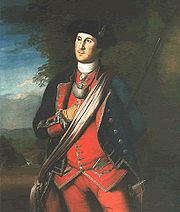
without being molested. These men were among a number of famous people who were in and out of Garrett County’s boundaries during Colonial days. In the mid-18th century, much of the land was surveyed by George Washington
for Lord Fairfax. In 1755, during the French and Indian War
, Washington guided General Edward Braddock
using Native American trails from Fort Cumberland
over the rugged mountains to Fort Duquesne
(Pittsburgh) where he was defeated by the French.
Since he was well acquainted with the frontier wilderness, Gist was the person selected to guide George Washington to Fort LeBoeuf on the upper reaches of the Allegheny River
. In 1753, Washington carried a letter from Virginia’s Governor Dinwiddie, demanding that the French leave the area since it was land claimed by the Colony of Virginia. They refused, and in 1754, he returned with a military force. Gist and Washington met at the Wills Creek trading post (Cumberland) and started westward. They camped one night at Little Meadows
on November 16, 1753, and again camped there on their return trip on January 5, 1754.
At this time Gist owned land near the present city of Uniontown, Pennsylvania
, which he called Gist’s Plantation and began to build a model town on his plantation
. After Washington’s defeat at Fort Necessity on July 3, 1754 all the buildings were burned by the French and Indians.
Gist, who also owned land in North Carolina
, returned to the area with part of that colony’s militia and join General Braddock’s forces in 1755. Young Daniel Boone
was in the group which accompanied Gist on this trip.
Later, in the summer of 1759, Christopher Gist journey to Williamsburg, Virginia
. He contracted smallpox
and died along the road between Williamsburg and Winchester, Virginia
.
, Yorkshire, England, Thomas Cresap came to Maryland when 15 years of age. Thomas Cresap was a large landholder and European American settler in the state of Maryland. He was known in Western Maryland
as a border ruffian
and in Pennsylvania as the "Maryland Monster". He settled in the eastern disputed territory between Maryland and Pennsylvania. He connived in the 1730s to expand the borders of Maryland at the expense of Pennsylvania and Virginia by settling German immigrants into disputed areas and surveying the source of the Potomac River as far south as possible. Only in 1746, with the arrival of Mason and Dixon from England, was this dispute finally resolved.
Cresap got into a quarrel with a Pennsylvania county sheriff, a deputy was mortally wounded in an exchange of gunfire, and Cresap spent eight months in a Philadelphia, Pennsylvania
jail, finally being released in the summer of 1737. In 1741 he arrived in Western Maryland (in what is now Allegany County) and established a trading post along an old Native American trail. A few miles east of present day Cumberland, the settlement was called Shawanese Old Town because it was the site of a Shawnee
village abandoned about a decade earlier. Today this area is known as Oldtown, Maryland
.
Like many trappers and explorers of his time, Thomas Cresap made trips westward through the Allegheny Mountains
and developed a number of friendships with the local Native Americans. As a result the Virginia Company
authorized him to lay out a pack horse trail westward from the Wills Creek trading post
(Cumberland) to Fort Redstone on the Monongahela River
in Brownsville, Pennsylvania
. He employed a local tribe of Native Americans to do the work under the direction of Nemacolin, a Delaware, (Lenape)
chief. It is one example of the gradual change of Native American Culture
, because they were working for wages. The pack horse path which they blazed and cleared in 1749 or 1750 became the famous Nemacolin's Path
, and roughly follows the present U.S. Route 40 in Maryland
. The path was of military importance as the route of George Washington's first Western expedition and the Braddock expedition
.
General Edward Braddock
had to depend on Thomas Cresap for many of his supplies during the 1755 Braddock expedition
. This was because the General did not receive the supplies he was supposed to have for his soldiers, due to poor communications with the various Colonies involved in the champain. Within 7 miles (11 km) of Fort Duquesne
Braddock was ambushed by a combination of French soldiers and Indian warriors and completely defeated. After the disastrous ambush by the French and Indians
and retreat of the Colonial forces, the Native Americans let loose a reign of terror on the European American settlers in the mountains.
Thomas Cresap organized a group of Rangers in the Spring of 1756. On June 30, 1756, the Rangers got into a skirmish with the Native Americans on the Braddock Road, several miles west of Little Meadows
. Legend says that Negro Mountain was named for a slave (a butler or valet; or possibly a scout or ranger) of Cresap’s, named Nemesis, who was killed in the skirmish. He is said to be buried on Negro Mountain were he died.
Thomas Cresap was also a driving force in the Ohio Company
, an enterprise that sought to open an important trade route to the west. Cresap engaged in a lengthy dispute with George Washington over property in the Ohio Valley. Cresap became totally blind a few years before his death in 1787. His name lives on in Cresaptown, Maryland
several miles southwest of Cumberland, Maryland
.
wilderness, especially in Garrett County and the surrounding regions of what is now West Virginia
. His woodland exploits were, by modern standards, phenomenal. His pursuit of the abundant white-tailed deer
, black bear
, panthers, wolves
and wild turkey
s through the western wilderness became legendary and there were many witnesses to his exploits in the forests. He was described by those who lived near him as "entirely free from vice"; honest and direct as any man could be and greatly respected. He had a reputation as the best hunter in the northwestern section of Maryland and celebrated as Maryland
's most famous frontier hunter.
First published in 1859, Browning's memoir, Forty-Four Years Of The Life Of A Hunter: Being Reminiscences Of Meshach Browning, A Maryland Hunter, is a half backwoods history, half heroic adventure story. It recounts his hunting expeditions and life-threatening encounters while stalking game and records details of life in early frontier America, western Maryland folkways and early settlement life.
was the path followed by some early European American settlers who came into Garrett County from the Virginia area.
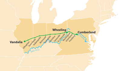 Intended to be known as the Cumberland Road, the new highway was soon termed the National Road because it was built with federal money. For half a century, passage westward from Cumberland by travelers and settlers was over the old Braddock Road, built by General Braddock’s troops during 1755.
In 1806, Thomas Jefferson
signed a bill from Congress setting aside money building the new road from Cumberland to Wheeling, West Virginia
. Work started in 1811 at Cumberland and by 1816, the Maryland section had been completed; two years later, it was completed all the way to Wheeling and the banks of the Ohio River
.
The old National Pike was built over this same trail in the northern part of Garrett County between 1811 and 1819. Some of the old stage coach inns can still be found in the Grantsville area from this by-gone era. Today's US 40 also follows much of the same path of the old National Pike.
, who in 1758 had been the champion of the Braddock road (not then supposed to lie in Pennsylvania) and who in 1784 sought a route located wholly in Virginia. Returning from a visit to his western lands, after following McCulloch's Path (then the most important route across the rugged ridges between the valleys), he crossed the North Branch Potomac River on the future route of the greater Virginia highway which was partially realized in the 'state road' authorized from Winchester via Romney
to Morgantown
before 1786, and extended westward in 1786 by a branch road from near Cheat
to Clarksburg
, from which the first road was marked to the mouth of the Little Kanawha River
between 1788 and 1790."
Unlike the National Road, the Northwestern Turnpike
was financed by the sale of bonds; most of them to residents of Virginia
. For many years a proposed route westward through Virginia had been considered. After Ohio
was admitted to the Union in 1803, the consideration intensified; then, as the years passed and Virginia merchants noted the increase in business and traffic over the National road, the Virginia Legislature decided to make the route westward a reality. A bill was passed authorizing the Northwestern Turnpike in 1827, surveys were begun, and Colonel Claudius Crozet
was appointed Chief Engineer to lay out the route of the road.
Beginning in Winchester, Virginia
, the new road reached Romney, West Virginia
in 1830, and by 1838, it had been completed all the way to Parkersburg, Virginia and the Ohio River. Northwestern Turnpike
crossed the North Branch Potomac River southwest of the present town of Gormania, West Virginia
and entered the southwest corner of Maryland through which it passed for 8.75 miles (14 km), crossing the Alleghenies and emerging into Preston County, West Virginia
east of the German settlement of Aurora, West Virginia
. Today, a portion of U.S. Route 50
follows the historic Northwestern Turnpike
and is known as the George Washing Highway.
During the night of November 12 – 13, 1833, one of the greatest meteor showers of modern history took place over North America. Although it was a nationwide event, the effects of the phenomena took different forms in Garrett County. The sky was luminous all night long and many people thought it was the end of the world. Groups huddled in prayer on village streets and church bell rang continuously, while calmer people tried to reason and assure everyone that it was simply the time of year when the earth entered the Leonids
meteor belt out in space.
One recorded episode of the Night Of The Stars is that of a sub-contractor on the Northwestern Turnpike. Customarily, he woke his men about 4 a.m. for breakfast preparation. When the 60 workmen saw the sky lit up with falling meteors, they concluded that it was the end of the world and immediately deserted their work to return home to be with their families.
Washington used another Indian Trail in the south of the County when he surveyed the area for Lord Fairfax of Virginia. This road later became the present-day US 50.
During the following years, other families moved into the Youghiogheny River watershed. Records indicate that these families followed a settlement pattern typical of the time. They would take up a parcel of land, be there for one generation, and then move onward to land in the mid-west.
served in the American Revolutionary War
as a surgeon and later as a secretary to George Washington. An early American statesman, he became active in Maryland politics; member of the Continental Congress
(1783–1785)); Maryland signer of the United States Constitution
; United States Secretary of War
in the Cabinet of Presidents Washington and Adams (1796–1800); and the namesake of Fort McHenry
in Baltimore, Maryland.
The community of McHenry, Maryland
is on part of the land purchased by James McHenry in 1808. The site of his house is submerged under the waters of Deep Creek Lake. It was located almost directly down hill from the historical marker located along U.S. Route 219
south of the town of McHenry.
The names Fort McHenry and Baltimore include another association with Garrett County; Francis Scott Key
and the "Star Spangled Banner". Francis Scott Key never got to Garrett County, but Mrs. Key, her daughter, and grandchildren began spending their summers in the county beginning in the 1850s. The last grandchild, Miss Frances Howard, died in 1959 and their summer home on Alder Street was razed in 1962.
James Drane added an addition to the cabin shortly after he arrived, giving the building a total of six rooms; three upstairs and three down. He moved to western Maryland from Prince George’s County, which was part of the Maryland tobacco belt. Seemingly, James Drane intended to turn Flowery Vale into a tobacco plantation. However, the climate of Garrett County proved unsuitable for growing tobacco, and he turned to normal farm crops.
The last owners of the house were members of the Heinrick Richter family who purchased it in 1856. They leased it to a number of people; the last family left in 1952. The Accident Cultural and Historical Society was formed in 1987, and one of its main projects was the restoration of the Drane house.
On Oct. 25, 1991, the A. J. Wiley Co. of Springs, Pennsylvania, began the restoration work and on September 24, 1994, dedication of the restored building took place during the Drane Family reunion. At that time, all the restoration work had been complete with the exception of rebuilding the chimney on the west end of the building; it was completed by June 30, 1995.
Shortly after World War I, timber cutting began in the Three Forks Run area. In 1924, the Chaffee Railroad Company was organized to build a standard gauge
railroad from Vindex to the Western Maryland Railroad downstream from Kitzmiller. Unfortunately, the lumber company business in Vindex only existed for a year or so after the standard gage railroad was built; however, Johnstown Coal and Coke Co. opened up an excellent seam of coal and Vindex flourished as a coal town. Finally, in 1950, the coal company went out of business, the mine closed, and Vindex became a ghost town. Today, only a few concrete steps and house foundations attest to the fact that a town once existed there.
In 1889, the Confluence and Oakland Railroad was extended up the Youghiogheny River 2 miles (3 km) beyond Friendsville to a new milling operation. Houses, a church, and a school followed in quick succession as work of the saw mill operation brought people into the area.
First, the Yough Manor Lumber Company built their saw mill there since it was cutting trees in the area; so the town was called Yough Manor. Next, came the A. Knabb Company which set up a stave mill in 1891. The company did this through negotiations with the Yough Manor people, and the town was renamed Krug after Mr. Henry Krug
, one of the Knabb officials. Finally, during the early 20th century, the Kendall Lumber Company took over the saw mill operation and the town received its third name, Kendall.
As the timber cutting began to diminish in the 1920s, mill buildings and houses were torn down. The McCullough Coal Mine Company was the final one to operate at the town’s location. When the tracks of the Confluence and Oakland Railroad were removed in the 1940s, the remaining houses and other buildings completely disappeared, and nothing is there today but old foundations and sawdust piles.
with all of the houses built on the same pattern. They were constructed beside a long street which follow the top of the bank of the Potomac River.
The mines in the Kitzmiller and Shallmar area slowed production to almost zero when the coal market slumped in the mid-1920s; eventually most of them went out of business during the Great Depression of the 1930s. Today, most of the company houses in Shallmar are privately owned and the old company store building is still there along with the Marshall house.
, who built a grist mill there in 1802. Years later, Ebinezar opened a woolen mill and the town was eventually given the name Kitzmillersville; later, it was shortened to Kitzmiller.
The town had a steady growth after the West Virginia Central and Pittsburgh Railroad was pushed up the Potomac River. First it was enlarged by timber cutting and later became a center for local coal mining. By 1908, there were four major coal mines in the Kitzmiller area, providing employment for hundreds of miners.
An interesting part of the mining operations was the aerial transport of coal across the river. As the railroad progressed up the river, sometimes it was easier to build the tracks on the West Virginia side; other times on the Maryland side. As a result, the railroad crossed and re-crossed the river several times. To get their coal to the railroad’s loading tipples, the management of the coal companies would use a cable car system, or construct a trestle high above the river.
One example of the cable car was the Hamill Coal and Coke mine downstream from Kitzmiller which transported its coal via a cable car system across the river to a tipple on the West Virginia side. Upstream above Kitzmiller, the Garrett County Coal Mining Company transported its coal across the river on a trestle.
with England were far beyond the boundaries of Garrett County. Nevertheless, Garrett County men were conscripted to serve in the Maryland Militia. The process of filling the conscription call is described in Meshach Browning
’s Forty Four Years The Life Of A Hunter beginning on page 180.
According to Browning, all men who had resided in the area for more than ten days were subject to be conscripted for service. The particular description of conscription process which he wrote about took place at Selbys Port, where 20 men were chosen. Eighteen were to be privates and they elected one of the two remaining men to be their Sergeant. From there, the men went to Cumberland to be incorporated into a larger group of soldiers. As near as can be determined, 49 men of Garrett County were veterans of the War of 1812.
reached Cumberland in November, 1842. Surprisingly, it produced and unexpected economic boom for both the National Road and the Northwestern Turnpike that it lasted for the next eleven years until the railroad got to Wheeling. The arrival of the railroad in Cumberland meant that the long haul over the roads to East Coast markets was cut in half. Livestock and merchandise flowed eastward to the railroad at Cumberland, and the same wagons were re-loaded with westbound merchandise.
This situation may have continued very pleasantly for many years, but the purpose for building the railroad in the first place was to reach the potential market of the Ohio River territory. Several years were spent tying to decided the best route to take over the mountains; finally, in 1848, the route which followed Crabtree Run of Garrett County was chosen and construction of the railroad was resumed.
In October 1851, the railroad passed through Oakland and on Christmas Eve 1853, it finally reached the banks of the Ohio River near Wheeling. During the years 1848–1853, over 5,000 men worked in the mountains to build the railroad. Baltimore and Ohio Railroad Station, Oakland
In 1884 the Baltimore and Ohio Railroad Station, Oakland was built to support the development of Oakland and Garrett County as a resort area. It is one of the finest remaining examples in Maryland of a Queen Anne style railroad station. It was listed on the National Register of Historic Places
in 1974.
and his brothers began timber cutting in the Potomac River
Valley. At first, they floated the logs down the river to a saw mill near Piedmont, West Virginia
. In 1881, Davis began pushing the West Virginia Central Railroad and Pittsburgh Railroad
up the river valley, with small branch lines running up the hollows of the tributaries of the river. As the railroad progressed up the river, Davis built additional saw mills at strategic locations along the railroad. The railroad crossed and re-crossed the river many times in its route to the headwaters of the river; thus, some saw mills were in West Virginia others in Maryland. Eventually, the railroad passed the springing point of the river and went all the way to the present city of Elkins, West Virginia
.
On November 1, 1905, the West Virginia Central Railroad and Pittsburgh Railroad
was sold to the Western Maryland Railway company.
. The movement took formal shape in 1833 when the American Anti-Slavery Society
was organized in Philadelphia. From that date onward, the abolitionists defied existing laws by assisting in the escape of run-away slaves headed northward. The Underground Railroad consisted of as many varied routes as there were people sympathetic to the plight of the slaves.
It is thought that two underground lines entered southwestern Pennsylvania. One crossed the Mason-Dixon Line
in southern Greene County, Pennsylvania
coming from Morgantown, West Virginia
where it branched with one fork going to Uniontown, Pennsylvania
. The other route that entered Pennsylvania came from Cumberland, via the National Road (today U.S. Route 40
) where slaves would be passed to Somerfield, Pennsylvania and on to Uniontown, Pennsylvania
.
Undoubtedly, there were safe houses or stations along the old National Road in Garrett County where runaway slaves could receive aid in their progress to freedom; unfortunately, no record of them exists. However, it is interesting to note that stations were clearly marked as a house that had a candle burning in one window, day and night, or a quilt hanging on a line in the back yard, so they may have existed along the National Road.
Maintaining a station was risky business in those days. In addition to supplying food and a hiding place for a runaway slave, operators of a station were subject to heavy fines and possible imprisonment under the Fugitive Slave Law of 1850
.
, it was also a border state, and men from Maryland served in both the Union Army
and the Confederate Army; Garrett County followed the same pattern as the rest of Maryland, having men who served on both sides of the conflict. However, although there was some rancor exhibited by a few Garrett County veterans, a number of men from both armies forgot their differences and joined the ranks of the local Maryland National Guard company.
Armed conflicts in the County were primarily in the form of raids by Confederate soldiers, known as McNeill's Rangers
, from the South Branch of the Potomac River area.
The largest raid on Garrett County took place on Sunday, April 26, 1863. The Rangers were divided into three different groups: one contingent burned the bridge over the North Branch Potomac River at Gorman, Maryland
and continued westward on the Northwestern Turnpike
; a second one headed for Altamont and destroyed railroad property there; and the third contingent came into Oakland about 11 o’clock in the morning.
In Oakland, the Rangers captured the local garrison of Union soldiers, burned the railroad bridge over the Youghiogheny River, as well as the highway bridge nearby; then departed for Terra Alta, West Virginia
.
Another raid took place in the eastern part of the county on May 5, 1864, when McNeills Rangers attempted to blow up the railroad bridge over the Potomac River at Bloomington, Maryland
. One group of Rangers went to work setting the explosives while a second group rode on to Piedmont and destroyed shop buildings and rolling stock of the railroad.
On learning that a large force of Union soldiers was on their way from Keyser, West Virginia
, to Piedmont, West Virginia
, the Rangers decided to blow up the bridge and leave. The explosives were set off, but after the dust and smoke disappeared, the bridge was still standing.
Melchior J. (Melkey) Miller was the native-born son of a German immigrant and farmer who arrived in the United States in the early 1830s, part of a great wave of German immigrants
looking for good land and opportunity. In 1875, Melkey Miller purchased a farm along a tributary of South Branch Bear Creek, just southeast of Accident, Maryland
. He also bought out the rather crude equipment of a small distillery from Joel Miller, in the Cove area of Garrett County, and moved it to his farm. Like many other distillery owners, Melky was not a distiller himself; he hired professionals to operate the business. His three sons, William, John, and Charles, learned the trade from these experts, eventually replacing them.
In 1902 Melchior sold the distillery to his sons. William continued as distiller, while John and Charles established a wholesale and retail whiskey business in nearby Westernport, Maryland
. The town was so named because it was the western most navigable port on the Potomac River
. Whiskey could be sent downstream by boat to Cumberland where it could either continue down the Chesapeake and Ohio Canal
to Washington or be carted by wagon over the National Road to Baltimore or later go by railroad. Reflecting the new owners, the company changed its name to M.J. Millers Sons Distillery. The boys had an evident genius for business and soon built Melky Miller’s Maryland Rye Whiskey into a highly respected local and regional brand. Although production was relatively small – only 29 bushels of grain processed daily according to Federal records – the quality of the company’s whiskey was high. The firm also was noted for the artistic design of both the jugs and the bottles in which it marketed its products.
The passage of the Volstead Act
in 1919 brought the family business to a close. In 1920 all of the bonded stock in the Accident warehouses was transferred to government concentration warehouse in Cumberland. The distillery itself was closed and left to decay. In Accident, Maryland
the foundations for the Bonded Warehouses of the distillery can still be seen 200 feet (61 m) south of the Miller Road, 0.25 miles (402.3 m) east of the Brethren Church Road intersection.
The Vacation development trend began in 1872, as resort hotels arose in the county’s southwest, where the Baltimore and Ohio Railroad
traversed the plateau after climbing out of the Potomac River Valley. The area was conveniently located a day’s train ride from Baltimore, Maryland and Washington, D.C.
to the east and Cincinnati, Ohio
to the west, encouraging overnight stays. Hotels were built next to the station and either privately owned or owned by the railroad. Hotels prospered as travelers who did not want to ride a train all night would stop and then resume their journey the next day.
Depots at Mountain Lake, Maryland
, Deer Park, Maryland
and Oakland, Maryland gave travelers easy access to hotels and brought the rich and famous of the day to the area for recreation and relaxation. Hotels
began catering to a wealthy urban clientele who enjoy the mountain climate, and would spend a week or so relaxing in the cool air of the station towns away from the cities.
Soon after the road was opened, a man named John Hays built a large house along it in the Green Glades area, and began to operated it as a tavern. Ownership of the building changed hands several time during the years that it existed. Around 1809, Henry Ingman, a son-in-law of one of the owners, took over the tavern operation. Although Ingman never owned the property, it was known as Ingman’s Tavern for a number of years.
The tavern was the center of activity in 1824 when a Potomac River Canal crew spent most of the summer in the area. They were trying to map a route to bring a canal over the mountains to connect with the waters of an Ohio River tributary. Visiting the crew while they stayed at Ingman’s Tavern was the famous John C. Calhoun, Secretary of War at the time.
Ingman’s Tavern was torn down in the 1890s, but some small trees in a field mark its general location along the Steiding Church Road.
at Grantsville
. It is a -story, Greek Revival
brick structure, built about 1842. It was built for Solomon Sterner to serve travelers on the National Road.
, a distinguished Union
officer during the American Civil War
. A large monument in the old Oakland Cemetery marks the burial site of John and Ann Rebecca Dailey.
Included among the guests at the Glades Hotel was Senator Jefferson Davis
. He was not well and spent three weeks at the hotel under the medical care of Dr. J. Lee McComas of Oakland. In successive years, the Glades Hotel was expanded until it was three times it’s original size and stretched almost 200 feet (61 m) beside the railroad tracks across from the Oakland station. Unfortunately, it caught fire and burned down in 1874 and set the station on fire as well. The hotel was rebuilt, slightly to the east of the station, and existed there until it was torn down in 1905; the site of the hotel is now part of the town’s parking lot.
 In 1858, John W. Garrett
became President of the Baltimore and Ohio Railroad
. He was not a stranger to western Maryland and had many acquaintances in the Oakland – Deer Park area. Among the people he knew and worked with was Henry G. Davis
; undoubtedly, it was Davis who promoted the idea of a hotel in the cool air of the mountain top.
Of course, the “resort hotel” idea did not develop in a vacuum because many of the East Coast railroads were finding that a lucrative passenger business could be built up by transporting people from a city to railroad-owned hotels in the mountains. Thus, the B.&O. Railroad ventured into the “resort hotel” business in 1869, when they purchased several 100 acres (404,686 m²) of Perry family’s “Anchorage Farm.” In 1872, the railroad built the center section of the Deer Park Hotel; and it opened for first time on July 4, 1873. The east and west wings of the hotel were added 1881-82 to provide the railroad with a hotel having 300 rooms.
According to tradition, The Anchorage house stood beside the present Pysell Crosscut Road; the location is marked by two sailing ship anchors on the lawn of a house that is there now.
During the early 1870s, H.G. Davis contracted to build a series of cottages on the hotel property, with the first one becoming John W. Garrett’s cottage. Later, this became the caretaker’s cottage, and Garrett had a more sumptuous summer home built to the west side of the hotel; he died there in the summer of 1884.
The railroads were responsible for building large summer resorts in the beautiful mountain areas in Garrett County. The rich and the famous were often found in Garrett County during this time period recreating. President Grover Cleveland
and his wife spent their honeymoon in 1886 at the Dear Park Resort
.
Known as the “cap stone” of the mountains, the hard Clarion sandstone forms much of the ridge of Backbone Mountain. In many places it is cracked and broken, producing large blocks which stand by themselves. One of the many such blocks along the mountain ridge is Eagle Rock. This massive block was accessible by horse and buggy for visitors from the Deer Park Hotel. It was a popular place to visit because of the tremendous views it afforded.
An interesting “first” is associated with both the Oakland Hotel and the Deer Park Hotel. The “first” has to do with the first telephone service put into use in Garrett County. Using the telegraph wires of the Baltimore and Ohio Railroad, telephone messages were transmitted between the lobby of the Oakland Hotel and the lobby of Deer Park Hotel. The service was inaugurated by none other than Alexander Graham Bell, himself.
Ruth Enlow Library; the old Geisman Hotel beside the wooden bridge over the railroad tracks on Third Street which is now an apartment house; and a hotel last known as “The Rest” on the corner of Seventh and Alder Streets which has also been turned into an apartment house.
One example of a summer home of well known people was the purchase of the Edwin Stabler house in Oakland in 1859 by Mrs. Francis Scott Key. (Stabler was the man who edited and published Meshach Browning’s book, “Forty Four Years The Life Of A Hunter.”) Mrs. Key enlarged the house and it was the summer home of her daughter and grandchildren, the Howard family of Baltimore. It was torn down in the 1960s after the last survivor of the family, Julia McHenry Howard, died in 1959.
Other houses built as summer homes are still in existence in Oakland and now occupied all year ‘round. One excellent example is Crook’s Crest; built as a summer home for General Crook on the top of a hill that overlooks the entire town, it is now the summer and winter home of Dr. Thomas Johnson.
type programs.
In 1882, the Mountain Lake Park Association built a large administration building later known as the Assembly Hall. Ten small summer cottages were quickly constructed, and the town of Mountain Lake Park came into existence. Within the next five or six year a large number of summer homes had been constructed, increasing in size each year. By 1895. the Mountain Chautauqua at Mountain Lake Park was a huge success, with hundreds of people attending the many programs offered.
To accommodate visitors who only wanted to be in Mountain Lake Park for a week or two, many small hotels sprang up throughout the town. Today, some of these large Victorian type buildings are still standing and have become private homes.
Largest of all the hotels built in Mt. Lake Park was the Mt. Lake Park Hotel. It was built in two stages; a large 3-story section in 1898, and a long 2-story addition built in 1902. It gradually became a center for many social activities in Mt. Lake Park until the beginning of World War II. Then, declining business forced its closure in the 1950s, and it was finally razed in 1963.
The Bashford Amphitheater was begun in 1899 and completed in 1900. This auditorium with its huge umbrella shaped roof had a seating capacity of 5,000 and was often filled to capacity by speakers of National reputation. In 1911, when William H. Taft spoke there, a crowd, estimated at 7,000 people, gathered under its roof to see and hear the President of the United States. In 1946 it was torn down for the lumber, because it was too expensive to maintain.
Today, only the ticket booth for the amphitheater remains to testify of this unusual building’s existence.
Although it was included in the name of the Mt. Lake Park Association, a lake did not exist there for a number of years. As a matter of fact, it was almost 15 years after the founding of Mt. Lake Park that an artificial lake was finally constructed in meadow land on the eastern side of town. Although it became a popular spot for summer recreation with swimming and boating one of its design features was to provide hydro-electric power to light the Association’s Assembly Hall and Bashford Amphitheater.
During the winter months, ice was cut from the surface of the lake and stored in a large shed with a capacity to hold a reported 2,500 tons of ice. A railroad siding to the B. & O. Railroad served for transporting large shipments of ice from the lake. At one time the lake covered 22 acres (89,030.9 m²) and stretched all the way to Crystal Spring, 500 yards from the breast; now, it is the size of a farm pond.
It boasted a gambling casino, bars, dancing, and a host of other recreation attractions. So completely different was it from the hotels and summer homes in Mountain Lake Park, that the saying soon developed, “If you want to sin … … go to Loch Lynn!”
The large Loch Lynn Hotel burned down one September evening in 1915. The swimming pool building existed until 1986, when it was torn down for the lumber.
. Though the situation in Garrett County forests typified central and northern Appalachia in 1900, singular individuals and events brought about significant change over the next century.
In 1906 Robert and John Garrett, principal officers in the Baltimore and Ohio Railroad
, gave the State of Maryland 2000 acres (8.1 km²) of forest land, including parcels of virgin hemlock forests, on condition that a Maryland Forestry Department
be established. The state legislature, spurred by Senators William McCulloh Brown and General Joseph B. Seth, with the aid of State Geologist W. Bullock Clark, responded with Maryland’s first forestry law, which Governor Edwin Warfield
signed into law on April 5, 1906. Thus establishing a statewide forestry program and forest conservation initiative, from which emerged almost immediately Maryland’s system of state parks.
The law established a Board of Forestry, made up of influential Marylanders, to oversee the management of the Garrett bequest, to institute a statewide program of forest conservation, to accept additional land donations, and to hire a state forester. Acting upon the board’s recommendation, Governor Warfield appointed an able young forester working for the U.S. Forest Service, Fred W. Besley, who would serve as Maryland’s first State Forester from 1906 until 1942. A Yale School of Forestry trained protégé of Gifford Pinchot
, first U.S. Forester, Besley proved to be an able and energetic choice.
Besley realized almost immediately that one good way to promote the forestry agenda was to encourage the public to use forest reserves for recreational purposes. Besley set priorities in four areas: fire control, forest inventory, public land management, and private landowner assistance.
The Great Depression
of the 1930s, as devastating as it was to the nation as a whole, proved a boon to forest and park development. One of President Franklin D. Roosevelt
’s New Deal
programs was the Civilian Conservation Corps
, which, in Maryland, put 30,000 young unemployed men to work reclaiming forest and other natural resources, building recreational facilities and restoring historic structures on public lands. Most of the recreational facilities that the CCC built in Maryland forests and parks are in use today.
A legacy of tourism and recreational land use begun in the late 19th century continues to evolve. Today, Maryland's system of state forests and parks controls over 70,000 acres of forest land in Garrett County. Both Marylanders and visitors enjoy a precious outdoor resource thanks to the farsightedness of Fred Besley and the many other dedicated forest and park professionals over the past century.
overcame the slump in recreation produced by the development of travel by automobile rather than passenger train; it was this slump caused the demise of the “great hotels.” During the 1930s, more and more out-of-state license plates appeared on automobiles traveling the highways around the Lake.
Then in 1937-38, the Rural Electrification Commission extended electric lines all around the Lake and the building of cottages leaped forward. Gradually, after World War II, summer cottages were “winterized” or rebuilt for winter recreation.
Today, Deep Creek Lake area is both a winter and summer resort, and with the development of “year-round” State Park facilities, recreation in Garrett County is at an “all-time” high.
Bear Creek grist mills
One of the first grist mills built on Bear Creek was the Engle Mill, built by Samuel Engle in 1835. Although the mill disappeared long ago, the millrace can still be seen along the bank above the mill’s location.
Samuel Engle had an energetic young man working for him named Henry Kaese. As the community grew larger, and there was more milling business to be done, Henry Kaese built a grist mill 0.5 miles (804.7 m) downstream from the Engle mill in 1868. According to Kaese family tradition, Mrs. Kaese supervised the digging of the millrace while her husband, Henry Kaese, worked with the men to build the grist mill. Over the years, Henry Kaese and later his son, Henry Kaese Jr., upgraded the mill from using mill stones to the “roller mill” system. The roller mill system operated like the old washing machine ringer.
Kaese’s mill still has all of its machinery inside, and the iron water wheel is one of the few remaining ones in western Maryland.
At first, the farmers would “burn” their own lime in the field where it was to be used. They would stack fire wood in a symmetrical pattern, cover it with lime rock, and pile dirt over top of the wood and stone. Then, the whole thing would be set on fire and the heat of the burning fire wood caused the lime stones to disintegrate into slake lime; the “burning” took about three weeks to accomplish.
Enterprising men realized that using a furnace called a lime kiln was a quicker and easier way to produce slaked lime all year ‘round. As a result, lime kilns appeared at various parts of the County where there were limestone outcroppings. Although it is no longer used, one kiln still exists on the Hoyes Run Road.
, Jesse Tomlinson built a sawmill around 1815. Water-powered, these mills were located near stands of white pine and within about 2 miles (3 km) of the National Pike . At first, white pine was the only species harvested.
Both timber production and land clearing rates ratcheted upward with the advent of steam technology and improving transportation. The first steam saw mill in Garrett County was built in 1837 ... on the Red Run, 2 miles (3 km) above the National Road
. In three years it depleted 250 acres (1 km²) of white pine. The National Road itself, funded by Congress in 1806 and completed to Wheeling, Virginia, in 1818, provided improved means to transport sawn lumber and agricultural products. It also served as a vector for increased settlement pressure as immigrants swarmed through the region into the Ohio Valley during the early-to-mid-19th century.
At mid-century the B&O Railroad penetrated the county, augmented by a network of narrow gauge rail lines that quickly accessed once remote timber. Cumberland, 15 miles (24 km) to the east, was Maryland’s second largest city in 1840. Mount Savage, just down the mountain from Garrett County, emerged as a thriving iron center. When mining interests began extracting anthracite coal from seams in the Georges Creek and Wills Creek Valleys, also to the east, demand for wood and agricultural commodities exploded. The regional growth of
tanneries depleted hemlocks, literally stripping the forest bare and typically leaving the wood to rot. Altogether, through the 19th century land clearing in Garrett County averaged about 2.5 square miles (6 km²) per year.
John W. Garrett turned out to be a civilian hero during the American Civil War because he kept the Baltimore and Ohio Railroad running in spite of the Confederate soldier’s destruction of bridges and tracks. However, Garrett was supported by an able supplier of bridge timbers and cross ties, Henry Gassaway Davis, one of the first large-scale timber operators in Garrett County.
Henry G. Davis built a tramroad from Deer Park to the present Deep Creek Lake area. He had a large saw mill in the Thayerville area. The Davis tramroad followed the general route of the Deer Park – Sand Flat Road; faint traces of its existence can still be found in some places.
Davis was soon followed by a number of timber cutting operators and the Garrett County forests with their giant oak, chestnut, and evergreen trees began to disappear. Meadow Mountain Lumber Company was one of the largest timber operations in the north central part of the County; Kendall Lumber company cut trees in the southern part; and Savage River valley had several large companies which cut trees in that area.
The saw mill continued in operation until it closed in 1918. At the same time the saw mill was built, Jennings Brothers began construction of a railroad to follow the Casselman River to the community of Jennings. It began as an extension of the B. & O. Railroad’s Salisbury branch line. Although the mill closed in 1918, the railroad continued to operate under different names until 1959, when it was abandoned and the rails removed.
Today, the Mettiki Coal Mine on Backbone Mountain is the major producer of coal in Garrett County. When operating at peak production, the company is capable of digging 20, 000 tons of coal per day; exceeding the total out-put of coal for the County’s mines in 1900.
Although nothing remains of the iron furnace today, the nearby quarry which supplied some of the iron ore is still there.
A law of physics states that stored gas released from higher pressure, takes up heat. Thus, the gas lines from the wells must have some anti-freeze injected into the pipes to prevent them from freezing-up at the “well head” during cold weather.
The reason for abandoning the hydro-electric dream was the increase efficiency of steam driven electric plants and long distance high-voltage electric transmission. (The steam powered electric plant near Mt. Storm, W.Va., is an excellent example of an efficient generating plant and long distance high-voltage electric transmission.)
Charles I of England
Charles I was King of England, King of Scotland, and King of Ireland from 27 March 1625 until his execution in 1649. Charles engaged in a struggle for power with the Parliament of England, attempting to obtain royal revenue whilst Parliament sought to curb his Royal prerogative which Charles...
granted a charter that lead to the creation of the Province of Maryland
Province of Maryland
The Province of Maryland was an English and later British colony in North America that existed from 1632 until 1776, when it joined the other twelve of the Thirteen Colonies in rebellion against Great Britain and became the U.S...
, a proprietary colony
Proprietary colony
A proprietary colony was a colony in which one or more individuals, usually land owners, remaining subject to their parent state's sanctions, retained rights that are today regarded as the privilege of the state, and in all cases eventually became so....
. In 1696, the western part of the Province of Maryland, including the present Garrett County, was incorporated into Prince George's County
Prince George's County, Maryland
Prince George's County is a county located in the U.S. state of Maryland, immediately north, east, and south of Washington, DC. As of 2010, it has a population of 863,420 and is the wealthiest African-American majority county in the nation....
. This county included six current State of Maryland counties, and by repeated splitting, new ones were created:
- Frederick County, MarylandFrederick County, MarylandFrederick County is a county located in the western part of the U.S. state of Maryland, bordering the southern border of Pennsylvania and the northeastern border of Virginia. As of the 2010 Census, the population was 233,385....
from Prince George's in 1748; - Montgomery County, MarylandMontgomery County, MarylandMontgomery County is a county in the U.S. state of Maryland, situated just to the north of Washington, D.C., and southwest of the city of Baltimore. It is one of the most affluent counties in the United States, and has the highest percentage of residents over 25 years of age who hold post-graduate...
and Washington County, MarylandWashington County, MarylandWashington County is a county located in the western part of the U.S. state of Maryland, bordering southern Pennsylvania to the north, northern Virginia to the south, and the Eastern Panhandle of West Virginia to the south and west. As of the 2010 Census, its population is 147,430...
from Frederick County in 1776; - Allegany County, MarylandAllegany County, MarylandAllegany County is a county located in the northwestern part of the US state of Maryland. It is part of the Cumberland, MD-WV Metropolitan Statistical Area. As of 2010, the population was 75,087. Its county seat is Cumberland...
from Washington County in 1789.
In 1872, Garrett County was formed from the western sections of Allegany County and has the distinction of being the last county created within the state of Maryland
Maryland
Maryland is a U.S. state located in the Mid Atlantic region of the United States, bordering Virginia, West Virginia, and the District of Columbia to its south and west; Pennsylvania to its north; and Delaware to its east...
.
Formation
When the Baltimore and Ohio RailroadBaltimore and Ohio Railroad
The Baltimore and Ohio Railroad was one of the oldest railroads in the United States and the first common carrier railroad. It came into being mostly because the city of Baltimore wanted to compete with the newly constructed Erie Canal and another canal being proposed by Pennsylvania, which...
came through the area in 1851 the people began to take a different look at the natural resources. The railroad's arrival meant access to East Coast markets and eventually to nationwide markets. Towns grew and citizens became more prosperous, and with the new prosperity came questions about taxation and representation, as well as appropriations.
Local grumbling about lack of representation resembled the cry of 1776, "No taxation without representation
No taxation without representation
"No taxation without representation" is a slogan originating during the 1750s and 1760s that summarized a primary grievance of the British colonists in the Thirteen Colonies, which was one of the major causes of the American Revolution...
!". Many prominent citizens could see beyond Cumberland
Cumberland, Maryland
Cumberland is a city in the far western, Appalachian portion of Maryland, United States. It is the county seat of Allegany County, and the primary city of the Cumberland, MD-WV Metropolitan Statistical Area. At the 2010 census, the city had a population of 20,859, and the metropolitan area had a...
, the Allegany County
Allegany County, Maryland
Allegany County is a county located in the northwestern part of the US state of Maryland. It is part of the Cumberland, MD-WV Metropolitan Statistical Area. As of 2010, the population was 75,087. Its county seat is Cumberland...
seat of government, to Annapolis
Annapolis, Maryland
Annapolis is the capital of the U.S. state of Maryland, as well as the county seat of Anne Arundel County. It had a population of 38,394 at the 2010 census and is situated on the Chesapeake Bay at the mouth of the Severn River, south of Baltimore and about east of Washington, D.C. Annapolis is...
, the State Capital, and the fact that men from Cumberland dominated as the Western Maryland
Western Maryland
Western Maryland is the portion of the U.S. state of Maryland that consists of Frederick, Washington, Allegany, and Garrett counties. The region is bounded by the Mason-Dixon line to the north, Preston County, West Virginia to the west, and the Potomac River to the south. There is dispute over the...
representatives in the Maryland Legislature.
Around 1870, a movement to form a new county became active under the leadership of Patrick Hamill
Patrick Hamill
Patrick Hamill was a U.S. Congressman from the fourth district of Maryland, serving one term from 1869—1871....
and Colonel James M. Schley. They wanted a county, separate from Allegany County, to include all the land west of Big Savage Mountain. They formed a committee in 1871 and presented a petition to the Maryland General Assembly
Maryland General Assembly
The Maryland General Assembly is the state legislature of the U.S. state of Maryland. It is a bicameral body. The upper chamber, the Maryland State Senate, has 47 representatives and the lower chamber, the Maryland House of Delegates, has 141 representatives...
for the division of Allegany to form a new county; two possible names for the proposed county were, Glades and Garrett.
Once more, as in 1776, printed matter helped to solidify public opinion. In August 1871, E.S. Zevely of Oakland
Oakland, Maryland
Oakland is a town in the west-central part of Garrett County, Maryland, United States. With a population of 1,925 according to United States Census 2010 figures, it is the most populated community in Garrett County...
began the publication of a weekly newspaper called the Glades Star. He selected "Work For The New County" as a slogan for his paper. Among other things in his editorials, he pointed out the fact that residents of the Districts of Allegany County to be included in proposed new county paid $28,000 in taxes under the existing Allegany County tax levy, but received less than $19,000 per year in appropriations
Appropriation (law)
In law and government, appropriation is the act of setting apart something for its application to a particular usage, to the exclusion of all other uses....
.
Of course, Zevely's weekly editorials stirred protest in the Cumberland area, and the Cumberland News once printed a terse statement saying, "It is like jumping from the frying pan into the fire, and we think the mountaineers had better stay in the pan."
In January 1872, a number of residents from the western portion of Allegany County sent a petition to the state legislature requesting the creation of the new county. Advocates of the new county cited as their main reason for this initiative:
On April 1, 1872 the Maryland State Legislature, acting in compliance with this petition, approved an act (Chapter 212, Acts of 1872) providing for a public vote. It was a constitutional requirement that the final ratification of the county’s creation be left up to the qualified voters of the territory. The date for the voting was set for November 4, 1872. During the summer and early fall of 1872 a vigorous campaign was conducted for the formation of a new county.
The question concerning the creation of a new county, as well as the people’s choice for county seat, were both voted on in the November 4, 1872 general election
General election
In a parliamentary political system, a general election is an election in which all or most members of a given political body are chosen. The term is usually used to refer to elections held for a nation's primary legislative body, as distinguished from by-elections and local elections.The term...
. Voters overwhelmingly approved creation of the new county by a vote of 1297 to 405. The popular choice of the electorate for the county seat was Oakland, which won out over rivals Grantsville
Grantsville, Maryland
Grantsville is a town in Garrett County, Maryland, United States. The population was 619 at the 2000 census.-History:Grantsville, 1/2 mile west of the Casselman River, began as a small Amish and Mennonite settlement, called Tomlinson's or Little Crossing, along Braddock rd., which wound westward...
and McHenry’s Glades
McHenry, Maryland
McHenry is a small community located in Garrett County, Maryland on the northern most shore of Deep Creek Lake.Located on the outskirts of McHenry is the Garrett County Airport, Wisp Ski Resort, and Golf Club at Wisp....
, the former by only 63 votes. On December 4, 1872, Maryland governor William Pinkney Whyte
William Pinkney Whyte
William Pinkney Whyte , a member of the United States Democratic Party, was a politician who served the State of Maryland as a State Delegate, the State Comptroller, a United States Senator, the 35th Governor, the Mayor of Baltimore, Maryland, and the State Attorney General.-Early life and...
proclaimed that the extreme western triangle of the state “has become and is now constituted as a new county, to be called ‘Garrett County.’” In 1880, the first Garrett County census showed a population of 12,175 people.
The county was named for John Work Garrett
John W. Garrett
John Work Garrett was an American banker, philanthropist, and president of the Baltimore and Ohio Railroad ....
(1820–1884), railroad executive, industrialist, and financier. Garrett served as president of the Baltimore and Ohio Railroad
Baltimore and Ohio Railroad
The Baltimore and Ohio Railroad was one of the oldest railroads in the United States and the first common carrier railroad. It came into being mostly because the city of Baltimore wanted to compete with the newly constructed Erie Canal and another canal being proposed by Pennsylvania, which...
from 1858 until his death in 1884. Garrett County was formed from the western sections of Allegany County and has the distinction of being the last county created within the state of Maryland.
Indigenous peoples of the Americas
Indigenous peoples of the Americas
The indigenous peoples of the Americas are the pre-Columbian inhabitants of North and South America, their descendants and other ethnic groups who are identified with those peoples. Indigenous peoples are known in Canada as Aboriginal peoples, and in the United States as Native Americans...
criss-crossed Garrett County when locations of their trails are drawn on a map. Presumably, the trails which the Native Americans followed may originally been the seasonal migration paths of American Bison
American Bison
The American bison , also commonly known as the American buffalo, is a North American species of bison that once roamed the grasslands of North America in massive herds...
and elk
Elk
The Elk is the large deer, also called Cervus canadensis or wapiti, of North America and eastern Asia.Elk may also refer to:Other antlered mammals:...
herds. The trails gave the Native Americans
Native Americans in the United States
Native Americans in the United States are the indigenous peoples in North America within the boundaries of the present-day continental United States, parts of Alaska, and the island state of Hawaii. They are composed of numerous, distinct tribes, states, and ethnic groups, many of which survive as...
access to camping and trading sites during the warm months, and a route home to their permanent towns at the end of the summer season.
As near as can be determined, Native Americans came into the Garrett County area from two general locations: the Monongahela
Monongahela River
The Monongahela River is a river on the Allegheny Plateau in north-central West Virginia and southwestern Pennsylvania in the United States...
–Ohio River
Ohio River
The Ohio River is the largest tributary, by volume, of the Mississippi River. At the confluence, the Ohio is even bigger than the Mississippi and, thus, is hydrologically the main stream of the whole river system, including the Allegheny River further upstream...
drainage area to the west, and the New Creek
New Creek
New Creek is an stream in eastern West Virginia in the United States. It is the third major West Virginia tributary to the North Branch Potomac River. Via the Potomac, it is part of the watershed of Chesapeake Bay.-Course:...
–Potomac River
Potomac River
The Potomac River flows into the Chesapeake Bay, located along the mid-Atlantic coast of the United States. The river is approximately long, with a drainage area of about 14,700 square miles...
drainage area to the east. Evidence uncovered by floods in the Potomac River valley indicate some towns have been in existence for over 2,000 years.
Mound building, a phase of Native American culture
Indigenous peoples of the Americas
The indigenous peoples of the Americas are the pre-Columbian inhabitants of North and South America, their descendants and other ethnic groups who are identified with those peoples. Indigenous peoples are known in Canada as Aboriginal peoples, and in the United States as Native Americans...
that took place in other parts of eastern North America, seems to be absent in this area. However, archaeologists speculate about the natural trenches which George Washington
George Washington
George Washington was the dominant military and political leader of the new United States of America from 1775 to 1799. He led the American victory over Great Britain in the American Revolutionary War as commander-in-chief of the Continental Army from 1775 to 1783, and presided over the writing of...
used at Fort Necessity, and the embankments of Fort Redstone at Brownsville, Pennsylvania
Brownsville, Pennsylvania
Brownsville is a borough in Fayette County, Pennsylvania, United States, officially founded in 1785 located 35 miles south of Pittsburgh along the Monongahela River...
, as possibility being a phase of the mound culture.
During the Early Woodland period
Woodland period
The Woodland period of North American pre-Columbian cultures was from roughly 1000 BCE to 1000 CE in the eastern part of North America. The term "Woodland Period" was introduced in the 1930s as a generic header for prehistoric sites falling between the Archaic hunter-gatherers and the...
of Native American culture, several Shelter cave sites were occupied by the Native Americans. In 1950, a shelter cave north of Friendsville, Maryland
Friendsville, Maryland
Friendsville is a town in Garrett County, Maryland, United States. The population was 539 at the 2000 census.-Geography:Friendsville is located at ....
was excavated by an archaeological team from Carnegie Museum, Pittsburgh, Pennsylvania
Pittsburgh, Pennsylvania
Pittsburgh is the second-largest city in the US Commonwealth of Pennsylvania and the county seat of Allegheny County. Regionally, it anchors the largest urban area of Appalachia and the Ohio River Valley, and nationally, it is the 22nd-largest urban area in the United States...
. Known as Indian Rocks the cave is located near the headwaters of Laurel Run
Laurel Run (Georges Creek)
Laurel Run is a tributary stream of Georges Creek in Allegany County, Maryland. The creek rises about northwest of Lonaconing and empties into Georges Creek north of Barton.-References:...
. It yielded a variety of stone and ceramic artifacts, including one piece of pottery that was one of the oldest ones ever found in this area; possibly dating back to the Archaic Indian period making it up to 2,500 years old. Other Pre-Columbian era
Pre-Columbian era
The pre-Columbian era incorporates all period subdivisions in the history and prehistory of the Americas before the appearance of significant European influences on the American continents, spanning the time of the original settlement in the Upper Paleolithic period to European colonization during...
pottery in the cave indicated that it had been occupied continuously for almost 1600 years.
Native American cultural
Indigenous peoples of the Americas
The indigenous peoples of the Americas are the pre-Columbian inhabitants of North and South America, their descendants and other ethnic groups who are identified with those peoples. Indigenous peoples are known in Canada as Aboriginal peoples, and in the United States as Native Americans...
artifacts of the Cherokee
Cherokee
The Cherokee are a Native American people historically settled in the Southeastern United States . Linguistically, they are part of the Iroquoian language family...
, Delaware (Lenape)
Lenape
The Lenape are an Algonquian group of Native Americans of the Northeastern Woodlands. They are also called Delaware Indians. As a result of the American Revolutionary War and later Indian removals from the eastern United States, today the main groups live in Canada, where they are enrolled in the...
, and Shawnee
Shawnee
The Shawnee, Shaawanwaki, Shaawanooki and Shaawanowi lenaweeki, are an Algonquian-speaking people native to North America. Historically they inhabited the areas of Ohio, Virginia, West Virginia, Western Maryland, Kentucky, Indiana, and Pennsylvania...
can be found throughout Garrett County. Evidence shows that the indigenous Mingo
Mingo
The Mingo are an Iroquoian group of Native Americans made up of peoples who migrated west to the Ohio Country in the mid-eighteenth century. Anglo-Americans called these migrants mingos, a corruption of mingwe, an Eastern Algonquian name for Iroquoian-language groups in general. Mingos have also...
tribe seems to be the one which returned to the mountain top each year to hunt, fish, trade, and plant crops where open land was available. Northeast of Deep Creek Lake State Park, not far from the present day intersection of Rock Lodge and Mosser roads, on land belonging to the Nature Conservancy, can be found isolated boulders containing flint
Flint
Flint is a hard, sedimentary cryptocrystalline form of the mineral quartz, categorized as a variety of chert. It occurs chiefly as nodules and masses in sedimentary rocks, such as chalks and limestones. Inside the nodule, flint is usually dark grey, black, green, white, or brown in colour, and...
. It was a source for flint arrowheads when the Native Americans came to spend the summers in what is now Garrett County.
Little Meadows, Maryland
One of the camping places along Native American paths during the Colonial period was Little Meadows, MarylandLittle Meadows, Maryland
Little Meadows is located at the foot of Meadow Mountain in western Maryland. It was a common stopping point for British troops during the French and Indian War and was frequented by George Washington.- George Washington and Little Meadows :...
. It was frequented by George Washington
George Washington
George Washington was the dominant military and political leader of the new United States of America from 1775 to 1799. He led the American victory over Great Britain in the American Revolutionary War as commander-in-chief of the Continental Army from 1775 to 1783, and presided over the writing of...
as well as many notable Trappers, explorers, and travelers who were in and out of the County’s boundaries during this time. A common stopping point for British troops during the French and Indian War
French and Indian War
The French and Indian War is the common American name for the war between Great Britain and France in North America from 1754 to 1763. In 1756, the war erupted into the world-wide conflict known as the Seven Years' War and thus came to be regarded as the North American theater of that war...
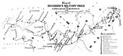
it is also a burial site for Colonial soldiers. General Edward Braddock
Edward Braddock
General Edward Braddock was a British soldier and commander-in-chief for the 13 colonies during the actions at the start of the French and Indian War...
made this site one of the many camps he established during his ill-fated campaign against Fort Duquesne
Fort Duquesne
Fort Duquesne was a fort established by the French in 1754, at the junction of the Allegheny and Monongahela rivers in what is now downtown Pittsburgh in the state of Pennsylvania....
. East of present day Grantsville, it is an easily accessible place to visit and remains of the Braddock Road can still be found there.
Seneca Trail – Hoop Pole Ridge Road
There were several north-south trails in Garrett County which were later developed into roads. The Hoop Pole Ridge Road ran from Oakland to Grantsville and followed part of the Seneca Trail. Traces of this old road can still be found at various places between Oakland and Deep Creek Lake, MarylandDeep Creek Lake, Maryland
Deep Creek Lake State Park is a popular vacation area in Garrett County, Maryland, USA. It surrounds a reservoir that was created by the construction of the Deep Creek Dam in 1923 by the Pennsylvania Electric Company on a tributary of the Youghiogheny River. The lake was purchased by the state of...
.
Glades Path – State Road to Bloomington
An Indian trail called the "Glades Path" came over Backbone MountainBackbone Mountain
Backbone Mountain is a ridge of the Allegheny Mountains of the central Appalachian Mountain Range. It is situated in the U.S. states of West Virginia and Maryland and forms a portion of the Eastern Continental Divide...
from the North Branch of the Potomac River near Bloomington, Maryland
Bloomington, Maryland
Bloomington is an unincorporated town at the confluence of the North Branch Potomac River and Savage River in southeastern Garrett County, Maryland...
and ended at the Little Youghiogheny River
Youghiogheny River
The Youghiogheny River , or the Yough for short, is a tributary of the Monongahela River in the U.S. states of West Virginia, Maryland, and Pennsylvania...
west of Oakland. In 1789, much of it became the route for the Oakland - Deer Park – Swanton – Bloomington Road.
Colonial Maryland and westward expansion
European American
A European American is a citizen or resident of the United States who has origins in any of the original peoples of Europe...
settlers to move into the wilderness and endure the hardships of such an undertaking?” The answer can be summarized in one word, “land.” The desire for land of their own, coupled with religious freedom, was the force that motivated the early European American settlers to leave their homes in Europe and settle in Colonial North America. In the 17th century, land was settled around the sea ports of the East Coast. Then, the westward movement began and the frontier was gradually pushed back through the mountains.
Through the 1609 charter from the King of England, to the London Company
London Company
The London Company was an English joint stock company established by royal charter by James I of England on April 10, 1606 with the purpose of establishing colonial settlements in North America.The territory granted to the London Company included the coast of North America from the 34th parallel ...
, the Colony of Virginia claimed all the land west of Laurel Mountain
Laurel Mountain
Laurel Mountain may refer to:*Laurel Mountain , in the Forbes State Forest of Pennsylvania**Laurel Mountain, Pennsylvania, a borough near the Pennsylvania mountain**Laurel Mountain Ski Resort, Pennsylvania...
to the Ohio River
Ohio River
The Ohio River is the largest tributary, by volume, of the Mississippi River. At the confluence, the Ohio is even bigger than the Mississippi and, thus, is hydrologically the main stream of the whole river system, including the Allegheny River further upstream...
as belonging to the Colony of Virginia.
The Fairfax Stone
One of the benefactors of the land grants of Virginia from the King of England was Thomas Fairfax, 6th Lord Fairfax of CameronThomas Fairfax, 6th Lord Fairfax of Cameron
Thomas Fairfax, 6th Lord Fairfax of Cameron was the son of Thomas Fairfax, 5th Lord Fairfax of Cameron and of Catherine, daughter of Thomas Culpeper, 2nd Baron Culpeper of Thoresway....
. In 1736, he employed Benjamin Winslow to prepare a map of the Potomac River
Potomac River
The Potomac River flows into the Chesapeake Bay, located along the mid-Atlantic coast of the United States. The river is approximately long, with a drainage area of about 14,700 square miles...
and to locate the springing point of the North Branch of the Potomac River. It was needed to mark the extreme western edge of the Northern Neck
Northern Neck
The Northern Neck is the northernmost of three peninsulas on the western shore of the Chesapeake Bay in the Commonwealth of Virginia. This peninsula is bounded by the Potomac River on the north and the Rappahannock River on the south. It encompasses the following Virginia counties: Lancaster,...
in the Virginia Colony that had been granted to Lord Fairfax by King Charles II of England
Charles II of England
Charles II was monarch of the three kingdoms of England, Scotland, and Ireland.Charles II's father, King Charles I, was executed at Whitehall on 30 January 1649, at the climax of the English Civil War...
. Winslow eventually came into the Garrett County area and located what he considered to be the westernmost springing point marking the beginning of the Potomac River
Potomac River
The Potomac River flows into the Chesapeake Bay, located along the mid-Atlantic coast of the United States. The river is approximately long, with a drainage area of about 14,700 square miles...
. He marked the location with a pile of rock and blazed trees. This is the location of the present Fairfax Stone
Fairfax Stone
Fairfax Stone Historical Monument State Park is a West Virginia state park commemorating the Fairfax Stone, a surveyor's marker and boundary stone at the source of the North Branch of the Potomac River in West Virginia...
.
Ten years later, in 1746, a second group of surveyors found the location identified by Winslow. Included in the surveying party was Peter Jefferson
Peter Jefferson
Peter Jefferson was the father of American President Thomas Jefferson . A surveyor and cartographer, his Fry-Jefferson Map of 1751 accurately depicted the Allegheny Mountains for the first time and showed the route of "The Great Road from the Yadkin River thro Virginia to Philadelphia distant 455...
, father of Thomas Jefferson
Thomas Jefferson
Thomas Jefferson was the principal author of the United States Declaration of Independence and the Statute of Virginia for Religious Freedom , the third President of the United States and founder of the University of Virginia...
. Included in the collection of photographs taken by W.E. Shirer in the early 1890s, is one which is an earlier photograph of the original Fairfax Stone monument. It is one of the vary few surviving photographs of the monument that was erected on October 17, 1746 by a survey party seeking the “springing point” of the Potomac River.
The Fairfax Stone location became a popular picnic spot after the West Virginia Central Railroad completed its rail line along the Potomac River and on to Elkins, West Virginia
Elkins, West Virginia
Elkins is a city in Randolph County, West Virginia, United States. The community was incorporated in 1890 and named in honor of Stephen Benton Elkins , a U.S. Senator from West Virginia. The population was 7,032 at the 2000 census. It is the county seat of Randolph County...
. Excursion trains would discharge passengers 2.5 miles (4 km) from the famous stone, and they would go from the railroad station to the stone by foot or in carriages available for hire. One day in the 1880s visitors found the stones, which formed the famous monument, scattered by vandals. Eventually they were collected and put in their original order as shown in W.E. Shirer’s photograph. Later, the stones were replaced by a single concrete monument of the 1910 boundary line survey.
Military lots
During the early 1770s, Col. Francis Deakines was commissioned by the Governor of Maryland to survey various land holdings by the people in Garrett County and Alleghany County. Following the Revolutionary War, the State of Maryland paid the Colonial soldiers with lots of 50 acres (202,343 m²) of land known as “Military Lots”. Col. Deakins was hired to lay out the lots since he knew the territory. Deakins used the Fairfax Stone in 1787 as the starting point for what he intended to be the meridian lineMeridian (geography)
A meridian is an imaginary line on the Earth's surface from the North Pole to the South Pole that connects all locations along it with a given longitude. The position of a point along the meridian is given by its latitude. Each meridian is perpendicular to all circles of latitude...
separating the State of Maryland from Virginia. Beginning in 1787, Deakins and ten surveying crews laid out over 4,000 Military Lots in the two counties. The men who headed the ten surveying crews were Henry Kemp, Daniel Cresap, Lawrence Bringle, Benjamine Price, John Tomlinson, Jonas Hogmire, Thomas Orm, John Hooker, John Lynn, and William W. Hoye. An interesting geographical feature came to light as the survey for the Military Lots progressed. The water from the spring at the Fairfax Stone actually flowed westward in a curving arc, before going eastward again. This led to a boundary line dispute which was not resolved until 1912 by the U.S. Supreme Court.
Influence of European culture
Colonial settlements along the East Coast on North America began a gradual infusion of European culture into the life of the Native Americans in the United States. Historians know from stories and diary entries of trappers and explorers that as some of the East Coast tribes began moving westward, they carried with them parts of this new cultural influence. Two men who provided historians with a wealth of information from their writings were Thomas CresapThomas Cresap
Colonel Thomas Cresap was an English-born pioneer settler in the state of Maryland, and an agent of Lord Baltimore in the Maryland-Pennsylvania boundary dispute. During the dispute, Cresap became a notorious figure in the Conejohela Flats areathe Susquehanna Valley in the area south of Wright's...
and Christopher Gist
Christopher Gist
Christopher Gist was an accomplished American explorer, surveyor and frontiersman. He was one of the first white explorers of the Ohio Country . He is credited with providing the first detailed description of the Ohio Country to Great Britain and her colonists...
. Both men knew Native American trails and many of the local Chiefs
Tribal chief
A tribal chief is the leader of a tribal society or chiefdom. Tribal societies with social stratification under a single leader emerged in the Neolithic period out of earlier tribal structures with little stratification, and they remained prevalent throughout the Iron Age.In the case of ...
and seem to have traveled freely in the frontier wilderness of the Appalachian Mountains
Appalachian Mountains
The Appalachian Mountains #Whether the stressed vowel is or ,#Whether the "ch" is pronounced as a fricative or an affricate , and#Whether the final vowel is the monophthong or the diphthong .), often called the Appalachians, are a system of mountains in eastern North America. The Appalachians...
without being molested. These men were among a number of famous people who were in and out of Garrett County’s boundaries during Colonial days. In the mid-18th century, much of the land was surveyed by George Washington
George Washington
George Washington was the dominant military and political leader of the new United States of America from 1775 to 1799. He led the American victory over Great Britain in the American Revolutionary War as commander-in-chief of the Continental Army from 1775 to 1783, and presided over the writing of...
for Lord Fairfax. In 1755, during the French and Indian War
French and Indian War
The French and Indian War is the common American name for the war between Great Britain and France in North America from 1754 to 1763. In 1756, the war erupted into the world-wide conflict known as the Seven Years' War and thus came to be regarded as the North American theater of that war...
, Washington guided General Edward Braddock
Edward Braddock
General Edward Braddock was a British soldier and commander-in-chief for the 13 colonies during the actions at the start of the French and Indian War...
using Native American trails from Fort Cumberland
Fort Cumberland (Maryland)
thumb|380px|Fort Cumberland, 1755 Fort Cumberland was an 18th century frontier fort at the current site of Cumberland, Maryland, USA...
over the rugged mountains to Fort Duquesne
Fort Duquesne
Fort Duquesne was a fort established by the French in 1754, at the junction of the Allegheny and Monongahela rivers in what is now downtown Pittsburgh in the state of Pennsylvania....
(Pittsburgh) where he was defeated by the French.
Christopher Gist (1706–1759)
Born near Baltimore, Maryland in 1706, Christopher Gist was a well educated man for his times. Today he would be classed as a scholar, a brave explorer, an extensive diary keeper, but a very poor businessman. It was in the decade 1749–1759 that he crossed back and forth through Garrett County.Since he was well acquainted with the frontier wilderness, Gist was the person selected to guide George Washington to Fort LeBoeuf on the upper reaches of the Allegheny River
Allegheny River
The Allegheny River is a principal tributary of the Ohio River; it is located in the Eastern United States. The Allegheny River joins with the Monongahela River to form the Ohio River at the "Point" of Point State Park in Downtown Pittsburgh, Pennsylvania...
. In 1753, Washington carried a letter from Virginia’s Governor Dinwiddie, demanding that the French leave the area since it was land claimed by the Colony of Virginia. They refused, and in 1754, he returned with a military force. Gist and Washington met at the Wills Creek trading post (Cumberland) and started westward. They camped one night at Little Meadows
Little Meadows, Maryland
Little Meadows is located at the foot of Meadow Mountain in western Maryland. It was a common stopping point for British troops during the French and Indian War and was frequented by George Washington.- George Washington and Little Meadows :...
on November 16, 1753, and again camped there on their return trip on January 5, 1754.
At this time Gist owned land near the present city of Uniontown, Pennsylvania
Uniontown, Pennsylvania
Uniontown is a city in Fayette County, Pennsylvania, southeast of Pittsburgh and part of the Pittsburgh Metro Area. Population in 1900, 7,344; in 1910, 13,344; in 1920, 15,692; and in 1940, 21,819. The population was 10,372 at the 2010 census...
, which he called Gist’s Plantation and began to build a model town on his plantation
Plantation
A plantation is a long artificially established forest, farm or estate, where crops are grown for sale, often in distant markets rather than for local on-site consumption...
. After Washington’s defeat at Fort Necessity on July 3, 1754 all the buildings were burned by the French and Indians.
Gist, who also owned land in North Carolina
North Carolina
North Carolina is a state located in the southeastern United States. The state borders South Carolina and Georgia to the south, Tennessee to the west and Virginia to the north. North Carolina contains 100 counties. Its capital is Raleigh, and its largest city is Charlotte...
, returned to the area with part of that colony’s militia and join General Braddock’s forces in 1755. Young Daniel Boone
Daniel Boone
Daniel Boone was an American pioneer, explorer, and frontiersman whose frontier exploits mad']'e him one of the first folk heroes of the United States. Boone is most famous for his exploration and settlement of what is now the Commonwealth of Kentucky, which was then beyond the western borders of...
was in the group which accompanied Gist on this trip.
Later, in the summer of 1759, Christopher Gist journey to Williamsburg, Virginia
Williamsburg, Virginia
Williamsburg is an independent city located on the Virginia Peninsula in the Hampton Roads metropolitan area of Virginia, USA. As of the 2010 Census, the city had an estimated population of 14,068. It is bordered by James City County and York County, and is an independent city...
. He contracted smallpox
Smallpox
Smallpox was an infectious disease unique to humans, caused by either of two virus variants, Variola major and Variola minor. The disease is also known by the Latin names Variola or Variola vera, which is a derivative of the Latin varius, meaning "spotted", or varus, meaning "pimple"...
and died along the road between Williamsburg and Winchester, Virginia
Winchester, Virginia
Winchester is an independent city located in the northwestern portion of the Commonwealth of Virginia in the USA. The city's population was 26,203 according to the 2010 Census...
.
Thomas Cresap (1702–1790)
Born in SkiptonSkipton
Skipton is a market town and civil parish within the Craven district of North Yorkshire, England. It is located along the course of both the Leeds and Liverpool Canal and the River Aire, on the south side of the Yorkshire Dales, northwest of Bradford and west of York...
, Yorkshire, England, Thomas Cresap came to Maryland when 15 years of age. Thomas Cresap was a large landholder and European American settler in the state of Maryland. He was known in Western Maryland
Western Maryland
Western Maryland is the portion of the U.S. state of Maryland that consists of Frederick, Washington, Allegany, and Garrett counties. The region is bounded by the Mason-Dixon line to the north, Preston County, West Virginia to the west, and the Potomac River to the south. There is dispute over the...
as a border ruffian
Border Ruffian
In the decade leading up to the American Civil War, pro-slavery activists infiltrated Kansas Territory from the neighboring slave state of Missouri. To abolitionists and other Free-Staters, who desired Kansas to be admitted to the Union as a free state, they were collectively known as Border...
and in Pennsylvania as the "Maryland Monster". He settled in the eastern disputed territory between Maryland and Pennsylvania. He connived in the 1730s to expand the borders of Maryland at the expense of Pennsylvania and Virginia by settling German immigrants into disputed areas and surveying the source of the Potomac River as far south as possible. Only in 1746, with the arrival of Mason and Dixon from England, was this dispute finally resolved.
Cresap got into a quarrel with a Pennsylvania county sheriff, a deputy was mortally wounded in an exchange of gunfire, and Cresap spent eight months in a Philadelphia, Pennsylvania
Philadelphia, Pennsylvania
Philadelphia is the largest city in the Commonwealth of Pennsylvania and the county seat of Philadelphia County, with which it is coterminous. The city is located in the Northeastern United States along the Delaware and Schuylkill rivers. It is the fifth-most-populous city in the United States,...
jail, finally being released in the summer of 1737. In 1741 he arrived in Western Maryland (in what is now Allegany County) and established a trading post along an old Native American trail. A few miles east of present day Cumberland, the settlement was called Shawanese Old Town because it was the site of a Shawnee
Shawnee
The Shawnee, Shaawanwaki, Shaawanooki and Shaawanowi lenaweeki, are an Algonquian-speaking people native to North America. Historically they inhabited the areas of Ohio, Virginia, West Virginia, Western Maryland, Kentucky, Indiana, and Pennsylvania...
village abandoned about a decade earlier. Today this area is known as Oldtown, Maryland
Oldtown, Maryland
Oldtown is an unincorporated community in Allegany County, Maryland along the North Branch Potomac River founded in 18th century colonial times. The settlement was initially called "Shawanese Old Town" because it was the site of a Shawnee Amerindian village abandoned about a decade earlier...
.
Like many trappers and explorers of his time, Thomas Cresap made trips westward through the Allegheny Mountains
Allegheny Mountains
The Allegheny Mountain Range , also spelled Alleghany, Allegany and, informally, the Alleghenies, is part of the vast Appalachian Mountain Range of the eastern United States and Canada...
and developed a number of friendships with the local Native Americans. As a result the Virginia Company
Virginia Company
The Virginia Company refers collectively to a pair of English joint stock companies chartered by James I on 10 April1606 with the purposes of establishing settlements on the coast of North America...
authorized him to lay out a pack horse trail westward from the Wills Creek trading post
Wills Creek (North Branch Potomac River)
Wills Creek is a tributary of the North Branch Potomac River in Pennsylvania and Maryland in the United States.Wills Creek drops off the Allegheny Mountains of southeastern Somerset County, Pennsylvania, and enters the North Branch Potomac River at Cumberland, Maryland.-History:thumb|220px|Fort...
(Cumberland) to Fort Redstone on the Monongahela River
Monongahela River
The Monongahela River is a river on the Allegheny Plateau in north-central West Virginia and southwestern Pennsylvania in the United States...
in Brownsville, Pennsylvania
Brownsville, Pennsylvania
Brownsville is a borough in Fayette County, Pennsylvania, United States, officially founded in 1785 located 35 miles south of Pittsburgh along the Monongahela River...
. He employed a local tribe of Native Americans to do the work under the direction of Nemacolin, a Delaware, (Lenape)
Lenape
The Lenape are an Algonquian group of Native Americans of the Northeastern Woodlands. They are also called Delaware Indians. As a result of the American Revolutionary War and later Indian removals from the eastern United States, today the main groups live in Canada, where they are enrolled in the...
chief. It is one example of the gradual change of Native American Culture
Indigenous peoples of the Americas
The indigenous peoples of the Americas are the pre-Columbian inhabitants of North and South America, their descendants and other ethnic groups who are identified with those peoples. Indigenous peoples are known in Canada as Aboriginal peoples, and in the United States as Native Americans...
, because they were working for wages. The pack horse path which they blazed and cleared in 1749 or 1750 became the famous Nemacolin's Path
Nemacolin's Path
thumb|450px|[[Braddock's Road|General Braddock's March]] follows or parallel's Chief Nemacolin's Trail from the Potomac River to the Monogahela. The wagon negotiable route from the summit to [[Redstone Creek]] was bypassed by Braddock...
, and roughly follows the present U.S. Route 40 in Maryland
U.S. Route 40 in Maryland
U.S. Route 40 in the U.S. state of Maryland runs from western Maryland to Cecil County in the state's northeastern corner. With a total length of over , it is the longest numbered highway in Maryland. Almost half of the road overlaps with Interstate 68 or Interstate 70, while the old alignment...
. The path was of military importance as the route of George Washington's first Western expedition and the Braddock expedition
Braddock expedition
The Braddock expedition, also called Braddock's campaign or, more commonly, Braddock's Defeat, was a failed British military expedition which attempted to capture the French Fort Duquesne in the summer of 1755 during the French and Indian War. It was defeated at the Battle of the Monongahela on...
.
General Edward Braddock
Edward Braddock
General Edward Braddock was a British soldier and commander-in-chief for the 13 colonies during the actions at the start of the French and Indian War...
had to depend on Thomas Cresap for many of his supplies during the 1755 Braddock expedition
Braddock expedition
The Braddock expedition, also called Braddock's campaign or, more commonly, Braddock's Defeat, was a failed British military expedition which attempted to capture the French Fort Duquesne in the summer of 1755 during the French and Indian War. It was defeated at the Battle of the Monongahela on...
. This was because the General did not receive the supplies he was supposed to have for his soldiers, due to poor communications with the various Colonies involved in the champain. Within 7 miles (11 km) of Fort Duquesne
Fort Duquesne
Fort Duquesne was a fort established by the French in 1754, at the junction of the Allegheny and Monongahela rivers in what is now downtown Pittsburgh in the state of Pennsylvania....
Braddock was ambushed by a combination of French soldiers and Indian warriors and completely defeated. After the disastrous ambush by the French and Indians
French and Indian War
The French and Indian War is the common American name for the war between Great Britain and France in North America from 1754 to 1763. In 1756, the war erupted into the world-wide conflict known as the Seven Years' War and thus came to be regarded as the North American theater of that war...
and retreat of the Colonial forces, the Native Americans let loose a reign of terror on the European American settlers in the mountains.
Thomas Cresap organized a group of Rangers in the Spring of 1756. On June 30, 1756, the Rangers got into a skirmish with the Native Americans on the Braddock Road, several miles west of Little Meadows
Little Meadows, Maryland
Little Meadows is located at the foot of Meadow Mountain in western Maryland. It was a common stopping point for British troops during the French and Indian War and was frequented by George Washington.- George Washington and Little Meadows :...
. Legend says that Negro Mountain was named for a slave (a butler or valet; or possibly a scout or ranger) of Cresap’s, named Nemesis, who was killed in the skirmish. He is said to be buried on Negro Mountain were he died.
Thomas Cresap was also a driving force in the Ohio Company
Ohio Company
The Ohio Company, formally known as the Ohio Company of Virginia, was a land speculation company organized for the settlement by Virginians of the Ohio Country and to trade with the Indians there...
, an enterprise that sought to open an important trade route to the west. Cresap engaged in a lengthy dispute with George Washington over property in the Ohio Valley. Cresap became totally blind a few years before his death in 1787. His name lives on in Cresaptown, Maryland
Cresaptown, Maryland
Cresaptown is a community located in Allegany County, Maryland, United States of America. It is an unincorporated community which, for United States Census Bureau purposes, is united with Bel Air to form the census-designated place of Cresaptown-Bel Air. Cresaptown's post office was established...
several miles southwest of Cumberland, Maryland
Cumberland, Maryland
Cumberland is a city in the far western, Appalachian portion of Maryland, United States. It is the county seat of Allegany County, and the primary city of the Cumberland, MD-WV Metropolitan Statistical Area. At the 2010 census, the city had a population of 20,859, and the metropolitan area had a...
.
Meshach Browning (1781–1859)
Meshach Browning was an early frontiersman, hunter and explorer of the Allegheny MountainsAllegheny Mountains
The Allegheny Mountain Range , also spelled Alleghany, Allegany and, informally, the Alleghenies, is part of the vast Appalachian Mountain Range of the eastern United States and Canada...
wilderness, especially in Garrett County and the surrounding regions of what is now West Virginia
West Virginia
West Virginia is a state in the Appalachian and Southeastern regions of the United States, bordered by Virginia to the southeast, Kentucky to the southwest, Ohio to the northwest, Pennsylvania to the northeast and Maryland to the east...
. His woodland exploits were, by modern standards, phenomenal. His pursuit of the abundant white-tailed deer
White-tailed Deer
The white-tailed deer , also known as the Virginia deer or simply as the whitetail, is a medium-sized deer native to the United States , Canada, Mexico, Central America, and South America as far south as Peru...
, black bear
American black bear
The American black bear is a medium-sized bear native to North America. It is the continent's smallest and most common bear species. Black bears are omnivores, with their diets varying greatly depending on season and location. They typically live in largely forested areas, but do leave forests in...
, panthers, wolves
Gray Wolf
The gray wolf , also known as the wolf, is the largest extant wild member of the Canidae family...
and wild turkey
Wild Turkey
The Wild Turkey is native to North America and is the heaviest member of the Galliformes. It is the same species as the domestic turkey, which derives from the South Mexican subspecies of wild turkey .Adult wild turkeys have long reddish-yellow to grayish-green...
s through the western wilderness became legendary and there were many witnesses to his exploits in the forests. He was described by those who lived near him as "entirely free from vice"; honest and direct as any man could be and greatly respected. He had a reputation as the best hunter in the northwestern section of Maryland and celebrated as Maryland
Maryland
Maryland is a U.S. state located in the Mid Atlantic region of the United States, bordering Virginia, West Virginia, and the District of Columbia to its south and west; Pennsylvania to its north; and Delaware to its east...
's most famous frontier hunter.
First published in 1859, Browning's memoir, Forty-Four Years Of The Life Of A Hunter: Being Reminiscences Of Meshach Browning, A Maryland Hunter, is a half backwoods history, half heroic adventure story. It recounts his hunting expeditions and life-threatening encounters while stalking game and records details of life in early frontier America, western Maryland folkways and early settlement life.
Early roads
McCulloch's Path
Commerce to the west in the late 18th century was aimed for Wheeling on the Ohio River, gateway to the expanding mid-west. In 1769 Samuel McCullough cut out a trail from the South Branch of the Potomac River near Petersburg to Wheeling. McCulloch's PathMcCulloch's Path
McCulloch's Path was an early colonial route through Western Maryland. This path, which owed its origin to American Bison, affords an interesting illustration of the fact that the pioneers of the West were greatly indebted to the buffalo for their first passageways; what adds to the interest is the...
was the path followed by some early European American settlers who came into Garrett County from the Virginia area.
Braddock Road
When Gen. Braddock made his ill-fated military march against the French at Fort Duquesnie, his engineering battalion cut out a road for supply wagons and cannons on wheels. Braddock Road became the “road westward” until construction of the National Road was completed to Wheeling in 1819.National Road
In 1806, Thomas Jefferson
Thomas Jefferson
Thomas Jefferson was the principal author of the United States Declaration of Independence and the Statute of Virginia for Religious Freedom , the third President of the United States and founder of the University of Virginia...
signed a bill from Congress setting aside money building the new road from Cumberland to Wheeling, West Virginia
Wheeling, West Virginia
Wheeling is a city in Ohio and Marshall counties in the U.S. state of West Virginia; it is the county seat of Ohio County. Wheeling is the principal city of the Wheeling Metropolitan Statistical Area...
. Work started in 1811 at Cumberland and by 1816, the Maryland section had been completed; two years later, it was completed all the way to Wheeling and the banks of the Ohio River
Ohio River
The Ohio River is the largest tributary, by volume, of the Mississippi River. At the confluence, the Ohio is even bigger than the Mississippi and, thus, is hydrologically the main stream of the whole river system, including the Allegheny River further upstream...
.
The old National Pike was built over this same trail in the northern part of Garrett County between 1811 and 1819. Some of the old stage coach inns can still be found in the Grantsville area from this by-gone era. Today's US 40 also follows much of the same path of the old National Pike.
Northwestern Turnpike
Perhaps its first suggestion was recorded by George WashingtonGeorge Washington
George Washington was the dominant military and political leader of the new United States of America from 1775 to 1799. He led the American victory over Great Britain in the American Revolutionary War as commander-in-chief of the Continental Army from 1775 to 1783, and presided over the writing of...
, who in 1758 had been the champion of the Braddock road (not then supposed to lie in Pennsylvania) and who in 1784 sought a route located wholly in Virginia. Returning from a visit to his western lands, after following McCulloch's Path (then the most important route across the rugged ridges between the valleys), he crossed the North Branch Potomac River on the future route of the greater Virginia highway which was partially realized in the 'state road' authorized from Winchester via Romney
Romney, West Virginia
Romney is a city in and the county seat of Hampshire County, West Virginia, United States. The population was 1,940 at the 2000 census, while the area covered by the city's ZIP code had a population of 5,873. It is a city with a very historic background dating back to the 18th century...
to Morgantown
Morgantown, West Virginia
Morgantown is a city in Monongalia County, West Virginia. It is the county seat of Monongalia County. Placed along the banks of the Monongahela River, Morgantown is the largest city in North-Central West Virginia, and the base of the Morgantown metropolitan area...
before 1786, and extended westward in 1786 by a branch road from near Cheat
Cheat River
The Cheat River is a tributary of the Monongahela River in eastern West Virginia and southwestern Pennsylvania in the United States. Via the Monongahela and Ohio rivers, it is part of the Mississippi River watershed, ultimately draining into the Gulf of Mexico.-Geography:The Cheat is formed at...
to Clarksburg
Clarksburg, West Virginia
Clarksburg is a city in and the county seat of Harrison County, West Virginia, United States, in the north-central region of the state. It is the principal city of the Clarksburg, WV Micropolitan Statistical Area...
, from which the first road was marked to the mouth of the Little Kanawha River
Little Kanawha River
The Little Kanawha River is a tributary of the Ohio River, 169 mi long, in western West Virginia in the United States. Via the Ohio, it is part of the watershed of the Mississippi River, draining an area of 2,320 mi² on the unglaciated portion of the Allegheny Plateau...
between 1788 and 1790."
Unlike the National Road, the Northwestern Turnpike
Northwestern Turnpike
The Northwestern Turnpike is a historic road in West Virginia , important for being historically one of the major roads crossing the Appalachians, financed by the Virginia Board of Public Works in the 1830s. In modern times, west of Winchester, Virginia, U.S...
was financed by the sale of bonds; most of them to residents of Virginia
Virginia
The Commonwealth of Virginia , is a U.S. state on the Atlantic Coast of the Southern United States. Virginia is nicknamed the "Old Dominion" and sometimes the "Mother of Presidents" after the eight U.S. presidents born there...
. For many years a proposed route westward through Virginia had been considered. After Ohio
Ohio
Ohio is a Midwestern state in the United States. The 34th largest state by area in the U.S.,it is the 7th‑most populous with over 11.5 million residents, containing several major American cities and seven metropolitan areas with populations of 500,000 or more.The state's capital is Columbus...
was admitted to the Union in 1803, the consideration intensified; then, as the years passed and Virginia merchants noted the increase in business and traffic over the National road, the Virginia Legislature decided to make the route westward a reality. A bill was passed authorizing the Northwestern Turnpike in 1827, surveys were begun, and Colonel Claudius Crozet
Claudius Crozet
Benoit Claudius Crozet was an educator and civil engineer.Crozet was born in France. After serving in the French military, in 1816, he immigrated to the United States. He taught at the U.S. Military Academy at West Point, New York, and helped found the Virginia Military Institute at Lexington,...
was appointed Chief Engineer to lay out the route of the road.
Beginning in Winchester, Virginia
Winchester, Virginia
Winchester is an independent city located in the northwestern portion of the Commonwealth of Virginia in the USA. The city's population was 26,203 according to the 2010 Census...
, the new road reached Romney, West Virginia
Romney, West Virginia
Romney is a city in and the county seat of Hampshire County, West Virginia, United States. The population was 1,940 at the 2000 census, while the area covered by the city's ZIP code had a population of 5,873. It is a city with a very historic background dating back to the 18th century...
in 1830, and by 1838, it had been completed all the way to Parkersburg, Virginia and the Ohio River. Northwestern Turnpike
Northwestern Turnpike
The Northwestern Turnpike is a historic road in West Virginia , important for being historically one of the major roads crossing the Appalachians, financed by the Virginia Board of Public Works in the 1830s. In modern times, west of Winchester, Virginia, U.S...
crossed the North Branch Potomac River southwest of the present town of Gormania, West Virginia
Gormania, West Virginia
Gormania is an unincorporated community along the North Branch Potomac River in Grant County, West Virginia. Gormania lies on the Northwestern Turnpike , which crosses the North Branch into Gorman, Maryland via Gormania Bridge. It is named for United States Senator from Maryland, Arthur P. Gorman...
and entered the southwest corner of Maryland through which it passed for 8.75 miles (14 km), crossing the Alleghenies and emerging into Preston County, West Virginia
Preston County, West Virginia
As of the census of 2000, there were 29,334 people, 11,544 households, and 8,357 families residing in the county. The population density was 45 people per square mile . There were 13,444 housing units at an average density of 21 per square mile...
east of the German settlement of Aurora, West Virginia
Aurora, West Virginia
Aurora is an unincorporated census-designated place in Preston County, West Virginia, United States. As of the 2010 census, its population was 201. Aurora was originally a German settlement. The town was originally called Salem and later Mount Carmel...
. Today, a portion of U.S. Route 50
U.S. Route 50
U.S. Route 50 is a major east–west route of the U.S. Highway system, stretching just over from Ocean City, Maryland on the Atlantic Ocean to West Sacramento, California. Until 1972, when it was replaced by Interstate Highways west of the Sacramento area, it extended to San Francisco, near...
follows the historic Northwestern Turnpike
Northwestern Turnpike
The Northwestern Turnpike is a historic road in West Virginia , important for being historically one of the major roads crossing the Appalachians, financed by the Virginia Board of Public Works in the 1830s. In modern times, west of Winchester, Virginia, U.S...
and is known as the George Washing Highway.
During the night of November 12 – 13, 1833, one of the greatest meteor showers of modern history took place over North America. Although it was a nationwide event, the effects of the phenomena took different forms in Garrett County. The sky was luminous all night long and many people thought it was the end of the world. Groups huddled in prayer on village streets and church bell rang continuously, while calmer people tried to reason and assure everyone that it was simply the time of year when the earth entered the Leonids
Leonids
The Leonids is a prolific meteor shower associated with the comet Tempel-Tuttle. The Leonids get their name from the location of their radiant in the constellation Leo: the meteors appear to radiate from that point in the sky. They tend to peak in November.Earth moves through the meteoroid...
meteor belt out in space.
One recorded episode of the Night Of The Stars is that of a sub-contractor on the Northwestern Turnpike. Customarily, he woke his men about 4 a.m. for breakfast preparation. When the 60 workmen saw the sky lit up with falling meteors, they concluded that it was the end of the world and immediately deserted their work to return home to be with their families.
Washington used another Indian Trail in the south of the County when he surveyed the area for Lord Fairfax of Virginia. This road later became the present-day US 50.
John Friend, Sr
John Friend, Sr. is considered to be the first permanent European American settler of Garrett County. According to The Friend Family Association of America family tradition, John Friend, his son Gabriel, and his brother Andrew came into Garrett County from Virginia in 1764 by way of McCulloch's Path. Eventually, they got to the Indian village on the Youghiogheny River which now bears the family name, “Friendsville.”During the following years, other families moved into the Youghiogheny River watershed. Records indicate that these families followed a settlement pattern typical of the time. They would take up a parcel of land, be there for one generation, and then move onward to land in the mid-west.
James McHenry (1753–1816)
James McHenryJames McHenry
James McHenry was an early American statesman. McHenry was a signer of the United States Constitution from Maryland and the namesake of Fort McHenry...
served in the American Revolutionary War
American Revolutionary War
The American Revolutionary War , the American War of Independence, or simply the Revolutionary War, began as a war between the Kingdom of Great Britain and thirteen British colonies in North America, and ended in a global war between several European great powers.The war was the result of the...
as a surgeon and later as a secretary to George Washington. An early American statesman, he became active in Maryland politics; member of the Continental Congress
Continental Congress
The Continental Congress was a convention of delegates called together from the Thirteen Colonies that became the governing body of the United States during the American Revolution....
(1783–1785)); Maryland signer of the United States Constitution
United States Constitution
The Constitution of the United States is the supreme law of the United States of America. It is the framework for the organization of the United States government and for the relationship of the federal government with the states, citizens, and all people within the United States.The first three...
; United States Secretary of War
United States Secretary of War
The Secretary of War was a member of the United States President's Cabinet, beginning with George Washington's administration. A similar position, called either "Secretary at War" or "Secretary of War," was appointed to serve the Congress of the Confederation under the Articles of Confederation...
in the Cabinet of Presidents Washington and Adams (1796–1800); and the namesake of Fort McHenry
Fort McHenry
Fort McHenry, in Baltimore, Maryland, is a star-shaped fort best known for its role in the War of 1812, when it successfully defended Baltimore Harbor from an attack by the British navy in Chesapeake Bay...
in Baltimore, Maryland.
The community of McHenry, Maryland
McHenry, Maryland
McHenry is a small community located in Garrett County, Maryland on the northern most shore of Deep Creek Lake.Located on the outskirts of McHenry is the Garrett County Airport, Wisp Ski Resort, and Golf Club at Wisp....
is on part of the land purchased by James McHenry in 1808. The site of his house is submerged under the waters of Deep Creek Lake. It was located almost directly down hill from the historical marker located along U.S. Route 219
U.S. Route 219
U.S. Route 219 is a spur of U.S. Route 19. It runs for from West Seneca, New York at an interchange with Interstate 90, to Rich Creek, Virginia, intersecting at U.S. Route 460. U.S. 219 is found in New York, Pennsylvania, Maryland, West Virginia, and Virginia...
south of the town of McHenry.
The names Fort McHenry and Baltimore include another association with Garrett County; Francis Scott Key
Francis Scott Key
Francis Scott Key was an American lawyer, author, and amateur poet, from Georgetown, who wrote the lyrics to the United States' national anthem, "The Star-Spangled Banner".-Life:...
and the "Star Spangled Banner". Francis Scott Key never got to Garrett County, but Mrs. Key, her daughter, and grandchildren began spending their summers in the county beginning in the 1850s. The last grandchild, Miss Frances Howard, died in 1959 and their summer home on Alder Street was razed in 1962.
James Drane House
James Drane House is the oldest continuously occupied house in Garrett County. Although it was not the first log cabin in the County, by the mid-20th century it had been occupied by successive families for over 150 years. Built by William LaMar prior to 1800 (a guess puts it at 1797) it became the home of LaMar’s brother-in-law, James Drane and family in 1803. LaMar owned Flowery Vale, a 900 acres (3.6 km²) tract of land on which the log cabin was built. Half a century later, most of the town of Accident was built on the land. The Accident tract was incorporated into the Flowery Vale tract.James Drane added an addition to the cabin shortly after he arrived, giving the building a total of six rooms; three upstairs and three down. He moved to western Maryland from Prince George’s County, which was part of the Maryland tobacco belt. Seemingly, James Drane intended to turn Flowery Vale into a tobacco plantation. However, the climate of Garrett County proved unsuitable for growing tobacco, and he turned to normal farm crops.
The last owners of the house were members of the Heinrick Richter family who purchased it in 1856. They leased it to a number of people; the last family left in 1952. The Accident Cultural and Historical Society was formed in 1987, and one of its main projects was the restoration of the Drane house.
On Oct. 25, 1991, the A. J. Wiley Co. of Springs, Pennsylvania, began the restoration work and on September 24, 1994, dedication of the restored building took place during the Drane Family reunion. At that time, all the restoration work had been complete with the exception of rebuilding the chimney on the west end of the building; it was completed by June 30, 1995.
Wilson Settlement
Challenging the claim of the Drane House as oldest inhabited one in the County is the 2-story log cabin of the Wilson family. Located on the South Fork of Crabtree Creek , the cabin dates back to 1796; however, according to family tradition, the Wilson family did not occupy the cabin continuously until about 1805. The family originally came from the New Creek area and built the cabin the first year they owned the property. At the same time they began clearing the land for farming but only spent the summer months in the cabin, returning to their farm at New Creek for the winter months. Finally, about 1805, they could grow enough food on the Crabtree Creek farm to sustain themselves during the winter months, and they began living in the cabin continuously winter and summer.Vindex
Located on Three Forks Run, a tributary of the North Branch of the Potomac River, Vindex was typical of small communities in Garrett County which started as a town for a lumber mill, became a coal mining town, and then disappeared.Shortly after World War I, timber cutting began in the Three Forks Run area. In 1924, the Chaffee Railroad Company was organized to build a standard gauge
Standard gauge
The standard gauge is a widely-used track gauge . Approximately 60% of the world's existing railway lines are built to this gauge...
railroad from Vindex to the Western Maryland Railroad downstream from Kitzmiller. Unfortunately, the lumber company business in Vindex only existed for a year or so after the standard gage railroad was built; however, Johnstown Coal and Coke Co. opened up an excellent seam of coal and Vindex flourished as a coal town. Finally, in 1950, the coal company went out of business, the mine closed, and Vindex became a ghost town. Today, only a few concrete steps and house foundations attest to the fact that a town once existed there.
Kendall on the Youghiogheny River
Existence and disappearance of the town called Kendall, up-river from Friendsville, is a testimony to the growth and disappearance of the lumbering industry in Garrett County. During its existence the town had three different names; Yough Manor, Krug, and Kendall.In 1889, the Confluence and Oakland Railroad was extended up the Youghiogheny River 2 miles (3 km) beyond Friendsville to a new milling operation. Houses, a church, and a school followed in quick succession as work of the saw mill operation brought people into the area.
First, the Yough Manor Lumber Company built their saw mill there since it was cutting trees in the area; so the town was called Yough Manor. Next, came the A. Knabb Company which set up a stave mill in 1891. The company did this through negotiations with the Yough Manor people, and the town was renamed Krug after Mr. Henry Krug
Henry Krug
Henry Charles Krug was a outfielder in Major League Baseball for the 1902 Philadelphia Phillies.-External links:...
, one of the Knabb officials. Finally, during the early 20th century, the Kendall Lumber Company took over the saw mill operation and the town received its third name, Kendall.
As the timber cutting began to diminish in the 1920s, mill buildings and houses were torn down. The McCullough Coal Mine Company was the final one to operate at the town’s location. When the tracks of the Confluence and Oakland Railroad were removed in the 1940s, the remaining houses and other buildings completely disappeared, and nothing is there today but old foundations and sawdust piles.
Shallmar
The town of Shallmar received its name by reversing parts of the name Marshall to become Shallmar. Mr. W.A. Marshall was the first superintendent of the Wolf Den Coal Company which built the town. In 1927, the name of the operating company was changed to the Shallmar Mining Corportation. Unlike nearby Kitzmiller, Shallmar was a planned company townCompany town
A company town is a town or city in which much or all real estate, buildings , utilities, hospitals, small businesses such as grocery stores and gas stations, and other necessities or luxuries of life within its borders are owned by a single company...
with all of the houses built on the same pattern. They were constructed beside a long street which follow the top of the bank of the Potomac River.
The mines in the Kitzmiller and Shallmar area slowed production to almost zero when the coal market slumped in the mid-1920s; eventually most of them went out of business during the Great Depression of the 1930s. Today, most of the company houses in Shallmar are privately owned and the old company store building is still there along with the Marshall house.
Kitzmiller
Located on the North Branch of the Potomac River, the town was named for Ebenezar Kitzmiller. He was the son-in-law of Thomas WilsonThomas Wilson
-Politicians:*Thomas Wilson of Adelaide, Australia*Thomas Wilson , US Representative from Virginia*Thomas Wilson , US Representative from Minnesota*Thomas Stokeley Wilson, judge in Iowa...
, who built a grist mill there in 1802. Years later, Ebinezar opened a woolen mill and the town was eventually given the name Kitzmillersville; later, it was shortened to Kitzmiller.
The town had a steady growth after the West Virginia Central and Pittsburgh Railroad was pushed up the Potomac River. First it was enlarged by timber cutting and later became a center for local coal mining. By 1908, there were four major coal mines in the Kitzmiller area, providing employment for hundreds of miners.
An interesting part of the mining operations was the aerial transport of coal across the river. As the railroad progressed up the river, sometimes it was easier to build the tracks on the West Virginia side; other times on the Maryland side. As a result, the railroad crossed and re-crossed the river several times. To get their coal to the railroad’s loading tipples, the management of the coal companies would use a cable car system, or construct a trestle high above the river.
One example of the cable car was the Hamill Coal and Coke mine downstream from Kitzmiller which transported its coal via a cable car system across the river to a tipple on the West Virginia side. Upstream above Kitzmiller, the Garrett County Coal Mining Company transported its coal across the river on a trestle.
War of 1812
Hostilities during the War of 1812War of 1812
The War of 1812 was a military conflict fought between the forces of the United States of America and those of the British Empire. The Americans declared war in 1812 for several reasons, including trade restrictions because of Britain's ongoing war with France, impressment of American merchant...
with England were far beyond the boundaries of Garrett County. Nevertheless, Garrett County men were conscripted to serve in the Maryland Militia. The process of filling the conscription call is described in Meshach Browning
Meshach Browning
Meshach Browning was an early backwoodsman, hunter and explorer of the watersheds of the North Branch Potomac and Youghiogheny Rivers. His memoir is Forty-Four Years of the Life of a Hunter...
’s Forty Four Years The Life Of A Hunter beginning on page 180.
According to Browning, all men who had resided in the area for more than ten days were subject to be conscripted for service. The particular description of conscription process which he wrote about took place at Selbys Port, where 20 men were chosen. Eighteen were to be privates and they elected one of the two remaining men to be their Sergeant. From there, the men went to Cumberland to be incorporated into a larger group of soldiers. As near as can be determined, 49 men of Garrett County were veterans of the War of 1812.
The railroad arrives
The Baltimore and Ohio RailroadBaltimore and Ohio Railroad
The Baltimore and Ohio Railroad was one of the oldest railroads in the United States and the first common carrier railroad. It came into being mostly because the city of Baltimore wanted to compete with the newly constructed Erie Canal and another canal being proposed by Pennsylvania, which...
reached Cumberland in November, 1842. Surprisingly, it produced and unexpected economic boom for both the National Road and the Northwestern Turnpike that it lasted for the next eleven years until the railroad got to Wheeling. The arrival of the railroad in Cumberland meant that the long haul over the roads to East Coast markets was cut in half. Livestock and merchandise flowed eastward to the railroad at Cumberland, and the same wagons were re-loaded with westbound merchandise.
This situation may have continued very pleasantly for many years, but the purpose for building the railroad in the first place was to reach the potential market of the Ohio River territory. Several years were spent tying to decided the best route to take over the mountains; finally, in 1848, the route which followed Crabtree Run of Garrett County was chosen and construction of the railroad was resumed.
In October 1851, the railroad passed through Oakland and on Christmas Eve 1853, it finally reached the banks of the Ohio River near Wheeling. During the years 1848–1853, over 5,000 men worked in the mountains to build the railroad. Baltimore and Ohio Railroad Station, Oakland
Baltimore and Ohio Railroad Station, Oakland
Baltimore and Ohio Railroad Station, Oakland is a historic railway station located at Oakland, Garrett County, Maryland. It is a large brick structure with a two-story central section and one-story wings extending from each end along the railroad tracks...
In 1884 the Baltimore and Ohio Railroad Station, Oakland was built to support the development of Oakland and Garrett County as a resort area. It is one of the finest remaining examples in Maryland of a Queen Anne style railroad station. It was listed on the National Register of Historic Places
National Register of Historic Places
The National Register of Historic Places is the United States government's official list of districts, sites, buildings, structures, and objects deemed worthy of preservation...
in 1974.
Western Maryland Railway
Late in the 19th century, Henry G. DavisHenry G. Davis
Henry Gassaway Davis was a self-made millionaire and U.S. Senator from West Virginia. He was the Democratic Party's nominee for Vice President of the United States in 1904. His brother was U.S...
and his brothers began timber cutting in the Potomac River
Potomac River
The Potomac River flows into the Chesapeake Bay, located along the mid-Atlantic coast of the United States. The river is approximately long, with a drainage area of about 14,700 square miles...
Valley. At first, they floated the logs down the river to a saw mill near Piedmont, West Virginia
Piedmont, West Virginia
Piedmont is a town in Mineral County, West Virginia, United States. It is part of the 'Cumberland, MD-WV Metropolitan Statistical Area'. The population was 1,014 at the 2000 census. Piedmont was chartered in 1856...
. In 1881, Davis began pushing the West Virginia Central Railroad and Pittsburgh Railroad
Pittsburgh Southern Railway
The Pittsburgh Southern Railway was a narrow gauge railroad in Pennsylvania. It was formed in March 1879 by the merger of the Pittsburgh Southern Railroad , Pittsburgh Railroad, and Washington Railroad...
up the river valley, with small branch lines running up the hollows of the tributaries of the river. As the railroad progressed up the river, Davis built additional saw mills at strategic locations along the railroad. The railroad crossed and re-crossed the river many times in its route to the headwaters of the river; thus, some saw mills were in West Virginia others in Maryland. Eventually, the railroad passed the springing point of the river and went all the way to the present city of Elkins, West Virginia
Elkins, West Virginia
Elkins is a city in Randolph County, West Virginia, United States. The community was incorporated in 1890 and named in honor of Stephen Benton Elkins , a U.S. Senator from West Virginia. The population was 7,032 at the 2000 census. It is the county seat of Randolph County...
.
On November 1, 1905, the West Virginia Central Railroad and Pittsburgh Railroad
Pittsburgh Southern Railway
The Pittsburgh Southern Railway was a narrow gauge railroad in Pennsylvania. It was formed in March 1879 by the merger of the Pittsburgh Southern Railroad , Pittsburgh Railroad, and Washington Railroad...
was sold to the Western Maryland Railway company.
Underground Railroad
The Underground Railroad was the result of the abolitionist movement in the United States prior to the American Civil WarAmerican Civil War
The American Civil War was a civil war fought in the United States of America. In response to the election of Abraham Lincoln as President of the United States, 11 southern slave states declared their secession from the United States and formed the Confederate States of America ; the other 25...
. The movement took formal shape in 1833 when the American Anti-Slavery Society
American Anti-Slavery Society
The American Anti-Slavery Society was an abolitionist society founded by William Lloyd Garrison and Arthur Tappan. Frederick Douglass was a key leader of this society and often spoke at its meetings. William Wells Brown was another freed slave who often spoke at meetings. By 1838, the society had...
was organized in Philadelphia. From that date onward, the abolitionists defied existing laws by assisting in the escape of run-away slaves headed northward. The Underground Railroad consisted of as many varied routes as there were people sympathetic to the plight of the slaves.
It is thought that two underground lines entered southwestern Pennsylvania. One crossed the Mason-Dixon Line
Mason-Dixon line
The Mason–Dixon Line was surveyed between 1763 and 1767 by Charles Mason and Jeremiah Dixon in the resolution of a border dispute between British colonies in Colonial America. It forms a demarcation line among four U.S. states, forming part of the borders of Pennsylvania, Maryland, Delaware, and...
in southern Greene County, Pennsylvania
Greene County, Pennsylvania
-Demographics:As of the census of 2000, there were 40,672 people, 15,060 households, and 10,587 families residing in the county. The population density was 71 people per square mile . There were 16,678 housing units at an average density of 29 per square mile...
coming from Morgantown, West Virginia
Morgantown, West Virginia
Morgantown is a city in Monongalia County, West Virginia. It is the county seat of Monongalia County. Placed along the banks of the Monongahela River, Morgantown is the largest city in North-Central West Virginia, and the base of the Morgantown metropolitan area...
where it branched with one fork going to Uniontown, Pennsylvania
Uniontown, Pennsylvania
Uniontown is a city in Fayette County, Pennsylvania, southeast of Pittsburgh and part of the Pittsburgh Metro Area. Population in 1900, 7,344; in 1910, 13,344; in 1920, 15,692; and in 1940, 21,819. The population was 10,372 at the 2010 census...
. The other route that entered Pennsylvania came from Cumberland, via the National Road (today U.S. Route 40
U.S. Route 40
U.S. Route 40 is an east–west United States highway. As with most routes whose numbers end in a zero, U.S. 40 once traversed the entire United States. It is one of the original 1920s U.S. Highways, and its first termini were San Francisco, California, and Atlantic City, New Jersey...
) where slaves would be passed to Somerfield, Pennsylvania and on to Uniontown, Pennsylvania
Uniontown, Pennsylvania
Uniontown is a city in Fayette County, Pennsylvania, southeast of Pittsburgh and part of the Pittsburgh Metro Area. Population in 1900, 7,344; in 1910, 13,344; in 1920, 15,692; and in 1940, 21,819. The population was 10,372 at the 2010 census...
.
Undoubtedly, there were safe houses or stations along the old National Road in Garrett County where runaway slaves could receive aid in their progress to freedom; unfortunately, no record of them exists. However, it is interesting to note that stations were clearly marked as a house that had a candle burning in one window, day and night, or a quilt hanging on a line in the back yard, so they may have existed along the National Road.
Maintaining a station was risky business in those days. In addition to supplying food and a hiding place for a runaway slave, operators of a station were subject to heavy fines and possible imprisonment under the Fugitive Slave Law of 1850
Fugitive Slave Law of 1850
The Fugitive Slave Law or Fugitive Slave Act was passed by the United States Congress on September 18, 1850, as part of the Compromise of 1850 between Southern slave holding interests and Northern Free-Soilers. This was one of the most controversial acts of the 1850 compromise and heightened...
.
American Civil War
Although Maryland remained in the UnionUnion (American Civil War)
During the American Civil War, the Union was a name used to refer to the federal government of the United States, which was supported by the twenty free states and five border slave states. It was opposed by 11 southern slave states that had declared a secession to join together to form the...
, it was also a border state, and men from Maryland served in both the Union Army
Union Army
The Union Army was the land force that fought for the Union during the American Civil War. It was also known as the Federal Army, the U.S. Army, the Northern Army and the National Army...
and the Confederate Army; Garrett County followed the same pattern as the rest of Maryland, having men who served on both sides of the conflict. However, although there was some rancor exhibited by a few Garrett County veterans, a number of men from both armies forgot their differences and joined the ranks of the local Maryland National Guard company.
Armed conflicts in the County were primarily in the form of raids by Confederate soldiers, known as McNeill's Rangers
McNeill's Rangers
McNeill's Rangers was an independent Confederate military force commissioned under the Partisan Ranger Act by the Confederate Congress during the American Civil War. The 210 man battalion-size unit was formed from Company E of the 18th Virginia Cavalry and the First Virginia Partisan Rangers...
, from the South Branch of the Potomac River area.
The largest raid on Garrett County took place on Sunday, April 26, 1863. The Rangers were divided into three different groups: one contingent burned the bridge over the North Branch Potomac River at Gorman, Maryland
Gorman, Maryland
Gorman is an unincorporated town along the North Branch Potomac River in southern Garrett County, Maryland. Gorman lies on Gorman Road off the Northwestern Turnpike , which crosses the North Branch into Gormania, West Virginia via Gormania Bridge. Like Gormania, the town is named for United States...
and continued westward on the Northwestern Turnpike
Northwestern Turnpike
The Northwestern Turnpike is a historic road in West Virginia , important for being historically one of the major roads crossing the Appalachians, financed by the Virginia Board of Public Works in the 1830s. In modern times, west of Winchester, Virginia, U.S...
; a second one headed for Altamont and destroyed railroad property there; and the third contingent came into Oakland about 11 o’clock in the morning.
In Oakland, the Rangers captured the local garrison of Union soldiers, burned the railroad bridge over the Youghiogheny River, as well as the highway bridge nearby; then departed for Terra Alta, West Virginia
Terra Alta, West Virginia
Terra Alta is a town in Preston County, West Virginia, United States. The population was 1,456 at the 2000 census.-History:The James S. Lakin House and Terra Alta Bank are listed on the National Register of Historic Places.-Geography:...
.
Another raid took place in the eastern part of the county on May 5, 1864, when McNeills Rangers attempted to blow up the railroad bridge over the Potomac River at Bloomington, Maryland
Bloomington, Maryland
Bloomington is an unincorporated town at the confluence of the North Branch Potomac River and Savage River in southeastern Garrett County, Maryland...
. One group of Rangers went to work setting the explosives while a second group rode on to Piedmont and destroyed shop buildings and rolling stock of the railroad.
On learning that a large force of Union soldiers was on their way from Keyser, West Virginia
Keyser, West Virginia
Keyser is a city in and the county seat of Mineral County, West Virginia, United States. It is part of the Cumberland, MD-WV Metropolitan Statistical Area. The population was 5,303 at the 2000 census.- History :...
, to Piedmont, West Virginia
Piedmont, West Virginia
Piedmont is a town in Mineral County, West Virginia, United States. It is part of the 'Cumberland, MD-WV Metropolitan Statistical Area'. The population was 1,014 at the 2000 census. Piedmont was chartered in 1856...
, the Rangers decided to blow up the bridge and leave. The explosives were set off, but after the dust and smoke disappeared, the bridge was still standing.
Farmer distillers of Maryland
The farmer-distiller was a familiar figure in 19th Century Maryland. Getting a ton of corn to market was expensive and the return could be low. The same ton turned into whiskey might bring ten times the return. With abundant fields of rye, wheat and corn recognition spread that a good way to add value to a ton of grain was to turn it into gallons of whiskey. With good roads and ready markets in Washington and Baltimore, North Central Garrett County area farmers and immigrants from Europe founded distilleries and whiskey brands that often bore their names. One such was Melky Miller Maryland Rye Whiskey.Melchior J. (Melkey) Miller was the native-born son of a German immigrant and farmer who arrived in the United States in the early 1830s, part of a great wave of German immigrants
German American
German Americans are citizens of the United States of German ancestry and comprise about 51 million people, or 17% of the U.S. population, the country's largest self-reported ancestral group...
looking for good land and opportunity. In 1875, Melkey Miller purchased a farm along a tributary of South Branch Bear Creek, just southeast of Accident, Maryland
Accident, Maryland
Accident is a town in Garrett County, Maryland, United States. The population was 353 at the 2000 census. The town is home to Northern Garrett High School...
. He also bought out the rather crude equipment of a small distillery from Joel Miller, in the Cove area of Garrett County, and moved it to his farm. Like many other distillery owners, Melky was not a distiller himself; he hired professionals to operate the business. His three sons, William, John, and Charles, learned the trade from these experts, eventually replacing them.
In 1902 Melchior sold the distillery to his sons. William continued as distiller, while John and Charles established a wholesale and retail whiskey business in nearby Westernport, Maryland
Westernport, Maryland
Westernport is a town in Allegany County, Maryland, United States, located along the Georges Creek Valley. It is part of the Cumberland, MD-WV Metropolitan Statistical Area. The population was 2,104 at the 2000 census.-History:...
. The town was so named because it was the western most navigable port on the Potomac River
Potomac River
The Potomac River flows into the Chesapeake Bay, located along the mid-Atlantic coast of the United States. The river is approximately long, with a drainage area of about 14,700 square miles...
. Whiskey could be sent downstream by boat to Cumberland where it could either continue down the Chesapeake and Ohio Canal
Chesapeake and Ohio Canal National Historical Park
The Chesapeake and Ohio Canal National Historical Park is a United States National Historical Park located in the District of Columbia and the states of Maryland and West Virginia. The park was established as a National Monument in 1961 by President Dwight D...
to Washington or be carted by wagon over the National Road to Baltimore or later go by railroad. Reflecting the new owners, the company changed its name to M.J. Millers Sons Distillery. The boys had an evident genius for business and soon built Melky Miller’s Maryland Rye Whiskey into a highly respected local and regional brand. Although production was relatively small – only 29 bushels of grain processed daily according to Federal records – the quality of the company’s whiskey was high. The firm also was noted for the artistic design of both the jugs and the bottles in which it marketed its products.
The passage of the Volstead Act
Volstead Act
The National Prohibition Act, known informally as the Volstead Act, was the enabling legislation for the Eighteenth Amendment which established prohibition in the United States...
in 1919 brought the family business to a close. In 1920 all of the bonded stock in the Accident warehouses was transferred to government concentration warehouse in Cumberland. The distillery itself was closed and left to decay. In Accident, Maryland
Accident, Maryland
Accident is a town in Garrett County, Maryland, United States. The population was 353 at the 2000 census. The town is home to Northern Garrett High School...
the foundations for the Bonded Warehouses of the distillery can still be seen 200 feet (61 m) south of the Miller Road, 0.25 miles (402.3 m) east of the Brethren Church Road intersection.
Lodging, hotels and recreation
Since the first European American settlers built their cabins in Garrett County, travelers have always found a place to stay over night. However, as the westward movement of population began, taverns began to appear along the trails that eventually became roads. People would build a large two storied log house and go into the tavern business. Many of them were located along the old Braddock Road and, later, taverns of better design and accommodations appeared on the National Road and on the Northwestern Turnpike.The Vacation development trend began in 1872, as resort hotels arose in the county’s southwest, where the Baltimore and Ohio Railroad
Baltimore and Ohio Railroad
The Baltimore and Ohio Railroad was one of the oldest railroads in the United States and the first common carrier railroad. It came into being mostly because the city of Baltimore wanted to compete with the newly constructed Erie Canal and another canal being proposed by Pennsylvania, which...
traversed the plateau after climbing out of the Potomac River Valley. The area was conveniently located a day’s train ride from Baltimore, Maryland and Washington, D.C.
Washington, D.C.
Washington, D.C., formally the District of Columbia and commonly referred to as Washington, "the District", or simply D.C., is the capital of the United States. On July 16, 1790, the United States Congress approved the creation of a permanent national capital as permitted by the U.S. Constitution....
to the east and Cincinnati, Ohio
Cincinnati, Ohio
Cincinnati is a city in the U.S. state of Ohio. Cincinnati is the county seat of Hamilton County. Settled in 1788, the city is located to north of the Ohio River at the Ohio-Kentucky border, near Indiana. The population within city limits is 296,943 according to the 2010 census, making it Ohio's...
to the west, encouraging overnight stays. Hotels were built next to the station and either privately owned or owned by the railroad. Hotels prospered as travelers who did not want to ride a train all night would stop and then resume their journey the next day.
Depots at Mountain Lake, Maryland
Mountain Lake Park Historic District
Mountain Lake Park Historic District is a national historic district in Mountain Lake Park, Garrett County, Maryland. It consists of a group of 145 buildings lying within the town, which was launched in the 1880s as a summer resort and important as a center of the Chautauqua movement in Maryland...
, Deer Park, Maryland
Deer Park, Maryland
Deer Park is a town in Garrett County, Maryland, United States. The population was 399 at the 2010 census.-Geography:Deer Park is located at ....
and Oakland, Maryland gave travelers easy access to hotels and brought the rich and famous of the day to the area for recreation and relaxation. Hotels
began catering to a wealthy urban clientele who enjoy the mountain climate, and would spend a week or so relaxing in the cool air of the station towns away from the cities.
Ingman’s Tavern
By 1789, a road had been completed over Backbone Mountain from the Potomac River to the Youghiogheny River which followed the old Glades Indian Trail. It was hailed as an outlet for merchandise to be transferred in and out of the southern part of Garrett County and across the state border into West Virginia.Soon after the road was opened, a man named John Hays built a large house along it in the Green Glades area, and began to operated it as a tavern. Ownership of the building changed hands several time during the years that it existed. Around 1809, Henry Ingman, a son-in-law of one of the owners, took over the tavern operation. Although Ingman never owned the property, it was known as Ingman’s Tavern for a number of years.
The tavern was the center of activity in 1824 when a Potomac River Canal crew spent most of the summer in the area. They were trying to map a route to bring a canal over the mountains to connect with the waters of an Ohio River tributary. Visiting the crew while they stayed at Ingman’s Tavern was the famous John C. Calhoun, Secretary of War at the time.
Ingman’s Tavern was torn down in the 1890s, but some small trees in a field mark its general location along the Steiding Church Road.
Casselman Inn
One of the earliest hotels in the County is Casselman Inn (Hotel) located on U.S. Route 40U.S. Route 40 in Maryland
U.S. Route 40 in the U.S. state of Maryland runs from western Maryland to Cecil County in the state's northeastern corner. With a total length of over , it is the longest numbered highway in Maryland. Almost half of the road overlaps with Interstate 68 or Interstate 70, while the old alignment...
at Grantsville
Grantsville, Maryland
Grantsville is a town in Garrett County, Maryland, United States. The population was 619 at the 2000 census.-History:Grantsville, 1/2 mile west of the Casselman River, began as a small Amish and Mennonite settlement, called Tomlinson's or Little Crossing, along Braddock rd., which wound westward...
. It is a -story, Greek Revival
Greek Revival architecture
The Greek Revival was an architectural movement of the late 18th and early 19th centuries, predominantly in Northern Europe and the United States. A product of Hellenism, it may be looked upon as the last phase in the development of Neoclassical architecture...
brick structure, built about 1842. It was built for Solomon Sterner to serve travelers on the National Road.
The Glades Hotel
The Glades Hotel in Oakland was an excellent example of a hotel where there was cool air. Built in 1859, the hotel quickly filled with visitors in its first season. The hotel was so close to the railroad that travelers could get meals there during a twenty-minute layover. John and Ann Rebecca Dailey owned and operated the Glades Hotel from 1859 to 1881. Historian Thomas Scharf noted that “Mr. Dailey was one of the best known hotel proprietors in the country and had a reputation for urbanity and a thorough knowledge of his business.” Mary Mary Tapscott Dailey, the Dailey’s daughter, was the wife of General George CrookGeorge Crook
George R. Crook was a career United States Army officer, most noted for his distinguished service during the American Civil War and the Indian Wars.-Early life:...
, a distinguished Union
Union (American Civil War)
During the American Civil War, the Union was a name used to refer to the federal government of the United States, which was supported by the twenty free states and five border slave states. It was opposed by 11 southern slave states that had declared a secession to join together to form the...
officer during the American Civil War
American Civil War
The American Civil War was a civil war fought in the United States of America. In response to the election of Abraham Lincoln as President of the United States, 11 southern slave states declared their secession from the United States and formed the Confederate States of America ; the other 25...
. A large monument in the old Oakland Cemetery marks the burial site of John and Ann Rebecca Dailey.
Included among the guests at the Glades Hotel was Senator Jefferson Davis
Jefferson Davis
Jefferson Finis Davis , also known as Jeff Davis, was an American statesman and leader of the Confederacy during the American Civil War, serving as President for its entire history. He was born in Kentucky to Samuel and Jane Davis...
. He was not well and spent three weeks at the hotel under the medical care of Dr. J. Lee McComas of Oakland. In successive years, the Glades Hotel was expanded until it was three times it’s original size and stretched almost 200 feet (61 m) beside the railroad tracks across from the Oakland station. Unfortunately, it caught fire and burned down in 1874 and set the station on fire as well. The hotel was rebuilt, slightly to the east of the station, and existed there until it was torn down in 1905; the site of the hotel is now part of the town’s parking lot.
Deer Park Hotel
John W. Garrett
John Work Garrett was an American banker, philanthropist, and president of the Baltimore and Ohio Railroad ....
became President of the Baltimore and Ohio Railroad
Baltimore and Ohio Railroad
The Baltimore and Ohio Railroad was one of the oldest railroads in the United States and the first common carrier railroad. It came into being mostly because the city of Baltimore wanted to compete with the newly constructed Erie Canal and another canal being proposed by Pennsylvania, which...
. He was not a stranger to western Maryland and had many acquaintances in the Oakland – Deer Park area. Among the people he knew and worked with was Henry G. Davis
Henry G. Davis
Henry Gassaway Davis was a self-made millionaire and U.S. Senator from West Virginia. He was the Democratic Party's nominee for Vice President of the United States in 1904. His brother was U.S...
; undoubtedly, it was Davis who promoted the idea of a hotel in the cool air of the mountain top.
Of course, the “resort hotel” idea did not develop in a vacuum because many of the East Coast railroads were finding that a lucrative passenger business could be built up by transporting people from a city to railroad-owned hotels in the mountains. Thus, the B.&O. Railroad ventured into the “resort hotel” business in 1869, when they purchased several 100 acres (404,686 m²) of Perry family’s “Anchorage Farm.” In 1872, the railroad built the center section of the Deer Park Hotel; and it opened for first time on July 4, 1873. The east and west wings of the hotel were added 1881-82 to provide the railroad with a hotel having 300 rooms.
According to tradition, The Anchorage house stood beside the present Pysell Crosscut Road; the location is marked by two sailing ship anchors on the lawn of a house that is there now.
During the early 1870s, H.G. Davis contracted to build a series of cottages on the hotel property, with the first one becoming John W. Garrett’s cottage. Later, this became the caretaker’s cottage, and Garrett had a more sumptuous summer home built to the west side of the hotel; he died there in the summer of 1884.
The railroads were responsible for building large summer resorts in the beautiful mountain areas in Garrett County. The rich and the famous were often found in Garrett County during this time period recreating. President Grover Cleveland
Grover Cleveland
Stephen Grover Cleveland was the 22nd and 24th president of the United States. Cleveland is the only president to serve two non-consecutive terms and therefore is the only individual to be counted twice in the numbering of the presidents...
and his wife spent their honeymoon in 1886 at the Dear Park Resort
Deer Park Hotel
thumb|Deer Park Hotel - Main House - 1892thumbFollowing the American Civil War, the Baltimore and Ohio Railroad created a vacation resort in the Appalachian Mountains of Western Maryland, in the small town of Deer Park, Maryland...
.
Eagle Rock
Known as the “cap stone” of the mountains, the hard Clarion sandstone forms much of the ridge of Backbone Mountain. In many places it is cracked and broken, producing large blocks which stand by themselves. One of the many such blocks along the mountain ridge is Eagle Rock. This massive block was accessible by horse and buggy for visitors from the Deer Park Hotel. It was a popular place to visit because of the tremendous views it afforded.
Oakland Hotel
A number of factors dictated that the Oakland Hotel of 1875 would be larger than the original Deer Park Hotel center section. In the first years of its existence, the Deer Park Hotel quickly became the exclusive domain of a number of very wealthy people. While it made a very pleasant situation for the people who patronized the Deer Park Hotel, it contradicted the original plan of the railroad to build up a large passenger service by transporting people from the summer heat of the cities to the cool air of the mountains. Thus, the Oakland Hotel was constructed as a 300-room hotel.An interesting “first” is associated with both the Oakland Hotel and the Deer Park Hotel. The “first” has to do with the first telephone service put into use in Garrett County. Using the telegraph wires of the Baltimore and Ohio Railroad, telephone messages were transmitted between the lobby of the Oakland Hotel and the lobby of Deer Park Hotel. The service was inaugurated by none other than Alexander Graham Bell, himself.
Smaller hotels and summer homes
Within 15 years after the construction of the big Oakland Hotel, there were almost a dozen smaller hotels built in Oakland to accommodate visitors who came to the mountain top on the railroad. Three of these small hotel buildings are still in existence in town: the vacant Miller House across from theRuth Enlow Library; the old Geisman Hotel beside the wooden bridge over the railroad tracks on Third Street which is now an apartment house; and a hotel last known as “The Rest” on the corner of Seventh and Alder Streets which has also been turned into an apartment house.
One example of a summer home of well known people was the purchase of the Edwin Stabler house in Oakland in 1859 by Mrs. Francis Scott Key. (Stabler was the man who edited and published Meshach Browning’s book, “Forty Four Years The Life Of A Hunter.”) Mrs. Key enlarged the house and it was the summer home of her daughter and grandchildren, the Howard family of Baltimore. It was torn down in the 1960s after the last survivor of the family, Julia McHenry Howard, died in 1959.
Other houses built as summer homes are still in existence in Oakland and now occupied all year ‘round. One excellent example is Crook’s Crest; built as a summer home for General Crook on the top of a hill that overlooks the entire town, it is now the summer and winter home of Dr. Thomas Johnson.
Mountain Lake Park Hotel
Oakland and Mountain Lake Park have existed side-by-side for over a century, and it is hard to imagine a time when the “Park” did not exist. However, until the summer of 1881, it was 800 acres (3.2 km²) of trees and fields, belonging to the farm of William Waller Hoye. In that year, a group of prominent men from Wheeling purchased 800 acres (3.2 km²) from Mr. Hoye to become a town devoted to activities of a Methodist church group. Their plan was to develop a small summer village centered around religious and ChautauquaChautauqua
Chautauqua was an adult education movement in the United States, highly popular in the late 19th and early 20th centuries. Chautauqua assemblies expanded and spread throughout rural America until the mid-1920s. The Chautauqua brought entertainment and culture for the whole community, with...
type programs.
In 1882, the Mountain Lake Park Association built a large administration building later known as the Assembly Hall. Ten small summer cottages were quickly constructed, and the town of Mountain Lake Park came into existence. Within the next five or six year a large number of summer homes had been constructed, increasing in size each year. By 1895. the Mountain Chautauqua at Mountain Lake Park was a huge success, with hundreds of people attending the many programs offered.
To accommodate visitors who only wanted to be in Mountain Lake Park for a week or two, many small hotels sprang up throughout the town. Today, some of these large Victorian type buildings are still standing and have become private homes.
Largest of all the hotels built in Mt. Lake Park was the Mt. Lake Park Hotel. It was built in two stages; a large 3-story section in 1898, and a long 2-story addition built in 1902. It gradually became a center for many social activities in Mt. Lake Park until the beginning of World War II. Then, declining business forced its closure in the 1950s, and it was finally razed in 1963.
The Bashford Amphitheater was begun in 1899 and completed in 1900. This auditorium with its huge umbrella shaped roof had a seating capacity of 5,000 and was often filled to capacity by speakers of National reputation. In 1911, when William H. Taft spoke there, a crowd, estimated at 7,000 people, gathered under its roof to see and hear the President of the United States. In 1946 it was torn down for the lumber, because it was too expensive to maintain.
Today, only the ticket booth for the amphitheater remains to testify of this unusual building’s existence.
The lake at Mountain Lake Park
Although it was included in the name of the Mt. Lake Park Association, a lake did not exist there for a number of years. As a matter of fact, it was almost 15 years after the founding of Mt. Lake Park that an artificial lake was finally constructed in meadow land on the eastern side of town. Although it became a popular spot for summer recreation with swimming and boating one of its design features was to provide hydro-electric power to light the Association’s Assembly Hall and Bashford Amphitheater.
During the winter months, ice was cut from the surface of the lake and stored in a large shed with a capacity to hold a reported 2,500 tons of ice. A railroad siding to the B. & O. Railroad served for transporting large shipments of ice from the lake. At one time the lake covered 22 acres (89,030.9 m²) and stretched all the way to Crystal Spring, 500 yards from the breast; now, it is the size of a farm pond.
Loch Lynn Hotel
In the summer of 1895, the famous Loch Lynn Hotel opened for summer guests. The decorum of the hotel and the area around it was completely different that that of Mountain Lake Park, just across the railroad tracks. Basically, it seemed to flaunt all the semi-religious restrictions associated with the Park.It boasted a gambling casino, bars, dancing, and a host of other recreation attractions. So completely different was it from the hotels and summer homes in Mountain Lake Park, that the saying soon developed, “If you want to sin … … go to Loch Lynn!”
The large Loch Lynn Hotel burned down one September evening in 1915. The swimming pool building existed until 1986, when it was torn down for the lumber.
Forests and park land
In Maryland’s Garrett County by the year 1900, 150 years of settlement and intensive resource exploitation had created significantly degraded forest conditions typical of most of AppalachiaAppalachia
Appalachia is a term used to describe a cultural region in the eastern United States that stretches from the Southern Tier of New York state to northern Alabama, Mississippi, and Georgia. While the Appalachian Mountains stretch from Belle Isle in Canada to Cheaha Mountain in the U.S...
. Though the situation in Garrett County forests typified central and northern Appalachia in 1900, singular individuals and events brought about significant change over the next century.
In 1906 Robert and John Garrett, principal officers in the Baltimore and Ohio Railroad
Baltimore and Ohio Railroad
The Baltimore and Ohio Railroad was one of the oldest railroads in the United States and the first common carrier railroad. It came into being mostly because the city of Baltimore wanted to compete with the newly constructed Erie Canal and another canal being proposed by Pennsylvania, which...
, gave the State of Maryland 2000 acres (8.1 km²) of forest land, including parcels of virgin hemlock forests, on condition that a Maryland Forestry Department
Maryland Forest Service
The Maryland Forest Service in 1996 marked the 90th anniversary of forestry in Maryland, USA and the birth of what is known as the Department of Natural Resources Forest Service...
be established. The state legislature, spurred by Senators William McCulloh Brown and General Joseph B. Seth, with the aid of State Geologist W. Bullock Clark, responded with Maryland’s first forestry law, which Governor Edwin Warfield
Edwin Warfield
Edwin Warfield , a member of the United States Democratic Party, was the 45th Governor of Maryland in the United States from 1904 to 1908.-Early life:...
signed into law on April 5, 1906. Thus establishing a statewide forestry program and forest conservation initiative, from which emerged almost immediately Maryland’s system of state parks.
The law established a Board of Forestry, made up of influential Marylanders, to oversee the management of the Garrett bequest, to institute a statewide program of forest conservation, to accept additional land donations, and to hire a state forester. Acting upon the board’s recommendation, Governor Warfield appointed an able young forester working for the U.S. Forest Service, Fred W. Besley, who would serve as Maryland’s first State Forester from 1906 until 1942. A Yale School of Forestry trained protégé of Gifford Pinchot
Gifford Pinchot
Gifford Pinchot was the first Chief of the United States Forest Service and the 28th Governor of Pennsylvania...
, first U.S. Forester, Besley proved to be an able and energetic choice.
Besley realized almost immediately that one good way to promote the forestry agenda was to encourage the public to use forest reserves for recreational purposes. Besley set priorities in four areas: fire control, forest inventory, public land management, and private landowner assistance.
The Great Depression
Great Depression
The Great Depression was a severe worldwide economic depression in the decade preceding World War II. The timing of the Great Depression varied across nations, but in most countries it started in about 1929 and lasted until the late 1930s or early 1940s...
of the 1930s, as devastating as it was to the nation as a whole, proved a boon to forest and park development. One of President Franklin D. Roosevelt
Franklin D. Roosevelt
Franklin Delano Roosevelt , also known by his initials, FDR, was the 32nd President of the United States and a central figure in world events during the mid-20th century, leading the United States during a time of worldwide economic crisis and world war...
’s New Deal
New Deal
The New Deal was a series of economic programs implemented in the United States between 1933 and 1936. They were passed by the U.S. Congress during the first term of President Franklin D. Roosevelt. The programs were Roosevelt's responses to the Great Depression, and focused on what historians call...
programs was the Civilian Conservation Corps
Civilian Conservation Corps
The Civilian Conservation Corps was a public work relief program that operated from 1933 to 1942 in the United States for unemployed, unmarried men from relief families, ages 18–25. A part of the New Deal of President Franklin D...
, which, in Maryland, put 30,000 young unemployed men to work reclaiming forest and other natural resources, building recreational facilities and restoring historic structures on public lands. Most of the recreational facilities that the CCC built in Maryland forests and parks are in use today.
A legacy of tourism and recreational land use begun in the late 19th century continues to evolve. Today, Maryland's system of state forests and parks controls over 70,000 acres of forest land in Garrett County. Both Marylanders and visitors enjoy a precious outdoor resource thanks to the farsightedness of Fred Besley and the many other dedicated forest and park professionals over the past century.
Deep Creek Lake Area
One of the most surprising industries to develop in Garrett County is the Recreation Industry. Starting with the days of the “Great Hotels,” the fresh air of Garrett County has been a “drawing card” for people to come to the mountain top. The creation of Deep Creek LakeHistory of Deep Creek Lake, Maryland
Deep Creek Lake in Garrett County, Maryland, USA is about from Interstate 68 on U.S. Route 219. It lies just west of the Allegheny Front on a large plateau known as the Tablelands or Allegheny Highlands...
overcame the slump in recreation produced by the development of travel by automobile rather than passenger train; it was this slump caused the demise of the “great hotels.” During the 1930s, more and more out-of-state license plates appeared on automobiles traveling the highways around the Lake.
Then in 1937-38, the Rural Electrification Commission extended electric lines all around the Lake and the building of cottages leaped forward. Gradually, after World War II, summer cottages were “winterized” or rebuilt for winter recreation.
Today, Deep Creek Lake area is both a winter and summer resort, and with the development of “year-round” State Park facilities, recreation in Garrett County is at an “all-time” high.
Industrial Garrett County
The word industrial brings to mind large factory buildings, smoke stacks, and hundreds of employees going in and out of buildings with shift changes. Thus, when a person looks at the farms, hills and trees of Garrett County, he might wonder about the title, “Industrial Garrett County.” However, people of the County are engaged in the agriculture, mining, lumbering, recreation and electric power generation industries of the area ... just to mention a few industries.Farming
Owning their own land was the factor which brought many of the early European American settlers into western Maryland. At first, they could only grow sufficient crops to feed themselves, but gradually they reached the point where they had extra crops which could be offered for sale. Various kinds of grain came into the “extra crop” category and grist mills began to appear along the streams of Garrett CountyGristmills
As near as can be determined, the first grist mill in the county was built in 1771 on Bear Camp Run, one of the tributaries to the Youghiogheny River. It was built by a Dutch immigrant named Jacob Foreman and operated by him for many years except for a short period when he served in the Maryland Militia during the Revolutionary War. The second grist mill was built by Jesse Thomlinson at Little Meadows 1795 or 1797. After 1800, grist mills began to appear in the communities of Swanton, Kitzmiller, Selbysport, Bloomington, Gortner, and Sang Run.Bear Creek grist mills
One of the first grist mills built on Bear Creek was the Engle Mill, built by Samuel Engle in 1835. Although the mill disappeared long ago, the millrace can still be seen along the bank above the mill’s location.
Samuel Engle had an energetic young man working for him named Henry Kaese. As the community grew larger, and there was more milling business to be done, Henry Kaese built a grist mill 0.5 miles (804.7 m) downstream from the Engle mill in 1868. According to Kaese family tradition, Mrs. Kaese supervised the digging of the millrace while her husband, Henry Kaese, worked with the men to build the grist mill. Over the years, Henry Kaese and later his son, Henry Kaese Jr., upgraded the mill from using mill stones to the “roller mill” system. The roller mill system operated like the old washing machine ringer.
Kaese’s mill still has all of its machinery inside, and the iron water wheel is one of the few remaining ones in western Maryland.
Lime kilns
After a lot of the acreage of Garrett County was denuded of trees through the lumbering industry, more land was available for farming. Along with the increased in farming, came a demand for lime to enrich the soil.At first, the farmers would “burn” their own lime in the field where it was to be used. They would stack fire wood in a symmetrical pattern, cover it with lime rock, and pile dirt over top of the wood and stone. Then, the whole thing would be set on fire and the heat of the burning fire wood caused the lime stones to disintegrate into slake lime; the “burning” took about three weeks to accomplish.
Enterprising men realized that using a furnace called a lime kiln was a quicker and easier way to produce slaked lime all year ‘round. As a result, lime kilns appeared at various parts of the County where there were limestone outcroppings. Although it is no longer used, one kiln still exists on the Hoyes Run Road.
Logging
Timber extraction began around 1790 when Philip Hare built Garrett County’s first sawmill on Meadow Run. At Little Crossings, on the Casselman RiverCasselman River
The Casselman River is a tributary of the Youghiogheny River in western Maryland and Pennsylvania in the United States.The Casselman River rises atop the plateau of western Maryland and then follows a great arc across the Laurel Highlands of Somerset County, Pennsylvania to the appropriately named...
, Jesse Tomlinson built a sawmill around 1815. Water-powered, these mills were located near stands of white pine and within about 2 miles (3 km) of the National Pike . At first, white pine was the only species harvested.
Both timber production and land clearing rates ratcheted upward with the advent of steam technology and improving transportation. The first steam saw mill in Garrett County was built in 1837 ... on the Red Run, 2 miles (3 km) above the National Road
National Road
The National Road or Cumberland Road was the first major improved highway in the United States to be built by the federal government. Construction began heading west in 1811 at Cumberland, Maryland, on the Potomac River. It crossed the Allegheny Mountains and southwestern Pennsylvania, reaching...
. In three years it depleted 250 acres (1 km²) of white pine. The National Road itself, funded by Congress in 1806 and completed to Wheeling, Virginia, in 1818, provided improved means to transport sawn lumber and agricultural products. It also served as a vector for increased settlement pressure as immigrants swarmed through the region into the Ohio Valley during the early-to-mid-19th century.
At mid-century the B&O Railroad penetrated the county, augmented by a network of narrow gauge rail lines that quickly accessed once remote timber. Cumberland, 15 miles (24 km) to the east, was Maryland’s second largest city in 1840. Mount Savage, just down the mountain from Garrett County, emerged as a thriving iron center. When mining interests began extracting anthracite coal from seams in the Georges Creek and Wills Creek Valleys, also to the east, demand for wood and agricultural commodities exploded. The regional growth of
tanneries depleted hemlocks, literally stripping the forest bare and typically leaving the wood to rot. Altogether, through the 19th century land clearing in Garrett County averaged about 2.5 square miles (6 km²) per year.
John W. Garrett turned out to be a civilian hero during the American Civil War because he kept the Baltimore and Ohio Railroad running in spite of the Confederate soldier’s destruction of bridges and tracks. However, Garrett was supported by an able supplier of bridge timbers and cross ties, Henry Gassaway Davis, one of the first large-scale timber operators in Garrett County.
Henry G. Davis built a tramroad from Deer Park to the present Deep Creek Lake area. He had a large saw mill in the Thayerville area. The Davis tramroad followed the general route of the Deer Park – Sand Flat Road; faint traces of its existence can still be found in some places.
Davis was soon followed by a number of timber cutting operators and the Garrett County forests with their giant oak, chestnut, and evergreen trees began to disappear. Meadow Mountain Lumber Company was one of the largest timber operations in the north central part of the County; Kendall Lumber company cut trees in the southern part; and Savage River valley had several large companies which cut trees in that area.
Sawmills and lumber industry
During “off season” the mechanical power of the grist mills was turned to sawing logs into lumber for houses. However, the output of these mills was minimal... usually for local use only. Following the American Civil War, there was a great demand for all types of lumber. The sawmills were no longer powered by water wheels, but stationary steam engines and the out-put of these new sawmills was measured by the thousands of board-feet of lumber per day. Logging railroads followed the timber cutting work to carry the output of the mills to the “main line” railroads connected to East Coast markets and the lumber industry in Garrett County was in “full swing.”Bear Creek
The Garrett County lumbering industry was in its maximum phase in 1890s, and one of the best ways to get to the timber on Meadow Mountain was by rail. Started as the Bear Creek Railroad in 1899 it was generally referred to as “the Meadow Mountain Lumber Company railroad” since it was utilized and extended for almost 39 miles (63 km) by the Meadow Mountain Lumber Company. Traces of the old roadbed can still be seen along the banks of Bear Creek and throughout the glades area on top of Meadow Mountain.Jennings
The name “Jennings” is derived from the family name of Cortez and Worth Jennings. Known as the Jennings Brothers company, they purchased land near the junction of Big Laurel Run and the Casselman River for the erection of a large saw mill in 1901. The settlement associated with the saw mill became the town of Jennings.The saw mill continued in operation until it closed in 1918. At the same time the saw mill was built, Jennings Brothers began construction of a railroad to follow the Casselman River to the community of Jennings. It began as an extension of the B. & O. Railroad’s Salisbury branch line. Although the mill closed in 1918, the railroad continued to operate under different names until 1959, when it was abandoned and the rails removed.
Tanneries
One side-industry that developed from the timber cutting in the mountains, was the tanning of hides into leather. Following the American Civil War, the nation’s railroads westward expansion meant the flow of merchandise back to the East Coast. Among the items moving in this direction were hides from the great stock yards of St. Louis and Chicago. Large and small tanneries were constructed in the general area of the saw mills, where a large supply of oak tree bark was available. A large tannery was built at Gormaia, W. Va., and the buildings were there until the 1930s. The tannery operation, itself, slowed to a halt as timber cutting gradually decreased in the Potomac River watershed. (Note: There was also a large tannery at Hutton, Md.; it ceased operation about 1925.)Coal mining
According to “Brown’s Miscellaneous Writings” the first coal mine in Garrett County was opened in an area near the Mason Dixon Line, not far from Little Meadows; this was in the early 19th century. At that time the primary use for coal was in black smithing work. However, after the railroads pushed into Garrett County, mining coal for export from the County became a profitable business.Today, the Mettiki Coal Mine on Backbone Mountain is the major producer of coal in Garrett County. When operating at peak production, the company is capable of digging 20, 000 tons of coal per day; exceeding the total out-put of coal for the County’s mines in 1900.
Bear Creek Iron Furnace
In some parts of Garrett County, pieces of sandstone can be found which have iron ore incorporated in them. Also, some of the clay material in the County has small nodules of iron ore. Both have been found in the Friendsville area, and in 1828 an iron furnace was built along Bear Creek, upstream from Friendsville. First incorporated as Allegany Iron Company, Inc., the name was later changed to the Youghiogheny Iron Company. The pig iron produced was transported to a foundry at Brownsville, Pa., and the furnace operated into the 1840s, giving employment to about 100 men.Although nothing remains of the iron furnace today, the nearby quarry which supplied some of the iron ore is still there.
Quarries
Garrett County has some excellent seams of limestone to provide limestone for building and highway construction.Gas wells
Drilling for gas in the Accident area began in the 1930s, with the first producing well “coming in” around 1937. Since that time, numerous gas wells have been drilled in the area. The production of gas in this gas field was minimal, and during the 1962 it be came a storage area for the Texas Eastern Transmission Corp. At maximum storage capacity the field can hold 63000000000 cubic feet (1.8 km³) of natural gas.A law of physics states that stored gas released from higher pressure, takes up heat. Thus, the gas lines from the wells must have some anti-freeze injected into the pipes to prevent them from freezing-up at the “well head” during cold weather.
Hydro-electric power
Prior to World War I, there was a dream of using the Youghiogheny River as a source of hydro-electric power. The overall plan was to build four dams and three generation plants on the river. One plant and dam would be near Crellin; two dams, one above Swallow Falls and one on Deep Creek, would furnish water for a second generating plant; down river, collecting exit water from all three dams, would be a fourth dam and generating plant, up-stream from Friendsville. Of all the planned installations only the Deep Creek Lake generating plant was built.The reason for abandoning the hydro-electric dream was the increase efficiency of steam driven electric plants and long distance high-voltage electric transmission. (The steam powered electric plant near Mt. Storm, W.Va., is an excellent example of an efficient generating plant and long distance high-voltage electric transmission.)
Famous people
Inevitably, when a person begins to make a list of names, some are omitted which should have been included. However, a number of famous people have been in Garrett County at one time or the other.| George Washington George Washington George Washington was the dominant military and political leader of the new United States of America from 1775 to 1799. He led the American victory over Great Britain in the American Revolutionary War as commander-in-chief of the Continental Army from 1775 to 1783, and presided over the writing of... George Washington crossed and re-crossed the area many times. The first date that has been recorded is 1748, when he came to the Fairfax Stone as part of a survey crew; Peter Jefferson, Thomas Jefferson’s father was also on the same survey crew. Washington’s last visit was in 1784. Quite often, George Washington would be accompanied on these trips by his nephew, Bushrod Washington. Bushrod’s daughter married a British Army soldier named Biggs, who had deserted that army and fought on the American side during the Revolutionary War. Biggs and his wife moved westward, settling along the Cheat River; her children purchased land in Garrett County and settled in the Ryan’s Glade area. ---- |
|
| Presidents-elect Four Presidents-elect rode through Garrett County over the National Road on the way to their inaugurations in Washington, D.C. In 1829, Andrew Jackson Andrew Jackson Andrew Jackson was the seventh President of the United States . Based in frontier Tennessee, Jackson was a politician and army general who defeated the Creek Indians at the Battle of Horseshoe Bend , and the British at the Battle of New Orleans... was the first one to use this route. It was wintertime, the road was very muddy, but Old Hickory made the trip eastward riding in his own open carriage; the remainder of his people followed by coach. During the years that followed, William Henry Harrison William Henry Harrison William Henry Harrison was the ninth President of the United States , an American military officer and politician, and the first president to die in office. He was 68 years, 23 days old when elected, the oldest president elected until Ronald Reagan in 1980, and last President to be born before the... , James K. Polk James K. Polk James Knox Polk was the 11th President of the United States . Polk was born in Mecklenburg County, North Carolina. He later lived in and represented Tennessee. A Democrat, Polk served as the 17th Speaker of the House of Representatives and the 12th Governor of Tennessee... and Zachary Taylor Zachary Taylor Zachary Taylor was the 12th President of the United States and an American military leader. Initially uninterested in politics, Taylor nonetheless ran as a Whig in the 1848 presidential election, defeating Lewis Cass... also used the National Road for their journey to Washington, D.C. Washington, D.C. Washington, D.C., formally the District of Columbia and commonly referred to as Washington, "the District", or simply D.C., is the capital of the United States. On July 16, 1790, the United States Congress approved the creation of a permanent national capital as permitted by the U.S. Constitution.... Taylor’s was probably the most hazardous, because a late winter storm had glazed the highway with several inches of ice; Taylor’s coach skidded from side to side and was in constant danger of overturning. After the Baltimore and Ohio Railroad was completed through Oakland in 1851, a number of famous people began coming to the area “for the cool summer air.” In 1859, Jefferson Davis Jefferson Davis Jefferson Finis Davis , also known as Jeff Davis, was an American statesman and leader of the Confederacy during the American Civil War, serving as President for its entire history. He was born in Kentucky to Samuel and Jane Davis... was not well, and on his physician’s advice came to the mountain top. He stayed three weeks in Oakland at the Glades Hotel during the summer of that year. ---- |
|
| General Lewis "Lew" Wallace Lew Wallace Lewis "Lew" Wallace was an American lawyer, Union general in the American Civil War, territorial governor and statesman, politician and author... The years following the Civil War saw the building of many summer homes, and the two, very large, Baltimore and Ohio Railroad resort hotels at Deer Park and Oakland. With the growth of Garrett County as a summer resort, many famous people came here for part or all of the year. Among the group was General Lewis Wallace, who was the author of Ben Hur and other novels. ---- |
|
| General Henry Kyd Douglas One of the unusual men in Maryland’s history was Gen. H. Kyd Douglas. As a Confederate Army officer he detailed some of his experiences in a book called, I Rode With Stonewall. As a soldier, after the Civil War was over, he eventually became head of the Maryland National Guard. He was also a lawyer and Circuit Court Judge, and after Garrett County was formed, he came to Oakland to hold court in the Glades Hotel. ---- |
|
| William “Buffalo Bill” Cody Buffalo Bill William Frederick "Buffalo Bill" Cody was a United States soldier, bison hunter and showman. He was born in the Iowa Territory , in LeClaire but lived several years in Canada before his family moved to the Kansas Territory. Buffalo Bill received the Medal of Honor in 1872 for service to the US... Probably, the most flamboyant person to be in Garrett County was William Cody, “Buffalo Bill.” He had served under General George Crook George Crook George R. Crook was a career United States Army officer, most noted for his distinguished service during the American Civil War and the Indian Wars.-Early life:... as a Scout for the Army, and came to Oakland in 1890 for the General’s funeral. Along with Cody and other dignitaries who came to the funeral was Major William McKinley William McKinley William McKinley, Jr. was the 25th President of the United States . He is best known for winning fiercely fought elections, while supporting the gold standard and high tariffs; he succeeded in forging a Republican coalition that for the most part dominated national politics until the 1930s... , later President of the United States. ---- |
|
| Alexander Graham Bell Alexander Graham Bell Alexander Graham Bell was an eminent scientist, inventor, engineer and innovator who is credited with inventing the first practical telephone.... Although it was built for private use between the Oakland Hotel and the Deer Park Hotel, the First telephone line in Garrett County was put into service by none other than Alexander Graham Bell, who was staying in Deer Park. ---- |
|
| Presidents Various Presidents stayed at the Deer Park Hotel or one of the cottages on the hotel’s grounds. Former President Harrison was probably the first, then came Cleveland, Grant, Garfield and McKinley. One of the “banner days” for Mt. Lake Park was the visit of President Taft on August 7, 1911. Over 7,000 people gathered in the Bashford Amphitheater to hear the President speak. ---- |
|
| Henry Ford Henry Ford Henry Ford was an American industrialist, the founder of the Ford Motor Company, and sponsor of the development of the assembly line technique of mass production. His introduction of the Model T automobile revolutionized transportation and American industry... , Harvey Firestone Harvey Firestone Harvey Samuel Firestone was an American businessman, and the founder of the Firestone Tire and Rubber Company, one of the first global makers of automobile tires.-Family background:... , Thomas Edison Thomas Edison Thomas Alva Edison was an American inventor and businessman. He developed many devices that greatly influenced life around the world, including the phonograph, the motion picture camera, and a long-lasting, practical electric light bulb. In addition, he created the world’s first industrial... , and John Burroughs John Burroughs John Burroughs was an American naturalist and essayist important in the evolution of the U.S. conservation movement. According to biographers at the American Memory project at the Library of Congress,... In 1918 four famous people came to Garrett County on a camping trip and camped near Muddy Creek Falls; they were Henry Ford, Harvey Firestone, Thomas Edison, and John Burroughs. (Today, there is an historical marker there to designate the camp’s location.) Prior to their arrival, the Kendall Lumber Company of Crellin had construct tent platforms, built a cook-shack, a refrigerator, and several out buildings. Thus, when the four men arrived, along with several others as helpers, all was in readiness. Touring around the countryside, they revisited Crellin several times to ride on the lumber company’s railroad Shay engine. In 1921, Ford, Firestone, and Edison returned a second time to camp at Muddy Creek Falls. (Burroughs died in 1921.) Later, they moved to a second campsite prepared for them by the Kendall Lumber Company at Leadmine, W.Va. ---- |
|
| Eleanor Roosevelt Eleanor Roosevelt Anna Eleanor Roosevelt was the First Lady of the United States from 1933 to 1945. She supported the New Deal policies of her husband, distant cousin Franklin Delano Roosevelt, and became an advocate for civil rights. After her husband's death in 1945, Roosevelt continued to be an international... During the building of the “model town” of Arthurdale, W. Va., Mrs. Eleanor Roosevelt was a frequent visitor to Oakland, when catching the evening train back to Washington. ---- |
|
| Albert Einstein Albert Einstein Albert Einstein was a German-born theoretical physicist who developed the theory of general relativity, effecting a revolution in physics. For this achievement, Einstein is often regarded as the father of modern physics and one of the most prolific intellects in human history... In 1946, Albert Einstein came to Deep Creek Lake as a guest of Dr. Frank Wilson and stayed at his cottage for a short time. ---- |
|
| John F. Kennedy John F. Kennedy John Fitzgerald "Jack" Kennedy , often referred to by his initials JFK, was the 35th President of the United States, serving from 1961 until his assassination in 1963.... While he was campaigning for President in 1960, John F. Kennedy stopped for a breakfast of pancakes at Hinebaugh’s Restaurant in Oakland. |
|
See also
- Western MarylandWestern MarylandWestern Maryland is the portion of the U.S. state of Maryland that consists of Frederick, Washington, Allegany, and Garrett counties. The region is bounded by the Mason-Dixon line to the north, Preston County, West Virginia to the west, and the Potomac River to the south. There is dispute over the...
- List of National Historic Landmarks in Maryland
- List of Maryland railroads
- History of Deep Creek Lake, MarylandHistory of Deep Creek Lake, MarylandDeep Creek Lake in Garrett County, Maryland, USA is about from Interstate 68 on U.S. Route 219. It lies just west of the Allegheny Front on a large plateau known as the Tablelands or Allegheny Highlands...
External links
It may be useful to consider integrating some of the materials from these sites into this article. Additional investigation into the material and the creators is required.- Garrett County Historical Society Museum▬History of Garrett County
- Maryland Online Encyclopedia▬Garrett County
- Western Maryland's Historical Library
- Maryland Historical Society
- The Gilder Lehrman Institute of American History
- Salisbury, Pennsylvania Historical web Site
- Mid-Atlantic Roots Network
- Ruth Enlow Library of Garrett County
- Maryland State Archives Presents: Beneath the Underground: The Flight to Freedom and Communities in Antebellum Maryland
- Maryland Historical Trust, agency of Maryland Department of Planning
- 1895 U.S. Atlas - Garrett County Maryland 1895
- Cartographic Research Laboratory (College of Arts and Sciences at the University of Alabama) Historical Maps of Maryland
- Perry-Castañeda Library Map Collection (University of Texas Libraries, The University of Texas at Austin) Maryland Maps
- Garrett County Online
- Maryland State Archives▬Maryland Manual, Garrett County
- U.S. Census Bureau State & County QuickFacts - Garrett County, maryland
- Maryland Geological Survey Online
- U.S. Geological Survey - Geographic Names Information System (GNIS)
- State of Maryland Department of Natural Resources▬Western Maryland Public Lands
- The Nature Conservancy - Maryland
- The Official Website of Garrett County's Chamber of Commerce
- The Official Website of Garrett County's Deep Creek Lake Area
- The Official site of the Maryland Office of Tourism
- Online source to Deep Creek Lake and Garrett County Maryland
- Garrett County Arts Council
- Historic Inns & Famous Homes of Maryland, Garrett County
- Oakland - The Republican
- Cumberland Times-News