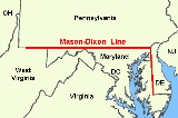
The
Mason–Dixon Line was surveyed between 1763 and 1767 by
Charles MasonCharles Mason was an English astronomer who made significant contributions to 18th-century science and American history, particularly through his involvement with the survey of the Mason-Dixon line, which came to mark the division between the northern and southern United States...
and
Jeremiah DixonJeremiah Dixon was an English surveyor and astronomer who is perhaps best known for his work with Charles Mason, from 1763 to 1767, in determining what was later called the Mason-Dixon line....
in the resolution of a border dispute between British colonies in
Colonial AmericaThe colonial history of the United States covers the history from the start of European settlement and especially the history of the thirteen colonies of Britain until they declared independence in 1776. In the late 16th century, England, France, Spain and the Netherlands launched major...
. It forms a
demarcation lineA demarcation line means simply a boundary around a specific area, but is commonly used to denote a temporary geopolitical border, often agreed upon as part of an armistice or ceasefire.See the following examples:...
among four
U.S. stateA U.S. state is any one of the 50 federated states of the United States of America that share sovereignty with the federal government. Because of this shared sovereignty, an American is a citizen both of the federal entity and of his or her state of domicile. Four states use the official title of...
s, forming part of the borders of
PennsylvaniaThe Commonwealth of Pennsylvania is a U.S. state that is located in the Northeastern and Mid-Atlantic regions of the United States. The state borders Delaware and Maryland to the south, West Virginia to the southwest, Ohio to the west, New York and Ontario, Canada, to the north, and New Jersey to...
,
MarylandMaryland is a U.S. state located in the Mid Atlantic region of the United States, bordering Virginia, West Virginia, and the District of Columbia to its south and west; Pennsylvania to its north; and Delaware to its east...
,
DelawareDelaware is a U.S. state located on the Atlantic Coast in the Mid-Atlantic region of the United States. It is bordered to the south and west by Maryland, and to the north by Pennsylvania...
, and
West VirginiaWest Virginia is a state in the Appalachian and Southeastern regions of the United States, bordered by Virginia to the southeast, Kentucky to the southwest, Ohio to the northwest, Pennsylvania to the northeast and Maryland to the east...
(then part of
VirginiaThe Commonwealth of Virginia , is a U.S. state on the Atlantic Coast of the Southern United States. Virginia is nicknamed the "Old Dominion" and sometimes the "Mother of Presidents" after the eight U.S. presidents born there...
). In popular usage, especially since the
Missouri CompromiseThe Missouri Compromise was an agreement passed in 1820 between the pro-slavery and anti-slavery factions in the United States Congress, involving primarily the regulation of slavery in the western territories. It prohibited slavery in the former Louisiana Territory north of the parallel 36°30'...
of 1820 (apparently the first official use of the term "Mason's and Dixon's Line"), the Mason–Dixon Line symbolizes a cultural boundary between the
Northeastern United StatesThe Northeastern United States is a region of the United States as defined by the United States Census Bureau.-Composition:The region comprises nine states: the New England states of Connecticut, Maine, Massachusetts, New Hampshire, Rhode Island and Vermont; and the Mid-Atlantic states of New...
and the
Southern United StatesThe Southern United States—commonly referred to as the American South, Dixie, or simply the South—constitutes a large distinctive area in the southeastern and south-central United States...
(
DixieDixie is a nickname for the Southern United States.- Origin of the name :According to the Oxford English Dictionary, the origins of this nickname remain obscure. According to A Dictionary of Americanisms on Historical Principles , by Mitford M...
) and legality of slavery as a result, although the Missouri Compromise Line had much more definitive geographic connection to slavery in the
United States leading up to the Civil WarIndustrialization went forward in the Northeast and a rail network linked the nation economically, opening up new markets. Immigration brought millions of European workers and farmers to the North...
.
Background
Maryland's charter granted the land north of the entire length of the
Potomac RiverThe Potomac River flows into the Chesapeake Bay, located along the mid-Atlantic coast of the United States. The river is approximately long, with a drainage area of about 14,700 square miles...
up to the
40th parallelThe 40th parallel north is a circle of latitude that is 40 degrees north of the Earth's equatorial plane. It crosses Europe, the Mediterranean Sea, Asia, the Pacific Ocean, North America, and the Atlantic Ocean....
. A problem arose when
Charles IICharles II was monarch of the three kingdoms of England, Scotland, and Ireland.Charles II's father, King Charles I, was executed at Whitehall on 30 January 1649, at the climax of the English Civil War...
granted a charter for Pennsylvania. The grant defined Pennsylvania's southern border as identical to Maryland's northern border, the 40th parallel. But the terms of the grant clearly indicate that Charles II and
William PennWilliam Penn was an English real estate entrepreneur, philosopher, and founder of the Province of Pennsylvania, the English North American colony and the future Commonwealth of Pennsylvania. He was an early champion of democracy and religious freedom, notable for his good relations and successful...
assumed the 40th parallel would intersect the Twelve-Mile Circle around
New Castle, DelawareNew Castle is a city in New Castle County, Delaware, six miles south of Wilmington, situated on the Delaware River. In 1900, 3,380 people lived here; in 1910, 3,351...
when in fact it falls north of Philadelphia, the site of which Penn had already selected for his colony's capital city. Negotiations ensued after the problem was discovered in 1681. A compromise proposed by Charles II in 1682, which might have resolved the issue, was undermined by Penn receiving the additional grant of the 'Three Lower Counties' along
Delaware BayDelaware Bay is a major estuary outlet of the Delaware River on the Northeast seaboard of the United States whose fresh water mixes for many miles with the waters of the Atlantic Ocean. It is in area. The bay is bordered by the State of New Jersey and the State of Delaware...
, which later became the
Delaware ColonyDelaware Colony in the North American Middle Colonies was a region of the Province of Pennsylvania although never legally a separate colony. From 1682 until 1776 it was part of the Penn proprietorship and was known as the lower counties...
, a satellite of Pennsylvania. These lands had been part of Maryland's original grant.
In 1732 the proprietary governor of Maryland,
Charles Calvert, 5th Baron BaltimoreCharles Calvert, 5th Baron Baltimore, 3rd Proprietor and 17th Proprietary Governor of Maryland, FRS was a British nobleman and Proprietary Governor of the Province of Maryland...
, signed a provisional agreement with
William PennWilliam Penn was an English real estate entrepreneur, philosopher, and founder of the Province of Pennsylvania, the English North American colony and the future Commonwealth of Pennsylvania. He was an early champion of democracy and religious freedom, notable for his good relations and successful...
's sons, which drew a line somewhere in between and renounced the Calvert claim to Delaware. But later, Lord Baltimore claimed that the document he had signed did not contain the terms he had agreed to, and refused to put the agreement into effect. Beginning in the mid-1730s, violence erupted between settlers claiming various loyalties to Maryland and Pennsylvania. The border conflict would be known as
Cresap's WarCresap's War was a border conflict between Pennsylvania and Maryland, fought in the 1730s...
.
The issue remained unresolved until the Crown intervened in 1760, ordering
Frederick Calvert, 6th Baron BaltimoreFrederick Calvert, 6th Baron Baltimore, 4th Proprietor of Maryland was an English nobleman and last in the line of Barons Baltimore...
to accept the 1732 agreement. Maryland's border with Delaware was to be based on the
Transpeninsular LineThe Transpeninsular Line is a surveyed line, the eastern half of which forms the north-south border between Delaware and Maryland...
and the Twelve-Mile Circle around New Castle. The Pennsylvania-Maryland border was defined as the line of latitude 15 miles south of the southernmost house in Philadelphia.
As part of the settlement, the Penns and Calverts commissioned the English team of
Charles MasonCharles Mason was an English astronomer who made significant contributions to 18th-century science and American history, particularly through his involvement with the survey of the Mason-Dixon line, which came to mark the division between the northern and southern United States...
and
Jeremiah DixonJeremiah Dixon was an English surveyor and astronomer who is perhaps best known for his work with Charles Mason, from 1763 to 1767, in determining what was later called the Mason-Dixon line....
to
surveySee Also: Public Land Survey SystemSurveying or land surveying is the technique, profession, and science of accurately determining the terrestrial or three-dimensional position of points and the distances and angles between them...
the newly established boundaries between the
Province of PennsylvaniaThe Province of Pennsylvania, also known as Pennsylvania Colony, was founded in British America by William Penn on March 4, 1681 as dictated in a royal charter granted by King Charles II...
, the
Province of MarylandThe Province of Maryland was an English and later British colony in North America that existed from 1632 until 1776, when it joined the other twelve of the Thirteen Colonies in rebellion against Great Britain and became the U.S...
,
Delaware ColonyDelaware Colony in the North American Middle Colonies was a region of the Province of Pennsylvania although never legally a separate colony. From 1682 until 1776 it was part of the Penn proprietorship and was known as the lower counties...
, and parts of Colony and Old Dominion of Virginia.
After Pennsylvania abolished slavery in 1781, the western part of this line and the
Ohio RiverThe Ohio River is the largest tributary, by volume, of the Mississippi River. At the confluence, the Ohio is even bigger than the Mississippi and, thus, is hydrologically the main stream of the whole river system, including the Allegheny River further upstream...
became a border between slave and free states, although Delaware retained slavery until the
Thirteenth AmendmentThe Thirteenth Amendment to the United States Constitution officially abolished and continues to prohibit slavery and involuntary servitude, except as punishment for a crime. It was passed by the Senate on April 8, 1864, passed by the House on January 31, 1865, and adopted on December 6, 1865. On...
was ratified in 1865.
Geography of the line
Mason and Dixon's actual survey line began to the south of
Philadelphia, PennsylvaniaPhiladelphia is the largest city in the Commonwealth of Pennsylvania and the county seat of Philadelphia County, with which it is coterminous. The city is located in the Northeastern United States along the Delaware and Schuylkill rivers. It is the fifth-most-populous city in the United States,...
, and extended from a
benchmarkThe term bench mark, or benchmark, originates from the chiseled horizontal marks that surveyors made in stone structures, into which an angle-iron could be placed to form a "bench" for a leveling rod, thus ensuring that a leveling rod could be accurately repositioned in the same place in the future...
east to the
Delaware RiverThe Delaware River is a major river on the Atlantic coast of the United States.A Dutch expedition led by Henry Hudson in 1609 first mapped the river. The river was christened the South River in the New Netherland colony that followed, in contrast to the North River, as the Hudson River was then...
and west to what was then the boundary with western Virginia.
The surveyors also fixed the boundary between Delaware and Pennsylvania and the approximately north–south portion of the boundary between Delaware and Maryland. Most of the Delaware–Pennsylvania boundary is an arc, and the Delaware–Maryland boundary does not run truly north-south because it was intended to bisect the
Delmarva PeninsulaThe Delmarva Peninsula is a large peninsula on the East Coast of the United States, occupied by most of Delaware and portions of Maryland and Virginia...
rather than follow a meridian.
The Maryland–Pennsylvania boundary is an east-west line with an approximate mean
latitudeIn geography, the latitude of a location on the Earth is the angular distance of that location south or north of the Equator. The latitude is an angle, and is usually measured in degrees . The equator has a latitude of 0°, the North pole has a latitude of 90° north , and the South pole has a...
of 39°43′20″ N (Datum WGS 84). In reality, the east-west Mason-Dixon line is not a true line in the geometric sense, but is instead a series of many adjoining lines, following a path between latitude 39°43′15″ N and 39°43′23″ N.
The surveyors also extended the boundary line to run between Pennsylvania and colonial western Virginia (which became West Virginia during the American Civil War, on June 20, 1863), though this was contrary to their original charter; this extension of the line was only confirmed later (see
Yohogania CountyYohogania County was created by the new state of Virginia in 1776, in an area long disputed between Virginia and Pennsylvania. The county ceased to exist after the border dispute between the two states was resolved in the 1780s...
for details).
The Mason–Dixon Line was marked by stones every mile and "crownstones" every five miles, using stone shipped from England. The Maryland side says (M) and the Delaware and Pennsylvania sides say (P). Crownstones include the two coats-of-arms. Today, while a number of the original stones are missing or buried, many are still visible, resting on public land and protected by iron cages.
Mason and Dixon confirmed earlier survey work which delineated Delaware's southern boundary from the Atlantic Ocean to the ”Middle Point” stone (along what is today known as the Transpeninsular Line). They proceeded nearly due north from this to the Pennsylvania border.
Later the line was marked in places by additional benchmarks and survey markers. The lines have been resurveyed several times over the centuries without substantive changes to Mason and Dixon's work. The stones may be a few to a few hundred feet east or west of the point Mason and Dixon thought they were; in any event, the line drawn from stone to stone forms the legal boundary.
According to Dave Doyle at the
National Geodetic SurveyNational Geodetic Survey, formerly called the U.S. Coast and Geodetic Survey , is a United States federal agency that defines and manages a national coordinate system, providing the foundation for transportation and communication; mapping and charting; and a large number of applications of science...
, part of the
National Oceanic and Atmospheric AdministrationThe National Oceanic and Atmospheric Administration , pronounced , like "noah", is a scientific agency within the United States Department of Commerce focused on the conditions of the oceans and the atmosphere...
, the common corner of Pennsylvania, Maryland, and Delaware, at The Wedge is marked by Boundary Monument #87. The marker ”MDP Corner” dates from 1935 and is offset on purpose.
Doyle said the Maryland–Pennsylvania Mason–Dixon Line is exactly:
- 39°43′19.92216″ N
and Boundary Monument #87 is on that parallel, at:
- 075°47′18.93851″ W.
Visitors to the tripoint are strongly encouraged to first obtain permission from the nearest landowner, or use the path from the arc corner monument which is bordered by Delaware parkland most of the way, and Pennsylvania parkland the entire way.
History
The line was established to end a boundary dispute between the British colonies of Maryland and Pennsylvania/Delaware. Maryland had been granted the territory north of the Potomac River up to the fortieth parallel. Pennsylvania's grant defined the colony's southern boundary as following Twelve Mile Circle counter-clockwise from the Delaware River until it hit "the beginning of the fortieth degree of Northern latitude." From there the boundary was to follow the fortieth parallel due west for five degrees of longitude. But the fortieth parallel does not in fact intersect the Twelve Mile Circle, instead lying significantly farther north. Thus the Pennsylvania's southern boundary as defined in its charter was contradictory and unclear. The most serious problem was that the Maryland claim would put
PhiladelphiaPhiladelphia is the largest city in the Commonwealth of Pennsylvania and the county seat of Philadelphia County, with which it is coterminous. The city is located in the Northeastern United States along the Delaware and Schuylkill rivers. It is the fifth-most-populous city in the United States,...
, which became the major city in Pennsylvania, within Maryland.
Appointed as Secretary of the Boundary Commission in 1750,
Benjamin Chew, Esq.Benjamin Chew was a third-generation American, a Quaker-born legal scholar, a prominent and successful Philadelphia lawyer, head of the Pennsylvania Judiciary System under both Colony and Commonwealth, and Chief Justice of the Supreme Court of the Province of Pennsylvania...
represented the
PennWilliam Penn was an English real estate entrepreneur, philosopher, and founder of the Province of Pennsylvania, the English North American colony and the future Commonwealth of Pennsylvania. He was an early champion of democracy and religious freedom, notable for his good relations and successful...
family for the following seventeen years in their boundary dispute with first
Charles Calvert, 5th Baron BaltimoreCharles Calvert, 5th Baron Baltimore, 3rd Proprietor and 17th Proprietary Governor of Maryland, FRS was a British nobleman and Proprietary Governor of the Province of Maryland...
and then his son
Frederick Calvert, 6th Baron BaltimoreFrederick Calvert, 6th Baron Baltimore, 4th Proprietor of Maryland was an English nobleman and last in the line of Barons Baltimore...
of Maryland until it was peacefully resolved in 1767. The boundary was fixed as follows:
- Between Pennsylvania and Maryland:
- The parallel (latitude line) 15 miles (24 km) south of the southernmost point in Philadelphia, measured to be at about 39°43′ N and agreed upon as the Maryland–Pennsylvania line.
- Between Delaware and Maryland:
- The existing east-west Transpeninsular Line from the Atlantic Ocean
The Atlantic Ocean is the second-largest of the world's oceanic divisions. With a total area of about , it covers approximately 20% of the Earth's surface and about 26% of its water surface area...
to the Chesapeake BayThe Chesapeake Bay is the largest estuary in the United States. It lies off the Atlantic Ocean, surrounded by Maryland and Virginia. The Chesapeake Bay's drainage basin covers in the District of Columbia and parts of six states: New York, Pennsylvania, Delaware, Maryland, Virginia, and West...
, as far as its mid-point from the Atlantic.
- A Twelve Mile (radius) Circle
The Twelve-Mile Circle is an approximately circular arc which forms most of the boundary between the Commonwealth of Pennsylvania and the State of Delaware in the United States...
(12 mi (19 km)) around the city of New Castle, Delaware.
- A "Tangent Line" connecting the mid-point of the Transpeninsular Line to the western side of the Twelve-Mile Circle.
- A "North Line" along the meridian (line of longitude) from the tangent point to the Maryland Pennsylvania border.
- Should any land within the Twelve-Mile Circle fall west of the North Line, it would remain part of Delaware. (This was indeed the case, and this border is the "Arc Line".)
The disputants engaged an expert British team, astronomer Charles Mason and surveyor Jeremiah Dixon, to survey what became known as the Mason–Dixon Line. It cost the Calverts of Maryland and the Penns of Pennsylvania £3,512/9 s to have 244 miles (393 km) surveyed with such accuracy. To them the money was well spent, for in a new country there was no other way of establishing ownership.
The Mason-Dixon line is made up of four segments corresponding to the terms of the settlement:
- Tangent Line
- North Line
- Arc Line
- the 39°43′ N parallel
The most difficult task was fixing the Tangent Line, as they had to confirm the accuracy of the Transpeninsular Line mid-point and the Twelve-Mile Circle, determine the tangent point along the circle, and then actually survey and monument the border. They then surveyed the North and Arc Lines. They did this work between 1763 and 1767. This actually left a small wedge of land in dispute between Delaware and Pennsylvania until 1921.
In April 1765, Mason and Dixon began their survey of the more famous Maryland-Pennsylvania line. They were commissioned to run it for a distance of five degrees of longitude west from the Delaware River, fixing the western boundary of Pennsylvania (see the entry for
Yohogania CountyYohogania County was created by the new state of Virginia in 1776, in an area long disputed between Virginia and Pennsylvania. The county ceased to exist after the border dispute between the two states was resolved in the 1780s...
). However, in October 1767, at
Dunkard CreekDunkard Creek is a stream that flows through Greene County, Pennsylvania and Monongalia County, West Virginia, near the towns of Mount Morris, Pennsylvania, and Blacksville, West Virginia...
near
Mount Morris, PennsylvaniaMount Morris is an unincorporated community in Greene County, Pennsylvania, United States.-Geography:Mount Morris is located at , on Interstate 79 near the West Virginia state line. Its elevation is 938 feet ....
, nearly 244 miles (393 km) west of the Delaware, their
IroquoisThe Iroquois , also known as the Haudenosaunee or the "People of the Longhouse", are an association of several tribes of indigenous people of North America...
guides refused to go any further, having reached the border of their lands with the
LenapeThe Lenape are an Algonquian group of Native Americans of the Northeastern Woodlands. They are also called Delaware Indians. As a result of the American Revolutionary War and later Indian removals from the eastern United States, today the main groups live in Canada, where they are enrolled in the...
, with whom they were engaged in hostilities. As such the group was forced to quit, and on October 11, they made their final observations 233 miles (375 km) from their starting point.
In 1784, surveyors
David RittenhouseDavid Rittenhouse was a renowned American astronomer, inventor, clockmaker, mathematician, surveyor, scientific instrument craftsman and public official...
and
Andrew EllicottAndrew Ellicott was a U.S. surveyor who helped map many of the territories west of the Appalachians, surveyed the boundaries of the District of Columbia, continued and completed Pierre Charles L'Enfant's work on the plan for Washington, D.C., and served as a teacher in survey methods for...
and their crew completed the survey of the Mason-Dixon line to the southwest corner of Pennsylvania, five degrees from the Delaware River. Other surveyors continued west to the Ohio River. The section of the line between the southwestern corner of Pennsylvania and the river is the county line between
MarshallAs of the census of 2000, there were 35,519 people, 14,207 households, and 10,101 families residing in the county. The population density was 116 people per square mile . There were 15,814 housing units at an average density of 52 per square mile...
and
WetzelAs of the census of 2000, there were 17,693 people, 7,164 households, and 5,079 families residing in the county. The population density was 49 people per square mile . There were 8,313 housing units at an average density of 23 per square mile...
counties, West Virginia.
The boundary between Pennsylvania and Maryland was resurveyed in 1849, then again in 1900.
On 14 November 1963, during the bicentennial of the Mason–Dixon Line, U.S. President
John F. KennedyJohn Fitzgerald "Jack" Kennedy , often referred to by his initials JFK, was the 35th President of the United States, serving from 1961 until his assassination in 1963....
opened a newly completed section of
Interstate 95Interstate 95 is the main highway on the East Coast of the United States, running parallel to the Atlantic Ocean from Maine to Florida and serving some of the most populated urban areas in the country, including Boston, Providence, New Haven, New York City, Newark, Philadelphia, Baltimore,...
where it crossed the Maryland-Delaware border. It was one of his last public appearances before his
assassinationJohn Fitzgerald Kennedy, the thirty-fifth President of the United States, was assassinated at 12:30 p.m. Central Standard Time on Friday, November 22, 1963, in Dealey Plaza, Dallas, Texas...
in
Dallas, TexasDallas is the third-largest city in Texas and the ninth-largest in the United States. The Dallas-Fort Worth Metroplex is the largest metropolitan area in the South and fourth-largest metropolitan area in the United States...
. The
Delaware TurnpikeThe Delaware Turnpike, also known as the John F. Kennedy Memorial Highway, is an tolled highway that lies entirely within the state of Delaware. Running in a general southwest to northeast direction, paralleling nearby U.S...
and the Maryland portion of the new road were later designated as the John F. Kennedy Memorial Highway.
Systematic errors and experiments to weigh the earth
Mason and Dixon could only do the work as accurately as they did due to the work of
Nevil MaskelyneThe Reverend Dr Nevil Maskelyne FRS was the fifth English Astronomer Royal. He held the office from 1765 to 1811.-Biography:...
, some of whose instruments they used. There was keen interest in their work and much communication between the surveyors, Maskelyne and other members of the British Scientific establishment in the
Royal SocietyThe Royal Society of London for Improving Natural Knowledge, known simply as the Royal Society, is a learned society for science, and is possibly the oldest such society in existence. Founded in November 1660, it was granted a Royal Charter by King Charles II as the "Royal Society of London"...
in England, notably
Henry CavendishHenry Cavendish FRS was a British scientist noted for his discovery of hydrogen or what he called "inflammable air". He described the density of inflammable air, which formed water on combustion, in a 1766 paper "On Factitious Airs". Antoine Lavoisier later reproduced Cavendish's experiment and...
.
During such survey work it is normal to survey from point to point along the line and then survey back to the starting point which with no errors would coincide. Normally the return errors would be random – i.e. the return survey errors compared to the intermediate points back to the start point would be spacially randomly distributed around the start point. Mason and Dixon found that there were larger than expected
systematic errorSystematic errors are biases in measurement which lead to the situation where the mean of many separate measurements differs significantly from the actual value of the measured attribute. All measurements are prone to systematic errors, often of several different types...
s, that is non
randomRandom errors are errors in measurement that lead to measurable values being inconsistent when repeated measures of a constant attribute or quantity are taken...
, that led the return survey consistently in one direction away from the starting point. When this information got back to the Royal Society members, Henry Cavendish realised that this may have been due to the gravitational pull of the
Allegheny MountainsThe Allegheny Mountain Range , also spelled Alleghany, Allegany and, informally, the Alleghenies, is part of the vast Appalachian Mountain Range of the eastern United States and Canada...
deflecting the
theodoliteA theodolite is a precision instrument for measuring angles in the horizontal and vertical planes. Theodolites are mainly used for surveying applications, and have been adapted for specialized purposes in fields like metrology and rocket launch technology...
plumb-bobA plumb-bob or a plummet is a weight, usually with a pointed tip on the bottom, that is suspended from a string and used as a vertical reference line, or plumb-line....
s and
spirit levelA spirit level or bubble level is an instrument designed to indicate whether a surface ishorizontal or vertical . Different types of spirit levels may be used by carpenters, stonemasons, bricklayers, other building trades workers, surveyors, millwrights and other metalworkers, and in some...
s. Maskelyne proposed measuring the gravitational force deflection induced by the pull of a nearby mountain upon a plumb-bob in 1772 and sent Mason (who had returned to England) on a site survey through central England and Scotland to find a suitable location during the summer of 1773. Mason selected
SchiehallionSchiehallion is a prominent mountain in Perth and Kinross, Scotland. Schiehallion has a rich botanical life, interesting archaeology, and a unique place in scientific history for an 18th-century experiment in 'weighing the world'...
at which to conduct what became known as the
Schiehallion experimentThe Schiehallion experiment was an 18th-century experiment to determine the mean density of the Earth. Funded by a grant from the Royal Society, it was conducted in the summer of 1774 around the Scottish mountain of Schiehallion, Perthshire. The experiment involved measuring the tiny deflection of...
which was carried out primarily by Maskelyne and determined the density of the Scottish mountain. Several years later Cavendish used a very sensitive torsion balance to carry out the
Cavendish experimentThe Cavendish experiment, performed in 1797–98 by British scientist Henry Cavendish was the first experiment to measure the force of gravity between masses in the laboratory, and the first to yield accurate values for the gravitational constant. Because of the unit conventions then in use,...
and determine the density of the Earth.
In popular culture
Mason & DixonMason & Dixon is a postmodernist novel by American author Thomas Pynchon published in 1997. It centers on the collaboration of the historical Charles Mason and Jeremiah Dixon in their astronomical and surveying exploits in Cape Colony, Saint Helena, Great Britain and along the Mason-Dixon line in...
is the title of an acclaimed 1997 novel by American author
Thomas PynchonThomas Ruggles Pynchon, Jr. is an American novelist. For his most praised novel, Gravity's Rainbow, Pynchon received the National Book Award, and is regularly cited as a contender for the Nobel Prize in Literature...
. The novel meanders widely through the lives of Mason & Dixon, traditional American history and other themes such as hollow earth theory,
geomancyGeomancy is a method of divination that interprets markings on the ground or the patterns formed by tossed handfuls of soil, rocks, or sand...
,
deismDeism in religious philosophy is the belief that reason and observation of the natural world, without the need for organized religion, can determine that the universe is the product of an all-powerful creator. According to deists, the creator does not intervene in human affairs or suspend the...
and alien abduction.
The lives of Charles Mason and Jeremiah Dixon are the subject of
Sailing to PhiladelphiaSailing to Philadelphia is the second solo album by Mark Knopfler, released on 26 September 2000. The title track is drawn from Thomas Pynchon's novel about Charles Mason and Jeremiah Dixon, the two English surveyors who established the border between Pennsylvania and Maryland, Delaware and...
, the title track on
Mark Knopfler’sMark Freuder Knopfler, OBE is a Scottish-born British guitarist, singer, songwriter, record producer and film score composer. He is best known as the lead guitarist, vocalist, and songwriter for the British rock band Dire Straits, which he co-founded in 1977...
2000 second solo album. In part inspired by Thomas Pynchon's novel, the song is a duet with
James TaylorJames Vernon Taylor is an American singer-songwriter and guitarist. A five-time Grammy Award winner, Taylor was inducted into the Rock & Roll Hall of Fame in 2000....
, where the two protagonists speak of their hopes and fears as they arrive on the ship in the new world for the first time.
Mason "The Line" Dixon is a leading character in
Rocky BalboaRocky Balboa is the sixth and final film in the Rocky franchise, directed by and starring Sylvester Stallone. The film, which was also written by Stallone who plays underdog boxer Rocky Balboa, is the sixth film in the Rocky series that began with the Academy Award-winning Rocky thirty years...
, the sixth and final film in the
RockyRocky is a 1976 American sports drama film directed by John G. Avildsen and both written by and starring Sylvester Stallone. It tells the rags to riches American Dream story of Rocky Balboa, an uneducated but kind-hearted debt collector for a loan shark in the city of Philadelphia, Pennsylvania...
franchise, directed by and starring
Sylvester StalloneMichael Sylvester Gardenzio Stallone , commonly known as Sylvester Stallone, and nicknamed Sly Stallone, is an American actor, filmmaker, screenwriter, film director and occasional painter. Stallone is known for his machismo and Hollywood action roles. Two of the notable characters he has portrayed...
. Played by real-life boxer
Antonio TarverAntonio Deon Tarver , nicknamed the "Magic Man", is a professional boxer from Orlando, Florida and the former WBC, WBA, IBF, & The Ring light heavyweight champion....
, Dixon is the current World Heavyweight Champion who is ridiculed for having never gone up against a real contender, and who thus agrees to an exhibition fight against the near 60 year old Rocky Balboa.
Further reading
- Danson, Edwin. Drawing the Line: How Mason and Dixon Surveyed the Most Famous Border in America. Wiley. ISBN 0-471-38502-6.
- Ecenbarger, Bill. Walkin' the Line: A Journey from Past to Present Along the Mason-Dixon . M. Evans. ISBN 978-0-87131-962-3.
External links