

U.S. Route 40
Encyclopedia
U.S. Route 40 is an east–west United States highway. As with most routes whose numbers end in a zero, U.S. 40 once traversed the entire United States
. It is one of the original 1920s U.S. Highways, and its first termini were San Francisco, California
, and Atlantic City, New Jersey
. The western end has been truncated several times, and the route now ends at Interstate 80
just outside of Park City, Utah
, near Salt Lake City.
Starting at its western terminus in Utah
, U.S. 40 crosses a total of 12 states, including Colorado
, Kansas
, Missouri
, Illinois
, Indiana
, Ohio
, West Virginia
, Pennsylvania
, Maryland
, Delaware
, and New Jersey
. Three former and four current state capitals lie along the route. For much of its route, U.S. 40 runs parallel to or concurrently with several major Interstate Highways: Interstate 70
from Colorado
, to Washington, Pennsylvania
; and again from Hancock, Maryland
to Baltimore, Maryland; Interstate 64
in parts of Missouri and Illinois; Interstate 68
along the Maryland
Panhandle; and Interstate 95
from Baltimore
to New Castle, Delaware
.
The route was built on top of several older highways, most notably the National Road
and Victory Highway
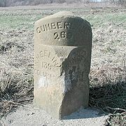
. The National Road was created in 1806 by an act of Congress to serve as the first Federally funded highway construction project. When completed it connected Cumberland, Maryland
, with Vandalia, Illinois
. The Victory Highway was designated as a memorial to World War I
veterans and went from Kansas City, Missouri
to San Francisco, California
. Other important roads that have become part of U.S. 40 include Zane's Trace
in Ohio, Braddock Road in Maryland and Pennsylvania, part of the Oregon Trail
in Kansas, and the Lincoln Highway
(the first road across America) in California
.
|UT
|174.54
|280.89
|-
|CO
|496.44
|798.94
|-
|KS
|423.67
|681.83
|-
|MO
|255.05
|410.46
|-
|IL
|159.99
|257.48
|-
|IN
|143.95
|231.67
|-
|OH
|228.37
|367.53
|-
|WV
|15.87
|25.54
|-
|PA
|82.46
|132.71
|-
|MD
|220.88
|355.47
|-
|DE
|17.18
|27.65
|-
|NJ
|64.28
|103.45
|-
|}
at Interstate 80
, several miles north of Park City, at Silver Creek Junction. The road is a limited access highway from the I-80 junction to its intersection with Utah State Route 32
south of Park City, about 13 miles (21 km). From there, the road takes a generally southerly course to Heber City before turning southeast and passing by the northern shores of Strawberry Reservoir
. U.S. 40 goes through the towns of Duchesne
, Roosevelt
and Vernal
before entering Colorado.
Entering Colorado
2 miles (3.2 km) west of Dinosaur
, US 40 mainly continues east through the Routt National Forest through Craig
and Steamboat Springs
. The highway continues southeast toward Denver, where it intersects with I-70, where it concurrent with for more than 140 miles (225.3 km) to Kit Carson
. US 40 continues east from Kit Carson to Arapahoe
where it travels east in to Kansas.
 US-40 enters Kansas
near the unincorporated community of Weskan. The first sizable town it enters is Sharon Springs
, where it intersects K-27
. From there it goes northeast to Oakley
and follows Eagle Eye Road before a merge with I-70 east of town. The two routes remain merged until Topeka
, though the prior alignment of US-40, named Old Highway 40, parallels I-70 for most of the way. From Ellsworth
to Salina
, the old alignment of US-40 is signed as K-140
.
In Topeka, US-40 leaves I-70 at exit 366, follows the Oakland Expressway concurrent with K-4
north to 6th Avenue, then heads east along 6th out of town. Through Topeka, US-40 closely follows the route of the Oregon Trail
. At the Shawnee
-Douglas
county line near Big Springs
, US-40 crosses to the south of I-70 and enters Lawrence
from the west along West 6th Street. In Lawrence, the route is joined by US-59 and jogs north to cross the Kansas River
. It follows North 2nd and North 3rd Streets, crosses back under I-70, leaves US-59, and merges with US-24 before leaving town.
US-40 remains merged with US-24 as the two routes travel northeast to the town of Tonganoxie
. From there, the merged routes turn due east toward Kansas City, Kansas
. In Kansas City, US-40 and US-24 intersect US-73 and K-7
, and turning south toward Interstate 70
. US-40, along with US-24, then merge onto I-70 and recross the Kansas River over the Lewis and Clark Viaduct just before entering Kansas City, Missouri
.
On December 1, 2008, US-40, along with US-24 and US-73, was rerouted south along K-7 west of Kansas City to the intersection with I-70. Before this date, US-40 and US-24 continued along State Avenue to College Parkway before turning right to follow Turner Diagonal for 1/2 where US-40 joined Interstate 70 for the duration of its journey eastward toward Missouri.
In 1951, the State of Kansas designated Route 40 as a Blue Star Memorial Highway
from border to border.
 US 40 enters Missouri
in Kansas City and leaves it in St. Louis on the Poplar Street Bridge
across the Mississippi River
. US-40 travels east–west across the center of the state, parallel to I-70.
US-40 enters Missouri in Kansas City along a concurrency with I-70. It leaves I-70 at exit 6 and follows Van Brunt Boulevard for a short distance before turning east and crossing I-70 again at exit 7A. US-40 parallels I-70 to the north through Kansas City until exit 11, where it crosses and parallels it to the south through the suburbs of Lee's Summit
, Independence
, Blue Springs
and Grain Valley
before rejoining I-70 at exit 24. An older alignment caries the designation "Old US-40".
US-40 stays with I-70 until Boonville
, where US-40 leaves at exit 101, along with Business Loop I-70. Both designations follow Ashley Road, before US-40 leaves and heads north along Main Street. After crossing the Missouri River
in Boonville, US-40 turns east before rejoining I-70 at exit 121, at the outskirts of Columbia
. The two routes remain concurrent until exit 210B in Wentzville
.
From Wentzville, US-40 joins I-64 and US-61 and heads southeast crossing the Missouri River over the Daniel Boone Bridge
in St. Charles. US-40 stays joined with I-64 and leaves the state in St. Louis
on the Poplar Street Bridge
across the Mississippi River
along with I-70, I-55.
Until 1926, US-40 in Missouri was Route 2.
On January 2, 2008, five miles (8 km) of US-40/I-64 in St. Louis was closed eastbound and westbound from I-170 to I-270
. It re-opened December 15, 2008 two weeks ahead of the original scheduled date of December 31, 2008. On December 13, 2008, another five-mile (8 km) section of the freeway closed both ways from I-170 to the Kingshighway exit in the city. It was re-opened on December 7, 2009. The entire freeway is now open for travel, with the speed limit raised to 60 mph on most of the stretch. It is also now a full freeway all the way from Downtown St. Louis to Wentzville.
 The next 159.99 miles (257.48 km) of US 40 lies within the state of Illinois
. Except where the route has been re-aligned with Interstate 70, it is an entirely undivided surface route. Formerly a major highway, it has lost most of its non-local traffic to Interstate 70. Some early bypasses of towns were built with the apparent intention of twinning them as a divided highway with access limited to intersections. I-70 uses none of those old bypasses that remain as sections of US 40. The westernmost portion of the historic National Road
lies on most of the U.S. 40 alignment in Illinois.
US 40 crosses into Illinois at East St. Louis
on the Poplar Street Bridge concurrent with Interstates 55
, 64
and Interstate 70
. The route will continue to have a close relationship with I-70 for the remainder of the time it spends in the state; either directly concurrent with or paralleling it throughout Illinois.
Between Pocahontas
and Mulberry Grove
, US 40 passes through several small towns. In Vandalia, Illinois
, the former state capitol, it follows Veterans Avenue and Kennedy Boulevard (with US 51
) through town. The Old State House
in Vandalia marks the western terminus of the National Road
, one of the earliest roads upon which US 40 was designated. From Vandalia, the road continues to the northeast passing through the early German settlement town of Teutopolis and several city streets in Effingham
. Beyond Effingham, US 40 passes through many small unincorporated towns before leaving the state near Marshall
.
between southern
and northern
Indiana.
US 40 enters Indiana
from the west at unincorporated Liggett
along with I-70. US 40 leaves the interstate at exit 11 and heads north with SR 46. The road leaves the city to the northeast once reaching Wabash Ave.
Once leaving Terre Haute, US 40 passes through the small towns of Seelyville
, Brazil
, Knightsville
and Harmony
. Between Seelyville and Brazil, the road bypasses several small unincorporated communities which are served by State Road 340, a former alignment of US 40. The road continues to the northeast beyond Harmony, passing many unincorporated places such as Mount Meridian
along the way to Plainfield
, a suburb of Indianapolis
.
 In Plainfield, US 40 is Main Street and passes the Metropolis Outdoor Shopping Mall
and a nostalgic stainless steel diner. Once leaving Plainfield, US 40 becomes Washington Street
, where it passes by the northern edge of Indianapolis International Airport
. After passing the airport, US 40 is now routed onto Interstate 465
Southbound on the west side of Indianapolis. A sign along the entrance ramp advises motorists "For US 40 East, Follow I-465 South to Exit 46." This route bypasses downtown Indianapolis and instead goes through the southern part of Indianapolis; its nearest point is about 5 miles (8 km) south of the city center. (Previously, the highway did not join with I-465 but continued along Washington Street, where it entered Indianapolis proper near Eagle Creek, a tributary of the White River
. In downtown Indianapolis, the old highway split into a pair of one-way streets: Washington Street carries westbound traffic and Maryland Street carries eastbound traffic. In Indianapolis, the old highway passes several key landmarks, including White River State Park
, the Indianapolis Zoo
, the Eiteljorg Museum, Victory Field
, the Lucas Oil Stadium
, and the Indiana Statehouse). Along the eastern edge of Indianapolis, US 40 leaves I-465 at Exit 46 and is once again routed onto Washington Street.
East of Indianapolis, US 40 enters Cumberland
where it takes the name National Road. Paralleling I-70 at a distance of about 3.5 miles (5.6 km), US 40 continues eastward across Indiana, passing through such communities as Greenfield
, Knightstown
, Lewisville
, Straughn
, Dublin
, Mount Auburn
, and Cambridge City
, where it is known by various local names including Washington Street, Main Street, or National Road.
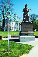
US 40's last stop in Indiana is the city of Richmond
. In Richmond, it passes a statue known as "Madonna of the Trail
", one of a series of twelve statues across the U.S. to memorialize women pioneers who made the trek to settle the western U.S.
In 1968, a section of US 40 (Main Street) in Richmond was destroyed by a massive gas explosion. This caused a section of Main Street to be closed to automobile traffic, and US 40 was rerouted along North A Street (westbound) and South A Street (eastbound). At the Indiana/Ohio border, US 40 crosses I-70 at exit 156B before entering Ohio.
just to the south of New Paris
. The road is always close to the newer I-70 eastward toward Dayton
. In Vandalia
, the road passes to the south of Dayton International Airport
and crosses I-75
and the Great Miami River
. The road never actually enters Dayton, instead skirting the northern suburbs on the way toward Springfield
.
In Springfield, US 40 is split between two one-way streets. North Street carries US 40 West and Columbia Street carries US 40 East. The route then shifts on to East Main Street before leaving town to the east, once again as National Road. I-70 crosses again at unincorporated Harmony. US 40 passes just north of London
where it intersects Ohio State Route 56
and US 42 before heading into West Jefferson
. In West Jefferson, US 40 is designated along Main Street.
 In the Columbus
metropolitan area, US 40 enters from the west as Broad Street. Among the sites along US 40 in Columbus are the Ohio Statehouse
, the Columbus Museum of Art
, and LeVeque Tower
, the oldest skyscraper in Columbus. In Bexley
, the route follows Main Street, using Drexel Avenue to get between Broad and Main. US 40 continues as Main Street through Reynoldsburg
before leaving the Columbus area as National Road yet again.
East of the Columbus metro area, US 40 parallels I-70 at a distance of about 1 miles (2 km), passing through several small towns such as Kirkersville
and Hebron
. In Zanesville
, the road becomes Main Street, and at the center of town US 40 begins a concurrency with US 22
that carries it to Cambridge
. US 40 crosses the Muskingum River
in Zanesville on the famous Y-Bridge
. Routes 22 and 40 enter Cambridge from the southwest along John Glenn Highway, and split in town; US 40 follows Wheeling Avenue. In Old Washington
, US 40 joins I-70 at Exit 186. It leaves I-70 at exit 201 near Morristown
. The two roads cross paths several times before they both leave Ohio on a pair of bridges
across the Ohio River
at Bridgeport
.
The now-decommissioned Ohio State Route 440 ran along old US 40 in places where US 40 had been shifted onto I-70.
path to I-70.
 US 40 enters Pennsylvania at West Alexander
. It closely parallels I-70 from West Virginia until it reaches Washington
where it follows Jefferson Avenue and Maiden Street. In Washington, US 40 passes to the south of Washington & Jefferson College
. Following Maiden Street out of town, the road turns southeast toward the town of California
. A short limited access highway in California and West Brownsville
provides an approach to the Lane Bane Bridge
across the Monongahela River
. From here, the road continues southeast to Uniontown
.
US 40 bypasses Uniontown along a limited access highway that also carries US 119
. An old alignment through Uniontown is signed as "Business US 40." Southeast of Uniontown, travellers pass the Fort Necessity National Battlefield
. It follows Braddock Road southeast of Uniontown, crossing the Youghiogheny River Lake
on a bridge completed in 2006. US 40 leaves Pennsylvania at Addison
from Pennsylvania near Grantsville
in the western part of the state
. Here, and through most of the state, it is known as National Pike. US 40 leaves National Pike shortly after entering Maryland from the northwest and merges with I-68
and US 219
at exit 14B. The old alignment of US 40, still known as National Pike, is signed through much of the western part of the state as either "Scenic US 40" or "Alternate US 40". US 219 leaves the three-way concurrency at exit 22, but US 40 and I-68 remain on the same pavement through Frostburg
and Cumberland
.
East of Cumberland, the old National Pike (formerly US 40) carries the MD 144
designation. The I-68/US 40 roadway passes through a 340 feet (103.6 m) deep cut in Sideling Hill
. Just to the east of the cut is the Sideling Hill Exhibit Center, a museum that highlights Western Maryland geology. At Hancock
, where the state of Maryland narrows to less than two miles (3 km) wide, I-68 ends, and US 40 merges onto I-70 at exit 1. The two routes closely follow the course of the Chesapeake and Ohio Canal
and the Potomac River
for several miles before US 40 leaves the Interstate at exit 9. US 40 passes directly through the center of Hagerstown
using Washington Avenue (eastbound) and Franklin Street (westbound). Heading southeast out of Hagerstown, US 40 diverges into two separate routes, US 40 and US 40 Alt. US 40 parallels I-70, its longtime travel partner, crossing it at exit 32 near Greenbrier State Park
on the Baltimore National Pike alignment. US 40 Alt heads southeast on the Old National Pike alignment through Boonsboro
, crossing South Mountain
at Turner's Gap
. The two routes converge just west of Frederick.
 In Frederick
, US 40 uses Patrick Street before merging onto the US 15
expressway for a short distance. It leaves US 15 and rejoins I-70 on the outskirts of Frederick. MD 144 once again takes over along the old alignment of US 40.
US 40 leaves I-70 for the final time upon entering the western suburbs of Baltimore, once again as Baltimore National Pike. The route passes through Patapsco Valley State Park
north of Ellicott City
and enters the Baltimore city limits along Edmondson Avenue. East of Gwynns Falls Park, US 40 becomes Franklin Street, and becomes an expressway (formerly I-170
) for a short distance between Pulaski Street and Martin Luther King Jr. Boulevard. Through this area, an alignment called "Truck US 40" diverts larger vehicles onto an alternate route. US 40 passes through the Mount Vernon neighborhood and a few blocks from Baltimore's Washington Monument
. After crossing the Jones Falls Expressway (I-83
), US 40 follows Orleans Street, and finally becomes the Pulaski Highway as it leaves Baltimore to the northeast.
US 40, for the entire length of Pulaski Highway, closely parallels I-95
. Pulaski Highway passes through Gunpowder Falls State Park
near Joppa
and the Aberdeen Proving Ground
. Between Havre de Grace
and Perryville
it crosses the Susquehanna River
on the Thomas J. Hatem Memorial Bridge
. US 40 leaves Maryland in Elkton
, crossing the border into Delaware.

for about 15 miles (24 km). Entering the state from Maryland in Glasgow
, it continues along the Pulaski Highway. It crosses Delaware Route 1 in the community of Bear
before merging with US 13
and the Dupont Highway in Midvale. The concurrent routes pass the New Castle Airport
and US 40 leaves to join I-295
near Wilmington Manor
. US 40, along with I-295, uses the Delaware Memorial Bridge
to cross the Delaware River
into New Jersey.
 US 40 enters New Jersey
in Deepwater, New Jersey
along with I-295. US 40 briefly joins the New Jersey Turnpike
, and exits to the south of the toll booth
s. The route follows Wiley Road, parallel to the Turnpike, before joining Harding Highway in Carneys Point
. US 40 will be Harding Highway through most of South Jersey
. Northeast of where US 40 joins it, Harding Highway carries the NJ 48 designation; though this was once part of US 40 as well.
It enters the borough
of Woodstown
as a concurrency with NJ 45 along West Avenue; it leaves town heading southeast. In Upper Pittsgrove Township
, the road changes names to the Pole Tavern-Elmer Road. Passing through Elmer
it becomes Chestnut St. and then Elmer-Malaga Road. In Malaga
it uses Delsea Drive. The route bypasses the city of Vineland
to the northeast, and becomes Cape May Avenue in Hamilton Township
, where it runs concurrent with NJ 50. In Mays Landing
US 40 uses Main Street.
US 40 merges with US 322
and the Black Horse Pike
in McKee City
. The two routes enter Atlantic City
along Albany Boulevard and pass the Atlantic City Airport
. US 40 and US 322 both reach their eastern terminus at the intersection of Albany Boulevard and Ventnor Avenue.
and Mingo Path in the Maryland-Pennsylvania area, followed similar alignments to US 40. Early American colonists established roads, some following the established Native American paths, that would later serve as US 40. These included a segment of post road between Wilmington, Delaware
, and Baltimore, Maryland. In 1755, during the French and Indian Wars
, General Edward Braddock blazed a trail en route to capture Fort Duquesne
(modern Pittsburgh, Pennsylvania
). US 40 closely follows this route between Cumberland, Maryland
and Uniontown, Pennsylvania
.
Early in the history of the U.S., the State of Maryland established a network of turnpikes
for long-distance travel. Three of these would later serve as part of US 40: the Baltimore and Havre de Grace
Turnpike, the Baltimore and Frederick
Turnpike, and Bank Road. Colonel Ebenezer Zane
(for whom Zanesville, Ohio
was named) blazed some of the first trails across the Ohio wilderness in the last years of the 18th century. Zane's Trace
, as his road was called, stretched from Wheeling, West Virginia
, to Maysville, Ohio. With some minor alignment differences, US 40 closely matches the segment from Wheeling to Zanesville.
Between the cities of Lawrence
and Topeka, Kansas
, US 40 follows the path of the Oregon Trail
. During the 19th century, the Oregon Trail served as a major thoroughfare for people emigrating to the Pacific Northwest
. Between 1850 and 1852, some 65,000-70,000 people traveled the trail.
Most of the western section of US 40 follows the former route of Victory Highway
, a road that once linked Kansas City to San Francisco. The road was named as a memorial to fallen World War I veterans. Other than two sections (one in California and one in Kansas/Colorado) most of the original route of US 40 west of Kansas City used Victory Highway. According to a 1926 guide published about the Victory Highway, it was the fastest route between San Francisco and Salt Lake City, allowing travellers to complete the 784 miles (1,262 km) trip "comfortably and in high gear in from 3 to 4 days." Controversy over the routing of US 40 over the Victory Highway led to a "divided route", with US 40S following the Victory Highway and US 40N taking a more northerly route.
 In 1806, Thomas Jefferson
signed into law an act of Congress establishing a National Road to connect the waters of the Atlantic Ocean
with the Ohio River
. The law mentions Baltimore as its eastern terminus; but the route used established Maryland turnpikes east of Cumberland. A new road was constructed from Cumberland to Wheeling, West Virginia, and later extended across the states of Ohio
, Indiana
, and Illinois
. Segments of the National Road used Braddock's Road and Zane's Trace. Plans to extend the road to Missouri
were never completed. The farthest western terminus for the National Road was the Old State House in Vandalia, Illinois
.
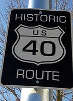
The National Road was absorbed into the National Old Trails Ocean-to-Ocean highway, a route from New York, New York, to Los Angeles, California
in the early 20th century. During the planning phases of what would become the U.S. Federal Highway System, the National Road was originally to be US 1. This would have disrupted the organized numbering system, however, and the National Road became US 40 in the original 1925 plan for U.S. Routes. To this day, many places still name US 40 "National Road", even where the alignment was moved from the original road. Besides US 40, much of the National Road is paralleled by segments of Interstates 68
and 70
.
. Portions of Historic Route 40 exist in Vallejo, along Broadway. In Cordelia and Suisun City, the original route is along Cordelia Road. It is also signed at as a historic route. The original route is preserved as Texas Street in Fairfield
. In Vacaville
the highway is preserved as Monte Vista Avenue. In Davis
, the highway is now Russell Boulevard, the main street through downtown Davis. In Sacramento
the highway followed the routes of modern Capitol Avenue, SR 160
and Auburn Boulevard. Through the Sierra Nevada many portions are still drivable, crossing I-80. Portions still drivable include Applegate Road in Applegate
, Hampshire Rocks Road in a rural area near Cisco, and Donner Pass Road over Donner Pass
and into Truckee
. Between Truckee and the Nevada state line, the former route of US 40 is mostly visible from the freeway, but not drivable as a contiguous route. Portions accessible include Glenshire Drive, Hirshdale Road and Floriston Way.
. Donner Pass, elevation 7,085 ft (2,160 m), was closed through many weeks in the winter months. This alternate route used Beckwourth Pass
, elevation of 5,221 ft (1,591 m). Since Beckwourth Pass was nearly 2,000 ft, (610 m), lower than Donner Pass, it could be kept open for a much longer time during the year. ALT U.S. 40 parted the main track of U.S. 40 near Davis
and ran north along what was then signed as U.S. Route 99W into Woodland
. From Woodland, ALT U.S. 40 ran north along California State Route 24
through Knights Landing
and Robbins
into Yuba City
. Most of the section from Woodland to Yuba City is now signed as California State Route 113
. From Yuba City, ALT U.S. 40 ran east through Marysville
, then north through Oroville
. Continuing north and northeast, ALT U.S. 40 reached Paxton
, then turned south and southeast to Quincy
and Beckwourth
before crossing. East of Beckwourth Pass, ALT U.S. 40 descended to meet U.S. Route 395
at what is now Hallelujah Junction
. The section from Marysville to U.S. Route 395 was then still an extension of Route 24, but is now signed as California State Route 70
, although much of the old highway was moved further west before Lake Oroville
was dammed and flooded in 1968.
the route is still drivable as 3rd street
in Verdi and 4th street
in Reno
and Victorian Ave
in Sparks
. In rural Nevada the highway forms the business loops for Wadsworth
, Fernley
, Lovelock
, Winnemucca, Battle Mountain
, Carlin
, Elko
, and West Wendover.
the former route of US 40 is signed as SR-58
and runs along a now unmentioned road just south of the freeway across the Bonneville Salt Flats. The route re-emerges from the shadow of I-80 as SR-138
through Grantsville
and Tooele
. In Salt Lake City
U.S. 40 was routed on North Temple Street on the west side of town. Past Temple Square
US-40 had two alignments, originally along 2100 South and Parley's Way, at the time part of SR-201, but was later moved to Foothill Boulevard, along modern SR-186. East of Park City
US 40 is still intact.
 US 40 was one of the original 1925 U.S. Highways. The route was a cross-country, east–west route, as most routes with a "0" number were defined. In 1926, the road had a total mileage of 3228 miles (5,195 km). Though the eastern terminus was planned for State Road, Delaware, by 1927 it was moved to Atlantic City, New Jersey
. The western terminus was San Francisco
via an auto ferry across San Francisco Bay
from Berkeley, California
(see Berkeley Pier
). Upon completion of the San Francisco – Oakland Bay Bridge, U.S. 40 was re-routed over the bridge, bypassing the ferry pier. Early alignments of the road featured ferries at both ends. To cross the Delaware River
, ferries were used, originally from Wilmington, Delaware (1927–1929) and later from New Castle, Delaware
(1929–1951). In 1951, the opening of the Delaware Memorial Bridge
replaced the ferry service and carried US 40 across the Delaware River.
From 1926-1935 the route split in Manhattan, Kansas
, into "40N" and "40S" routes; the two routes met again in Limon, Colorado
. The "40S" route continued on to Grand Junction, Colorado
. In 1935, the split routes were eliminated. US 40N between Manhattan and Limon and then US 40S from Limon to Grand Junction was replaced by U.S. Route 24
, the remainder was renumbered as simply US 40.
.svg.png) New alignments for the road were designated in Maryland
New alignments for the road were designated in Maryland
in 1948 and in Utah
in 1950. California's segment of the highway was decommissioned in 1964. By 1966, the western terminus moved to Reno, Nevada
. The road shortened again in 1975, to its current western end at Silver Creek Junction, Utah
. In 1998, the California segment was given a sort of rebirth with the designation of Historic Route 40 through that state. Further realignments occurred in Utah
where the highway was re-routed for the Jordanelle Reservoir
in the mid 1990s, and Kansas City, Kansas
, in 1999 to make way for the Kansas Speedway
. On December 1, 2008, a further realignment in Kansas City rerouted US 40 away from State Avenue and the Turner Diagonal and onto K-7
and Interstate 70.
United States
The United States of America is a federal constitutional republic comprising fifty states and a federal district...
. It is one of the original 1920s U.S. Highways, and its first termini were San Francisco, California
San Francisco, California
San Francisco , officially the City and County of San Francisco, is the financial, cultural, and transportation center of the San Francisco Bay Area, a region of 7.15 million people which includes San Jose and Oakland...
, and Atlantic City, New Jersey
Atlantic City, New Jersey
Atlantic City is a city in Atlantic County, New Jersey, United States, and a nationally renowned resort city for gambling, shopping and fine dining. The city also served as the inspiration for the American version of the board game Monopoly. Atlantic City is located on Absecon Island on the coast...
. The western end has been truncated several times, and the route now ends at Interstate 80
Interstate 80
Interstate 80 is the second-longest Interstate Highway in the United States, following Interstate 90. It is a transcontinental artery running from downtown San Francisco, California to Teaneck, New Jersey in the New York City Metropolitan Area...
just outside of Park City, Utah
Park City, Utah
Park City is a town in Summit and Wasatch counties in the U.S. state of Utah. It is considered to be part of the Wasatch Back. The city is southeast of downtown Salt Lake City and from Salt Lake City's east edge of Sugar House along Interstate 80. The population was 7,558 at the 2010 census...
, near Salt Lake City.
Starting at its western terminus in Utah
Utah
Utah is a state in the Western United States. It was the 45th state to join the Union, on January 4, 1896. Approximately 80% of Utah's 2,763,885 people live along the Wasatch Front, centering on Salt Lake City. This leaves vast expanses of the state nearly uninhabited, making the population the...
, U.S. 40 crosses a total of 12 states, including Colorado
Colorado
Colorado is a U.S. state that encompasses much of the Rocky Mountains as well as the northeastern portion of the Colorado Plateau and the western edge of the Great Plains...
, Kansas
Kansas
Kansas is a US state located in the Midwestern United States. It is named after the Kansas River which flows through it, which in turn was named after the Kansa Native American tribe, which inhabited the area. The tribe's name is often said to mean "people of the wind" or "people of the south...
, Missouri
Missouri
Missouri is a US state located in the Midwestern United States, bordered by Iowa, Illinois, Kentucky, Tennessee, Arkansas, Oklahoma, Kansas and Nebraska. With a 2010 population of 5,988,927, Missouri is the 18th most populous state in the nation and the fifth most populous in the Midwest. It...
, Illinois
Illinois
Illinois is the fifth-most populous state of the United States of America, and is often noted for being a microcosm of the entire country. With Chicago in the northeast, small industrial cities and great agricultural productivity in central and northern Illinois, and natural resources like coal,...
, Indiana
Indiana
Indiana is a US state, admitted to the United States as the 19th on December 11, 1816. It is located in the Midwestern United States and Great Lakes Region. With 6,483,802 residents, the state is ranked 15th in population and 16th in population density. Indiana is ranked 38th in land area and is...
, Ohio
Ohio
Ohio is a Midwestern state in the United States. The 34th largest state by area in the U.S.,it is the 7th‑most populous with over 11.5 million residents, containing several major American cities and seven metropolitan areas with populations of 500,000 or more.The state's capital is Columbus...
, West Virginia
West Virginia
West Virginia is a state in the Appalachian and Southeastern regions of the United States, bordered by Virginia to the southeast, Kentucky to the southwest, Ohio to the northwest, Pennsylvania to the northeast and Maryland to the east...
, Pennsylvania
Pennsylvania
The Commonwealth of Pennsylvania is a U.S. state that is located in the Northeastern and Mid-Atlantic regions of the United States. The state borders Delaware and Maryland to the south, West Virginia to the southwest, Ohio to the west, New York and Ontario, Canada, to the north, and New Jersey to...
, Maryland
Maryland
Maryland is a U.S. state located in the Mid Atlantic region of the United States, bordering Virginia, West Virginia, and the District of Columbia to its south and west; Pennsylvania to its north; and Delaware to its east...
, Delaware
Delaware
Delaware is a U.S. state located on the Atlantic Coast in the Mid-Atlantic region of the United States. It is bordered to the south and west by Maryland, and to the north by Pennsylvania...
, and New Jersey
New Jersey
New Jersey is a state in the Northeastern and Middle Atlantic regions of the United States. , its population was 8,791,894. It is bordered on the north and east by the state of New York, on the southeast and south by the Atlantic Ocean, on the west by Pennsylvania and on the southwest by Delaware...
. Three former and four current state capitals lie along the route. For much of its route, U.S. 40 runs parallel to or concurrently with several major Interstate Highways: Interstate 70
Interstate 70
Interstate 70 is an Interstate Highway in the United States that runs from Interstate 15 near Cove Fort, Utah, to a Park and Ride near Baltimore, Maryland. It was the first Interstate Highway project in the United States. I-70 approximately traces the path of U.S. Route 40 east of the Rocky...
from Colorado
Colorado
Colorado is a U.S. state that encompasses much of the Rocky Mountains as well as the northeastern portion of the Colorado Plateau and the western edge of the Great Plains...
, to Washington, Pennsylvania
Washington, Pennsylvania
Washington is a city in and the county seat of Washington County, Pennsylvania, United States, within the Pittsburgh Metro Area in the southwestern part of the state...
; and again from Hancock, Maryland
Hancock, Maryland
Hancock is a town in Washington County, Maryland, United States. The population was 1,725 at the 2000 census. The Western Maryland community is notable for being located at the narrowest part of the state...
to Baltimore, Maryland; Interstate 64
Interstate 64
Interstate 64 is an Interstate Highway in the Midwestern and Southeastern United States. Its western terminus is at I-70, U.S. 40, and U.S. 61 in Wentzville, Missouri. Its eastern terminus is at an interchange with I-264 and I-664 at Bowers Hill in Chesapeake, Virginia. As I-64 is concurrent with...
in parts of Missouri and Illinois; Interstate 68
Interstate 68
Interstate 68 is a Interstate highway in the U.S. states of West Virginia and Maryland, connecting in Morgantown to in Hancock. is also Corridor E of the Appalachian Development Highway System. From 1965 until the freeway's construction was completed in 1991, it was designated as...
along the Maryland
Maryland
Maryland is a U.S. state located in the Mid Atlantic region of the United States, bordering Virginia, West Virginia, and the District of Columbia to its south and west; Pennsylvania to its north; and Delaware to its east...
Panhandle; and Interstate 95
Interstate 95
Interstate 95 is the main highway on the East Coast of the United States, running parallel to the Atlantic Ocean from Maine to Florida and serving some of the most populated urban areas in the country, including Boston, Providence, New Haven, New York City, Newark, Philadelphia, Baltimore,...
from Baltimore
Baltimore
Baltimore is the largest independent city in the United States and the largest city and cultural center of the US state of Maryland. The city is located in central Maryland along the tidal portion of the Patapsco River, an arm of the Chesapeake Bay. Baltimore is sometimes referred to as Baltimore...
to New Castle, Delaware
New Castle, Delaware
New Castle is a city in New Castle County, Delaware, six miles south of Wilmington, situated on the Delaware River. In 1900, 3,380 people lived here; in 1910, 3,351...
.
The route was built on top of several older highways, most notably the National Road
National Road
The National Road or Cumberland Road was the first major improved highway in the United States to be built by the federal government. Construction began heading west in 1811 at Cumberland, Maryland, on the Potomac River. It crossed the Allegheny Mountains and southwestern Pennsylvania, reaching...
and Victory Highway
Victory Highway
The Victory Highway was an auto trail across the United States between New York City and San Francisco, roughly equivalent to the present U.S. Route 40.-History:...
. The National Road was created in 1806 by an act of Congress to serve as the first Federally funded highway construction project. When completed it connected Cumberland, Maryland
Cumberland, Maryland
Cumberland is a city in the far western, Appalachian portion of Maryland, United States. It is the county seat of Allegany County, and the primary city of the Cumberland, MD-WV Metropolitan Statistical Area. At the 2010 census, the city had a population of 20,859, and the metropolitan area had a...
, with Vandalia, Illinois
Vandalia, Illinois
Vandalia is a city in Fayette County, Illinois, United States, northeast of St. Louis, on the Kaskaskia River. From 1819 to 1839 it served as the state capital of Illinois. Vandalia was the western terminus of the National Road. Today it is the county seat of Fayette County and the home of the...
. The Victory Highway was designated as a memorial to World War I
World War I
World War I , which was predominantly called the World War or the Great War from its occurrence until 1939, and the First World War or World War I thereafter, was a major war centred in Europe that began on 28 July 1914 and lasted until 11 November 1918...
veterans and went from Kansas City, Missouri
Kansas City, Missouri
Kansas City, Missouri is the largest city in the U.S. state of Missouri and is the anchor city of the Kansas City Metropolitan Area, the second largest metropolitan area in Missouri. It encompasses in parts of Jackson, Clay, Cass, and Platte counties...
to San Francisco, California
San Francisco, California
San Francisco , officially the City and County of San Francisco, is the financial, cultural, and transportation center of the San Francisco Bay Area, a region of 7.15 million people which includes San Jose and Oakland...
. Other important roads that have become part of U.S. 40 include Zane's Trace
Zane's Trace
Zane's Trace is a frontier road constructed under the direction of Col. Ebenezer Zane through the Northwest Territory of the United States, in what is now the state of Ohio. Many portions were based on traditional Native American trails...
in Ohio, Braddock Road in Maryland and Pennsylvania, part of the Oregon Trail
Oregon Trail
The Oregon Trail is a historic east-west wagon route that connected the Missouri River to valleys in Oregon and locations in between.After 1840 steam-powered riverboats and steamboats traversing up and down the Ohio, Mississippi and Missouri rivers sped settlement and development in the flat...
in Kansas, and the Lincoln Highway
Lincoln Highway
The Lincoln Highway was the first road across the United States of America.Conceived and promoted by entrepreneur Carl G. Fisher, the Lincoln Highway spanned coast-to-coast from Times Square in New York City to Lincoln Park in San Francisco, originally through 13 states: New York, New Jersey,...
(the first road across America) in California
California
California is a state located on the West Coast of the United States. It is by far the most populous U.S. state, and the third-largest by land area...
.
Route description
|-|UT
U.S. Route 40 in Utah
The west end of U.S. Route 40 is in the U.S. state of Utah at Silver Creek Junction with Interstate 80. From there it heads southeast through Heber City and east into Colorado on its way to the Mid-Atlantic.-Route description:U.S...
|174.54
|280.89
|-
|CO
U.S. Route 40 in Colorado
In the U.S. state of Colorado, U.S. Route 40 is a major east–west route. It crosses the Rocky Mountains, passing over the Continental Divide three times before reaching the front range. It then traverses through the Denver Metro Area, then exits by following I-70 and US 287. It is concurrent with...
|496.44
|798.94
|-
|KS
|423.67
|681.83
|-
|MO
|255.05
|410.46
|-
|IL
|159.99
|257.48
|-
|IN
|143.95
|231.67
|-
|OH
|228.37
|367.53
|-
|WV
U.S. Route 40 in West Virginia
In the U.S. state of West Virginia, U.S. Route 40 runs for through the Northern Panhandle region. The highway enters the state on the Military Order of the Purple Heart bridge concurrent with US 250, crossing Wheeling Island, before joining Interstate 70 over the Fort Henry Bridge before...
|15.87
|25.54
|-
|PA
U.S. Route 40 in Pennsylvania
U.S. Route 40 enters Pennsylvania at West Alexander. It closely parallels I-70 from West Virginia until it reaches Washington where it follows Jefferson Avenue and Maiden Street. In Washington, US 40 passes to the south of Washington & Jefferson College. Following Maiden Street out of town, the...
|82.46
|132.71
|-
|MD
U.S. Route 40 in Maryland
U.S. Route 40 in the U.S. state of Maryland runs from western Maryland to Cecil County in the state's northeastern corner. With a total length of over , it is the longest numbered highway in Maryland. Almost half of the road overlaps with Interstate 68 or Interstate 70, while the old alignment...
|220.88
|355.47
|-
|DE
U.S. Route 40 in Delaware
U.S. Route 40 serves as a major east–west highway in northern New Castle County, Delaware, just south of Wilmington. It runs from the Maryland border east of Elkton, Maryland east through the rapidly growing towns of Glasgow and Bear before following U.S...
|17.18
|27.65
|-
|NJ
U.S. Route 40 in New Jersey
U.S. Route 40 is a U.S. highway running from Park City, Utah east to Atlantic City, New Jersey. The easternmost segment of the route runs through the southern part of New Jersey between the Delaware Memorial Bridge over the Delaware River in Pennsville Township, Salem County, where it continues...
|64.28
|103.45
|-
|}
Utah
The western terminus of U.S. 40 is in UtahUtah
Utah is a state in the Western United States. It was the 45th state to join the Union, on January 4, 1896. Approximately 80% of Utah's 2,763,885 people live along the Wasatch Front, centering on Salt Lake City. This leaves vast expanses of the state nearly uninhabited, making the population the...
at Interstate 80
Interstate 80
Interstate 80 is the second-longest Interstate Highway in the United States, following Interstate 90. It is a transcontinental artery running from downtown San Francisco, California to Teaneck, New Jersey in the New York City Metropolitan Area...
, several miles north of Park City, at Silver Creek Junction. The road is a limited access highway from the I-80 junction to its intersection with Utah State Route 32
Utah State Route 32
State Route 32 is a state highway in Wasatch and Summit Counties in the U.S. state of Utah. Most of the highway is an old routing of U.S. Route 189 that became disconnected from the rest of US-189 during the construction of the Jordanelle Reservoir. SR-32 runs for 29.053 miles from US-40 and...
south of Park City, about 13 miles (21 km). From there, the road takes a generally southerly course to Heber City before turning southeast and passing by the northern shores of Strawberry Reservoir
Strawberry Reservoir
Strawberry Reservoir is a large reservoir in the U.S. state of Utah. It is Utah's most popular fishery, receiving over 1.5 million angling hours annually and is part of the program. Game fish in the reservoir include sterilized rainbow trout, bear lake cutthroat trout, kokanee salmon and crayfish....
. U.S. 40 goes through the towns of Duchesne
Duchesne, Utah
Duchesne is a city in and the county seat of Duchesne County, Utah, United States. The population was 1,690 at the 2010 census.-Geography:Duchesne city is located at . just west of the junction of the Strawberry and Duchesne rivers in the Uintah Basin of northeastern Utah...
, Roosevelt
Roosevelt, Utah
Roosevelt is a city in Duchesne County, Utah, United States. The population was 4,299 at the 2000 census.The proper pronunciation of the city's name is based on how President Theodore Roosevelt pronounced his name: according to the man himself, "pronounced as if it was spelled...
and Vernal
Vernal, Utah
Vernal, Uintah County's largest city, is located in eastern Utah near the Colorado State Line, and 175 miles east of Salt Lake City. It is bordered on the north by the Uinta Mountains, one of the few mountains ranges in the world which lie in an east-west rather than the usual north to south...
before entering Colorado.
Colorado
Entering Colorado
Colorado
Colorado is a U.S. state that encompasses much of the Rocky Mountains as well as the northeastern portion of the Colorado Plateau and the western edge of the Great Plains...
2 miles (3.2 km) west of Dinosaur
Dinosaur, Colorado
The Town of Dinosaur is a Statutory Town located in Moffat County, Colorado, United States. The town population was 320 at the U.S. Census 2000....
, US 40 mainly continues east through the Routt National Forest through Craig
Craig, Colorado
The City of Craig is a Home Rule Municipality that is the county seat and the most populous city of Moffat County, Colorado, United States. The population was 9,189 at the 2000 census...
and Steamboat Springs
Steamboat Springs, Colorado
The city of Steamboat Springs is a Home Rule Municipality that is the county seat and the most populous city of Routt County, Colorado, United States. The city is also known as "Steamboat," "The Boat," or "Ski Town USA". As of the 2010 census, the city population was 12,088.The city is an...
. The highway continues southeast toward Denver, where it intersects with I-70, where it concurrent with for more than 140 miles (225.3 km) to Kit Carson
Kit Carson, Colorado
The historic Town of Kit Carson is a Statutory Town in Cheyenne County, Colorado, United States. The population was 253 at the 2000 census.-Geography:Kit Carson is located at ....
. US 40 continues east from Kit Carson to Arapahoe
Arapahoe, Colorado
Arapahoe is an unincorporated town and U.S. Post Office in Cheyenne County, Colorado, United States. The ZIP Code of the Arapahoe Post Office is 80802.-History:...
where it travels east in to Kansas.
Kansas
Kansas
Kansas is a US state located in the Midwestern United States. It is named after the Kansas River which flows through it, which in turn was named after the Kansa Native American tribe, which inhabited the area. The tribe's name is often said to mean "people of the wind" or "people of the south...
near the unincorporated community of Weskan. The first sizable town it enters is Sharon Springs
Sharon Springs, Kansas
Sharon Springs is a city in and the county seat of Wallace County, Kansas, United States. As of the 2010 census, the city population was 748.-History:The community is named after Sharon Springs, New York, some of whose families founded its Kansas namesake....
, where it intersects K-27
K-27 (Kansas highway)
K-27 is a long north–south state highway that parallels Kansas' western border with Colorado. It begins in Elkhart at the Oklahoma state line and travels through the seven counties that border Colorado until reaching its northern terminus in Cheyenne County north of St...
. From there it goes northeast to Oakley
Oakley, Kansas
Oakley is a city in Gove, Logan, and Thomas counties in the U.S. state of Kansas. As of the 2010 census, the city population was 2,045. It is the county seat of Logan County.-Geography:...
and follows Eagle Eye Road before a merge with I-70 east of town. The two routes remain merged until Topeka
Topeka, Kansas
Topeka |Kansa]]: Tó Pee Kuh) is the capital city of the U.S. state of Kansas and the county seat of Shawnee County. It is situated along the Kansas River in the central part of Shawnee County, located in northeast Kansas, in the Central United States. As of the 2010 census, the city population was...
, though the prior alignment of US-40, named Old Highway 40, parallels I-70 for most of the way. From Ellsworth
Ellsworth, Kansas
Ellsworth is a city in and the county seat of Ellsworth County, Kansas, United States. As of the 2010 census, the city population was 3,120.-19th century:...
to Salina
Salina, Kansas
Salina is a city in and the county seat of Saline County, Kansas, United States. As of the 2010 census, the city population was 47,707. Located in one of the world's largest wheat-producing areas, Salina is a regional trade center for north-central Kansas...
, the old alignment of US-40 is signed as K-140
K-140 (Kansas highway)
K-140 is a 33.1 mile long state highway in Ellsworth and Saline Counties in the U.S. state of Kansas. It connects Ellsworth to Salina. It was a former route used by U.S. Route 40.-Route description:...
.
In Topeka, US-40 leaves I-70 at exit 366, follows the Oakland Expressway concurrent with K-4
K-4 (Kansas highway)
K-4 is the longest designated state highway in Kansas traversing from north of Scott City at US-83 to US-59 near Nortonville in northeast Kansas. A segment of the highway in McPherson County overlaps Interstate 135, and a section in Topeka runs concurrent with Interstate 70.-Western Kansas:K-4...
north to 6th Avenue, then heads east along 6th out of town. Through Topeka, US-40 closely follows the route of the Oregon Trail
Oregon Trail
The Oregon Trail is a historic east-west wagon route that connected the Missouri River to valleys in Oregon and locations in between.After 1840 steam-powered riverboats and steamboats traversing up and down the Ohio, Mississippi and Missouri rivers sped settlement and development in the flat...
. At the Shawnee
Shawnee County, Kansas
Shawnee County is a county located in northeast Kansas, in the central United States of America. Its most populous city, Topeka, is the state capital and county seat. The county's population was 177,934 for the 2010 census...
-Douglas
Douglas County, Kansas
Douglas County is a county located in northeast Kansas, in the Central United States. As of the 2010 census, the county population was 110,826...
county line near Big Springs
Big Springs, Kansas
Big Springs is an unincorporated community in western Douglas County, Kansas, United States. Today it has a water tower, tool shop, church and a fire station that is part of the Lecompton Township Fire Dist. 1. Its mailing address is Lecompton...
, US-40 crosses to the south of I-70 and enters Lawrence
Lawrence, Kansas
Lawrence is the sixth largest city in the U.S. State of Kansas and the county seat of Douglas County. Located in northeastern Kansas, Lawrence is the anchor city of the Lawrence, Kansas, Metropolitan Statistical Area, which encompasses all of Douglas County...
from the west along West 6th Street. In Lawrence, the route is joined by US-59 and jogs north to cross the Kansas River
Kansas River
The Kansas River is a river in northeastern Kansas in the United States. It is the southwestern-most part of the Missouri River drainage, which is in turn the northwestern-most portion of the extensive Mississippi River drainage. Its name come from the Kanza people who once inhabited the area...
. It follows North 2nd and North 3rd Streets, crosses back under I-70, leaves US-59, and merges with US-24 before leaving town.
US-40 remains merged with US-24 as the two routes travel northeast to the town of Tonganoxie
Tonganoxie, Kansas
Tonganoxie is a city in Leavenworth County, Kansas, United States. As of the 2010 census, the city population was 4,996.-Geography:Tonganoxie is located at...
. From there, the merged routes turn due east toward Kansas City, Kansas
Kansas City, Kansas
Kansas City is the third-largest city in the state of Kansas and is the county seat of Wyandotte County. It is a suburb of Kansas City, Missouri, and is the third largest city in the Kansas City Metropolitan Area. The city is part of a consolidated city-county government known as the "Unified...
. In Kansas City, US-40 and US-24 intersect US-73 and K-7
K-7 (Kansas highway)
K-7 is a state highway in the U.S. state of Kansas. It is mostly a small country highway winding its way through the Osage Questas and Glaciated Regions of eastern Kansas, although a portion of the highway passes through the Kansas City metropolitan area. Significant portions of the highway overlap...
, and turning south toward Interstate 70
Interstate 70 in Kansas
In the U.S. state of Kansas, Interstate 70 contains the first segment to start being paved and to be completed in the Interstate Highway System. It extends from the Western border to the Eastern border covering and passing through several of the state's principal cities in the process.-Route...
. US-40, along with US-24, then merge onto I-70 and recross the Kansas River over the Lewis and Clark Viaduct just before entering Kansas City, Missouri
Kansas City, Missouri
Kansas City, Missouri is the largest city in the U.S. state of Missouri and is the anchor city of the Kansas City Metropolitan Area, the second largest metropolitan area in Missouri. It encompasses in parts of Jackson, Clay, Cass, and Platte counties...
.
On December 1, 2008, US-40, along with US-24 and US-73, was rerouted south along K-7 west of Kansas City to the intersection with I-70. Before this date, US-40 and US-24 continued along State Avenue to College Parkway before turning right to follow Turner Diagonal for 1/2 where US-40 joined Interstate 70 for the duration of its journey eastward toward Missouri.
In 1951, the State of Kansas designated Route 40 as a Blue Star Memorial Highway
Blue Star Memorial Highway
Blue Star Memorial Highways are highways in the United States that are marked to pay tribute to the U.S. armed forces. The National Council of State Garden Clubs, now known as National Garden Clubs, Inc., started the program in 1945 after World War II. The blue star was used on service flags to...
from border to border.
Missouri
Missouri
Missouri is a US state located in the Midwestern United States, bordered by Iowa, Illinois, Kentucky, Tennessee, Arkansas, Oklahoma, Kansas and Nebraska. With a 2010 population of 5,988,927, Missouri is the 18th most populous state in the nation and the fifth most populous in the Midwest. It...
in Kansas City and leaves it in St. Louis on the Poplar Street Bridge
Poplar Street Bridge
The Poplar Street Bridge, officially the Bernard F. Dickmann Bridge, completed in 1967, is a long deck girder bridge across the Mississippi River between St. Louis, Missouri and East St. Louis, Illinois...
across the Mississippi River
Mississippi River
The Mississippi River is the largest river system in North America. Flowing entirely in the United States, this river rises in western Minnesota and meanders slowly southwards for to the Mississippi River Delta at the Gulf of Mexico. With its many tributaries, the Mississippi's watershed drains...
. US-40 travels east–west across the center of the state, parallel to I-70.
US-40 enters Missouri in Kansas City along a concurrency with I-70. It leaves I-70 at exit 6 and follows Van Brunt Boulevard for a short distance before turning east and crossing I-70 again at exit 7A. US-40 parallels I-70 to the north through Kansas City until exit 11, where it crosses and parallels it to the south through the suburbs of Lee's Summit
Lee's Summit, Missouri
Lee's Summit is a city in the U.S. state of Missouri, and is contained within the counties of Jackson and Cass. As of the 2010 census found the population at 91,364 making it the sixth-largest city in the Kansas City Metropolitan Area and the sixth-largest city in Missouri...
, Independence
Independence, Missouri
Independence is the fourth largest city in the U.S. state of Missouri, and is contained within the counties of Jackson and Clay. It is part of the Kansas City Metropolitan Area...
, Blue Springs
Blue Springs, Missouri
Blue Springs is a city in Jackson County, Missouri and is a satellite city of Kansas City, Missouri. As of the 2010 census the population at 52,575.- Geography :...
and Grain Valley
Grain Valley, Missouri
Grain Valley is a city in Jackson County, Missouri, in the United States . The population was 5,160 at the 2000 census.-Geography:Grain Valley is located at ....
before rejoining I-70 at exit 24. An older alignment caries the designation "Old US-40".
US-40 stays with I-70 until Boonville
Boonville, Missouri
This page is about the city in Missouri. For other communities of the same name, see Boonville Boonville is a city in Cooper County, Missouri, USA. The population was 8,202 at the 2000 census. It is the county seat of Cooper County. The city was the site of a skirmish early in the American Civil...
, where US-40 leaves at exit 101, along with Business Loop I-70. Both designations follow Ashley Road, before US-40 leaves and heads north along Main Street. After crossing the Missouri River
Missouri River
The Missouri River flows through the central United States, and is a tributary of the Mississippi River. It is the longest river in North America and drains the third largest area, though only the thirteenth largest by discharge. The Missouri's watershed encompasses most of the American Great...
in Boonville, US-40 turns east before rejoining I-70 at exit 121, at the outskirts of Columbia
Columbia, Missouri
Columbia is the fifth-largest city in Missouri, and the largest city in Mid-Missouri. With a population of 108,500 as of the 2010 Census, it is the principal municipality of the Columbia Metropolitan Area, a region of 164,283 residents. The city serves as the county seat of Boone County and as the...
. The two routes remain concurrent until exit 210B in Wentzville
Wentzville, Missouri
Wentzville is a city located in western St. Charles County, Missouri, United States. As of the 2010 census, the city had a total population of 29,070. The city's major employer is General Motors which has a full size van assembly plant located there. As the site of the county fairgrounds,...
.
From Wentzville, US-40 joins I-64 and US-61 and heads southeast crossing the Missouri River over the Daniel Boone Bridge
Daniel Boone Bridge
The Daniel Boone Bridge are two twin cantilever bridges carrying Interstate 64, U.S. Route 40 and U.S. Route 61 across the Missouri River between St. Louis County and St. Charles County, Missouri....
in St. Charles. US-40 stays joined with I-64 and leaves the state in St. Louis
St. Louis, Missouri
St. Louis is an independent city on the eastern border of Missouri, United States. With a population of 319,294, it was the 58th-largest U.S. city at the 2010 U.S. Census. The Greater St...
on the Poplar Street Bridge
Poplar Street Bridge
The Poplar Street Bridge, officially the Bernard F. Dickmann Bridge, completed in 1967, is a long deck girder bridge across the Mississippi River between St. Louis, Missouri and East St. Louis, Illinois...
across the Mississippi River
Mississippi River
The Mississippi River is the largest river system in North America. Flowing entirely in the United States, this river rises in western Minnesota and meanders slowly southwards for to the Mississippi River Delta at the Gulf of Mexico. With its many tributaries, the Mississippi's watershed drains...
along with I-70, I-55.
Until 1926, US-40 in Missouri was Route 2.
On January 2, 2008, five miles (8 km) of US-40/I-64 in St. Louis was closed eastbound and westbound from I-170 to I-270
Interstate 270
Interstate 270 is the designation for several Interstate Highways in the United States, all of which are related to Interstate 70:*Interstate 270 , a connection in Denver*Interstate 270 , a partial beltway around St. Louis...
. It re-opened December 15, 2008 two weeks ahead of the original scheduled date of December 31, 2008. On December 13, 2008, another five-mile (8 km) section of the freeway closed both ways from I-170 to the Kingshighway exit in the city. It was re-opened on December 7, 2009. The entire freeway is now open for travel, with the speed limit raised to 60 mph on most of the stretch. It is also now a full freeway all the way from Downtown St. Louis to Wentzville.
Illinois
Illinois
Illinois is the fifth-most populous state of the United States of America, and is often noted for being a microcosm of the entire country. With Chicago in the northeast, small industrial cities and great agricultural productivity in central and northern Illinois, and natural resources like coal,...
. Except where the route has been re-aligned with Interstate 70, it is an entirely undivided surface route. Formerly a major highway, it has lost most of its non-local traffic to Interstate 70. Some early bypasses of towns were built with the apparent intention of twinning them as a divided highway with access limited to intersections. I-70 uses none of those old bypasses that remain as sections of US 40. The westernmost portion of the historic National Road
National Road
The National Road or Cumberland Road was the first major improved highway in the United States to be built by the federal government. Construction began heading west in 1811 at Cumberland, Maryland, on the Potomac River. It crossed the Allegheny Mountains and southwestern Pennsylvania, reaching...
lies on most of the U.S. 40 alignment in Illinois.
US 40 crosses into Illinois at East St. Louis
East St. Louis, Illinois
East St. Louis is a city located in St. Clair County, Illinois, USA, directly across the Mississippi River from St. Louis, Missouri in the Metro-East region of Southern Illinois. As of the 2010 census, the city had a total population of 27,006, less than one-third of its peak of 82,366 in 1950...
on the Poplar Street Bridge concurrent with Interstates 55
Interstate 55
Interstate 55 is an Interstate Highway in the central United States. Its odd number indicates that it is a north–south Interstate Highway. I-55 goes from LaPlace, Louisiana at Interstate 10 to Chicago at U.S. Route 41 , at McCormick Place. A common nickname for the highway is "double...
, 64
Interstate 64
Interstate 64 is an Interstate Highway in the Midwestern and Southeastern United States. Its western terminus is at I-70, U.S. 40, and U.S. 61 in Wentzville, Missouri. Its eastern terminus is at an interchange with I-264 and I-664 at Bowers Hill in Chesapeake, Virginia. As I-64 is concurrent with...
and Interstate 70
Interstate 70
Interstate 70 is an Interstate Highway in the United States that runs from Interstate 15 near Cove Fort, Utah, to a Park and Ride near Baltimore, Maryland. It was the first Interstate Highway project in the United States. I-70 approximately traces the path of U.S. Route 40 east of the Rocky...
. The route will continue to have a close relationship with I-70 for the remainder of the time it spends in the state; either directly concurrent with or paralleling it throughout Illinois.
Between Pocahontas
Pocahontas, Illinois
Pocahontas is a village in Bond County, Illinois, United States. The population was 727 at the 2000 census. Pocahontas is the hometown of country music singer Gretchen Wilson and also the hometown of alt-country noise rockers Grandpa's Ghost.-History:...
and Mulberry Grove
Mulberry Grove, Illinois
Mulberry Grove is a village in Bond County, Illinois, United States. The population was 671 at the 2000 census.-History:Mulberry Grove has existed under the names Bucktown, Houston and Shakerag...
, US 40 passes through several small towns. In Vandalia, Illinois
Vandalia, Illinois
Vandalia is a city in Fayette County, Illinois, United States, northeast of St. Louis, on the Kaskaskia River. From 1819 to 1839 it served as the state capital of Illinois. Vandalia was the western terminus of the National Road. Today it is the county seat of Fayette County and the home of the...
, the former state capitol, it follows Veterans Avenue and Kennedy Boulevard (with US 51
U.S. Route 51
U.S. Route 51 is a north–south United States highway that runs for 1,286 miles from the western suburbs of New Orleans, Louisiana to within of the Wisconsin-Michigan border. Much of the highway in Illinois and southern Wisconsin runs parallel to or overlaps Interstate 39...
) through town. The Old State House
Vandalia State House State Historic Site
The Vandalia State House, built in 1836, is the fourth capitol building of the U.S. state of Illinois. It is also the oldest capitol building in Illinois to survive, as the first, second, and third capitol buildings have all disappeared. The brick Federal style state house has been operated by...
in Vandalia marks the western terminus of the National Road
National Road
The National Road or Cumberland Road was the first major improved highway in the United States to be built by the federal government. Construction began heading west in 1811 at Cumberland, Maryland, on the Potomac River. It crossed the Allegheny Mountains and southwestern Pennsylvania, reaching...
, one of the earliest roads upon which US 40 was designated. From Vandalia, the road continues to the northeast passing through the early German settlement town of Teutopolis and several city streets in Effingham
Effingham, Illinois
Effingham is a city in Effingham County, Illinois, United States. The population was 12,384 at the 2000 census. It is the county seat of Effingham County....
. Beyond Effingham, US 40 passes through many small unincorporated towns before leaving the state near Marshall
Marshall, Illinois
Marshall is a city in Clark County, Illinois, United States, locatedabout west of Terre Haute, Indiana. The population was 3,771 at the 2000 census...
.
Indiana
Throughout the state of Indiana, the colloquialism "South of 40" is a reference to the strong historical, physically geographic, and cultural differencesGeography of Indiana
The Geography of Indiana refers to the U.S. State of Indiana. Indiana is in the north-central U.S. and borders on Lake Michigan. Surrounding states are Michigan to the north, Illinois to the west, Kentucky to the south, and Ohio to the east...
between southern
Southern Indiana
Southern Indiana, in the United States, consists of the 33 counties located in the southernmost part of the state. The region's history and geography has led to a blend of Northern and Southern culture distinct from the remainder of Indiana. It is often considered to be part of the Upland South...
and northern
Northern Indiana
Northern Indiana is the region of Indiana including 26 counties bordering parts of Illinois, Michigan, and Ohio. The area is generally sub-classified into other regions. The northwest is economically and culturally intertwined with Chicago, and is considered part of the Chicago metropolitan area...
Indiana.
US 40 enters Indiana
Indiana
Indiana is a US state, admitted to the United States as the 19th on December 11, 1816. It is located in the Midwestern United States and Great Lakes Region. With 6,483,802 residents, the state is ranked 15th in population and 16th in population density. Indiana is ranked 38th in land area and is...
from the west at unincorporated Liggett
Liggett, Indiana
Liggett is an unincorporated town in Sugar Creek Township, Vigo County, Indiana, USA. It is part of the Terre Haute metropolitan area.-Geography:Liggett is located at at an elevation of 515 feet....
along with I-70. US 40 leaves the interstate at exit 11 and heads north with SR 46. The road leaves the city to the northeast once reaching Wabash Ave.
Once leaving Terre Haute, US 40 passes through the small towns of Seelyville
Seelyville, Indiana
Seelyville is a town in Lost Creek Township, Vigo County, Indiana, United States. The population was 1,029 at the 2010 census. It is part of the Terre Haute Metropolitan Statistical Area.-History:...
, Brazil
Brazil, Indiana
Brazil is a city in Clay County, Indiana, United States. The population was 7,912 at the 2010 census. The city is the county seat of Clay County. It is part of the Terre Haute Metropolitan Statistical Area...
, Knightsville
Knightsville, Indiana
Knightsville is a town in Van Buren Township, Clay County, Indiana, United States. The population was 872 at the 2010 census. It is part of the Terre Haute Metropolitan Statistical Area.-Geography:Knightsville is located at ....
and Harmony
Harmony, Indiana
For the utopian settlement formerly known as Harmony, see New Harmony, IndianaHarmony is a town in Van Buren Township, Clay County, Indiana, United States. The population was 656 at the 2010 census...
. Between Seelyville and Brazil, the road bypasses several small unincorporated communities which are served by State Road 340, a former alignment of US 40. The road continues to the northeast beyond Harmony, passing many unincorporated places such as Mount Meridian
Mount Meridian, Indiana
Mount Meridian is an unincorporated community located in Marion Township, Putnam County, Indiana. Primarily on US 40, it's approximately west from Indianapolis. It's called Mount Meridian due to the fact it's in the highest place in the county and surrounding areas.-Putnam Park Road Course:About...
along the way to Plainfield
Plainfield, Indiana
As of the census of 2000, there were 18,396 people, 7,051 households, and 4,914 families residing in the town. The population density was 1,023.1 people per square mile . There were 7,449 housing units at an average density of 414.3 per square mile...
, a suburb of Indianapolis
Indianapolis, Indiana
Indianapolis is the capital of the U.S. state of Indiana, and the county seat of Marion County, Indiana. As of the 2010 United States Census, the city's population is 839,489. It is by far Indiana's largest city and, as of the 2010 U.S...
.
Metropolis (mall)
Metropolis is a . open-air lifestyle center located in Plainfield, Indiana, just southwest of Indianapolis. A progressive shopping and entertainment destination, Metropolis has given Westside shoppers a regional shopping destination...
and a nostalgic stainless steel diner. Once leaving Plainfield, US 40 becomes Washington Street
Washington Street (Indianapolis)
Washington Street is the primary east-west street in Indianapolis, Indiana, United States. The street follows the route of the National Road for almost all of its length in the city of Indianapolis. For a time, its entire length was designated as U.S...
, where it passes by the northern edge of Indianapolis International Airport
Indianapolis International Airport
Indianapolis International Airport is a public airport located seven miles southwest of the central business district of Indianapolis, a city in Marion County, Indiana, United States. It is owned and operated by the Indianapolis Airport Authority...
. After passing the airport, US 40 is now routed onto Interstate 465
Interstate 465
Interstate 465 , also known as the USS Indianapolis Memorial Highway, is the beltway circling Indianapolis, Indiana, United States. It is roughly rectangular in shape and has a perimeter of approximately 53 miles . It lies almost completely within the boundaries of Marion County, except for two...
Southbound on the west side of Indianapolis. A sign along the entrance ramp advises motorists "For US 40 East, Follow I-465 South to Exit 46." This route bypasses downtown Indianapolis and instead goes through the southern part of Indianapolis; its nearest point is about 5 miles (8 km) south of the city center. (Previously, the highway did not join with I-465 but continued along Washington Street, where it entered Indianapolis proper near Eagle Creek, a tributary of the White River
White River (Indiana)
The White River is a two-forked river that flows through central and southern Indiana and is the main tributary to the Wabash River. Via the west fork, considered to be the main stem of the river by the U.S. Board on Geographic Names, the White River is long.-West Fork:The West Fork, long, is...
. In downtown Indianapolis, the old highway split into a pair of one-way streets: Washington Street carries westbound traffic and Maryland Street carries eastbound traffic. In Indianapolis, the old highway passes several key landmarks, including White River State Park
White River State Park
White River State ParkDesignationState ParkLocationIndianapolis, Indiana USANearest CityIndianapolis, IndianaArea Date of Establishment1979Governing Body...
, the Indianapolis Zoo
Indianapolis Zoo
The Indianapolis Zoo in Indianapolis, Indiana, United States, first opened to the public in 1964. Its current home in White River State Park was opened in 1988 with a size of . The zoo hosts more than a million visitors each year and plays a role in worldwide conservation and research, including...
, the Eiteljorg Museum, Victory Field
Victory Field
Victory Field is the name of the current minor league baseball park that is the home of the Indianapolis Indians of the International League. It is located in Indianapolis, Indiana....
, the Lucas Oil Stadium
Lucas Oil Stadium
Lucas Oil Stadium is a multi-purpose sports stadium in Downtown Indianapolis, Indiana. The stadium celebrated its grand opening on August 24, 2008, and its ribbon-cutting ceremony August 16, 2008. It replaced the RCA Dome as the home field of the NFL's Indianapolis Colts. The stadium was built to...
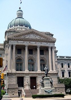
, and the Indiana Statehouse). Along the eastern edge of Indianapolis, US 40 leaves I-465 at Exit 46 and is once again routed onto Washington Street.
East of Indianapolis, US 40 enters Cumberland
Cumberland, Indiana
Cumberland is a town split between Hancock and Marion counties in the U.S. state of Indiana. The population was 5,169 at the 2010 census.-Geography:Cumberland is located at ....
where it takes the name National Road. Paralleling I-70 at a distance of about 3.5 miles (5.6 km), US 40 continues eastward across Indiana, passing through such communities as Greenfield
Greenfield, Indiana
-Demographics:As of the census of 2000, there were 14,600 people, 5,917 households, and 4,017 families residing in the city. The population density was 1,818.0 people per square mile . There were 6,449 housing units at an average density of 803.0 per square mile...
, Knightstown
Knightstown, Indiana
Knightstown is a town in Wayne Township, Henry County, Indiana, along the Big Blue River. The population was 2,182 at the 2010 census. Knightstown is famous for the 1986 movie Hoosiers. The Hoosier Gym was used in the filming of the movie. Knightstown hosts two annual festivals. Jubilee Days held...
, Lewisville
Lewisville, Indiana
Lewisville is a town in Franklin Township, Henry County, Indiana, United States. The population was 366 at the 2010 census.-Geography:Lewisville is located at , along the Flatrock River....
, Straughn
Straughn, Indiana
Straughn is a town in Dudley Township, Henry County, Indiana, United States. The population was 222 at the 2010 census.-Geography:Straughn is located at ....
, Dublin
Dublin, Indiana
Dublin is a town in Jackson Township, Wayne County, Indiana, United States. The population was 790 at the 2010 census.-Geography:Dublin is located at ....
, Mount Auburn
Mount Auburn, Indiana
Mount Auburn is a town in Jackson Township, Wayne County, Indiana, United States. The population was 117 at the 2010 census.-Geography:Mount Auburn is located at ....
, and Cambridge City
Cambridge City, Indiana
Cambridge City is a town in Jackson Township, Wayne County, Indiana, United States. The population was 1,870 at the 2010 census.-Geography:Cambridge City is located at ....
, where it is known by various local names including Washington Street, Main Street, or National Road.
US 40's last stop in Indiana is the city of Richmond
Richmond, Indiana
Richmond is a city largely within Wayne Township, Wayne County, in east central Indiana, United States, which borders Ohio. The city also includes the Richmond Municipal Airport, which is in Boston Township and separated from the rest of the city...
. In Richmond, it passes a statue known as "Madonna of the Trail
Madonna of the Trail
Madonna of the Trail is a series of 12 monuments dedicated to the spirit of pioneer women in the United States. The monuments were commissioned by the National Society of Daughters of the American Revolution...
", one of a series of twelve statues across the U.S. to memorialize women pioneers who made the trek to settle the western U.S.
Manifest Destiny
Manifest Destiny was the 19th century American belief that the United States was destined to expand across the continent. It was used by Democrat-Republicans in the 1840s to justify the war with Mexico; the concept was denounced by Whigs, and fell into disuse after the mid-19th century.Advocates of...
In 1968, a section of US 40 (Main Street) in Richmond was destroyed by a massive gas explosion. This caused a section of Main Street to be closed to automobile traffic, and US 40 was rerouted along North A Street (westbound) and South A Street (eastbound). At the Indiana/Ohio border, US 40 crosses I-70 at exit 156B before entering Ohio.
Ohio
US 40 enters OhioOhio
Ohio is a Midwestern state in the United States. The 34th largest state by area in the U.S.,it is the 7th‑most populous with over 11.5 million residents, containing several major American cities and seven metropolitan areas with populations of 500,000 or more.The state's capital is Columbus...
just to the south of New Paris
New Paris, Ohio
New Paris is a village in Preble County, Ohio, United States. The population was 1,623 at the 2000 census. It is part of the Dayton Metropolitan Statistical Area.- History :The area was in the tribal grounds of the Pottawatomi, Miami and Wyandot Indians....
. The road is always close to the newer I-70 eastward toward Dayton
Dayton, Ohio
Dayton is the 6th largest city in the U.S. state of Ohio and the county seat of Montgomery County, the fifth most populous county in the state. The population was 141,527 at the 2010 census. The Dayton Metropolitan Statistical Area had a population of 841,502 in the 2010 census...
. In Vandalia
Vandalia, Ohio
Vandalia is a city in Montgomery County, Ohio, United States, and a suburb of Dayton. Its population was 15,246 during the 2010 census. The James M. Cox Dayton International Airport is located in the city...
, the road passes to the south of Dayton International Airport
Dayton International Airport
James M. Cox Dayton International Airport , also referred to as simply Dayton International Airport, is a public airport located nine miles north of the central business district of Dayton, a city in Montgomery County, Ohio, United States. The airport is situated in Vandalia and it is owned and...
and crosses I-75
Interstate 75
Interstate 75 is a major north–south Interstate Highway in the Great Lakes and Southeastern regions of the United States. It travels from State Road 826 and State Road 924 in Hialeah, Florida to Sault Ste. Marie, Michigan, at the Ontario, Canada, border...
and the Great Miami River
Great Miami River
The Great Miami River is a tributary of the Ohio River, approximately long, in southwestern Ohio in the United States...
. The road never actually enters Dayton, instead skirting the northern suburbs on the way toward Springfield
Springfield, Ohio
Springfield is a city in the U.S. state of Ohio and the county seat of Clark County. The municipality is located in southwestern Ohio and is situated on the Mad River, Buck Creek and Beaver Creek, approximately west of Columbus and northeast of Dayton. Springfield is home to Wittenberg...
.
In Springfield, US 40 is split between two one-way streets. North Street carries US 40 West and Columbia Street carries US 40 East. The route then shifts on to East Main Street before leaving town to the east, once again as National Road. I-70 crosses again at unincorporated Harmony. US 40 passes just north of London
London, Ohio
London is a city in and the county seat of Madison County, Ohio, United States. Located about southwest of the Ohio capital of Columbus, London was established in 1811 to serve as the county seat. As of the 2000 census, the city population was 8,771, an increase from 7,807 in 1990. It is the...
where it intersects Ohio State Route 56
Ohio State Route 56
State Route 56 is a west–east state highway in southern Ohio. Its western terminus is at SR 29 near Mutual, and its eastern terminus is at SR 682 in Athens.-Cities along route:* London* Mount Sterling* Circleville* Laurelville* South Bloomingville...
and US 42 before heading into West Jefferson
West Jefferson, Ohio
West Jefferson is a village in Madison County, Ohio, United States. The population was 4,331 at the 2000 census. Located along U.S. Route 40, the village has a fairly close relationship with the surrounding township, which include various out-of-corporation-limit neighborhoods West Jefferson is a...
. In West Jefferson, US 40 is designated along Main Street.
Columbus, Ohio
Columbus is the capital of and the largest city in the U.S. state of Ohio. The broader metropolitan area encompasses several counties and is the third largest in Ohio behind those of Cleveland and Cincinnati. Columbus is the third largest city in the American Midwest, and the fifteenth largest city...
metropolitan area, US 40 enters from the west as Broad Street. Among the sites along US 40 in Columbus are the Ohio Statehouse
Ohio Statehouse
The Ohio Statehouse, located in Columbus, Ohio, is the house of government for the state of Ohio. The Greek Revival building houses the Ohio General Assembly and the ceremonial offices of the Governor, Lieutenant Governor, Treasurer, and Auditor....
, the Columbus Museum of Art
Columbus Museum of Art
The Columbus Museum of Art is an art museum located in downtown Columbus, Ohio. Formed in 1878 as the Columbus Gallery of Fine Arts, it was the first art museum to register its charter with the state of Ohio.-Building:...
, and LeVeque Tower
LeVeque Tower
The LeVeque Tower is a 47-story Art Deco-style building in Columbus, Ohio. Located at 50 West Broad Street, it was the tallest building in Columbus from 1927 until 1974 when the Rhodes State Office Tower was completed. The LeVeque Tower is tall, which at the time of its completion made it the...
, the oldest skyscraper in Columbus. In Bexley
Bexley, Ohio
Bexley is an affluent suburban city in Franklin County, Ohio. Founded as a village over a hundred years ago, the City of Bexley is an old, tree-lined suburb of Columbus, the state capital of Ohio, situated on the banks of Alum Creek next to Driving Park and Wolfe Park, just east of the Franklin...
, the route follows Main Street, using Drexel Avenue to get between Broad and Main. US 40 continues as Main Street through Reynoldsburg
Reynoldsburg, Ohio
Reynoldsburg is a city in Fairfield, Franklin, and Licking counties in the U.S. state of Ohio. It is a suburban community in the Columbus, Ohio metropolitan area...
before leaving the Columbus area as National Road yet again.
East of the Columbus metro area, US 40 parallels I-70 at a distance of about 1 miles (2 km), passing through several small towns such as Kirkersville
Kirkersville, Ohio
Kirkersville is a village in Licking County, Ohio, United States, along the South Fork of the Licking River. The population was 520 at the 2000 census.-Geography:Kirkersville is located at ....
and Hebron
Hebron, Ohio
Hebron is a village in Licking County, Ohio, United States. The population was 2,034 at the 2000 census.-Geography:Hebron is located at .According to the United States Census Bureau, the village has a total area of , all of it land....
. In Zanesville
Zanesville, Ohio
Zanesville is a city in and the county seat of Muskingum County, Ohio, United States. The population was 25,586 at the 2000 census.Zanesville was named after Ebenezer Zane, who had constructed Zane's Trace, a pioneer road through present-day Ohio...
, the road becomes Main Street, and at the center of town US 40 begins a concurrency with US 22
U.S. Route 22
U.S. Route 22 is a west–east route and is one of the original United States highways of 1926, running from Cincinnati, Ohio, at US 27, US 42, US 127, and US 52 to Newark, New Jersey, at U.S. Route 1/9 near the Newark Liberty International Airport.US 22 also carries the names of the William...
that carries it to Cambridge
Cambridge, Ohio
As of the census of 2000, there were 11,520 people, 4,924 households, and 2,954 families residing in the city. The population density was 2,055.1 people per square mile . There were 5,585 housing units of an average density of 996.3 per square mile...
. US 40 crosses the Muskingum River
Muskingum River
The Muskingum River is a tributary of the Ohio River, approximately 111 miles long, in southeastern Ohio in the United States. An important commercial route in the 19th century, it flows generally southward through the eastern hill country of Ohio...
in Zanesville on the famous Y-Bridge
Y-Bridge (Zanesville, Ohio)
The Zanesville Y-Bridge is a historic Y-shaped bridge that spans the confluence of the Licking and Muskingum Rivers in downtown Zanesville, Ohio. It carries the traffic of U.S. Route 40 , as well as Linden Avenue....
. Routes 22 and 40 enter Cambridge from the southwest along John Glenn Highway, and split in town; US 40 follows Wheeling Avenue. In Old Washington
Old Washington, Ohio
Old Washington is a village in Guernsey County, Ohio, United States. The population was 265 at the 2000 census.-History:In July 1863, Old Washington was the site of a small engagement during the course of Morgan's Raid...
, US 40 joins I-70 at Exit 186. It leaves I-70 at exit 201 near Morristown
Morristown, Ohio
Morristown is a village in Belmont County, Ohio, United States. It is part of the Wheeling, West Virginia Metropolitan Statistical Area. The population was 299 at the 2000 census.-History:The community's name has also been spelled "Morris Town" in the past....
. The two roads cross paths several times before they both leave Ohio on a pair of bridges
Fort Henry Bridge
The Fort Henry Bridge is a crossing of the Ohio River main channel in Wheeling, West Virginia. The tied-arch bridge carries two lanes in each direction of Interstate 70 , U.S. Route 40 , and US 250. The bridge opened after four years of construction work on September 8, 1955, costing $6.8...
across the Ohio River
Ohio River
The Ohio River is the largest tributary, by volume, of the Mississippi River. At the confluence, the Ohio is even bigger than the Mississippi and, thus, is hydrologically the main stream of the whole river system, including the Allegheny River further upstream...
at Bridgeport
Bridgeport, Ohio
Bridgeport is a village in Belmont County, Ohio, United States. It is part of the Wheeling, West Virginia Metropolitan Statistical Area. The population was 1,831 at the 2010 census...
.
The now-decommissioned Ohio State Route 440 ran along old US 40 in places where US 40 had been shifted onto I-70.
West Virginia
U.S. 40 is only 10 miles (16.1 km) long as it passes through West Virginia. Much of the highway has been moved from the old National RoadNational Road
The National Road or Cumberland Road was the first major improved highway in the United States to be built by the federal government. Construction began heading west in 1811 at Cumberland, Maryland, on the Potomac River. It crossed the Allegheny Mountains and southwestern Pennsylvania, reaching...
path to I-70.
Pennsylvania
West Alexander, Pennsylvania
West Alexander is an unincorporated community in Washington County, Pennsylvania, United States. The population was 320 at the 2000 census, at which time it was a borough...
. It closely parallels I-70 from West Virginia until it reaches Washington
Washington, Pennsylvania
Washington is a city in and the county seat of Washington County, Pennsylvania, United States, within the Pittsburgh Metro Area in the southwestern part of the state...
where it follows Jefferson Avenue and Maiden Street. In Washington, US 40 passes to the south of Washington & Jefferson College
Washington & Jefferson College
Washington & Jefferson College, also known as W & J College or W&J, is a private liberal arts college in Washington, Pennsylvania, in the United States, which is south of Pittsburgh...
. Following Maiden Street out of town, the road turns southeast toward the town of California
California, Pennsylvania
California is a borough in Washington County, Pennsylvania, United States, along the Monongahela River. The population was 5,274 as of the 2000 census. California is the home of California University of Pennsylvania. Founded in 1849, the borough was named for the territory of California following...
. A short limited access highway in California and West Brownsville
West Brownsville, Pennsylvania
West Brownsville is a borough in Washington County, Pennsylvania, United States. The population was 1,075 at the 2000 census.-Geography:West Brownsville is located at ....
provides an approach to the Lane Bane Bridge
Lane Bane Bridge
The Lane Bane Bridge is a truss bridge that carries vehicular traffic across the Monongahela River between Brownsville, Pennsylvania and West Brownsville, Pennsylvania. The high level bridge was constructed in 1960 and was originally deigned to be part of the Mon-Fayette Expressway...
across the Monongahela River
Monongahela River
The Monongahela River is a river on the Allegheny Plateau in north-central West Virginia and southwestern Pennsylvania in the United States...
. From here, the road continues southeast to Uniontown
Uniontown, Pennsylvania
Uniontown is a city in Fayette County, Pennsylvania, southeast of Pittsburgh and part of the Pittsburgh Metro Area. Population in 1900, 7,344; in 1910, 13,344; in 1920, 15,692; and in 1940, 21,819. The population was 10,372 at the 2010 census...
.
US 40 bypasses Uniontown along a limited access highway that also carries US 119
U.S. Route 119
U.S. Route 119, commonly abbreviated as US 119, is a spur of US 19. It is a north–south route that was an original United States highway of 1926. It is often referred to as Corridor G east of US 23 and KY 80 in Kentucky to Interstate 64 at Charleston, West Virginia.- Kentucky :US 119 is a two...
. An old alignment through Uniontown is signed as "Business US 40." Southeast of Uniontown, travellers pass the Fort Necessity National Battlefield
Fort Necessity National Battlefield
Fort Necessity National Battlefield is a National Battlefield Site in Fayette County, Pennsylvania, United States, which preserves elements of the Battle of Fort Necessity...
. It follows Braddock Road southeast of Uniontown, crossing the Youghiogheny River Lake
Youghiogheny River Lake
The Youghiogheny River Lake is a flood control reservoir in southwestern Pennsylvania and western Maryland. It was formed in 1944 by the damming of the Youghiogheny River upstream from Confluence, Pennsylvania....
on a bridge completed in 2006. US 40 leaves Pennsylvania at Addison
Addison, Pennsylvania
Addison is a borough in Somerset County, Pennsylvania, United States. It is part of the Johnstown, Pennsylvania Metropolitan Statistical Area. The population was 214 at the 2000 census.-Geography:...
Maryland
US 40 enters MarylandMaryland
Maryland is a U.S. state located in the Mid Atlantic region of the United States, bordering Virginia, West Virginia, and the District of Columbia to its south and west; Pennsylvania to its north; and Delaware to its east...
from Pennsylvania near Grantsville
Grantsville, Maryland
Grantsville is a town in Garrett County, Maryland, United States. The population was 619 at the 2000 census.-History:Grantsville, 1/2 mile west of the Casselman River, began as a small Amish and Mennonite settlement, called Tomlinson's or Little Crossing, along Braddock rd., which wound westward...
in the western part of the state
Western Maryland
Western Maryland is the portion of the U.S. state of Maryland that consists of Frederick, Washington, Allegany, and Garrett counties. The region is bounded by the Mason-Dixon line to the north, Preston County, West Virginia to the west, and the Potomac River to the south. There is dispute over the...
. Here, and through most of the state, it is known as National Pike. US 40 leaves National Pike shortly after entering Maryland from the northwest and merges with I-68
Interstate 68
Interstate 68 is a Interstate highway in the U.S. states of West Virginia and Maryland, connecting in Morgantown to in Hancock. is also Corridor E of the Appalachian Development Highway System. From 1965 until the freeway's construction was completed in 1991, it was designated as...
and US 219
U.S. Route 219
U.S. Route 219 is a spur of U.S. Route 19. It runs for from West Seneca, New York at an interchange with Interstate 90, to Rich Creek, Virginia, intersecting at U.S. Route 460. U.S. 219 is found in New York, Pennsylvania, Maryland, West Virginia, and Virginia...
at exit 14B. The old alignment of US 40, still known as National Pike, is signed through much of the western part of the state as either "Scenic US 40" or "Alternate US 40". US 219 leaves the three-way concurrency at exit 22, but US 40 and I-68 remain on the same pavement through Frostburg
Frostburg, Maryland
Frostburg is a city in Allegany County, Maryland, United States located at the head of the Georges Creek Valley. It is part of the Cumberland, MD-WV Metropolitan Statistical Area. The population was 7,873 at the 2000 census...
and Cumberland
Cumberland, Maryland
Cumberland is a city in the far western, Appalachian portion of Maryland, United States. It is the county seat of Allegany County, and the primary city of the Cumberland, MD-WV Metropolitan Statistical Area. At the 2010 census, the city had a population of 20,859, and the metropolitan area had a...
.
East of Cumberland, the old National Pike (formerly US 40) carries the MD 144
Maryland Route 144
Maryland Route 144 is a collection of state highways in the U.S. state of Maryland. These highways are sections of old alignment of U.S. Route 40 between Cumberland and Baltimore...
designation. The I-68/US 40 roadway passes through a 340 feet (103.6 m) deep cut in Sideling Hill
Sideling Hill
Sideling Hill is a long, steep, narrow mountain ridge in the Ridge-and-Valley physiographic province of the Appalachian Mountains, located in Washington County in western Maryland and adjacent West Virginia and Pennsylvania, USA...
. Just to the east of the cut is the Sideling Hill Exhibit Center, a museum that highlights Western Maryland geology. At Hancock
Hancock, Maryland
Hancock is a town in Washington County, Maryland, United States. The population was 1,725 at the 2000 census. The Western Maryland community is notable for being located at the narrowest part of the state...
, where the state of Maryland narrows to less than two miles (3 km) wide, I-68 ends, and US 40 merges onto I-70 at exit 1. The two routes closely follow the course of the Chesapeake and Ohio Canal
Chesapeake and Ohio Canal
The Chesapeake and Ohio Canal, abbreviated as the C&O Canal, and occasionally referred to as the "Grand Old Ditch," operated from 1831 until 1924 parallel to the Potomac River in Maryland from Cumberland, Maryland to Washington, D.C. The total length of the canal is about . The elevation change of...
and the Potomac River
Potomac River
The Potomac River flows into the Chesapeake Bay, located along the mid-Atlantic coast of the United States. The river is approximately long, with a drainage area of about 14,700 square miles...
for several miles before US 40 leaves the Interstate at exit 9. US 40 passes directly through the center of Hagerstown
Hagerstown, Maryland
Hagerstown is a city in northwestern Maryland, United States. It is the county seat of Washington County, and, by many definitions, the largest city in a region known as Western Maryland. The population of Hagerstown city proper at the 2010 census was 39,662, and the population of the...
using Washington Avenue (eastbound) and Franklin Street (westbound). Heading southeast out of Hagerstown, US 40 diverges into two separate routes, US 40 and US 40 Alt. US 40 parallels I-70, its longtime travel partner, crossing it at exit 32 near Greenbrier State Park
Greenbrier State Park
Greenbrier State Park is a Maryland state park on South Mountain in Washington County.-External links:* - official site...
on the Baltimore National Pike alignment. US 40 Alt heads southeast on the Old National Pike alignment through Boonsboro
Boonsboro, Maryland
Boonsboro is a town in Washington County, Maryland, United States, located at the foot of South Mountain. It nearly borders Frederick County and is proximate to the Antietam National Battlefield...
, crossing South Mountain
South Mountain (Maryland and Pennsylvania)
South Mountain is the northern extension of the Blue Ridge Mountain range in Maryland and Pennsylvania. From the Potomac River near Knoxville, Maryland in the south, to Dillsburg, Pennsylvania in the north, the long range separates the Hagerstown and Cumberland valleys from the Piedmont regions of...
at Turner's Gap
Turner's Gap
Turner's Gap is a wind gap in the South Mountain Range of the Blue Ridge Mountains, located in Frederick County and Washington County, Maryland. The gap is traversed by U.S. Route 40 Alt, the Old National Pike. The Appalachian Trail also crosses the gap....
. The two routes converge just west of Frederick.
Frederick, Maryland
Frederick is a city in north-central Maryland. It is the county seat of Frederick County, the largest county by area in the state of Maryland. Frederick is an outlying community of the Washington-Arlington-Alexandria, DC-VA-MD-WV Metropolitan Statistical Area, which is part of a greater...
, US 40 uses Patrick Street before merging onto the US 15
U.S. Route 15 in Maryland
U.S. Route 15 is a part of the U.S. Highway System that runs from Walterboro, South Carolina to Painted Post, New York. In Maryland, the highway runs from the Virginia state line at the Potomac River in Point of Rocks north to the Pennsylvania state line near Emmitsburg. US 15 is...
expressway for a short distance. It leaves US 15 and rejoins I-70 on the outskirts of Frederick. MD 144 once again takes over along the old alignment of US 40.
US 40 leaves I-70 for the final time upon entering the western suburbs of Baltimore, once again as Baltimore National Pike. The route passes through Patapsco Valley State Park
Patapsco Valley State Park
Patapsco Valley State Park is located in Maryland, USA and extends along 32 miles of the Patapsco River, encompassing and five developed recreational areas. Recreational opportunities include hiking, fishing, camping, canoeing, horseback riding and mountain bike trails, as well as picnicking for...
north of Ellicott City
Ellicott City, Maryland
Ellicott City is an unincorporated community and census-designated place in Howard County, Maryland, United States. It is part of the Baltimore-Washington Metropolitan Area. The population was 65,834 at the 2010 census. It is the county seat of Howard County...
and enters the Baltimore city limits along Edmondson Avenue. East of Gwynns Falls Park, US 40 becomes Franklin Street, and becomes an expressway (formerly I-170
Interstate 170 (Maryland)
Interstate 170 is the former designation for a freeway in Baltimore, Maryland that is now designated as part of US 40...
) for a short distance between Pulaski Street and Martin Luther King Jr. Boulevard. Through this area, an alignment called "Truck US 40" diverts larger vehicles onto an alternate route. US 40 passes through the Mount Vernon neighborhood and a few blocks from Baltimore's Washington Monument
Washington Monument (Baltimore)
The Washington Monument in the elegant Mount Vernon neighborhood of Baltimore, Maryland was the first architectural monument planned to honor George Washington.-History:...
. After crossing the Jones Falls Expressway (I-83
Interstate 83
Interstate 83 is an Interstate Highway in the eastern United States. Its southern terminus is in Baltimore, Maryland at the Fayette Street exit; its northern terminus is in Harrisburg, Pennsylvania at Interstate 81....
), US 40 follows Orleans Street, and finally becomes the Pulaski Highway as it leaves Baltimore to the northeast.
US 40, for the entire length of Pulaski Highway, closely parallels I-95
Interstate 95 in Maryland
Interstate 95 in Maryland is a major highway that runs diagonally from northeast to southwest, from Maryland's border with Delaware, to the Woodrow Wilson Bridge, briefly entering the District of Columbia before reaching Virginia...
. Pulaski Highway passes through Gunpowder Falls State Park
Gunpowder Falls State Park
Gunpowder Falls State Park is an park in northwestern Baltimore County and eastern Harford County, Maryland. It is primarily made up of the stream valleys of the Big and Little Gunpowder Falls and the Gunpowder River, and boasts over 100 miles of trails. All areas of the park are convenient to the...
near Joppa
Joppa, Maryland
Joppa, Maryland in Harford County, Maryland is now a planning region for the county, but there was originally a town at the center called Joppa. Joppa was founded as a British colonial settlement in the early 18th century, and takes its name from the biblical town of Joppa .The town of Joppa on...
and the Aberdeen Proving Ground
Aberdeen Proving Ground
Aberdeen Proving Ground is a United States Army facility located near Aberdeen, Maryland, . Part of the facility is a census-designated place , which had a population of 3,116 at the 2000 census.- History :...
. Between Havre de Grace
Havre de Grace, Maryland
Havre de Grace is a city in Harford County, Maryland, United States. Located at the mouth of the Susquehanna River and the head of the Chesapeake Bay, Havre de Grace is named after the port city of Le Havre, France, which was first named Le Havre de Grâce, meaning in French "Harbor of Grace." As...
and Perryville
Perryville, Maryland
Perryville is a town in Cecil County, Maryland, United States. The population was 3,672 at the 2000 census. The town is located off Interstate 95, on the north side of the mouth of the Susquehanna River.-History:...
it crosses the Susquehanna River
Susquehanna River
The Susquehanna River is a river located in the northeastern United States. At long, it is the longest river on the American east coast that drains into the Atlantic Ocean, and with its watershed it is the 16th largest river in the United States, and the longest river in the continental United...
on the Thomas J. Hatem Memorial Bridge
Thomas J. Hatem Memorial Bridge
The Thomas J. Hatem Memorial Bridge is a bridge carrying the traffic across the Susquehanna River on U.S. Route 40 between Havre de Grace and Perryville via Garrett Island in northeast Maryland. It is the oldest of the eight toll facilities operated and maintained by the Maryland Transportation...
. US 40 leaves Maryland in Elkton
Elkton, Maryland
The town of Elkton is the county seat of Cecil County, Maryland, United States. The population was 11,893 as of the 2000 census and 14,842 according to current July 2008 census estimates. It is the county seat of Cecil County...
, crossing the border into Delaware.
Delaware
US 40 crosses DelawareDelaware
Delaware is a U.S. state located on the Atlantic Coast in the Mid-Atlantic region of the United States. It is bordered to the south and west by Maryland, and to the north by Pennsylvania...
for about 15 miles (24 km). Entering the state from Maryland in Glasgow
Glasgow, Delaware
Glasgow is a census-designated place in New Castle County, Delaware, United States. The population was 12,840 at the 2000 census.-Geography:Glasgow is located at ....
, it continues along the Pulaski Highway. It crosses Delaware Route 1 in the community of Bear
Bear, Delaware
Bear is a census-designated place in New Castle County, Delaware, United States. The population was 17,593 at the 2000 census.Originally a small crossroads in a rural area south of Wilmington, the area supported small farms growing mainly corn and cattle...
before merging with US 13
U.S. Route 13
U.S. Route 13 is a north–south U.S. highway established in 1926 that runs for from Interstate 95 just north of Fayetteville, North Carolina to the northeastern suburbs of Philadelphia, Pennsylvania, in Morrisville. In all, it traverses five states in the Atlantic coastal plain region,...
and the Dupont Highway in Midvale. The concurrent routes pass the New Castle Airport
New Castle Airport
New Castle Airport , also known as the New Castle County Airport, is a public airport located in unincorporated New Castle County, Delaware, United States and four miles south of the central business district of the city of Wilmington....
and US 40 leaves to join I-295
Interstate 295 (Delaware-New Jersey)
Interstate 295 in New Jersey and Delaware is an auxiliary Interstate Highway, designated as a bypass around Philadelphia, Pennsylvania. The route begins at a junction with Interstate 95 south of Wilmington, Delaware, and runs to another junction with I-95 north of Trenton, New Jersey...
near Wilmington Manor
Wilmington Manor, Delaware
Wilmington Manor is a census-designated place in north-eastern New Castle County, Delaware, United States. The population was 8,262 at the 2000 census.-Geography:Wilmington Manor is located at...
. US 40, along with I-295, uses the Delaware Memorial Bridge
Delaware Memorial Bridge
The Delaware Memorial Bridge is a set of twin suspension bridges crossing the Delaware River. The toll bridges carry Interstate 295 and U.S. Route 40 between Delaware and New Jersey...
to cross the Delaware River
Delaware River
The Delaware River is a major river on the Atlantic coast of the United States.A Dutch expedition led by Henry Hudson in 1609 first mapped the river. The river was christened the South River in the New Netherland colony that followed, in contrast to the North River, as the Hudson River was then...
into New Jersey.
New Jersey
New Jersey
New Jersey is a state in the Northeastern and Middle Atlantic regions of the United States. , its population was 8,791,894. It is bordered on the north and east by the state of New York, on the southeast and south by the Atlantic Ocean, on the west by Pennsylvania and on the southwest by Delaware...
in Deepwater, New Jersey
Deepwater, New Jersey
Deepwater is a community in Pennsville, in Salem County, New Jersey, lying at the east end of the Delaware Memorial Bridge. Deepwater is the location of the United States Postal Service area covering ZIP code 08023...
along with I-295. US 40 briefly joins the New Jersey Turnpike
New Jersey Turnpike
The New Jersey Turnpike is a toll road in New Jersey, maintained by the New Jersey Turnpike Authority. According to the International Bridge, Tunnel and Turnpike Association, the Turnpike is the nation's sixth-busiest toll road and is among one of the most heavily traveled highways in the United...
, and exits to the south of the toll booth
Toll house
A tollhouse or toll house is a building with accommodation for a toll collector, beside a tollgate on a toll road or canal. Many tollhouses were built by turnpike trusts in England, Wales and Scotland during the 18th and early 19th centuries...
s. The route follows Wiley Road, parallel to the Turnpike, before joining Harding Highway in Carneys Point
Carneys Point Township, New Jersey
Carneys Point Township is a Township in Salem County, New Jersey, United States. As of the 2010 United States Census, the township population was 8,049....
. US 40 will be Harding Highway through most of South Jersey
South Jersey
South Jersey comprises the southern portions of the U.S. state of New Jersey between the lower Delaware River and the Atlantic Ocean. The designation is a colloquial one, reflecting not only geographical but perceived cultural differences from the northern part of the state, with no official...
. Northeast of where US 40 joins it, Harding Highway carries the NJ 48 designation; though this was once part of US 40 as well.
It enters the borough
Borough
A borough is an administrative division in various countries. In principle, the term borough designates a self-governing township although, in practice, official use of the term varies widely....
of Woodstown
Woodstown, New Jersey
Woodstown is a Borough in Salem County, New Jersey, United States. As of the United States 2000 Census, the borough population was 3,136.Woodstown was established on July 26, 1882, from portions of Pilesgrove Township based on the results of a referendum held that same day...
as a concurrency with NJ 45 along West Avenue; it leaves town heading southeast. In Upper Pittsgrove Township
Upper Pittsgrove Township, New Jersey
Upper Pittsgrove Township is a Township in Salem County, New Jersey, United States. As of the 2000 United States Census, the township population was 3,468.Upper Pittsgrove Township was incorporated on March 10, 1846, from portions of Pittsgrove Township...
, the road changes names to the Pole Tavern-Elmer Road. Passing through Elmer
Elmer, New Jersey
Elmer is a Borough in Salem County, New Jersey, United States. As of the United States 2010 Census, the borough population was 1,395, making it the 520th largest city in New Jersey....
it becomes Chestnut St. and then Elmer-Malaga Road. In Malaga
Malaga, New Jersey
Malaga is an unincorporated area located within Franklin Township, in Gloucester County, New Jersey, United States. The area is served as United States Postal Service ZIP Code 08328....
it uses Delsea Drive. The route bypasses the city of Vineland
Vineland, New Jersey
Vineland is a city in Cumberland County, New Jersey, United States. As of the 2010 United States Census, the city had a total population of 60,724...
to the northeast, and becomes Cape May Avenue in Hamilton Township
Hamilton Township
-Indiana:* Hamilton Township, Delaware County, Indiana* Hamilton Township, Jackson County, Indiana* Hamilton Township, Sullivan County, Indiana-Iowa:* Hamilton Township, Decatur County, Iowa* Hamilton Township, Franklin County, Iowa...
, where it runs concurrent with NJ 50. In Mays Landing
Mays Landing, New Jersey
Mays Landing is a census-designated place located within Hamilton Township, in Atlantic County, New Jersey. As of the United States 2000 Census, the CDP population was 2,321. It is the county seat of Atlantic County...
US 40 uses Main Street.
US 40 merges with US 322
U.S. Route 322 in New Jersey
U.S. Route 322 is a U.S. highway running from Cleveland, Ohio east to Atlantic City, New Jersey. The easternmost segment of the route in New Jersey runs from the Commodore Barry Bridge over the Delaware River in Logan Township, Glocuester County, where it continues into Chester, Pennsylvania,...
and the Black Horse Pike
Black Horse Pike
The Black Horse Pike is a designation used for a number of different roadways that had been part of a historic route connecting the Camden area to the area of Atlantic City, New Jersey. Roadways now bearing the Black Horse Pike designation include portions of New Jersey Route 168, New Jersey Route...
in McKee City
McKee City, New Jersey
McKee City is an unincorporated community within the Mays Landing section of Hamilton Township, Atlantic County, New Jersey. The community was named after Colonel John McKee , a Civil War veteran...
. The two routes enter Atlantic City
Atlantic City, New Jersey
Atlantic City is a city in Atlantic County, New Jersey, United States, and a nationally renowned resort city for gambling, shopping and fine dining. The city also served as the inspiration for the American version of the board game Monopoly. Atlantic City is located on Absecon Island on the coast...
along Albany Boulevard and pass the Atlantic City Airport
Bader Field
Bader Field , also known as Atlantic City Municipal Airport, was a city-owned public-use general aviation airport located in west of Atlantic City, in Atlantic County, New Jersey, United States. It was approximately one mile from the terminus of U.S. Route 40 and U.S. Route 322. Bader Field...
. US 40 and US 322 both reach their eastern terminus at the intersection of Albany Boulevard and Ventnor Avenue.
Early roads
US 40's history can be traced back several centuries. Several well established Native American footpaths, including Nemacolin's PathNemacolin's Path
thumb|450px|[[Braddock's Road|General Braddock's March]] follows or parallel's Chief Nemacolin's Trail from the Potomac River to the Monogahela. The wagon negotiable route from the summit to [[Redstone Creek]] was bypassed by Braddock...
and Mingo Path in the Maryland-Pennsylvania area, followed similar alignments to US 40. Early American colonists established roads, some following the established Native American paths, that would later serve as US 40. These included a segment of post road between Wilmington, Delaware
Wilmington, Delaware
Wilmington is the largest city in the state of Delaware, United States, and is located at the confluence of the Christina River and Brandywine Creek, near where the Christina flows into the Delaware River. It is the county seat of New Castle County and one of the major cities in the Delaware Valley...
, and Baltimore, Maryland. In 1755, during the French and Indian Wars
French and Indian Wars
The French and Indian Wars is a name used in the United States for a series of conflicts lasting 74 years in North America that represented colonial events related to the European dynastic wars...
, General Edward Braddock blazed a trail en route to capture Fort Duquesne
Fort Duquesne
Fort Duquesne was a fort established by the French in 1754, at the junction of the Allegheny and Monongahela rivers in what is now downtown Pittsburgh in the state of Pennsylvania....
(modern Pittsburgh, Pennsylvania
Pittsburgh, Pennsylvania
Pittsburgh is the second-largest city in the US Commonwealth of Pennsylvania and the county seat of Allegheny County. Regionally, it anchors the largest urban area of Appalachia and the Ohio River Valley, and nationally, it is the 22nd-largest urban area in the United States...
). US 40 closely follows this route between Cumberland, Maryland
Cumberland, Maryland
Cumberland is a city in the far western, Appalachian portion of Maryland, United States. It is the county seat of Allegany County, and the primary city of the Cumberland, MD-WV Metropolitan Statistical Area. At the 2010 census, the city had a population of 20,859, and the metropolitan area had a...
and Uniontown, Pennsylvania
Uniontown, Pennsylvania
Uniontown is a city in Fayette County, Pennsylvania, southeast of Pittsburgh and part of the Pittsburgh Metro Area. Population in 1900, 7,344; in 1910, 13,344; in 1920, 15,692; and in 1940, 21,819. The population was 10,372 at the 2010 census...
.
Early in the history of the U.S., the State of Maryland established a network of turnpikes
Toll road
A toll road is a privately or publicly built road for which a driver pays a toll for use. Structures for which tolls are charged include toll bridges and toll tunnels. Non-toll roads are financed using other sources of revenue, most typically fuel tax or general tax funds...
for long-distance travel. Three of these would later serve as part of US 40: the Baltimore and Havre de Grace
Havre de Grace, Maryland
Havre de Grace is a city in Harford County, Maryland, United States. Located at the mouth of the Susquehanna River and the head of the Chesapeake Bay, Havre de Grace is named after the port city of Le Havre, France, which was first named Le Havre de Grâce, meaning in French "Harbor of Grace." As...
Turnpike, the Baltimore and Frederick
Frederick, Maryland
Frederick is a city in north-central Maryland. It is the county seat of Frederick County, the largest county by area in the state of Maryland. Frederick is an outlying community of the Washington-Arlington-Alexandria, DC-VA-MD-WV Metropolitan Statistical Area, which is part of a greater...
Turnpike, and Bank Road. Colonel Ebenezer Zane
Ebenezer Zane
Ebenezer Zane was an American pioneer, road builder and land speculator. Born in what is now Moorefield, West Virginia , Zane established the settlement known as Fort Henry in Wheeling, Virginia on the Ohio River...
(for whom Zanesville, Ohio
Zanesville, Ohio
Zanesville is a city in and the county seat of Muskingum County, Ohio, United States. The population was 25,586 at the 2000 census.Zanesville was named after Ebenezer Zane, who had constructed Zane's Trace, a pioneer road through present-day Ohio...
was named) blazed some of the first trails across the Ohio wilderness in the last years of the 18th century. Zane's Trace
Zane's Trace
Zane's Trace is a frontier road constructed under the direction of Col. Ebenezer Zane through the Northwest Territory of the United States, in what is now the state of Ohio. Many portions were based on traditional Native American trails...
, as his road was called, stretched from Wheeling, West Virginia
Wheeling, West Virginia
Wheeling is a city in Ohio and Marshall counties in the U.S. state of West Virginia; it is the county seat of Ohio County. Wheeling is the principal city of the Wheeling Metropolitan Statistical Area...
, to Maysville, Ohio. With some minor alignment differences, US 40 closely matches the segment from Wheeling to Zanesville.
Between the cities of Lawrence
Lawrence, Kansas
Lawrence is the sixth largest city in the U.S. State of Kansas and the county seat of Douglas County. Located in northeastern Kansas, Lawrence is the anchor city of the Lawrence, Kansas, Metropolitan Statistical Area, which encompasses all of Douglas County...
and Topeka, Kansas
Topeka, Kansas
Topeka |Kansa]]: Tó Pee Kuh) is the capital city of the U.S. state of Kansas and the county seat of Shawnee County. It is situated along the Kansas River in the central part of Shawnee County, located in northeast Kansas, in the Central United States. As of the 2010 census, the city population was...
, US 40 follows the path of the Oregon Trail
Oregon Trail
The Oregon Trail is a historic east-west wagon route that connected the Missouri River to valleys in Oregon and locations in between.After 1840 steam-powered riverboats and steamboats traversing up and down the Ohio, Mississippi and Missouri rivers sped settlement and development in the flat...
. During the 19th century, the Oregon Trail served as a major thoroughfare for people emigrating to the Pacific Northwest
Pacific Northwest
The Pacific Northwest is a region in northwestern North America, bounded by the Pacific Ocean to the west and, loosely, by the Rocky Mountains on the east. Definitions of the region vary and there is no commonly agreed upon boundary, even among Pacific Northwesterners. A common concept of the...
. Between 1850 and 1852, some 65,000-70,000 people traveled the trail.
Most of the western section of US 40 follows the former route of Victory Highway
Victory Highway
The Victory Highway was an auto trail across the United States between New York City and San Francisco, roughly equivalent to the present U.S. Route 40.-History:...
, a road that once linked Kansas City to San Francisco. The road was named as a memorial to fallen World War I veterans. Other than two sections (one in California and one in Kansas/Colorado) most of the original route of US 40 west of Kansas City used Victory Highway. According to a 1926 guide published about the Victory Highway, it was the fastest route between San Francisco and Salt Lake City, allowing travellers to complete the 784 miles (1,262 km) trip "comfortably and in high gear in from 3 to 4 days." Controversy over the routing of US 40 over the Victory Highway led to a "divided route", with US 40S following the Victory Highway and US 40N taking a more northerly route.
National Road
Thomas Jefferson
Thomas Jefferson was the principal author of the United States Declaration of Independence and the Statute of Virginia for Religious Freedom , the third President of the United States and founder of the University of Virginia...
signed into law an act of Congress establishing a National Road to connect the waters of the Atlantic Ocean
Atlantic Ocean
The Atlantic Ocean is the second-largest of the world's oceanic divisions. With a total area of about , it covers approximately 20% of the Earth's surface and about 26% of its water surface area...
with the Ohio River
Ohio River
The Ohio River is the largest tributary, by volume, of the Mississippi River. At the confluence, the Ohio is even bigger than the Mississippi and, thus, is hydrologically the main stream of the whole river system, including the Allegheny River further upstream...
. The law mentions Baltimore as its eastern terminus; but the route used established Maryland turnpikes east of Cumberland. A new road was constructed from Cumberland to Wheeling, West Virginia, and later extended across the states of Ohio
Ohio
Ohio is a Midwestern state in the United States. The 34th largest state by area in the U.S.,it is the 7th‑most populous with over 11.5 million residents, containing several major American cities and seven metropolitan areas with populations of 500,000 or more.The state's capital is Columbus...
, Indiana
Indiana
Indiana is a US state, admitted to the United States as the 19th on December 11, 1816. It is located in the Midwestern United States and Great Lakes Region. With 6,483,802 residents, the state is ranked 15th in population and 16th in population density. Indiana is ranked 38th in land area and is...
, and Illinois
Illinois
Illinois is the fifth-most populous state of the United States of America, and is often noted for being a microcosm of the entire country. With Chicago in the northeast, small industrial cities and great agricultural productivity in central and northern Illinois, and natural resources like coal,...
. Segments of the National Road used Braddock's Road and Zane's Trace. Plans to extend the road to Missouri
Missouri
Missouri is a US state located in the Midwestern United States, bordered by Iowa, Illinois, Kentucky, Tennessee, Arkansas, Oklahoma, Kansas and Nebraska. With a 2010 population of 5,988,927, Missouri is the 18th most populous state in the nation and the fifth most populous in the Midwest. It...
were never completed. The farthest western terminus for the National Road was the Old State House in Vandalia, Illinois
Vandalia, Illinois
Vandalia is a city in Fayette County, Illinois, United States, northeast of St. Louis, on the Kaskaskia River. From 1819 to 1839 it served as the state capital of Illinois. Vandalia was the western terminus of the National Road. Today it is the county seat of Fayette County and the home of the...
.
The National Road was absorbed into the National Old Trails Ocean-to-Ocean highway, a route from New York, New York, to Los Angeles, California
Los Angeles, California
Los Angeles , with a population at the 2010 United States Census of 3,792,621, is the most populous city in California, USA and the second most populous in the United States, after New York City. It has an area of , and is located in Southern California...
in the early 20th century. During the planning phases of what would become the U.S. Federal Highway System, the National Road was originally to be US 1. This would have disrupted the organized numbering system, however, and the National Road became US 40 in the original 1925 plan for U.S. Routes. To this day, many places still name US 40 "National Road", even where the alignment was moved from the original road. Besides US 40, much of the National Road is paralleled by segments of Interstates 68
Interstate 68
Interstate 68 is a Interstate highway in the U.S. states of West Virginia and Maryland, connecting in Morgantown to in Hancock. is also Corridor E of the Appalachian Development Highway System. From 1965 until the freeway's construction was completed in 1991, it was designated as...
and 70
Interstate 70
Interstate 70 is an Interstate Highway in the United States that runs from Interstate 15 near Cove Fort, Utah, to a Park and Ride near Baltimore, Maryland. It was the first Interstate Highway project in the United States. I-70 approximately traces the path of U.S. Route 40 east of the Rocky...
.
California
The former route of US 40 in California generally runs parallel to modern Interstate 80. In Contra Costa County it is San Pablo Avenue, now signed as California State Route 123California State Route 123
State Route 123 is a state highway in the U.S. state of California in the San Francisco Bay Area. Named San Pablo Avenue for virtually its entire length, SR 123 is a major north–south state highway along the flats of the urban East Bay in the U.S. state of California...
. Portions of Historic Route 40 exist in Vallejo, along Broadway. In Cordelia and Suisun City, the original route is along Cordelia Road. It is also signed at as a historic route. The original route is preserved as Texas Street in Fairfield
Fairfield, California
Fairfield is a city located in Solano County in Northern California, USA. It is generally considered the midpoint between the cities of San Francisco and Sacramento, approximately from the city center of both cities, approximately from the city center of Oakland, less than from Napa Valley, 18...
. In Vacaville
Vacaville, California
Vacaville, California is a city located in the northeastern portion of the San Francisco Bay Area in Solano County. The city is nearly half way between Sacramento and San Francisco on I-80. It sits approximately from Sacramento, and from San Francisco...
the highway is preserved as Monte Vista Avenue. In Davis
Davis, California
Davis is a city in Yolo County, California, United States. It is part of the Sacramento–Arden-Arcade–Roseville Metropolitan Statistical Area...
, the highway is now Russell Boulevard, the main street through downtown Davis. In Sacramento
Sacramento, California
Sacramento is the capital city of the U.S. state of California and the county seat of Sacramento County. It is located at the confluence of the Sacramento River and the American River in the northern portion of California's expansive Central Valley. With a population of 466,488 at the 2010 census,...
the highway followed the routes of modern Capitol Avenue, SR 160
California State Route 160
State Route 160 is a state highway in the U.S. state of California consisting of two sections. The longer, southern, section is a scenic highway through the alluvial plain of the Sacramento River, linking SR 4 in Antioch with Sacramento via the Antioch Bridge...
and Auburn Boulevard. Through the Sierra Nevada many portions are still drivable, crossing I-80. Portions still drivable include Applegate Road in Applegate
Applegate, California
Applegate is an unincorporated community in Placer County, California. Applegate is located south-southwest of Colfax.It lies at an elevation of 2005 feet . Its ZIP code is 95703 and its area code 530....
, Hampshire Rocks Road in a rural area near Cisco, and Donner Pass Road over Donner Pass
Donner Pass
Donner Pass is a mountain pass in the northern Sierra Nevada, located above Donner Lake about nine miles west of Truckee, California. It has a steep approach from the east and a gradual approach from the west....
and into Truckee
Truckee, California
Truckee is an incorporated town in Nevada County, California, United States. The population was 16,180 at the 2010 census, up from 13,864 at the 2000 census.-Name:...
. Between Truckee and the Nevada state line, the former route of US 40 is mostly visible from the freeway, but not drivable as a contiguous route. Portions accessible include Glenshire Drive, Hirshdale Road and Floriston Way.
Alternate U.S. Route 40
From 1954 to 1964, an alternate route U.S. 40 was available especially during winter to avoid Donner PassDonner Pass
Donner Pass is a mountain pass in the northern Sierra Nevada, located above Donner Lake about nine miles west of Truckee, California. It has a steep approach from the east and a gradual approach from the west....
. Donner Pass, elevation 7,085 ft (2,160 m), was closed through many weeks in the winter months. This alternate route used Beckwourth Pass
Beckwourth Pass
Beckwourth Pass is the lowest Sierra Crest mountain pass and is located at the Sierra Valley's eastern edge near Chilcoot-Vinton, Plumas County, California. Beckwourth Pass is east of Beckwourth, California, in the Sierra Nevada, and is northwest of Reno, Nevada. The pass carries California State...
, elevation of 5,221 ft (1,591 m). Since Beckwourth Pass was nearly 2,000 ft, (610 m), lower than Donner Pass, it could be kept open for a much longer time during the year. ALT U.S. 40 parted the main track of U.S. 40 near Davis
Davis, California
Davis is a city in Yolo County, California, United States. It is part of the Sacramento–Arden-Arcade–Roseville Metropolitan Statistical Area...
and ran north along what was then signed as U.S. Route 99W into Woodland
Woodland, California
Woodland is the county seat of Yolo County, California, located approximately northwest of Sacramento, and is a part of the Sacramento - Arden-Arcade - Roseville Metropolitan Statistical Area. The population was 55,468 at the 2010 census.Woodland's origins trace back to 1850 when California...
. From Woodland, ALT U.S. 40 ran north along California State Route 24
California State Route 24
State Route 24 in the U.S. state of California is a heavily-traveled east–west freeway in the eastern side of the San Francisco Bay Area of northern California that runs from the Interstate 580/Interstate 980 interchange in Oakland to the Interstate 680 junction in Walnut Creek...
through Knights Landing
Knights Landing, California
Knights Landing is a census-designated place in Yolo County, California, USA founded by William Knight. It is located on the Sacramento River in the northeastern portion of the county. Knights Landing's ZIP Code is 95645 and its area code 530. It lies at an elevation of 36 feet...
and Robbins
Robbins, California
Robbins is a census-designated place in Sutter County, California. Robbins sits at an elevation of . The ZIP Code is 95676. The community is inside area code 530...
into Yuba City
Yuba City, California
Yuba City is a Northern California city, founded in 1849. It is the county seat of Sutter County, California, United States. The population was 64,925 at the 2010 census....
. Most of the section from Woodland to Yuba City is now signed as California State Route 113
California State Route 113
State Route 113 is a north–south state highway in the U.S. state of California that runs from around west of Rio Vista at State Route 12 to State Route 99 south of Yuba City. It is an important connecting route between Interstate 80 and Interstate 5. Past the southern terminus are...
. From Yuba City, ALT U.S. 40 ran east through Marysville
Marysville, California
Marysville is the county seat of Yuba County, California, United States. The population was 12,072 at the 2010 census, down from 12,268 at the 2000 census. It is included in the Yuba City Metropolitan Statistical Area, often referred to as the Yuba-Sutter Area after the two counties, Yuba and...
, then north through Oroville
Oroville, California
Oroville is the county seat of Butte County, California. The population was 15,506 at the 2010 census, up from 13,004 at the 2000 census...
. Continuing north and northeast, ALT U.S. 40 reached Paxton
Paxton, California
Paxton is a census-designated place in Plumas County, California, United States. The population was 14 at the 2010 census, down from 21 at the 2000 census.-Geography:Paxton is located at ....
, then turned south and southeast to Quincy
Quincy, California
Quincy is a census-designated place and the county seat of Plumas County, California. The population was 1,728 at the 2010 census, down from 1,879 at the 2000 census. Quincy is named after the city of Quincy, Illinois...
and Beckwourth
Beckwourth, California
Beckwourth is a census-designated place in Plumas County, California, United States. Beckwourth is located on the Middle Fork Feather River east of Portola...
before crossing. East of Beckwourth Pass, ALT U.S. 40 descended to meet U.S. Route 395
U.S. Route 395 in California
In the U.S. state of California, U.S. Route 395 is a route which traverses from Interstate 15 near the southern city limits of Hesperia, north to the Oregon state line in Modoc County near Goose Lake...
at what is now Hallelujah Junction
Hallelujah Junction, California
Hallelujah Junction is an unincorporated community in Lassen County, California. It is located east-southeast of Beckwourth Pass, at an elevation of 5033 feet . It is located at the interchange with U.S...
. The section from Marysville to U.S. Route 395 was then still an extension of Route 24, but is now signed as California State Route 70
California State Route 70
State Route 70 is a state highway in the U.S. state of California. Connecting Sacramento with U.S. Route 395 near Beckwourth Pass via the Feather River Canyon, it was formerly known as U.S. Route 40 Alternate, crossing the Sierra Nevada at a lower elevation than Donner Pass on U.S. Route 40...
, although much of the old highway was moved further west before Lake Oroville
Lake Oroville
Lake Oroville, also known as Lake Edmonston, is a reservoir in the U.S. state of California, formed by the Oroville Dam across the Feather River. The lake is situated in the foothills of the Sierra Nevada about northeast of Oroville. At over , it is one of the largest reservoirs in California,...
was dammed and flooded in 1968.
Nevada
In Nevada US 40 was also directly replaced by I-80. All of the I-80 business loops use the historical route of US 40. In the Truckee MeadowsTruckee Meadows
The Truckee Meadows is a valley in Northern Nevada which contains the cities of Reno and Sparks. The valley is approximately 10 miles square.Truckee Meadows is bounded by the Carson Range in the west and the Virginia Range in the east...
the route is still drivable as 3rd street
Nevada State Route 425
State Route 425 is a state highway that serves the town of Verdi in Washoe County, Nevada. Interstate 80 Business is routed along the highway and extends beyond the terminus of the state route. SR 425 was formerly a part of State Route 1 and U.S...
in Verdi and 4th street
Nevada State Route 647
State Route 647 is the state highway designation of former US 40 through Reno and Sparks, Nevada....
in Reno
Reno, Nevada
Reno is the county seat of Washoe County, Nevada, United States. The city has a population of about 220,500 and is the most populous Nevada city outside of the Las Vegas metropolitan area...
and Victorian Ave
Nevada State Route 647
State Route 647 is the state highway designation of former US 40 through Reno and Sparks, Nevada....
in Sparks
Sparks, Nevada
Sparks is a city in Washoe County, Nevada, United States, located east of Reno, Nevada. The 2010 U.S. Census Bureau population count was 90,264. Sparks is often referred to as half of a twin city .-Geography and Climate:...
. In rural Nevada the highway forms the business loops for Wadsworth
Nevada State Route 427
State Route 427 is a state highway in the U.S. state of Nevada. It connects the community of Wadsworth in eastern Washoe County to the city of Fernley in western Lyon County. SR 427 comprises the former routing of U.S. Route 40 through the towns it serves...
, Fernley
U.S. Route 50 Alternate (Nevada)
In the U.S. state of Nevada, U.S. Route 50 Alternate is an east–west alternate route of U.S. Route 50. The highway splits from US 50 in Silver Springs, heading north to Fernley and then southeast to rejoin US 50 west of Fallon...
, Lovelock
Nevada State Route 396
State Route 396 is a state highway in Pershing County, Nevada serving the city of Lovelock. The highway forms a portion of Interstate 80 Business within the city of Lovelock, and previously carried the alignment of former U.S. Route 40....
, Winnemucca, Battle Mountain
Nevada State Route 304
State Route 304 is a state highway in Lander County, Nevada. The road is the main street through the town of Battle Mountain, and is also designated Interstate 80 Business. The highway was part of State Route 1 and U.S...
, Carlin
Nevada State Route 221
State Route 221 is a state highway within Carlin, Elko County, Nevada, USA. The route, cosigned with Interstate 80 Business along its length, was once part of the former routing of U.S. Route 40, which I-80 has mostly replaced....
, Elko
Nevada State Route 535
State Route 535, more commonly known as Idaho Street, is a short state highway through downtown Elko, Nevada. It is also signed as Interstate 80 Business. It was formerly designated U.S. Highway 40....
, and West Wendover.
Utah
In WendoverWendover, Utah
Wendover is a city in Tooele County, Utah, United States. It is part of the Elko Micropolitan Statistical Area. The population was 1,537 at the 2000 census, with a 2006 estimated population of 1,632....
the former route of US 40 is signed as SR-58
Utah State Route 58
Interstate 80 Business is a business loop of Interstate 80 that is long and serves as the main street for the towns of West Wendover, Nevada and Wendover, Utah along a roadway named Wendover Boulevard. Wendover Boulevard was originally part of U.S. Route 40 , which connected California to New...
and runs along a now unmentioned road just south of the freeway across the Bonneville Salt Flats. The route re-emerges from the shadow of I-80 as SR-138
Utah State Route 138
State Route 138 is a highway completely within Tooele County in northern Utah that connects Grantsville to Erda and Stansbury Park. The route runs twenty miles and is the old routing of U.S. Route 50 Alternate and U.S...
through Grantsville
Grantsville, Utah
Grantsville is the second most populous city in Tooele County, Utah, United States. It is part of the Salt Lake City, Utah Metropolitan Statistical Area. The population was 6,015 at the 2000 census. The city has grown slowly and steadily throughout most of its existence, but rapid increases in...
and Tooele
Tooele, Utah
Tooele is a city in Tooele County in the U.S. state of Utah. It is part of the Salt Lake City, Utah, Metropolitan Statistical Area. The population was 22,502 at the 2000 census, and 30,708 as of the 2009 estimates. It is the county seat of Tooele County...
. In Salt Lake City
Salt Lake City, Utah
Salt Lake City is the capital and the most populous city of the U.S. state of Utah. The name of the city is often shortened to Salt Lake or SLC. With a population of 186,440 as of the 2010 Census, the city lies in the Salt Lake City metropolitan area, which has a total population of 1,124,197...
U.S. 40 was routed on North Temple Street on the west side of town. Past Temple Square
Temple Square
Temple Square is a ten acre complex located in the center of Salt Lake City, Utah, owned by The Church of Jesus Christ of Latter-day Saints . In recent years, the usage of the name has gradually changed to include several other church facilities immediately adjacent to Temple Square...
US-40 had two alignments, originally along 2100 South and Parley's Way, at the time part of SR-201, but was later moved to Foothill Boulevard, along modern SR-186. East of Park City
Park City, Utah
Park City is a town in Summit and Wasatch counties in the U.S. state of Utah. It is considered to be part of the Wasatch Back. The city is southeast of downtown Salt Lake City and from Salt Lake City's east edge of Sugar House along Interstate 80. The population was 7,558 at the 2010 census...
US 40 is still intact.
Evolution of US 40
Atlantic City, New Jersey
Atlantic City is a city in Atlantic County, New Jersey, United States, and a nationally renowned resort city for gambling, shopping and fine dining. The city also served as the inspiration for the American version of the board game Monopoly. Atlantic City is located on Absecon Island on the coast...
. The western terminus was San Francisco
San Francisco, California
San Francisco , officially the City and County of San Francisco, is the financial, cultural, and transportation center of the San Francisco Bay Area, a region of 7.15 million people which includes San Jose and Oakland...
via an auto ferry across San Francisco Bay
San Francisco Bay
San Francisco Bay is a shallow, productive estuary through which water draining from approximately forty percent of California, flowing in the Sacramento and San Joaquin rivers from the Sierra Nevada mountains, enters the Pacific Ocean...
from Berkeley, California
Berkeley, California
Berkeley is a city on the east shore of the San Francisco Bay in Northern California, United States. Its neighbors to the south are the cities of Oakland and Emeryville. To the north is the city of Albany and the unincorporated community of Kensington...
(see Berkeley Pier
Berkeley Pier
The Berkeley Pier is a pier in Berkeley, California. When constructed, the pier extended 3.5 miles into San Francisco Bay from the end of University Avenue. Due to extensive filling of the bay and the creation of the Berkeley Marina, it presently extends only 2.5 miles...
). Upon completion of the San Francisco – Oakland Bay Bridge, U.S. 40 was re-routed over the bridge, bypassing the ferry pier. Early alignments of the road featured ferries at both ends. To cross the Delaware River
Delaware River
The Delaware River is a major river on the Atlantic coast of the United States.A Dutch expedition led by Henry Hudson in 1609 first mapped the river. The river was christened the South River in the New Netherland colony that followed, in contrast to the North River, as the Hudson River was then...
, ferries were used, originally from Wilmington, Delaware (1927–1929) and later from New Castle, Delaware
New Castle, Delaware
New Castle is a city in New Castle County, Delaware, six miles south of Wilmington, situated on the Delaware River. In 1900, 3,380 people lived here; in 1910, 3,351...
(1929–1951). In 1951, the opening of the Delaware Memorial Bridge
Delaware Memorial Bridge
The Delaware Memorial Bridge is a set of twin suspension bridges crossing the Delaware River. The toll bridges carry Interstate 295 and U.S. Route 40 between Delaware and New Jersey...
replaced the ferry service and carried US 40 across the Delaware River.
From 1926-1935 the route split in Manhattan, Kansas
Manhattan, Kansas
Manhattan is a city located in the northeastern part of the state of Kansas in the United States, at the junction of the Kansas River and Big Blue River. It is the county seat of Riley County and the city extends into Pottawatomie County. As of the 2010 census, the city population was 52,281...
, into "40N" and "40S" routes; the two routes met again in Limon, Colorado
Limon, Colorado
Limon is a Statutory Town that is the most populous town in Lincoln County, Colorado, United States immediately east of Elbert County. The population was 2,071 at the 2000 census. Limon has been called the "Hub City" of Eastern Colorado because Interstate 70, U.S. Highways 24, 40, and 287, and...
. The "40S" route continued on to Grand Junction, Colorado
Grand Junction, Colorado
The City of Grand Junction is the largest city in western Colorado. It is a city with a council–manager government form that is the county seat and the most populous city of Mesa County, Colorado, United States. Grand Junction is situated west-southwest of the Colorado State Capitol in Denver. As...
. In 1935, the split routes were eliminated. US 40N between Manhattan and Limon and then US 40S from Limon to Grand Junction was replaced by U.S. Route 24
U.S. Route 24
U.S. Route 24 is one of the original United States highways of 1926. It originally ran from Pontiac, Michigan, in the east to Kansas City, Missouri, in the west. Today, the highway's eastern terminus is west of Clarkston, Michigan, at an intersection with I-75 and its western terminus is near...
, the remainder was renumbered as simply US 40.
Maryland
Maryland is a U.S. state located in the Mid Atlantic region of the United States, bordering Virginia, West Virginia, and the District of Columbia to its south and west; Pennsylvania to its north; and Delaware to its east...
in 1948 and in Utah
Utah
Utah is a state in the Western United States. It was the 45th state to join the Union, on January 4, 1896. Approximately 80% of Utah's 2,763,885 people live along the Wasatch Front, centering on Salt Lake City. This leaves vast expanses of the state nearly uninhabited, making the population the...
in 1950. California's segment of the highway was decommissioned in 1964. By 1966, the western terminus moved to Reno, Nevada
Reno, Nevada
Reno is the county seat of Washoe County, Nevada, United States. The city has a population of about 220,500 and is the most populous Nevada city outside of the Las Vegas metropolitan area...
. The road shortened again in 1975, to its current western end at Silver Creek Junction, Utah
Park City, Utah
Park City is a town in Summit and Wasatch counties in the U.S. state of Utah. It is considered to be part of the Wasatch Back. The city is southeast of downtown Salt Lake City and from Salt Lake City's east edge of Sugar House along Interstate 80. The population was 7,558 at the 2010 census...
. In 1998, the California segment was given a sort of rebirth with the designation of Historic Route 40 through that state. Further realignments occurred in Utah
Utah
Utah is a state in the Western United States. It was the 45th state to join the Union, on January 4, 1896. Approximately 80% of Utah's 2,763,885 people live along the Wasatch Front, centering on Salt Lake City. This leaves vast expanses of the state nearly uninhabited, making the population the...
where the highway was re-routed for the Jordanelle Reservoir
Jordanelle Reservoir
Jordanelle Reservoir is a reservoir in Wasatch County, Utah, United States, just north of Heber City.Jordanelle Reservoir is fed and drained primarily by the Provo River, and is impounded by the Jordanelle Dam, an Earthen dam. The construction of the dam resulted in the reroutings of U.S. Route 40...
in the mid 1990s, and Kansas City, Kansas
Kansas City, Kansas
Kansas City is the third-largest city in the state of Kansas and is the county seat of Wyandotte County. It is a suburb of Kansas City, Missouri, and is the third largest city in the Kansas City Metropolitan Area. The city is part of a consolidated city-county government known as the "Unified...
, in 1999 to make way for the Kansas Speedway
Kansas Speedway
Kansas Speedway is a tri-oval race track in Kansas City, Kansas. The speedway was built in 2001 and currently hosts two annual NASCAR race weekends. The IndyCar Series also raced at the speedway until 2011...
. On December 1, 2008, a further realignment in Kansas City rerouted US 40 away from State Avenue and the Turner Diagonal and onto K-7
K-7 (Kansas highway)
K-7 is a state highway in the U.S. state of Kansas. It is mostly a small country highway winding its way through the Osage Questas and Glaciated Regions of eastern Kansas, although a portion of the highway passes through the Kansas City metropolitan area. Significant portions of the highway overlap...
and Interstate 70.
Major intersections
- Interstate 80Interstate 80Interstate 80 is the second-longest Interstate Highway in the United States, following Interstate 90. It is a transcontinental artery running from downtown San Francisco, California to Teaneck, New Jersey in the New York City Metropolitan Area...
near Park City, UTPark City, UtahPark City is a town in Summit and Wasatch counties in the U.S. state of Utah. It is considered to be part of the Wasatch Back. The city is southeast of downtown Salt Lake City and from Salt Lake City's east edge of Sugar House along Interstate 80. The population was 7,558 at the 2010 census... - Interstate 25Interstate 25Interstate 25 is an Interstate Highway in the western United States. It is primarily a north–south highway. I-25 stretches from Interstate 10 at Las Cruces, New Mexico, , to Interstate 90 in Buffalo, Wyoming, .Interstate 25 is the main north–south expressway through...
in Denver, CODenver, ColoradoThe City and County of Denver is the capital and the most populous city of the U.S. state of Colorado. Denver is a consolidated city-county, located in the South Platte River Valley on the western edge of the High Plains just east of the Front Range of the Rocky Mountains... - Interstate 35Interstate 35Interstate 35 is a north–south Interstate Highway in the central United States. I-35 stretches from Laredo, Texas, on the U.S.-Mexico border to Duluth, Minnesota, at Minnesota Highway 61 and 26th Avenue East. Many interstates used to have splits or spurs indicated with suffixed letters , but I-35...
in Kansas City, MOKansas City, MissouriKansas City, Missouri is the largest city in the U.S. state of Missouri and is the anchor city of the Kansas City Metropolitan Area, the second largest metropolitan area in Missouri. It encompasses in parts of Jackson, Clay, Cass, and Platte counties... - Interstate 55Interstate 55Interstate 55 is an Interstate Highway in the central United States. Its odd number indicates that it is a north–south Interstate Highway. I-55 goes from LaPlace, Louisiana at Interstate 10 to Chicago at U.S. Route 41 , at McCormick Place. A common nickname for the highway is "double...
/ Interstate 64Interstate 64Interstate 64 is an Interstate Highway in the Midwestern and Southeastern United States. Its western terminus is at I-70, U.S. 40, and U.S. 61 in Wentzville, Missouri. Its eastern terminus is at an interchange with I-264 and I-664 at Bowers Hill in Chesapeake, Virginia. As I-64 is concurrent with...
/ Interstate 70Interstate 70Interstate 70 is an Interstate Highway in the United States that runs from Interstate 15 near Cove Fort, Utah, to a Park and Ride near Baltimore, Maryland. It was the first Interstate Highway project in the United States. I-70 approximately traces the path of U.S. Route 40 east of the Rocky...
in St. Louis, MOSt. Louis, MissouriSt. Louis is an independent city on the eastern border of Missouri, United States. With a population of 319,294, it was the 58th-largest U.S. city at the 2010 U.S. Census. The Greater St... - Interstate 57Interstate 57Interstate 57 is an Interstate Highway in Missouri and Illinois that parallels the old Illinois Central rail line for much of its route. It goes from Miner, Missouri, at Interstate 55 to Chicago, Illinois, at Interstate 94. I-57 essentially serves as a shortcut route for travelers headed between...
in Effingham, IL - Interstate 65Interstate 65Interstate 65 is a major Interstate Highway in the United States. The southern terminus is located at an intersection with Interstate 10 in Mobile, Alabama, and its northern terminus is at an interchange with Interstate 90 , U.S. Route 12, and U.S...
in Indianapolis, INIndianapolis, IndianaIndianapolis is the capital of the U.S. state of Indiana, and the county seat of Marion County, Indiana. As of the 2010 United States Census, the city's population is 839,489. It is by far Indiana's largest city and, as of the 2010 U.S... - Interstate 75Interstate 75Interstate 75 is a major north–south Interstate Highway in the Great Lakes and Southeastern regions of the United States. It travels from State Road 826 and State Road 924 in Hialeah, Florida to Sault Ste. Marie, Michigan, at the Ontario, Canada, border...
near Dayton, OHDayton, OhioDayton is the 6th largest city in the U.S. state of Ohio and the county seat of Montgomery County, the fifth most populous county in the state. The population was 141,527 at the 2010 census. The Dayton Metropolitan Statistical Area had a population of 841,502 in the 2010 census... - Interstate 71Interstate 71Interstate 71 is an Interstate Highway in the Great Lakes/Midwestern and Southeastern region of the United States. Its southern terminus is at an interchange with Interstate 64 and Interstate 65 in Louisville, Kentucky. Its northern terminus is at an interchange with Interstate 90 in Cleveland,...
in Columbus, OHColumbus, OhioColumbus is the capital of and the largest city in the U.S. state of Ohio. The broader metropolitan area encompasses several counties and is the third largest in Ohio behind those of Cleveland and Cincinnati. Columbus is the third largest city in the American Midwest, and the fifteenth largest city... - Interstate 77Interstate 77Interstate 77 is an Interstate Highway in the eastern United States. It traverses diverse terrain, from the mountainous state of West Virginia to the rolling farmlands of North Carolina and Ohio. It largely supplants the old U.S...
near Cambridge, OHCambridge, OhioAs of the census of 2000, there were 11,520 people, 4,924 households, and 2,954 families residing in the city. The population density was 2,055.1 people per square mile . There were 5,585 housing units of an average density of 996.3 per square mile... - Interstate 79Interstate 79Interstate 79 is an Interstate Highway in the eastern United States, designated from Interstate 77 in Charleston, West Virginia to Pennsylvania Route 5 and Pennsylvania Route 290 in Erie, Pennsylvania...
in Washington, PAWashington, PennsylvaniaWashington is a city in and the county seat of Washington County, Pennsylvania, United States, within the Pittsburgh Metro Area in the southwestern part of the state... - Interstate 81Interstate 81Interstate 81 is an Interstate Highway in the eastern part of the United States. Its southern terminus is at Interstate 40 in Dandridge, Tennessee; its northern terminus is on Wellesley Island at the Canadian border, where the Thousand Islands Bridge connects it to Highway 401, the main freeway...
in Hagerstown, MDHagerstown, MarylandHagerstown is a city in northwestern Maryland, United States. It is the county seat of Washington County, and, by many definitions, the largest city in a region known as Western Maryland. The population of Hagerstown city proper at the 2010 census was 39,662, and the population of the... - Interstate 95Interstate 95Interstate 95 is the main highway on the East Coast of the United States, running parallel to the Atlantic Ocean from Maine to Florida and serving some of the most populated urban areas in the country, including Boston, Providence, New Haven, New York City, Newark, Philadelphia, Baltimore,...
in Baltimore, MD
Related U.S. Routes
- U.S. Route 140U.S. Route 140U.S. Route 140 U.S. Route 140 U.S. Route 140 ( was a U.S. highway connecting Gettysburg, Pennsylvania to Baltimore, Maryland. The route was deleted from the system in 1980; today the road's route is followed by portions of Pennsylvania Route 97, Maryland Route 97, and Maryland Route 140.Though it...
(decommissioned 1980) - U.S. Route 240U.S. Route 240U.S. Route 240 is a defunct designation for a short, but once very important, segment of highway between Frederick, Maryland and Washington, D.C.-Route description:...
(decommissioned 1971) - U.S. Route 340U.S. Route 340U.S. Route 340 is a spur of US 40. It currently runs for from Greenville, Virginia at US 11 to Frederick, Maryland at US 40. Between those two states, US 340 also passes briefly through West Virginia. In Virginia and West Virginia, it is signed north–south...