
National Road
Encyclopedia
United States
The United States of America is a federal constitutional republic comprising fifty states and a federal district...
to be built by the federal government
Federal government of the United States
The federal government of the United States is the national government of the constitutional republic of fifty states that is the United States of America. The federal government comprises three distinct branches of government: a legislative, an executive and a judiciary. These branches and...
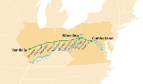
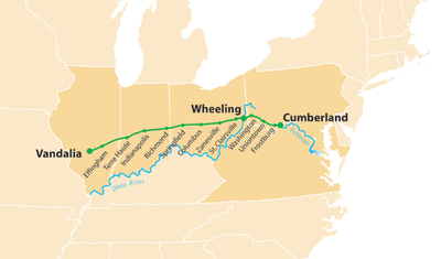
. Construction began heading west in 1811 at Cumberland, Maryland
Cumberland, Maryland
Cumberland is a city in the far western, Appalachian portion of Maryland, United States. It is the county seat of Allegany County, and the primary city of the Cumberland, MD-WV Metropolitan Statistical Area. At the 2010 census, the city had a population of 20,859, and the metropolitan area had a...
, on the Potomac River
Potomac River
The Potomac River flows into the Chesapeake Bay, located along the mid-Atlantic coast of the United States. The river is approximately long, with a drainage area of about 14,700 square miles...
. It crossed the Allegheny Mountains
Allegheny Mountains
The Allegheny Mountain Range , also spelled Alleghany, Allegany and, informally, the Alleghenies, is part of the vast Appalachian Mountain Range of the eastern United States and Canada...
and southwestern Pennsylvania
Pennsylvania
The Commonwealth of Pennsylvania is a U.S. state that is located in the Northeastern and Mid-Atlantic regions of the United States. The state borders Delaware and Maryland to the south, West Virginia to the southwest, Ohio to the west, New York and Ontario, Canada, to the north, and New Jersey to...
, reaching Wheeling, Virginia (now West Virginia
West Virginia
West Virginia is a state in the Appalachian and Southeastern regions of the United States, bordered by Virginia to the southeast, Kentucky to the southwest, Ohio to the northwest, Pennsylvania to the northeast and Maryland to the east...
), on the Ohio River
Ohio River
The Ohio River is the largest tributary, by volume, of the Mississippi River. At the confluence, the Ohio is even bigger than the Mississippi and, thus, is hydrologically the main stream of the whole river system, including the Allegheny River further upstream...
in 1818. Plans were made to continue through St. Louis
St. Louis, Missouri
St. Louis is an independent city on the eastern border of Missouri, United States. With a population of 319,294, it was the 58th-largest U.S. city at the 2010 U.S. Census. The Greater St...
, at confluence of the Mississippi
Mississippi River
The Mississippi River is the largest river system in North America. Flowing entirely in the United States, this river rises in western Minnesota and meanders slowly southwards for to the Mississippi River Delta at the Gulf of Mexico. With its many tributaries, the Mississippi's watershed drains...
and Missouri River
Missouri River
The Missouri River flows through the central United States, and is a tributary of the Mississippi River. It is the longest river in North America and drains the third largest area, though only the thirteenth largest by discharge. The Missouri's watershed encompasses most of the American Great...
s, and to Jefferson City
Jefferson City, Missouri
Jefferson City is the capital of the U.S. state of Missouri and the county seat of Cole County. Located in Callaway and Cole counties, it is the principal city of the Jefferson City metropolitan area, which encompasses the entirety of both counties. As of the 2010 census, the population was 43,079...
upstream on the Missouri. Following the panic of 1837
Panic of 1837
The Panic of 1837 was a financial crisis or market correction in the United States built on a speculative fever. The end of the Second Bank of the United States had produced a period of runaway inflation, but on May 10, 1837 in New York City, every bank began to accept payment only in specie ,...
however, funding ran dry and construction was stopped at Vandalia, Illinois
Vandalia, Illinois
Vandalia is a city in Fayette County, Illinois, United States, northeast of St. Louis, on the Kaskaskia River. From 1819 to 1839 it served as the state capital of Illinois. Vandalia was the western terminus of the National Road. Today it is the county seat of Fayette County and the home of the...
, after crossing the states of Ohio
Ohio
Ohio is a Midwestern state in the United States. The 34th largest state by area in the U.S.,it is the 7th‑most populous with over 11.5 million residents, containing several major American cities and seven metropolitan areas with populations of 500,000 or more.The state's capital is Columbus...
and Indiana
Indiana
Indiana is a US state, admitted to the United States as the 19th on December 11, 1816. It is located in the Midwestern United States and Great Lakes Region. With 6,483,802 residents, the state is ranked 15th in population and 16th in population density. Indiana is ranked 38th in land area and is...
.
Beyond the National Road's eastern terminus at Cumberland and toward the Atlantic coast, a series of private turnpikes
Toll road
A toll road is a privately or publicly built road for which a driver pays a toll for use. Structures for which tolls are charged include toll bridges and toll tunnels. Non-toll roads are financed using other sources of revenue, most typically fuel tax or general tax funds...
were completed in 1824, connecting the National Road with Baltimore, Maryland and its port on Chesapeake Bay
Chesapeake Bay
The Chesapeake Bay is the largest estuary in the United States. It lies off the Atlantic Ocean, surrounded by Maryland and Virginia. The Chesapeake Bay's drainage basin covers in the District of Columbia and parts of six states: New York, Pennsylvania, Delaware, Maryland, Virginia, and West...
; these feeder routes formed what is referred to as an eastern extension of the National Road. In 1835, the road east of Wheeling was turned over to the states for operation as a turnpike. It came to be known as the National Pike, a name also applied to the Baltimore extension. The road's route between Baltimore and Cumberland continues to use the name National Pike or Baltimore National Pike today, with various portions now signed as U.S. Route 40
U.S. Route 40
U.S. Route 40 is an east–west United States highway. As with most routes whose numbers end in a zero, U.S. 40 once traversed the entire United States. It is one of the original 1920s U.S. Highways, and its first termini were San Francisco, California, and Atlantic City, New Jersey...
, Alternate U.S. 40
U.S. Route 40 Alternate
U.S. Route 40 Alternate may refer to:*U.S. Route 40 Alternate *U.S. Route 40 Alternate *California State Highway 70, formerly U.S. Route 40 Alternate...
, or Maryland 144
Maryland Route 144
Maryland Route 144 is a collection of state highways in the U.S. state of Maryland. These highways are sections of old alignment of U.S. Route 40 between Cumberland and Baltimore...
. A spur between Frederick, Maryland
Frederick, Maryland
Frederick is a city in north-central Maryland. It is the county seat of Frederick County, the largest county by area in the state of Maryland. Frederick is an outlying community of the Washington-Arlington-Alexandria, DC-VA-MD-WV Metropolitan Statistical Area, which is part of a greater...
, and Georgetown in Washington, D.C.
Washington, D.C.
Washington, D.C., formally the District of Columbia and commonly referred to as Washington, "the District", or simply D.C., is the capital of the United States. On July 16, 1790, the United States Congress approved the creation of a permanent national capital as permitted by the U.S. Constitution....
, now Maryland Route 355
Maryland Route 355
Maryland Route 355 is a north–south road in western central Maryland in the United States. The southern terminus of the route is at the Washington, D.C. border in Friendship Heights, Montgomery County, where it continues south as Wisconsin Avenue into Washington. The northern terminus is...
, bears various local names but is sometimes referred to as the Washington National Pike; it is now paralleled by Interstate 270
Interstate 270 (Maryland)
Interstate 270 is a auxiliary Interstate Highway in the U.S. state of Maryland that travels between Interstate 495 just north of Bethesda, Montgomery County and Interstate 70 in the city of Frederick in Frederick County. It consists of the mainline as well as a spur that provides access to and...
between the Capital Beltway (I-495)
Interstate 495 (Capital Beltway)
Interstate 495 is a Interstate Highway that surrounds the United States' capital of Washington, D.C., and its inner suburbs in adjacent Maryland and Virginia. I-495 is widely known as the Capital Beltway or simply the Beltway, especially when the context of Washington, D.C., is clear...
and Frederick.
The approximately 620 miles (997.8 km) long National Road provided a connection between the Potomac
Potomac River
The Potomac River flows into the Chesapeake Bay, located along the mid-Atlantic coast of the United States. The river is approximately long, with a drainage area of about 14,700 square miles...
and Ohio River
Ohio River
The Ohio River is the largest tributary, by volume, of the Mississippi River. At the confluence, the Ohio is even bigger than the Mississippi and, thus, is hydrologically the main stream of the whole river system, including the Allegheny River further upstream...
s and a gateway to the West
Western United States
.The Western United States, commonly referred to as the American West or simply "the West," traditionally refers to the region comprising the westernmost states of the United States. Because the U.S. expanded westward after its founding, the meaning of the West has evolved over time...
for thousands of settlers. It was the first road in the U.S. to use the new macadam
Macadam
Macadam is a type of road construction pioneered by the Scotsman John Loudon McAdam in around 1820. The method simplified what had been considered state-of-the-art at that point...
road surfacing.
Today, much of the alignment is followed by U.S. 40
U.S. Route 40
U.S. Route 40 is an east–west United States highway. As with most routes whose numbers end in a zero, U.S. 40 once traversed the entire United States. It is one of the original 1920s U.S. Highways, and its first termini were San Francisco, California, and Atlantic City, New Jersey...
, with various portions bearing the Alternate U.S. 40
U.S. Route 40 Alternate
U.S. Route 40 Alternate may refer to:*U.S. Route 40 Alternate *U.S. Route 40 Alternate *California State Highway 70, formerly U.S. Route 40 Alternate...
designation, or various state-road numbers. The full road, including extensions east to Baltimore and west to St. Louis, was designated "The Historic National Road, an All-American Road" in 2002.
History
Braddock Road
The Braddock RoadBraddock Road (Route 40)
The Braddock Road was a military road built in 1755 in what was then British America and is now the United States. It was the first improved road to cross the barrier of the successive ridgelines of the Appalachian Mountains...
had been opened by the Ohio Company
Ohio Company
The Ohio Company, formally known as the Ohio Company of Virginia, was a land speculation company organized for the settlement by Virginians of the Ohio Country and to trade with the Indians there...
in 1751 between Cumberland, Maryland
Cumberland, Maryland
Cumberland is a city in the far western, Appalachian portion of Maryland, United States. It is the county seat of Allegany County, and the primary city of the Cumberland, MD-WV Metropolitan Statistical Area. At the 2010 census, the city had a population of 20,859, and the metropolitan area had a...
, the limit of navigation on the Potomac River
Potomac River
The Potomac River flows into the Chesapeake Bay, located along the mid-Atlantic coast of the United States. The river is approximately long, with a drainage area of about 14,700 square miles...
, and the French Fort Duquesne
Fort Duquesne
Fort Duquesne was a fort established by the French in 1754, at the junction of the Allegheny and Monongahela rivers in what is now downtown Pittsburgh in the state of Pennsylvania....
at the forks of the Ohio River
Ohio River
The Ohio River is the largest tributary, by volume, of the Mississippi River. At the confluence, the Ohio is even bigger than the Mississippi and, thus, is hydrologically the main stream of the whole river system, including the Allegheny River further upstream...
, a site that would later become Pittsburgh, Pennsylvania
Pittsburgh, Pennsylvania
Pittsburgh is the second-largest city in the US Commonwealth of Pennsylvania and the county seat of Allegheny County. Regionally, it anchors the largest urban area of Appalachia and the Ohio River Valley, and nationally, it is the 22nd-largest urban area in the United States...
. It received its name during the French and Indian War
French and Indian War
The French and Indian War is the common American name for the war between Great Britain and France in North America from 1754 to 1763. In 1756, the war erupted into the world-wide conflict known as the Seven Years' War and thus came to be regarded as the North American theater of that war...
when it was used by General Edward Braddock
Edward Braddock
General Edward Braddock was a British soldier and commander-in-chief for the 13 colonies during the actions at the start of the French and Indian War...
and George Washington
George Washington
George Washington was the dominant military and political leader of the new United States of America from 1775 to 1799. He led the American victory over Great Britain in the American Revolutionary War as commander-in-chief of the Continental Army from 1775 to 1783, and presided over the writing of...
in the Braddock expedition
Braddock expedition
The Braddock expedition, also called Braddock's campaign or, more commonly, Braddock's Defeat, was a failed British military expedition which attempted to capture the French Fort Duquesne in the summer of 1755 during the French and Indian War. It was defeated at the Battle of the Monongahela on...
, an attempt to assault Fort Duquesne.
Cumberland Road
Construction of the Cumberland Road (which later became part of the National Road) was authorized on March 29, 1806, by President Thomas JeffersonThomas Jefferson
Thomas Jefferson was the principal author of the United States Declaration of Independence and the Statute of Virginia for Religious Freedom , the third President of the United States and founder of the University of Virginia...
. The Cumberland Road would replace the Braddock Road for travel between the Potomac and Ohio Rivers, following roughly the same alignment until just east of Uniontown, Pennsylvania
Uniontown, Pennsylvania
Uniontown is a city in Fayette County, Pennsylvania, southeast of Pittsburgh and part of the Pittsburgh Metro Area. Population in 1900, 7,344; in 1910, 13,344; in 1920, 15,692; and in 1940, 21,819. The population was 10,372 at the 2010 census...
. From there, where the Braddock Road turned north to Pittsburgh, the Cumberland Road would continue west to Wheeling, West Virginia
Wheeling, West Virginia
Wheeling is a city in Ohio and Marshall counties in the U.S. state of West Virginia; it is the county seat of Ohio County. Wheeling is the principal city of the Wheeling Metropolitan Statistical Area...
(then part of Virginia
Virginia
The Commonwealth of Virginia , is a U.S. state on the Atlantic Coast of the Southern United States. Virginia is nicknamed the "Old Dominion" and sometimes the "Mother of Presidents" after the eight U.S. presidents born there...
), also on the Ohio River.
The contract for the construction of the first section was awarded to Henry McKinley on May 8, 1811, and construction began later that year, with the road reaching Wheeling on August 1, 1818.
Westward extension
St. Louis, Missouri
St. Louis is an independent city on the eastern border of Missouri, United States. With a population of 319,294, it was the 58th-largest U.S. city at the 2010 U.S. Census. The Greater St...
, on the Mississippi River
Mississippi River
The Mississippi River is the largest river system in North America. Flowing entirely in the United States, this river rises in western Minnesota and meanders slowly southwards for to the Mississippi River Delta at the Gulf of Mexico. With its many tributaries, the Mississippi's watershed drains...
, and on March 3, 1825, across the Mississippi to Jefferson City, Missouri
Jefferson City, Missouri
Jefferson City is the capital of the U.S. state of Missouri and the county seat of Cole County. Located in Callaway and Cole counties, it is the principal city of the Jefferson City metropolitan area, which encompasses the entirety of both counties. As of the 2010 census, the population was 43,079...
. Work on the extension between Wheeling and Zanesville, Ohio
Zanesville, Ohio
Zanesville is a city in and the county seat of Muskingum County, Ohio, United States. The population was 25,586 at the 2000 census.Zanesville was named after Ebenezer Zane, who had constructed Zane's Trace, a pioneer road through present-day Ohio...
, utilized the pre-existing Zane's Trace
Zane's Trace
Zane's Trace is a frontier road constructed under the direction of Col. Ebenezer Zane through the Northwest Territory of the United States, in what is now the state of Ohio. Many portions were based on traditional Native American trails...
, and was completed in 1833 to Columbus, Ohio
Columbus, Ohio
Columbus is the capital of and the largest city in the U.S. state of Ohio. The broader metropolitan area encompasses several counties and is the third largest in Ohio behind those of Cleveland and Cincinnati. Columbus is the third largest city in the American Midwest, and the fifteenth largest city...
, and in 1838 to Springfield, Ohio
Springfield, Ohio
Springfield is a city in the U.S. state of Ohio and the county seat of Clark County. The municipality is located in southwestern Ohio and is situated on the Mad River, Buck Creek and Beaver Creek, approximately west of Columbus and northeast of Dayton. Springfield is home to Wittenberg...
.
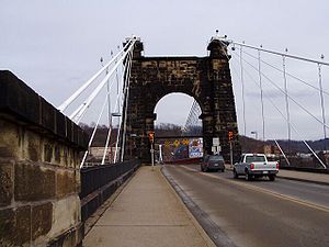
At Wheeling, the National Road crossed the Ohio River
Ohio River
The Ohio River is the largest tributary, by volume, of the Mississippi River. At the confluence, the Ohio is even bigger than the Mississippi and, thus, is hydrologically the main stream of the whole river system, including the Allegheny River further upstream...
on the Wheeling Suspension Bridge
Wheeling Suspension Bridge
The Wheeling Suspension Bridge is a suspension bridge spanning the main channel of the Ohio River at Wheeling, West Virginia. It was the largest suspension bridge in the world from 1849 until the Queenston-Lewiston Bridge was opened in 1851. It was designed by Charles Ellet Jr., who also worked...
, designed by Charles Ellet Jr. and completed in 1849, then the world's longest bridge span at 1010 feet (307.8 m) from tower to tower.
Transfer to states
On April 1, 1835, the section east of Wheeling was transferred to the three states, which made it a turnpike. The last Congressional appropriationAppropriation (law)
In law and government, appropriation is the act of setting apart something for its application to a particular usage, to the exclusion of all other uses....
was made May 25, 1838, and in 1840 Congress voted against completing the unfinished portion of the road, with the deciding vote cast by Henry Clay
Henry Clay
Henry Clay, Sr. , was a lawyer, politician and skilled orator who represented Kentucky separately in both the Senate and in the House of Representatives...
. By that time, railroads were proving a better method of transportation, and the Baltimore and Ohio Railroad
Baltimore and Ohio Railroad
The Baltimore and Ohio Railroad was one of the oldest railroads in the United States and the first common carrier railroad. It came into being mostly because the city of Baltimore wanted to compete with the newly constructed Erie Canal and another canal being proposed by Pennsylvania, which...
was being built west from Baltimore to Cumberland, mostly along the Potomac River
Potomac River
The Potomac River flows into the Chesapeake Bay, located along the mid-Atlantic coast of the United States. The river is approximately long, with a drainage area of about 14,700 square miles...
, then by a more direct route than the National Road across the Allegheny Plateau
Allegheny Plateau
The Allegheny Plateau is a large dissected plateau area in western and central New York, northern and western Pennsylvania, northern and western West Virginia, and eastern Ohio...
of West Virginia (then Virginia) to Wheeling. Construction of the National Road stopped in 1839, and much of the road through Indiana and Illinois remained unfinished, and was later transferred to the states.
Subsequent events
In 1912, the National Road was chosen to become part of the National Old Trails Road, which would extend further east to New York CityNew York City
New York is the most populous city in the United States and the center of the New York Metropolitan Area, one of the most populous metropolitan areas in the world. New York exerts a significant impact upon global commerce, finance, media, art, fashion, research, technology, education, and...
and west to San Francisco, California
San Francisco, California
San Francisco , officially the City and County of San Francisco, is the financial, cultural, and transportation center of the San Francisco Bay Area, a region of 7.15 million people which includes San Jose and Oakland...
. Five Madonna of the Trail
Madonna of the Trail
Madonna of the Trail is a series of 12 monuments dedicated to the spirit of pioneer women in the United States. The monuments were commissioned by the National Society of Daughters of the American Revolution...
monuments were erected along the old National Road.
In 1927, the National Road was designated as the eastern part of U.S. Highway 40, which still generally follows the National Road's alighment with occasional bypasses, realignments, and newer bridges. The mostly parallel Interstate 70
Interstate 70
Interstate 70 is an Interstate Highway in the United States that runs from Interstate 15 near Cove Fort, Utah, to a Park and Ride near Baltimore, Maryland. It was the first Interstate Highway project in the United States. I-70 approximately traces the path of U.S. Route 40 east of the Rocky...
now provides a faster route for through travel without the many sharp curves, steep grades, and narrow bridges of U.S. 40 and other segments of the National Road. However, between Hancock
Hancock, Maryland
Hancock is a town in Washington County, Maryland, United States. The population was 1,725 at the 2000 census. The Western Maryland community is notable for being located at the narrowest part of the state...
in western Maryland
Maryland
Maryland is a U.S. state located in the Mid Atlantic region of the United States, bordering Virginia, West Virginia, and the District of Columbia to its south and west; Pennsylvania to its north; and Delaware to its east...
and Washington, Pennsylvania
Washington, Pennsylvania
Washington is a city in and the county seat of Washington County, Pennsylvania, United States, within the Pittsburgh Metro Area in the southwestern part of the state...
, I-70 takes a more northerly path to follow the Pennsylvania Turnpike
Pennsylvania Turnpike
The Pennsylvania Turnpike is a toll highway system operated by the Pennsylvania Turnpike Commission in the Commonwealth of Pennsylvania, United States. The three sections of the turnpike system total . The main section extends from Ohio to New Jersey and is long...
(also designated as I-76
Interstate 76
Interstate 76 may refer to:* Interstate 76 , an Interstate Highway in the United States, running through New Jersey, Pennsylvania, and Ohio* Interstate 76 , an Interstate Highway in the United States, running through Nebraska and Colorado...
) across the mountains between Breezewood
Breezewood, Pennsylvania
Breezewood is an unincorporated town in Bedford County in south-central Pennsylvania.Along a traditional pathway for Native Americans, European settlers, and British troops during colonial times, in the early 20th century, the small valley that became known as Breezewood was a popular stopping...
and New Stanton
New Stanton, Pennsylvania
New Stanton is a borough in Westmoreland County, Pennsylvania, United States. The population was 1,906 at the 2000 census. New Stanton is often used as a control city in western parts of Pennsylvania, as I-70 joins the Pennsylvania Turnpike eastbound towards Breezewood, Pennsylvania in New...
, where I-70 turns west to rejoin the National Road's route (and U.S 40) near Washington, Pennsylvania.
The more recently constructed Interstate 68
Interstate 68
Interstate 68 is a Interstate highway in the U.S. states of West Virginia and Maryland, connecting in Morgantown to in Hancock. is also Corridor E of the Appalachian Development Highway System. From 1965 until the freeway's construction was completed in 1991, it was designated as...
parallels the old road from Hancock through Cumberland west to Keyser's Ridge, Maryland, where the National Road and U.S. 40 turn northwest into Pennsylvania, but I-68 continues directly west to meet Interstate 79
Interstate 79
Interstate 79 is an Interstate Highway in the eastern United States, designated from Interstate 77 in Charleston, West Virginia to Pennsylvania Route 5 and Pennsylvania Route 290 in Erie, Pennsylvania...
near Morgantown, West Virginia
Morgantown, West Virginia
Morgantown is a city in Monongalia County, West Virginia. It is the county seat of Monongalia County. Placed along the banks of the Monongahela River, Morgantown is the largest city in North-Central West Virginia, and the base of the Morgantown metropolitan area...
. The portion of I-68 in Maryland is designated as the National Freeway.
Historical structures
Arch bridge
An arch bridge is a bridge with abutments at each end shaped as a curved arch. Arch bridges work by transferring the weight of the bridge and its loads partially into a horizontal thrust restrained by the abutments at either side...
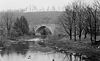
s also remain on former alignments. Notable among these is the Casselman River Bridge
Casselman Bridge, National Road
Casselman Bridge, also known as Casselmans Bridge, was completed in 1811 and opened for traffic in 1813 to carry the National Road across the Casselman River near Grantsville in western Maryland. The bridge was built to aid in the westward movement through the wilderness west of Cumberland...
near Grantsville, Maryland
Grantsville, Maryland
Grantsville is a town in Garrett County, Maryland, United States. The population was 619 at the 2000 census.-History:Grantsville, 1/2 mile west of the Casselman River, began as a small Amish and Mennonite settlement, called Tomlinson's or Little Crossing, along Braddock rd., which wound westward...
; built in 1813-1814, it was the longest single-span stone arch bridge in the world at the time.
The Wheeling Suspension Bridge
Wheeling Suspension Bridge
The Wheeling Suspension Bridge is a suspension bridge spanning the main channel of the Ohio River at Wheeling, West Virginia. It was the largest suspension bridge in the world from 1849 until the Queenston-Lewiston Bridge was opened in 1851. It was designed by Charles Ellet Jr., who also worked...
across the Ohio River, opened in 1849, is the oldest vehicular suspension bridge in the United States still in use. A parallel bridge constructed for U.S. 40 now handles most local traffic, and a larger, newer bridge carries I-70 and the realigned U.S. 40 across the river nearby. The original bridge is listed as both a National Historic Landmark
National Historic Landmark
A National Historic Landmark is a building, site, structure, object, or district, that is officially recognized by the United States government for its historical significance...
and Historic Civil Engineering Landmark.
One of the road's original toll house
Toll house
A tollhouse or toll house is a building with accommodation for a toll collector, beside a tollgate on a toll road or canal. Many tollhouses were built by turnpike trusts in England, Wales and Scotland during the 18th and early 19th centuries...
s is preserved in La Vale, Maryland
La Vale, Maryland
La Vale is a census-designated place in Allegany County, Maryland, United States. It is part of the 'Cumberland, MD-WV Metropolitan Statistical Area'...
, and two others are located in Addison, Pennsylvania
Addison, Pennsylvania
Addison is a borough in Somerset County, Pennsylvania, United States. It is part of the Johnstown, Pennsylvania Metropolitan Statistical Area. The population was 214 at the 2000 census.-Geography:...
, and near Uniontown, Pennsylvania
Uniontown, Pennsylvania
Uniontown is a city in Fayette County, Pennsylvania, southeast of Pittsburgh and part of the Pittsburgh Metro Area. Population in 1900, 7,344; in 1910, 13,344; in 1920, 15,692; and in 1940, 21,819. The population was 10,372 at the 2010 census...
.
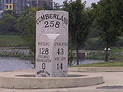
Many mile markers can still be found along the National Road, some well-maintained, others deteriorating, and yet others represented by modern replacements.
Various sections of brick
Brick
A brick is a block of ceramic material used in masonry construction, usually laid using various kinds of mortar. It has been regarded as one of the longest lasting and strongest building materials used throughout history.-History:...
pavement, built in the early twentieth century, are still in use on little-traveled alignments, particularly in eastern Ohio.
Route description

Kaskaskia River
The Kaskaskia River is a tributary of the Mississippi River, approximately long, in central and southern Illinois in the United States. The second largest river system within Illinois, it drains a rural area of farms, as well as rolling hills along river bottoms of hardwood forests in its lower...
in Vandalia, Illinois
Vandalia, Illinois
Vandalia is a city in Fayette County, Illinois, United States, northeast of St. Louis, on the Kaskaskia River. From 1819 to 1839 it served as the state capital of Illinois. Vandalia was the western terminus of the National Road. Today it is the county seat of Fayette County and the home of the...
, near the intersection of modern U.S. 51 and U.S. 40. The road proceeded east along modern U.S. 40 through south central Illinois. The National Road continued into Indiana along modern U.S. 40, passing by the cities of Terre Haute and Indianapolis. Within Indianapolis, the National Road used the original alignment of U.S. 40 along West Washington and East Washington street
Washington Street (Indianapolis)
Washington Street is the primary east-west street in Indianapolis, Indiana, United States. The street follows the route of the National Road for almost all of its length in the city of Indianapolis. For a time, its entire length was designated as U.S...
s (modern U.S. 40 is now routed along I-465). East of Indianapolis, the road went through the city of Richmond before entering the state of Ohio. In Ohio, the road continued along modern U.S. 40 and passed through the northern suburbs of Dayton, Springfield, and the city of Columbus. West of Zanesville, Ohio
Zanesville, Ohio
Zanesville is a city in and the county seat of Muskingum County, Ohio, United States. The population was 25,586 at the 2000 census.Zanesville was named after Ebenezer Zane, who had constructed Zane's Trace, a pioneer road through present-day Ohio...
, despite U.S. 40's predominantly following the original route, many segments of the original road can still be found. Between Old Washington and Morristown, the original roadbed has been overlaid by I-70. The road then continued east across the Ohio River
Ohio River
The Ohio River is the largest tributary, by volume, of the Mississippi River. At the confluence, the Ohio is even bigger than the Mississippi and, thus, is hydrologically the main stream of the whole river system, including the Allegheny River further upstream...
into Wheeling in West Virginia, the original western end of the National Road when it was first paved. After running 15 miles (24.1 km) in West Virginia, the National Road then entered Pennsylvania. The road cut across southwestern Pennsylvania, heading southeast for about 90 miles (144.8 km) before entering Maryland. East of Keyser's Ridge, the road used modern Alternate U.S. 40 to the city of Cumberland (modern U.S. 40 is now routed along I-68). Cumberland was the original eastern terminus of the road. In the mid-19th century, a turnpike extension to Baltimore – along what is now Maryland Route 144 from Cumberland to Hancock, U.S. 40 from Hancock to Hagerstown, Alternate U.S. 40 from Hagerstown to Frederick, and Maryland Route 144 from Frederick to Baltimore – was approved. The approval process was a hotly debated subject because of the removal of the original macadam construction that made this road famous.
National Register designations
The following structures associated with the National Road are listed on the National Register of Historic PlacesNational Register of Historic Places
The National Register of Historic Places is the United States government's official list of districts, sites, buildings, structures, and objects deemed worthy of preservation...
:
- Several milestones in Maryland on former Maryland Route 144Maryland Route 144Maryland Route 144 is a collection of state highways in the U.S. state of Maryland. These highways are sections of old alignment of U.S. Route 40 between Cumberland and Baltimore...
and Maryland Route 165Maryland Route 165Maryland Route 165 is a state highway in the U.S. state of Maryland. The state highway runs from Baldwin north to the Pennsylvania state line in Cardiff, where the highway continues as Pennsylvania Route 74 . MD 165 passes through western and northern Harford County, where it connects the...
, U.S. 40U.S. Route 40U.S. Route 40 is an east–west United States highway. As with most routes whose numbers end in a zero, U.S. 40 once traversed the entire United States. It is one of the original 1920s U.S. Highways, and its first termini were San Francisco, California, and Atlantic City, New Jersey...
, Alternate U.S. 40, and Scenic U.S. 40 - Inns on the National RoadInns on the National RoadThe Inns on the National Road is a national historic district near Cumberland, Allegany County, Maryland. It originally consisted of 11 Maryland inns on the National Road and located in Allegany and Garrett counties...
in Cumberland, MarylandCumberland, MarylandCumberland is a city in the far western, Appalachian portion of Maryland, United States. It is the county seat of Allegany County, and the primary city of the Cumberland, MD-WV Metropolitan Statistical Area. At the 2010 census, the city had a population of 20,859, and the metropolitan area had a...
, and Grantsville, MarylandGrantsville, MarylandGrantsville is a town in Garrett County, Maryland, United States. The population was 619 at the 2000 census.-History:Grantsville, 1/2 mile west of the Casselman River, began as a small Amish and Mennonite settlement, called Tomlinson's or Little Crossing, along Braddock rd., which wound westward... - Casselman River BridgeCasselman Bridge, National RoadCasselman Bridge, also known as Casselmans Bridge, was completed in 1811 and opened for traffic in 1813 to carry the National Road across the Casselman River near Grantsville in western Maryland. The bridge was built to aid in the westward movement through the wilderness west of Cumberland...
near Grantsville, MarylandGrantsville, MarylandGrantsville is a town in Garrett County, Maryland, United States. The population was 619 at the 2000 census.-History:Grantsville, 1/2 mile west of the Casselman River, began as a small Amish and Mennonite settlement, called Tomlinson's or Little Crossing, along Braddock rd., which wound westward... - Petersburg TollhousePetersburg TollhouseThe Petersburg Tollhouse, now located in the hamlet of Addison, Pennsylvania, United States, was the first tollhouse that travelers encountered while on the National Road heading west into Pennsylvania. The Old Route 40 now sits atop the National Pike at this tollhouse...
in Addison, PennsylvaniaAddison, PennsylvaniaAddison is a borough in Somerset County, Pennsylvania, United States. It is part of the Johnstown, Pennsylvania Metropolitan Statistical Area. The population was 214 at the 2000 census.-Geography:... - Searights Tollhouse, National RoadSearights Tollhouse, National RoadSearights Tollhouse, National Road is a site near Uniontown, Pennsylvania on the National Road.It was declared a National Historic Landmark in 1964.It is located on United States Route 40 west of Uniontown....
, in Uniontown, PennsylvaniaUniontown, PennsylvaniaUniontown is a city in Fayette County, Pennsylvania, southeast of Pittsburgh and part of the Pittsburgh Metro Area. Population in 1900, 7,344; in 1910, 13,344; in 1920, 15,692; and in 1940, 21,819. The population was 10,372 at the 2010 census... - Dunlap's Creek BridgeDunlap's Creek BridgeDunlap's Creek Bridge was the first cast iron, metal arch bridge in the United States. It was designed by Richard Delafield and built by the United States Army Corps of Engineers. Constructed from 1836 to 1839 on the National Road in Brownsville, Pennsylvania, it remains in use today...
, near Brownsville, PennsylvaniaBrownsville, PennsylvaniaBrownsville is a borough in Fayette County, Pennsylvania, United States, officially founded in 1785 located 35 miles south of Pittsburgh along the Monongahela River...
, the first cast ironCast ironCast iron is derived from pig iron, and while it usually refers to gray iron, it also identifies a large group of ferrous alloys which solidify with a eutectic. The color of a fractured surface can be used to identify an alloy. White cast iron is named after its white surface when fractured, due...
arch bridgeArch bridgeAn arch bridge is a bridge with abutments at each end shaped as a curved arch. Arch bridges work by transferring the weight of the bridge and its loads partially into a horizontal thrust restrained by the abutments at either side...
in the United StatesUnited StatesThe United States of America is a federal constitutional republic comprising fifty states and a federal district...
. Completed in 1839, it was designed by Richard DelafieldRichard DelafieldRichard Delafield served as superintendent of the United States Military Academy, was Chief of Engineers, and was a major general in the Union Army during the American Civil War.-Biography:...
and built by the United States Army Corps of EngineersUnited States Army Corps of EngineersThe United States Army Corps of Engineers is a federal agency and a major Army command made up of some 38,000 civilian and military personnel, making it the world's largest public engineering, design and construction management agency...
. Still in use, the bridge is also a National Historic Civil Engineering Landmark. - S Bridge in Washington County, PennsylvaniaWashington County, Pennsylvania-Government and politics:As of November 2008, there are 152,534 registered voters in Washington County .* Democratic: 89,027 * Republican: 49,025 * Other Parties: 14,482...
, near Washington, PennsylvaniaWashington, PennsylvaniaWashington is a city in and the county seat of Washington County, Pennsylvania, United States, within the Pittsburgh Metro Area in the southwestern part of the state... - Mile markers 8, 9, 10, 11, 13, and 14 in West VirginiaWest VirginiaWest Virginia is a state in the Appalachian and Southeastern regions of the United States, bordered by Virginia to the southeast, Kentucky to the southwest, Ohio to the northwest, Pennsylvania to the northeast and Maryland to the east...
- National Road Corridor Historic District in Wheeling, West VirginiaWheeling, West VirginiaWheeling is a city in Ohio and Marshall counties in the U.S. state of West Virginia; it is the county seat of Ohio County. Wheeling is the principal city of the Wheeling Metropolitan Statistical Area...
- Wheeling Suspension BridgeWheeling Suspension BridgeThe Wheeling Suspension Bridge is a suspension bridge spanning the main channel of the Ohio River at Wheeling, West Virginia. It was the largest suspension bridge in the world from 1849 until the Queenston-Lewiston Bridge was opened in 1851. It was designed by Charles Ellet Jr., who also worked...
in Wheeling, West VirginiaWheeling, West VirginiaWheeling is a city in Ohio and Marshall counties in the U.S. state of West Virginia; it is the county seat of Ohio County. Wheeling is the principal city of the Wheeling Metropolitan Statistical Area... - A segment of the road in Cambridge, OhioCambridge, OhioAs of the census of 2000, there were 11,520 people, 4,924 households, and 2,954 families residing in the city. The population density was 2,055.1 people per square mile . There were 5,585 housing units of an average density of 996.3 per square mile...
- The Red Brick TavernNational Register of Historic Places listings in Madison County, OhioThis is a list of the National Register of Historic Places listings in Madison County, Ohio.This is intended to be a complete list of the properties and districts on the National Register of Historic Places in Madison County, Ohio, United States...
in Lafayette, OhioLafayette, OhioLafayette is a village in Allen County, Ohio, United States with a population of 304 as of the 2000 U.S. census. It is included in the Lima, Ohio Metropolitan Statistical Area.-Geography:Lafayette is located at ....
, built in 1837 - Hudleston Farmhouse InnHuddleston FarmhouseThe Huddleston Farmhouse Inn in Mount Auburn, Indiana, is an historic inn that once served travelers along the National Road. It was owned by former-Quaker John Huddleston who, with his wife Susannah, and 11 children, offered lodging, cooking materials, and a place for their horses to rest for the...
in Mount Auburn, IndianaMount Auburn, IndianaMount Auburn is a town in Jackson Township, Wayne County, Indiana, United States. The population was 117 at the 2010 census.-Geography:Mount Auburn is located at .... - James Whitcomb Riley HouseRiley Birthplace and MuseumThe Riley Birthplace and Museum, one of two homes called the James Whitcomb Riley House on the National Register of Historic Places, is located at 250 West Main Street in Greenfield, Indiana, twenty miles east of downtown Indianapolis.-History:...
in Indiana - Old Stone Arch, National Road, near Marshall, IllinoisMarshall, IllinoisMarshall is a city in Clark County, Illinois, United States, locatedabout west of Terre Haute, Indiana. The population was 3,771 at the 2000 census...
Further reading
- Raitz, Karl B., et al., eds. The National Road (Johns Hopkins University Press, 1996) online edition
External links
- The National Old Trails Road Part 1: The Quest for a National Road
- Maryland's Bank Road (Baltimore to Cumberland)
- PRR Chronology
- The Historic National Road, from the America's Byways website of the Federal Highway AdministrationFederal Highway AdministrationThe Federal Highway Administration is a division of the United States Department of Transportation that specializes in highway transportation. The agency's major activities are grouped into two "programs," the Federal-aid Highway Program and the Federal Lands Highway Program...
- The National Old Trails Road Photo Gallery
- States promote America's Main Street, a September 2005 Associated PressAssociated PressThe Associated Press is an American news agency. The AP is a cooperative owned by its contributing newspapers, radio and television stations in the United States, which both contribute stories to the AP and use material written by its staff journalists...
article - Casselman River Bridge, the state of MarylandMarylandMaryland is a U.S. state located in the Mid Atlantic region of the United States, bordering Virginia, West Virginia, and the District of Columbia to its south and west; Pennsylvania to its north; and Delaware to its east...
site for the bridge and its surrounding park - National Register of Historic Places nomination form - Pennsylvania
- National Register of Historic Places nomination form - West Virginia
- National Road Association of Illinois - National Road in IllinoisIllinoisIllinois is the fifth-most populous state of the United States of America, and is often noted for being a microcosm of the entire country. With Chicago in the northeast, small industrial cities and great agricultural productivity in central and northern Illinois, and natural resources like coal,...
- Indiana National Road Association - National Road in IndianaIndianaIndiana is a US state, admitted to the United States as the 19th on December 11, 1816. It is located in the Midwestern United States and Great Lakes Region. With 6,483,802 residents, the state is ranked 15th in population and 16th in population density. Indiana is ranked 38th in land area and is...
- Ohio National Road Association - National Road in OhioOhioOhio is a Midwestern state in the United States. The 34th largest state by area in the U.S.,it is the 7th‑most populous with over 11.5 million residents, containing several major American cities and seven metropolitan areas with populations of 500,000 or more.The state's capital is Columbus...
- National Road Alliance of West Virginia - National Road in West VirginiaWest VirginiaWest Virginia is a state in the Appalachian and Southeastern regions of the United States, bordered by Virginia to the southeast, Kentucky to the southwest, Ohio to the northwest, Pennsylvania to the northeast and Maryland to the east...
- National Road Heritage Corridor - National Road in PennsylvaniaPennsylvaniaThe Commonwealth of Pennsylvania is a U.S. state that is located in the Northeastern and Mid-Atlantic regions of the United States. The state borders Delaware and Maryland to the south, West Virginia to the southwest, Ohio to the west, New York and Ontario, Canada, to the north, and New Jersey to...
- Maryland State Highway Administration - National Road in MarylandMarylandMaryland is a U.S. state located in the Mid Atlantic region of the United States, bordering Virginia, West Virginia, and the District of Columbia to its south and west; Pennsylvania to its north; and Delaware to its east...
- 125 M to B: The National Pike and National Road
- The Cumberland Road Project