
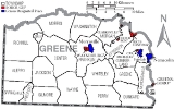
Greene County, Pennsylvania
Encyclopedia
Demographics
As of the censusCensus
A census is the procedure of systematically acquiring and recording information about the members of a given population. It is a regularly occurring and official count of a particular population. The term is used mostly in connection with national population and housing censuses; other common...
of 2000, there were 40,672 people, 15,060 households, and 10,587 families residing in the county. The population density
Population density
Population density is a measurement of population per unit area or unit volume. It is frequently applied to living organisms, and particularly to humans...
was 71 people per square mile (27/km²). There were 16,678 housing units at an average density of 29 per square mile (11/km²). The racial makeup of the county was 99.9% White
Race (United States Census)
Race and ethnicity in the United States Census, as defined by the Federal Office of Management and Budget and the United States Census Bureau, are self-identification data items in which residents choose the race or races with which they most closely identify, and indicate whether or not they are...
, 0.00% Black
Race (United States Census)
Race and ethnicity in the United States Census, as defined by the Federal Office of Management and Budget and the United States Census Bureau, are self-identification data items in which residents choose the race or races with which they most closely identify, and indicate whether or not they are...
or African American
African American
African Americans are citizens or residents of the United States who have at least partial ancestry from any of the native populations of Sub-Saharan Africa and are the direct descendants of enslaved Africans within the boundaries of the present United States...
, 0.05% Native American
Race (United States Census)
Race and ethnicity in the United States Census, as defined by the Federal Office of Management and Budget and the United States Census Bureau, are self-identification data items in which residents choose the race or races with which they most closely identify, and indicate whether or not they are...
, 0.00% Asian
Race (United States Census)
Race and ethnicity in the United States Census, as defined by the Federal Office of Management and Budget and the United States Census Bureau, are self-identification data items in which residents choose the race or races with which they most closely identify, and indicate whether or not they are...
, 0.00% Pacific Islander
Race (United States Census)
Race and ethnicity in the United States Census, as defined by the Federal Office of Management and Budget and the United States Census Bureau, are self-identification data items in which residents choose the race or races with which they most closely identify, and indicate whether or not they are...
, 0.0% from other races
Race (United States Census)
Race and ethnicity in the United States Census, as defined by the Federal Office of Management and Budget and the United States Census Bureau, are self-identification data items in which residents choose the race or races with which they most closely identify, and indicate whether or not they are...
, and 0.00% from two or more races. 0.00% of the population were Hispanic
Race (United States Census)
Race and ethnicity in the United States Census, as defined by the Federal Office of Management and Budget and the United States Census Bureau, are self-identification data items in which residents choose the race or races with which they most closely identify, and indicate whether or not they are...
or Latino
Race (United States Census)
Race and ethnicity in the United States Census, as defined by the Federal Office of Management and Budget and the United States Census Bureau, are self-identification data items in which residents choose the race or races with which they most closely identify, and indicate whether or not they are...
of any race. 18.2% were of German, 13.8% American
United States
The United States of America is a federal constitutional republic comprising fifty states and a federal district...
, 12.9% English
English people
The English are a nation and ethnic group native to England, who speak English. The English identity is of early mediaeval origin, when they were known in Old English as the Anglecynn. England is now a country of the United Kingdom, and the majority of English people in England are British Citizens...
, 12.4% Irish
Irish people
The Irish people are an ethnic group who originate in Ireland, an island in northwestern Europe. Ireland has been populated for around 9,000 years , with the Irish people's earliest ancestors recorded having legends of being descended from groups such as the Nemedians, Fomorians, Fir Bolg, Tuatha...
, 8.2% Italian
Italian people
The Italian people are an ethnic group that share a common Italian culture, ancestry and speak the Italian language as a mother tongue. Within Italy, Italians are defined by citizenship, regardless of ancestry or country of residence , and are distinguished from people...
and 6.7% Polish ancestry according to Census 2000.
There were 15,060 households out of which 30.60% had children under the age of 18 living with them, 55.40% were married couples
Marriage
Marriage is a social union or legal contract between people that creates kinship. It is an institution in which interpersonal relationships, usually intimate and sexual, are acknowledged in a variety of ways, depending on the culture or subculture in which it is found...
living together, 10.90% had a female householder with no husband present, and 29.70% were non-families. 25.70% of all households were made up of individuals and 12.70% had someone living alone who was 65 years of age or older. The average household size was 2.48 and the average family size was 2.97.
In the county, the population was spread out with 22.10% under the age of 18, 9.70% from 18 to 24, 29.00% from 25 to 44, 24.00% from 45 to 64, and 15.20% who were 65 years of age or older. The median age was 38 years. For every 100 females there were 106.20 males. For every 100 females age 18 and over, there were 106.50 males.
Municipalities
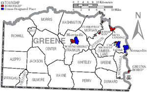
Boroughs
|
Jefferson, Greene County, Pennsylvania Jefferson is a borough in Greene County, Pennsylvania, United States. The population was 337 at the 2000 census.-Geography:Jefferson is located at .... Rices Landing, Pennsylvania Rices Landing is a borough in Greene County, Pennsylvania, United States. The population was 443 at the 2000 census.-Geography:Rices Landing is located at .... Waynesburg, Pennsylvania Waynesburg is a borough in and the county seat of Greene County, Pennsylvania, United States, southwest of Pittsburgh. The population was 4,184 at the 2000 census.... |
Townships
|
Greene Township, Greene County, Pennsylvania Greene Township is a township in Greene County, Pennsylvania, United States. The population was 445 at the 2000 census.-Geography:According to the United States Census Bureau, the township has a total area of , all of it land.-Demographics:... Jackson Township, Greene County, Pennsylvania Jackson Township is a township in Greene County, Pennsylvania, United States. The population was 516 at the 2000 census.-Geography:According to the United States Census Bureau, the township has a total area of , of which, of it is land and 0.03% is water.... Jefferson Township, Greene County, Pennsylvania Jefferson Township is a township in Greene County, Pennsylvania, United States. The population was 2,528 at the 2000 census.-Geography:According to the United States Census Bureau, the township has a total area of , of which, of it is land and of it is water.-Demographics:As of the census of... Morris Township, Greene County, Pennsylvania Morris Township is a township in Greene County, Pennsylvania, United States. The population was 1,040 at the 2000 census.-Geography:According to the United States Census Bureau, the township has a total area of 35.8 square miles , of which, 35.8 square miles of it is land and... |
Perry Township, Greene County, Pennsylvania Perry Township is a township in Greene County, Pennsylvania, United States. The population was 1,720 at the 2000 census.-History:It is the location of the western most point surveyed as part of the Mason-Dixon Line in 1767. In the early 19th century Perry Twp. was part of the Western frontier and... Springhill Township, Greene County, Pennsylvania Springhill Township is a township in Greene County,Pennsylvania, United States. The population was 476 at the 2000 census.-Geography:According to the United States Census Bureau, the township has a total area of 22.1 square miles , of which, 22.1 square miles of it is land and 0.05%... Washington Township, Greene County, Pennsylvania Washington Township is a township in Greene County, Pennsylvania, United States. The population was 1,106 at the 2000 census.-Geography:According to the United States Census Bureau, the township has a total area of 27.0 square miles , of which, 27.0 square miles of it is land and... Wayne Township, Greene County, Pennsylvania Wayne Township is a township in Greene County, Pennsylvania, United States. The population was 1,223 at the 2000 census.-Geography:According to the United States Census Bureau, the township has a total area of 39.5 square miles , of which, 39.4 square miles of it is land and... |
Census-designated places
Census-designated placeCensus-designated place
A census-designated place is a concentration of population identified by the United States Census Bureau for statistical purposes. CDPs are delineated for each decennial census as the statistical counterparts of incorporated places such as cities, towns and villages...
s are geographical areas designated by the U.S. Census Bureau
United States Census Bureau
The United States Census Bureau is the government agency that is responsible for the United States Census. It also gathers other national demographic and economic data...
for the purposes of compiling demographic data. They are not actual jurisdictions under Pennsylvania law. Other unincorporated communities, such as villages, may be listed here as well.
- FairdaleFairdale, PennsylvaniaFairdale is a community and census-designated place in Greene County, Pennsylvania, United States. The population was 1,955 at the 2000 census.-Geography:Fairdale is located at ....
- MorrisvilleMorrisville, Greene County, PennsylvaniaMorrisville is a census-designated place in Greene County, Pennsylvania, United States. The population was 1,443 at the 2000 census.-Geography:Morrisville is located at ....
- NemacolinNemacolin, PennsylvaniaNemacolin is a census-designated place in Greene County, Pennsylvania, United States founded as a company town around the workings of a YS&T company owned and operated coal mine in 1917 and named for a legendary Amerindian ally Chief Nemacolin, who showed the Virginia settlers how to cross the...
Government and politics
As of November 2010, there are 50,640 registered voters in Greene County http://www.dos.state.pa.us/portal/server.pt/community/voter_registration_statistics/12725.- DemocraticDemocratic Party (United States)The Democratic Party is one of two major contemporary political parties in the United States, along with the Republican Party. The party's socially liberal and progressive platform is largely considered center-left in the U.S. political spectrum. The party has the lengthiest record of continuous...
: 16,592 (65.53%) - RepublicanRepublican Party (United States)The Republican Party is one of the two major contemporary political parties in the United States, along with the Democratic Party. Founded by anti-slavery expansion activists in 1854, it is often called the GOP . The party's platform generally reflects American conservatism in the U.S...
: 6,840 (27.01%) - Other Parties: 1,868 (7.45%)
County commissioners
- Pam Snyder, Chair, Democrat
- Charles Morris, Democrat
- Archie Trader, Republican
Other county officials
- President Judge, Hon. William R. Nalitz
- Associate Judge, Hon. Farley Toothman
- District Attorney, Marjorie J. Fox, Democrat
- Sheriff, Richard Ketchem, Democrat
- Coroner, Greg Rohanna, Democrat
- Clerk of Courts, Sherry Wise, Republican
- Prothonotary, Susan White, Democrat
- Recorder of Deeds and Register of Wills, Tom Headlee, Democrat
- Treasurer, Cory Grandel, Democrat
- Controller, David Balint, Democrat
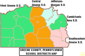
Public School Districts
- Carmichaels Area School DistrictCarmichaels Area School DistrictThe Carmichaels Area School District serves the Borough of Carmichaels and Cumberland Township in Greene County, Pennsylvania. The district operates one elementary school, one junior high school and one senior high school. The district encompasses approximately 39 square miles. According to 2000...
- Central Greene School DistrictCentral Greene School DistrictThe Central Greene School District covers the Borough of Waynesburg and Franklin Township, Perry Township, Washington Township, Wayne Township and Whiteley Township in Greene County, Pennsylvania. It encompasses approximately 168 square miles. According to the 2000 federal census data, it serves a...
- Jefferson-Morgan School DistrictJefferson-Morgan School DistrictJefferson-Morgan School District is located in Greene County, Pennsylvania. It serves the boroughs of Jefferson, Rices Landing, and Clarksville. It also serves Jefferson and Morgan townships. The district encompasses approximately 47 square miles. According to 2000 federal census data, it serves...
- Southeastern Greene School DistrictSoutheastern Greene School DistrictSoutheastern Greene School District is a public school district located in Greene County, Pennsylvania. It serves the borough of Greensboro, Monongahela Township, Dunkard Township, and Greene Township. Upper level students attend the district's Mapletown Jr-Sr High School. The SGSD encompasses...
- West Greene School DistrictWest Greene School DistrictWest Greene School District is a diminutive, rural, public school district located in Greene County, Pennsylvania. An estimated 500 students attend West Greene School District serves a large rural region, including Morris Township, Center Township, Gray Township, Jackson Township, Gilmore Township,...
Highway Infrastructure
 Pennsylvania Route 18Pennsylvania Route 18Pennsylvania Route 18 is a major north–south highway in Western Pennsylvania whose southern terminus is at the West Virginia state line in Greene County, Pennsylvania near the village of Garrison, while the northern terminus is at PA Route 5 in Lake City, Pennsylvania...
- the southernmost segments of one of the few Pennsylvania state routes to touch two state borders, this route begins at the West VirginiaWest VirginiaWest Virginia is a state in the Appalachian and Southeastern regions of the United States, bordered by Virginia to the southeast, Kentucky to the southwest, Ohio to the northwest, Pennsylvania to the northeast and Maryland to the east...
border in Freeport Township; after winding through the rolling hills of southwestern Greene County, it forms a consignment with Route 21 to reach the county seat in WaynesburgWaynesburg, PennsylvaniaWaynesburg is a borough in and the county seat of Greene County, Pennsylvania, United States, southwest of Pittsburgh. The population was 4,184 at the 2000 census....
, before twisting back toward the northwest and into Washington CountyWashington County, Pennsylvania-Government and politics:As of November 2008, there are 152,534 registered voters in Washington County .* Democratic: 89,027 * Republican: 49,025 * Other Parties: 14,482... U.S. Route 19U.S. Route 19U.S. Route 19 is a north–south U.S. Highway. Despite encroaching Interstate Highways, the route has remained a long-haul route, connecting the Gulf of Mexico with Lake Erie....
- although mostly parallel to and bypassed by the interstate system, this highway is a key north-south link in the county; entering from West Virginia and exiting into rural Washington County, this route connects a variety of small communities to Waynesburg, through which it is briefly cosigned with Route 21 Pennsylvania Route 21Pennsylvania Route 21Pennsylvania Route 21 is a long east–west state highway in the US state of Pennsylvania. The western terminus of the route is at the West Virginia state line in Richhill Township, where PA 21 continues into West Virginia as West Virginia Route 891. The eastern terminus is at U.S. Route 40...
- known as the Roy E. Furman Highway, this route is the east-west backbone of the county; the route begins at the border with the West Virginia panhandle, then winds through sparely populated western townships to Waynesburg; after forming the town’s main street, it includes a four-lane segment that features many of the region’s big box stores and commercial strips; the route alternates between two and four-lanes as it travels through hilly eastern villages before crossing the Monongahela RiverMonongahela RiverThe Monongahela River is a river on the Allegheny Plateau in north-central West Virginia and southwestern Pennsylvania in the United States...
into Fayette CountyFayette County, PennsylvaniaFayette County is a county located in the U.S. state of Pennsylvania. As of the2010 census, the population was 136,606. The county is part of the Pittsburgh Metropolitan Statistical Area.... Interstate 79Interstate 79Interstate 79 is an Interstate Highway in the eastern United States, designated from Interstate 77 in Charleston, West Virginia to Pennsylvania Route 5 and Pennsylvania Route 290 in Erie, Pennsylvania...
- as part of its journey between Morgantown, West VirginiaMorgantown, West VirginiaMorgantown is a city in Monongalia County, West Virginia. It is the county seat of Monongalia County. Placed along the banks of the Monongahela River, Morgantown is the largest city in North-Central West Virginia, and the base of the Morgantown metropolitan area...
and suburban Pittsburgh, this interstate highway breezes through Greene County, providing access to Waynesburg and several small communities Pennsylvania Route 88Pennsylvania Route 88Pennsylvania Route 88 is a long north–south state highway located in southwestern Pennsylvania. The southern terminus of the route is at U.S. Route 119 in Point Marion less than from the Pennsylvania-West Virginia border. The northern terminus is at Pennsylvania Route 51 in Pittsburgh...
- part of a long, winding route that travels slowly through suburban Pittsburgh and the Monongahela Valley, this highway runs through small boroughs such as CarmichealsCarmichaels, PennsylvaniaCarmichaels is a borough in Greene County, Pennsylvania, United States. The population was 556 at the 2000 census.-Geography:Carmichaels is located at ....
and Rices LandingRices Landing, PennsylvaniaRices Landing is a borough in Greene County, Pennsylvania, United States. The population was 443 at the 2000 census.-Geography:Rices Landing is located at ....
during its stretch through the county, before exiting on a bridge over the Monongahela to reach its terminus in the small Fayette County town of Point MarionPoint Marion, PennsylvaniaPoint Marion is a borough in Fayette County, Pennsylvania, United States. The population was 1,333 at the 2000 census. It is served by the Albert Gallatin Area School District.Point Marion is located at the confluence of the Monongahela and Cheat Rivers... Pennsylvania Route 188Pennsylvania Route 188Pennsylvania Route 188 is a long east-west state highway in the U.S. state of Pennsylvania. The western terminus of the route is at PA 21 in Morrisville...
- this short rural access route connects Franklin TownshipFranklin Township, Greene County, PennsylvaniaFranklin Township is a township in Greene County, Pennsylvania, United States. The population was 7,694 at the 2000 census.-Geography:According to the United States Census Bureau, the township has a total area of , of which, of it is land and of it is water.-Demographics:As of the census of...
, which holds Waynesburg’s business district, with Morgan Township and Jefferson TownshipJefferson Township, Greene County, PennsylvaniaJefferson Township is a township in Greene County, Pennsylvania, United States. The population was 2,528 at the 2000 census.-Geography:According to the United States Census Bureau, the township has a total area of , of which, of it is land and of it is water.-Demographics:As of the census of...
, before ending at its parent highway, Route 88 Pennsylvania Route 218Pennsylvania Route 218Pennsylvania Route 218 is an long state highway located in Greene county in Pennsylvania. The southern terminus is at the West Virginia state line at Blacksville, WV. The northern terminus is at US 19/PA 21 in Waynesburg.-Route description:...
- this short rural access road connects Waynesburg with a West Virginia highway of the same number, after traveling through a sparely populated area Pennsylvania Route 221Pennsylvania Route 221Pennsylvania Route 221 is an long state highway located in Greene and Washington counties in Pennsylvania. The southern terminus is at PA 188 near Jefferson. The northern terminus is at PA 231 in Acheson.-Greene County:...
- this winding highway traverses northern townships in the county, entering from rural areas of Washington County and ending in Morgan Township at Route 188 Pennsylvania Route 231Pennsylvania Route 231Pennsylvania Route 231 is an long state highway located in Washington county in Pennsylvania. The southern terminus is at PA 18 near Old Concord. The northern terminus is at PA 50 in Avella.-Route description:...
- the final miles of this highway straddle the Washington-Greene County line, as the highway briefly enters Morris TownshipMorris Township, Greene County, PennsylvaniaMorris Township is a township in Greene County, Pennsylvania, United States. The population was 1,040 at the 2000 census.-Geography:According to the United States Census Bureau, the township has a total area of 35.8 square miles , of which, 35.8 square miles of it is land and...
in its waning segments
See also
- List of municipal authorities in Greene County, Pennsylvania
- National Register of Historic Places listings in Greene County, PennsylvaniaNational Register of Historic Places listings in Greene County, PennsylvaniaThis is a list of the National Register of Historic Places listings in Greene County, Pennsylvania.This is intended to be a complete list of the properties and districts on National Register of Historic Places in Greene County, Pennsylvania, United States...