
Grantsville, Maryland
Encyclopedia
Grantsville is a town in Garrett County
, Maryland
, United States. The population was 619 at the 2000 census.
, began as a small Amish
and Mennonite
settlement, called Tomlinson's or Little Crossing, along Braddock rd., which wound westward from Cumberland
over Negro Mountain
. Later a new village flourished as a stop along the nearby National Road
, Route 40. From 1818, the national road carried hundreds of thousands of pioneers and settlers in stagecoaches and covered wagons. In the 1800s, an area just outside Grantsville (once known as Little Crossing but now marked by the Little Crossing Antique Store & Gift Shoppe and an ice cream parlor, The Dip) was a major stop on the old national pike. There is a "dip" in the road that travelers will not miss when they pass through Little Crossing on Route 40.
Signs mark the location of the post office and the blacksmith shop that stayed open all night to fix broken horseshoes. An 1879 article in Harper's Monthly described the wagons as "so numerous that the leaders of one team had their noses in the trough at the end of the next wagon ahead."
The Casselman Inn
sits in the center of town, where it has provided food and lodging to travelers since 1824. A sign outside displays a replica 1842 stagecoach advertisement.
Near the Casselman Bridge, a historic stone arch bridge, is Penn Alps Restaurant and The Spruce Forest Artisan Village, which was founded in 1957 by Alta Schrock. Penn Alps Restaurant is housed in the last log hospitality house on the National Pike. It is situated between a 1797 gristmill and the Casselman Bridge, the longest single span of stone in America when built in 1813.
Spruce Forest Artisan Village, a part of the extended Penn Alps campus, has grown from a few cabins to some 12 log and frame structures of early vintage, two of which date to the Revolutionary War Period. Most of these provide studio space for artisans. Artisans work in various media, including: bird carving, stained glass, basket making, hand-loom weaving, and hand-thrown pottery.
until 2005. It is now served by a Bayrunner Shuttle that began in January 2011 that originates from Grantsville and serves Frostburg
, Cumberland
, Allegany College of Maryland
Cumberland Campus, Hancock
, Hagerstown
, Frederick
Transit Center, Frederick Airport
, BWI, BWI Amtrak Station, and Baltimore
Greyhound Station.
According to the United States Census Bureau
, the town has a total area of 0.7 square miles (1.8 km²), all land.
of 2000, there were 619 people, 278 households, and 177 families residing in the town. The population density
was 877.2 people per square mile (336.6/km²). There were 298 housing units at an average density of 422.3 per square mile (162.1/km²). The racial makeup of the town was 98.87% White, 0.48% African American, 0.32% Asian, and 0.32% from two or more races. Hispanic or Latino of any race were 0.48% of the population.
There were 278 households out of which 30.6% had children under the age of 18 living with them, 43.5% were married couples
living together, 14.7% had a female householder with no husband present, and 36.0% were non-families. 33.1% of all households were made up of individuals and 12.2% had someone living alone who was 65 years of age or older. The average household size was 2.22 and the average family size was 2.74.
In the town the population was spread out with 24.4% under the age of 18, 8.2% from 18 to 24, 28.9% from 25 to 44, 24.1% from 45 to 64, and 14.4% who were 65 years of age or older. The median age was 37 years. For every 100 females there were 86.4 males. For every 100 females age 18 and over, there were 85.0 males.
The median income for a household in the town was $27,778, and the median income for a family was $35,000. Males had a median income of $29,167 versus $21,250 for females. The per capita income
for the town was $15,625. About 22.2% of families and 23.8% of the population were below the poverty line, including 38.0% of those under age 18 and 8.8% of those age 65 or over.
In the 1960s the town had a stable population of approximately 400 individuals.
Garrett County, Maryland
Garrett County is the westernmost county of the U.S. state of Maryland. Created from Allegany County, Maryland in 1872 it was the last Maryland county to be formed. It was named for John Work Garrett , railroad executive, industrialist, and financier. Garrett served as president of the Baltimore...
, Maryland
Maryland
Maryland is a U.S. state located in the Mid Atlantic region of the United States, bordering Virginia, West Virginia, and the District of Columbia to its south and west; Pennsylvania to its north; and Delaware to its east...
, United States. The population was 619 at the 2000 census.
History
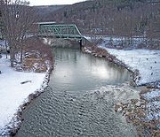
Grantsville, 1/2 mile west of the Casselman RiverCasselman River
The Casselman River is a tributary of the Youghiogheny River in western Maryland and Pennsylvania in the United States.The Casselman River rises atop the plateau of western Maryland and then follows a great arc across the Laurel Highlands of Somerset County, Pennsylvania to the appropriately named...
, began as a small Amish
Amish
The Amish , sometimes referred to as Amish Mennonites, are a group of Christian church fellowships that form a subgroup of the Mennonite churches...
and Mennonite
Mennonite
The Mennonites are a group of Christian Anabaptist denominations named after the Frisian Menno Simons , who, through his writings, articulated and thereby formalized the teachings of earlier Swiss founders...
settlement, called Tomlinson's or Little Crossing, along Braddock rd., which wound westward from Cumberland
Cumberland, Maryland
Cumberland is a city in the far western, Appalachian portion of Maryland, United States. It is the county seat of Allegany County, and the primary city of the Cumberland, MD-WV Metropolitan Statistical Area. At the 2010 census, the city had a population of 20,859, and the metropolitan area had a...
over Negro Mountain
Negro Mountain
Negro Mountain is a long ridge of the Allegheny Mountains extending from Deep Creek Lake in Maryland, north to the Casselman River in Pennsylvania, USA. The summit, Mount Davis, is the highest point in Pennsylvania...
. Later a new village flourished as a stop along the nearby National Road
National Road
The National Road or Cumberland Road was the first major improved highway in the United States to be built by the federal government. Construction began heading west in 1811 at Cumberland, Maryland, on the Potomac River. It crossed the Allegheny Mountains and southwestern Pennsylvania, reaching...
, Route 40. From 1818, the national road carried hundreds of thousands of pioneers and settlers in stagecoaches and covered wagons. In the 1800s, an area just outside Grantsville (once known as Little Crossing but now marked by the Little Crossing Antique Store & Gift Shoppe and an ice cream parlor, The Dip) was a major stop on the old national pike. There is a "dip" in the road that travelers will not miss when they pass through Little Crossing on Route 40.
Signs mark the location of the post office and the blacksmith shop that stayed open all night to fix broken horseshoes. An 1879 article in Harper's Monthly described the wagons as "so numerous that the leaders of one team had their noses in the trough at the end of the next wagon ahead."
The Casselman Inn
Inns on the National Road
The Inns on the National Road is a national historic district near Cumberland, Allegany County, Maryland. It originally consisted of 11 Maryland inns on the National Road and located in Allegany and Garrett counties...
sits in the center of town, where it has provided food and lodging to travelers since 1824. A sign outside displays a replica 1842 stagecoach advertisement.
Near the Casselman Bridge, a historic stone arch bridge, is Penn Alps Restaurant and The Spruce Forest Artisan Village, which was founded in 1957 by Alta Schrock. Penn Alps Restaurant is housed in the last log hospitality house on the National Pike. It is situated between a 1797 gristmill and the Casselman Bridge, the longest single span of stone in America when built in 1813.
Spruce Forest Artisan Village, a part of the extended Penn Alps campus, has grown from a few cabins to some 12 log and frame structures of early vintage, two of which date to the Revolutionary War Period. Most of these provide studio space for artisans. Artisans work in various media, including: bird carving, stained glass, basket making, hand-loom weaving, and hand-thrown pottery.
Transportation
Grantsville was once served by GreyhoundGreyhound
The Greyhound is a breed of sighthound that has been primarily bred for coursing game and racing, and the breed has also recently seen a resurgence in its popularity as a pedigree show dog and family pet. It is a gentle and intelligent breed...
until 2005. It is now served by a Bayrunner Shuttle that began in January 2011 that originates from Grantsville and serves Frostburg
Frostburg, Maryland
Frostburg is a city in Allegany County, Maryland, United States located at the head of the Georges Creek Valley. It is part of the Cumberland, MD-WV Metropolitan Statistical Area. The population was 7,873 at the 2000 census...
, Cumberland
Cumberland, Maryland
Cumberland is a city in the far western, Appalachian portion of Maryland, United States. It is the county seat of Allegany County, and the primary city of the Cumberland, MD-WV Metropolitan Statistical Area. At the 2010 census, the city had a population of 20,859, and the metropolitan area had a...
, Allegany College of Maryland
Allegany College of Maryland
Allegany College of Maryland is a two-year public community college located in Cumberland, Maryland. It was previously known as Allegany Community College .- History :...
Cumberland Campus, Hancock
Hancock, Maryland
Hancock is a town in Washington County, Maryland, United States. The population was 1,725 at the 2000 census. The Western Maryland community is notable for being located at the narrowest part of the state...
, Hagerstown
Hagerstown, Maryland
Hagerstown is a city in northwestern Maryland, United States. It is the county seat of Washington County, and, by many definitions, the largest city in a region known as Western Maryland. The population of Hagerstown city proper at the 2010 census was 39,662, and the population of the...
, Frederick
Frederick, Maryland
Frederick is a city in north-central Maryland. It is the county seat of Frederick County, the largest county by area in the state of Maryland. Frederick is an outlying community of the Washington-Arlington-Alexandria, DC-VA-MD-WV Metropolitan Statistical Area, which is part of a greater...
Transit Center, Frederick Airport
Frederick Municipal Airport (Maryland)
Frederick Municipal Airport is a public airport located in the city of Frederick, in Frederick County, Maryland, United States. This airport is publicly owned by City of Frederick....
, BWI, BWI Amtrak Station, and Baltimore
Baltimore
Baltimore is the largest independent city in the United States and the largest city and cultural center of the US state of Maryland. The city is located in central Maryland along the tidal portion of the Patapsco River, an arm of the Chesapeake Bay. Baltimore is sometimes referred to as Baltimore...
Greyhound Station.
Geography
Grantsville is located at 39°41′49"N 79°9′21"W (39.696969, -79.155918).According to the United States Census Bureau
United States Census Bureau
The United States Census Bureau is the government agency that is responsible for the United States Census. It also gathers other national demographic and economic data...
, the town has a total area of 0.7 square miles (1.8 km²), all land.
Demographics
As of the censusCensus
A census is the procedure of systematically acquiring and recording information about the members of a given population. It is a regularly occurring and official count of a particular population. The term is used mostly in connection with national population and housing censuses; other common...
of 2000, there were 619 people, 278 households, and 177 families residing in the town. The population density
Population density
Population density is a measurement of population per unit area or unit volume. It is frequently applied to living organisms, and particularly to humans...
was 877.2 people per square mile (336.6/km²). There were 298 housing units at an average density of 422.3 per square mile (162.1/km²). The racial makeup of the town was 98.87% White, 0.48% African American, 0.32% Asian, and 0.32% from two or more races. Hispanic or Latino of any race were 0.48% of the population.
There were 278 households out of which 30.6% had children under the age of 18 living with them, 43.5% were married couples
Marriage
Marriage is a social union or legal contract between people that creates kinship. It is an institution in which interpersonal relationships, usually intimate and sexual, are acknowledged in a variety of ways, depending on the culture or subculture in which it is found...
living together, 14.7% had a female householder with no husband present, and 36.0% were non-families. 33.1% of all households were made up of individuals and 12.2% had someone living alone who was 65 years of age or older. The average household size was 2.22 and the average family size was 2.74.
In the town the population was spread out with 24.4% under the age of 18, 8.2% from 18 to 24, 28.9% from 25 to 44, 24.1% from 45 to 64, and 14.4% who were 65 years of age or older. The median age was 37 years. For every 100 females there were 86.4 males. For every 100 females age 18 and over, there were 85.0 males.
The median income for a household in the town was $27,778, and the median income for a family was $35,000. Males had a median income of $29,167 versus $21,250 for females. The per capita income
Per capita income
Per capita income or income per person is a measure of mean income within an economic aggregate, such as a country or city. It is calculated by taking a measure of all sources of income in the aggregate and dividing it by the total population...
for the town was $15,625. About 22.2% of families and 23.8% of the population were below the poverty line, including 38.0% of those under age 18 and 8.8% of those age 65 or over.
In the 1960s the town had a stable population of approximately 400 individuals.