

Earth rainfall climatology
Encyclopedia
Earth rainfall climatology encompasses the rain
fall distribution across different regions of the planet Earth
. In mountainous areas, heavy precipitation is possible where upslope flow is maximized within windward sides of the terrain at elevation. On the leeward side of mountains, desert climates can exist due to the dry air caused by compressional heating. The movement of the monsoon trough
, or intertropical convergence zone
, brings rainy seasons
to savannah
clime
s. The urban heat island
effect leads to increased rainfall, both in amounts and intensity, downwind of cities. Global warming
is also causing changes in the precipitation pattern globally, including wetter conditions across eastern North America
and drier conditions in the tropics. Precipitation is a major component of the water cycle
, and is responsible for depositing most of the fresh water
on the planet
. Approximately 505000 cubic kilometres (121,155.9 cu mi) of water falls as precipitation each year; 398000 cubic kilometres (95,485.3 cu mi) of it over the ocean
s. Given the Earth
's surface area, that means the globally averaged annual precipitation is 990 millimetres (39 in). Climate
classification systems such as the Köppen climate classification
system use average annual rainfall to help differentiate between differing climate regimes.
Most of Australia is semi-arid or desert, making it the world's driest continent
. Australia's rainfall is mainly regulated by the movement of the monsoon trough during the summer rainy season, with lesser amounts falling during the winter and spring in its southernmost sections. The northern half of Africa is primarily desert
or arid
, containing the Sahara
, which central Africa (known as Sub-Saharan Africa
) sees an annual rainy season regulated by the movement of the intertropical convergence zone or monsoon trough. Across Asia, a large annual rainfall minimum, composed primarily of deserts, stretches from the Gobi desert
in Mongolia west-southwest through Pakistan and Iran into the Arabian desert
in Saudi Arabia. In Asia, rainfall is favored across its southern portion from India east and northeast across the Philippines and southern China into Japan due to the monsoon
advecting moisture primarily from the Indian Ocean
into the region. Similar, but weaker, monsoon circulations are present over North America
and Australia
. In Europe
, the wettest regions are in the Alps and downwind of bodies of water. Within North America, the drier areas of the United States are the Desert Southwest, Great Basin, valleys of northeast Arizona, eastern Utah, central Wyoming, and the Willamette Valley. Other dry regions within the continent are far northern Canada and the Sonoran Desert of northwest Mexico. The Pacific Northwest United States, the Rockies of British Columbia, and the coastal ranges of Alaska are the wettest locations in North America. The equatorial region near the Intertropical Convergence Zone
(ITCZ), or monsoon trough
, is the wettest portion of the world's continents. Annually, the rain belt within the tropics marches northward by August, then moves back southward into the Southern Hemisphere
by February and March.
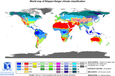
The Köppen classification depends on average monthly values of temperature and precipitation. The most commonly used form of the Köppen classification has five primary types labeled A through E. Specifically, the primary types are A, tropical; B, dry; C, mild mid-latitude; D, cold mid-latitude; and E, polar. The five primary classifications can be further divided into secondary classifications such as rain forest, monsoon
, tropical savanna, humid subtropical, humid continental, oceanic climate
, Mediterranean climate
, steppe
, subarctic climate
, tundra
, polar ice cap
, and desert
.
Rain forests are characterized by high rainfall, with definitions setting minimum normal annual rainfall between 1750 millimetres (68.9 in) and 2000 millimetres (78.7 in). A tropical savanna is a grassland
biome
located in semi-arid
to semi-humid climate regions of subtropical and tropical latitudes, with rainfall between 750 millimetres (29.5 in) and 1270 millimetres (50 in) a year. They are widespread on Africa
, and are also found in India
, the northern parts of South America
, Malaysia, and Australia
. The humid subtropical climate zone where winter rainfall (and sometimes snowfall) is associated with large storm
s that the westerlies
steer from west to east. Most summer rainfall occurs during thunderstorm
s and from occasional tropical cyclone
s. Humid subtropical climates lie on the east side continents, roughly between latitude
s 20° and 40° degrees away from the equator.
An oceanic (or maritime) climate is typically found along the west coasts at the middle latitudes of all the world's continents, bordering cool oceans, as well as southeastern Australia
, and is accompanied by plentiful precipitation year round. The Mediterranean climate regime resembles the climate of the lands in the Mediterranean Basin
, parts of western North America
, parts of Western
and South Australia
, in southwestern South Africa
and in parts of central Chile
. The climate is characterized by hot, dry summers and cool, wet winters. A steppe is a dry grassland
. Subarctic climates are cold with continuous permafrost
and little precipitation.
 Its northern half of the continent is primarily desert
or arid
, containing the Sahara
, while its southern areas contain both savanna
plain
s, and its central portion contains very dense jungle
(rainforest
) regions. The equatorial region near the Intertropical Convergence Zone
is the wettest portion of the continent. Annually, the rain belt across the country marches northward into Sub-Saharan Africa
by August, then moves back southward into south-central Africa by March. Mesoscale convective systems which form in tandem with tropical wave
s that move along the Intertropical Convergence Zone during the summer months become the seedlings for tropical cyclones which form in the northern Atlantic and northeast Pacific oceans. Areas with a savannah climate in Sub-Saharan Africa
, such as Ghana
, Burkina Faso
, Darfur
, Eritrea
, Ethiopia
, and Botswana
have a distinct rainy season.
Within of Madagascar
, trade winds bring moisture up the eastern slopes of the island, which is deposited as rainfall, and brings drier downsloped winds to areas south and west leaving the western sections of the island in a rain shadow. This leads to significantly more rainfall over northeast sections of the island than the southwestern portions of Madagascar. Southern Africa receives most of its rainfall from summer convective storms and with extratropical cyclone
s moving through the Westerlies
. Once a decade, tropical cyclones lead to excessive rainfall across the region.
in Mongolia west-southwest through Pakistan and Iran into the Arabian desert
in Saudi Arabia. Rainfall around the continent is favored across its southern portion from India east and northeast across the Philippines and southern China into Japan due to the monsoon
advecting moisture primarily from the Indian Ocean
into the region. The monsoon trough can reach as far north as the 40th parallel
in East Asia during August before moving southward thereafter. Its poleward progression is accelerated by the onset of the summer monsoon which is characterized by the development of lower air pressure (a thermal low
) over the warmest part of Asia. Cherrapunji
, situated on the southern slopes of the Eastern Himalaya in Shillong
, India
is one of the wettest places on Earth, with an average annual rainfall of 11,430 mm (450 in). The highest recorded rainfall in a single year was 22,987 mm (904.9 in) in 1861. The 38-year average at Mawsynram
, Meghalaya
, India
is 11,873 mm (467.4 in). Lower rainfall maxima are found on the Mediterranean and Black Sea coasts of Turkey and the mountains of Tajikistan.
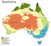 Most of Australia is semi-arid or desert, making it the world's driest continent
. The movement of the monsoon trough
is linked to the peak of the rainy season within the continent. Northern portions of the continent see the most rainfall, which is concentrated in the summer months. During winter and spring southern Australia sees its maximum rainfall. The interior desert sees its greatest rainfall during spring and summer. The wettest spot is Mount Bellenden Ker
in the north-east of the country records an average of 8000 millimetres (315 in) per year, with over 12000 millimetres (472.4 in) of rain recorded in the year 2000. While Melbourne is thought of as being much rainier than Sydney, Sydney receives an average of 1213 mm (47.8 in) of rain per year compared to Melbourne's 648 mm (25.5 in).
in lands bordering the Mediterranean sea
lasts from October through March, with November and December typically the wettest months. Summer rainfall across the continent evaporates completely into the warm atmosphere, leaving winter precipitation to be the source of groundwater for Europe. Mesoscale
rain systems during the rainy season track south and eastward over the Mediterranean, with western portions of the sea experiencing 20 percent more rainfall than eastern sections of the sea.
The European Monsoon (more commonly known as the Return of the Westerlies) is the result of a resurgence of westerly winds from the Atlantic, where they become loaded with wind and rain. These Westerly winds are a common phenomenon during the European winter, but they ease as Spring approaches in late March and through April and May. The winds pick up again in June, which is why this phenomenon is also referred to as "the return of the westerlies". The rain usually arrives in two waves, at the beginning of June and again in mid to late June. The European monsoon is not a monsoon in the traditional sense in that it doesn't meet all the requirements to be classified as such. Instead the Return of the Westerlies is more regarded as a conveyor belt that delivers a series of low pressure centres to Western Europe
where they create unseasonable weather. These storms generally feature significantly lower than average temperatures, fierce rain or hail, thunder and strong winds. The Return of the Westerlies affects Europe's Northern Atlantic
coastline, more precisely Ireland
, Great Britain
, the Benelux countries
, Western Germany
, Northern France and parts of Scandinavia
.
There are cycles seen within the rainfall data from Northern Europe between Great Britain and Germany, which are seen at a 16 year interval. Southern Europe experiences a 22-year cycle in rainfall variation. Other smaller term cycles are seen at 10-12 year and 6-7 year periods within the rainfall record. Places with significant impact by acid rain across the continent include most of eastern Europe from Poland
northward into Scandinavia
.
, the northwestern state of Sonora
, the northern altiplano, and also significant portions of the southern altiplano. Rainfall in these regions averages between 300 and 600 mm (11.8 and 23.6 in) per year, with lower amounts across Baja California Norte. Average rainfall totals are between 600 and 1000 mm (23.6 and 39.4 in) in most of the major populated areas of the southern altiplano, including Mexico City
and Guadalajara
. Low-lying areas along the Gulf of Mexico
receive in excess of 1000 millimetres (39.4 in) of rainfall in an average year, with the wettest region being the southeastern state of Tabasco, which typically receives approximately 2000 millimetres (78.7 in) of rainfall on an annual basis. Parts of the northern altiplano, highlands and high peaks in the Sierra Madre Occidental
and the Sierra Madre Oriental
occasionally receive significant snowfalls.
Mexico has pronounced wet and dry seasons. Most of the country experiences a rainy season from June to mid-October and significantly less rain during the remainder of the year. February and July generally are the driest and wettest months, respectively. Mexico City
, for example, receives an average of only 5 millimetre (0.196850393700787 in) of rain during February but more than 160 millimetres (6.3 in) in July. Coastal areas, especially those along the Gulf of Mexico, experience the largest amounts of rain in September. Tabasco
typically records more than 300 millimetres (11.8 in) of rain during that month. A small coastal area of northwestern coastal Mexico around Tijuana
has a Mediterranean climate
with considerable coastal fog and a rainy season that occurs in winter.
Tropical cyclones track near and along the western Mexican coastline primarily between the months of July and September. These storms enhance the monsoon circulation over northwest Mexico and the southwest United States
. On an average basis, eastern Pacific tropical cyclones contribute about one-third of the annual rainfall along the Mexican Riviera, and up to one-half of the rainfall seen annually across Baja California Sur. Mexico is twice as likely (18% of the basin total) to be impacted by a Pacific tropical cyclone on its west coast than an Atlantic tropical cyclone on its east coast (9% of the basin total). The three most struck states in Mexico in the 50 years at the end of the 20th century were Baja California Sur
, Sinaloa
, and Quintana Roo
.
Late summer
and fall extratropical cyclone
s bring a majority of the precipitation
which falls across western, southern, and southeast Alaska
annually. During the fall, winter, and spring
, Pacific storm systems bring most of Hawaii
and the western United States much of their precipitation. Nor'easters moving up the East coast bring cold season precipitation to the Mid-Atlantic and New England states. During the summer, the Southwest monsoon
combined with Gulf of California
and Gulf of Mexico
moisture moving around the subtropical ridge
in the Atlantic ocean bring the promise of afternoon and evening thunderstorms to the southern tier of the country as well as the Great Plains
. Tropical cyclone
s enhance precipitation across southern sections of the country, as well as Puerto Rico
, the United States Virgin Islands
, the Northern Mariana Islands
, Guam
, and American Samoa
. Over the top of the ridge, the jet stream brings a summer precipitation maximum to the Great Lakes
. Large thunderstorm areas known as mesoscale convective complex
es move through the Plains, Midwest, and Great Lakes during the warm season, contributing up to 10% of the annual precipitation to the region.
The El Niño-Southern Oscillation
affects the precipitation distribution, by altering rainfall patterns across the West, Midwest, the Southeast, and throughout the tropics. There is also evidence that global warming
is leading to increased precipitation to the eastern portions of North America, while droughts are becoming more frequent in the tropics and subtropics. The eastern half of the contiguous United States east of the 98th meridian
, the mountains of the Pacific Northwest
, and the Sierra Nevada range are the wetter portions of the nation, with average rainfall exceeding 30 inches (762 mm) per year. The drier areas are the Desert Southwest, Great Basin, valleys of northeast Arizona, eastern Utah, central Wyoming, eastern Oregon and Washington and the northeast of the Olympic Peninsula
. Mount Waialeale
on the island of Kauaʻi in the Hawaiian Islands
averages more than 11680 millimetres (459.8 in) of rain over the last 32 years, with a record 17340 millimetres (682.7 in) in 1982. Its summit is considered one of the rainiest spots on earth. It has been promoted in tourist literature for many years as the wettest spot in the world.
, a town situated in Chocó
, Colombia
, is probably the place with the largest measured rainfall in the world, averaging 13,300 mm per year (523.6 in). In fact, the whole Department of Chocó is extraordinarily humid. Tutunendo, a small town situated in the same department, is one of the wettest places on earth, averaging 11,394 mm per year (448 in); in 1974 the town received 26,303 mm (86 ft 3½ in), the largest annual rainfall measured in Colombia. Unlike Cherrapunji, which receives most of its rainfall between April and September, Tutunendo receives rain almost uniformly distributed throughout the year. The months of January and February have somewhat less frequent storms. On average, Tutunendo has 280 days with rainfall per year. Over ⅔ of the rain (68%) falls during the night. The average relative humidity is 90% and the average temperature is 26.4 °C. Quibdó
, the capital of Chocó, receives the most rain in the world among cities with over 100,000 inhabitants: 9000 millimetres (354.3 in) per year. Storms in Chocó can drop 500 mm (19.7 in) of rainfall in a day. This amount is more than falls in many cities in a year's time. The Andes
mountain range blocks Pacific
moisture that arrives in that continent, resulting in a desertlike climate just downwind across western Argentina.
s and fog
, the humidity
, and the rates of precipitation. The extra heat provided by the UHI leads to greater upward motion, which can induce additional shower and thunderstorm activity. Rainfall rates downwind of cities are increased between 48% and 116%. Partly as a result of this warming, monthly rainfall is about 28% greater between 20 miles (32.2 km) to 40 miles (64.4 km) downwind of cities, compared with upwind. Some cities show a total precipitation increase of 51%. Using satellite images, researchers discovered that city climates have a noticeable influence on plant growing seasons up to 10 kilometers (6 mi) away from a city's edges. Growing seasons in 70 cities in eastern North America were about 15 days longer in urban areas compared to rural areas outside of a city's influence.
Rain
Rain is liquid precipitation, as opposed to non-liquid kinds of precipitation such as snow, hail and sleet. Rain requires the presence of a thick layer of the atmosphere to have temperatures above the melting point of water near and above the Earth's surface...
fall distribution across different regions of the planet Earth
Earth
Earth is the third planet from the Sun, and the densest and fifth-largest of the eight planets in the Solar System. It is also the largest of the Solar System's four terrestrial planets...
. In mountainous areas, heavy precipitation is possible where upslope flow is maximized within windward sides of the terrain at elevation. On the leeward side of mountains, desert climates can exist due to the dry air caused by compressional heating. The movement of the monsoon trough
Monsoon trough
The monsoon trough is that portion of the Intertropical Convergence Zone which extends into or through a monsoon circulation, as depicted by a line on a weather map showing the locations of minimum sea level pressure, and as such, is a convergence zone between the wind patterns of the southern and...
, or intertropical convergence zone
Intertropical Convergence Zone
The Intertropical Convergence Zone , known by sailors as The Doldrums, is the area encircling the earth near the equator where winds originating in the northern and southern hemispheres come together....
, brings rainy seasons
Wet season
The the wet season, or rainy season, is the time of year, covering one or more months, when most of the average annual rainfall in a region occurs. The term green season is also sometimes used as a euphemism by tourist authorities. Areas with wet seasons are dispersed across portions of the...
to savannah
Savannah
Savannah or savanna is a type of grassland.It can also mean:-People:* Savannah King, a Canadian freestyle swimmer* Savannah Outen, a singer who gained popularity on You Tube...
clime
Clime
The seven climes was a notion of dividing the Earth into zones in Classical Antiquity....
s. The urban heat island
Urban heat island
An urban heat island is a metropolitan area which is significantly warmer than its surrounding rural areas. The phenomenon was first investigated and described by Luke Howard in the 1810s, although he was not the one to name the phenomenon. The temperature difference usually is larger at night...
effect leads to increased rainfall, both in amounts and intensity, downwind of cities. Global warming
Global warming
Global warming refers to the rising average temperature of Earth's atmosphere and oceans and its projected continuation. In the last 100 years, Earth's average surface temperature increased by about with about two thirds of the increase occurring over just the last three decades...
is also causing changes in the precipitation pattern globally, including wetter conditions across eastern North America
North America
North America is a continent wholly within the Northern Hemisphere and almost wholly within the Western Hemisphere. It is also considered a northern subcontinent of the Americas...
and drier conditions in the tropics. Precipitation is a major component of the water cycle
Water cycle
The water cycle, also known as the hydrologic cycle or H2O cycle, describes the continuous movement of water on, above and below the surface of the Earth. Water can change states among liquid, vapor, and solid at various places in the water cycle...
, and is responsible for depositing most of the fresh water
Fresh Water
Fresh Water is the debut album by Australian rock and blues singer Alison McCallum, released in 1972. Rare for an Australian artist at the time, it came in a gatefold sleeve...
on the planet
Planet
A planet is a celestial body orbiting a star or stellar remnant that is massive enough to be rounded by its own gravity, is not massive enough to cause thermonuclear fusion, and has cleared its neighbouring region of planetesimals.The term planet is ancient, with ties to history, science,...
. Approximately 505000 cubic kilometres (121,155.9 cu mi) of water falls as precipitation each year; 398000 cubic kilometres (95,485.3 cu mi) of it over the ocean
Ocean
An ocean is a major body of saline water, and a principal component of the hydrosphere. Approximately 71% of the Earth's surface is covered by ocean, a continuous body of water that is customarily divided into several principal oceans and smaller seas.More than half of this area is over 3,000...
s. Given the Earth
Earth
Earth is the third planet from the Sun, and the densest and fifth-largest of the eight planets in the Solar System. It is also the largest of the Solar System's four terrestrial planets...
's surface area, that means the globally averaged annual precipitation is 990 millimetres (39 in). Climate
Climate
Climate encompasses the statistics of temperature, humidity, atmospheric pressure, wind, rainfall, atmospheric particle count and other meteorological elemental measurements in a given region over long periods...
classification systems such as the Köppen climate classification
Köppen climate classification
The Köppen climate classification is one of the most widely used climate classification systems. It was first published by Crimea German climatologist Wladimir Köppen in 1884, with several later modifications by Köppen himself, notably in 1918 and 1936...
system use average annual rainfall to help differentiate between differing climate regimes.
Most of Australia is semi-arid or desert, making it the world's driest continent
Continent
A continent is one of several very large landmasses on Earth. They are generally identified by convention rather than any strict criteria, with seven regions commonly regarded as continents—they are : Asia, Africa, North America, South America, Antarctica, Europe, and Australia.Plate tectonics is...
. Australia's rainfall is mainly regulated by the movement of the monsoon trough during the summer rainy season, with lesser amounts falling during the winter and spring in its southernmost sections. The northern half of Africa is primarily desert
Desert
A desert is a landscape or region that receives an extremely low amount of precipitation, less than enough to support growth of most plants. Most deserts have an average annual precipitation of less than...
or arid
Arid
A region is said to be arid when it is characterized by a severe lack of available water, to the extent of hindering or even preventing the growth and development of plant and animal life...
, containing the Sahara
Sahara
The Sahara is the world's second largest desert, after Antarctica. At over , it covers most of Northern Africa, making it almost as large as Europe or the United States. The Sahara stretches from the Red Sea, including parts of the Mediterranean coasts, to the outskirts of the Atlantic Ocean...
, which central Africa (known as Sub-Saharan Africa
Sub-Saharan Africa
Sub-Saharan Africa as a geographical term refers to the area of the African continent which lies south of the Sahara. A political definition of Sub-Saharan Africa, instead, covers all African countries which are fully or partially located south of the Sahara...
) sees an annual rainy season regulated by the movement of the intertropical convergence zone or monsoon trough. Across Asia, a large annual rainfall minimum, composed primarily of deserts, stretches from the Gobi desert
Gobi Desert
The Gobi is a large desert region in Asia. It covers parts of northern and northwestern China, and of southern Mongolia. The desert basins of the Gobi are bounded by the Altai Mountains and the grasslands and steppes of Mongolia on the north, by the Hexi Corridor and Tibetan Plateau to the...
in Mongolia west-southwest through Pakistan and Iran into the Arabian desert
Arabian Desert
The Arabian Desert is a vast desert wilderness stretching from Yemen to the Persian Gulf and Oman to Jordan and Iraq. It occupies most of the Arabian Peninsula, with an area of...
in Saudi Arabia. In Asia, rainfall is favored across its southern portion from India east and northeast across the Philippines and southern China into Japan due to the monsoon
Monsoon
Monsoon is traditionally defined as a seasonal reversing wind accompanied by corresponding changes in precipitation, but is now used to describe seasonal changes in atmospheric circulation and precipitation associated with the asymmetric heating of land and sea...
advecting moisture primarily from the Indian Ocean
Indian Ocean
The Indian Ocean is the third largest of the world's oceanic divisions, covering approximately 20% of the water on the Earth's surface. It is bounded on the north by the Indian Subcontinent and Arabian Peninsula ; on the west by eastern Africa; on the east by Indochina, the Sunda Islands, and...
into the region. Similar, but weaker, monsoon circulations are present over North America
North America
North America is a continent wholly within the Northern Hemisphere and almost wholly within the Western Hemisphere. It is also considered a northern subcontinent of the Americas...
and Australia
Australia
Australia , officially the Commonwealth of Australia, is a country in the Southern Hemisphere comprising the mainland of the Australian continent, the island of Tasmania, and numerous smaller islands in the Indian and Pacific Oceans. It is the world's sixth-largest country by total area...
. In Europe
Europe
Europe is, by convention, one of the world's seven continents. Comprising the westernmost peninsula of Eurasia, Europe is generally 'divided' from Asia to its east by the watershed divides of the Ural and Caucasus Mountains, the Ural River, the Caspian and Black Seas, and the waterways connecting...
, the wettest regions are in the Alps and downwind of bodies of water. Within North America, the drier areas of the United States are the Desert Southwest, Great Basin, valleys of northeast Arizona, eastern Utah, central Wyoming, and the Willamette Valley. Other dry regions within the continent are far northern Canada and the Sonoran Desert of northwest Mexico. The Pacific Northwest United States, the Rockies of British Columbia, and the coastal ranges of Alaska are the wettest locations in North America. The equatorial region near the Intertropical Convergence Zone
Intertropical Convergence Zone
The Intertropical Convergence Zone , known by sailors as The Doldrums, is the area encircling the earth near the equator where winds originating in the northern and southern hemispheres come together....
(ITCZ), or monsoon trough
Monsoon trough
The monsoon trough is that portion of the Intertropical Convergence Zone which extends into or through a monsoon circulation, as depicted by a line on a weather map showing the locations of minimum sea level pressure, and as such, is a convergence zone between the wind patterns of the southern and...
, is the wettest portion of the world's continents. Annually, the rain belt within the tropics marches northward by August, then moves back southward into the Southern Hemisphere
Southern Hemisphere
The Southern Hemisphere is the part of Earth that lies south of the equator. The word hemisphere literally means 'half ball' or "half sphere"...
by February and March.
Role in Köppen climate classification
The Köppen classification depends on average monthly values of temperature and precipitation. The most commonly used form of the Köppen classification has five primary types labeled A through E. Specifically, the primary types are A, tropical; B, dry; C, mild mid-latitude; D, cold mid-latitude; and E, polar. The five primary classifications can be further divided into secondary classifications such as rain forest, monsoon
Monsoon
Monsoon is traditionally defined as a seasonal reversing wind accompanied by corresponding changes in precipitation, but is now used to describe seasonal changes in atmospheric circulation and precipitation associated with the asymmetric heating of land and sea...
, tropical savanna, humid subtropical, humid continental, oceanic climate
Oceanic climate
An oceanic climate, also called marine west coast climate, maritime climate, Cascadian climate and British climate for Köppen climate classification Cfb and subtropical highland for Köppen Cfb or Cwb, is a type of climate typically found along the west coasts at the middle latitudes of some of the...
, Mediterranean climate
Mediterranean climate
A Mediterranean climate is the climate typical of most of the lands in the Mediterranean Basin, and is a particular variety of subtropical climate...
, steppe
Steppe
In physical geography, steppe is an ecoregion, in the montane grasslands and shrublands and temperate grasslands, savannas, and shrublands biomes, characterized by grassland plains without trees apart from those near rivers and lakes...
, subarctic climate
Subarctic climate
The subarctic climate is a climate characterized by long, usually very cold winters, and short, cool to mild summers. It is found on large landmasses, away from the moderating effects of an ocean, generally at latitudes from 50° to 70°N poleward of the humid continental climates...
, tundra
Tundra
In physical geography, tundra is a biome where the tree growth is hindered by low temperatures and short growing seasons. The term tundra comes through Russian тундра from the Kildin Sami word tūndâr "uplands," "treeless mountain tract." There are three types of tundra: Arctic tundra, alpine...
, polar ice cap
Polar ice cap
A polar ice cap is a high latitude region of a planet or natural satellite that is covered in ice. There are no requirements with respect to size or composition for a body of ice to be termed a polar ice cap, nor any geological requirement for it to be over land; only that it must be a body of...
, and desert
Desert
A desert is a landscape or region that receives an extremely low amount of precipitation, less than enough to support growth of most plants. Most deserts have an average annual precipitation of less than...
.
Rain forests are characterized by high rainfall, with definitions setting minimum normal annual rainfall between 1750 millimetres (68.9 in) and 2000 millimetres (78.7 in). A tropical savanna is a grassland
Grassland
Grasslands are areas where the vegetation is dominated by grasses and other herbaceous plants . However, sedge and rush families can also be found. Grasslands occur naturally on all continents except Antarctica...
biome
Biome
Biomes are climatically and geographically defined as similar climatic conditions on the Earth, such as communities of plants, animals, and soil organisms, and are often referred to as ecosystems. Some parts of the earth have more or less the same kind of abiotic and biotic factors spread over a...
located in semi-arid
Semi-arid
A semi-arid climate or steppe climate describes climatic regions that receive precipitation below potential evapotranspiration, but not extremely...
to semi-humid climate regions of subtropical and tropical latitudes, with rainfall between 750 millimetres (29.5 in) and 1270 millimetres (50 in) a year. They are widespread on Africa
Africa
Africa is the world's second largest and second most populous continent, after Asia. At about 30.2 million km² including adjacent islands, it covers 6% of the Earth's total surface area and 20.4% of the total land area...
, and are also found in India
India
India , officially the Republic of India , is a country in South Asia. It is the seventh-largest country by geographical area, the second-most populous country with over 1.2 billion people, and the most populous democracy in the world...
, the northern parts of South America
South America
South America is a continent situated in the Western Hemisphere, mostly in the Southern Hemisphere, with a relatively small portion in the Northern Hemisphere. The continent is also considered a subcontinent of the Americas. It is bordered on the west by the Pacific Ocean and on the north and east...
, Malaysia, and Australia
Australia
Australia , officially the Commonwealth of Australia, is a country in the Southern Hemisphere comprising the mainland of the Australian continent, the island of Tasmania, and numerous smaller islands in the Indian and Pacific Oceans. It is the world's sixth-largest country by total area...
. The humid subtropical climate zone where winter rainfall (and sometimes snowfall) is associated with large storm
Storm
A storm is any disturbed state of an astronomical body's atmosphere, especially affecting its surface, and strongly implying severe weather...
s that the westerlies
Westerlies
The Westerlies, anti-trades, or Prevailing Westerlies, are the prevailing winds in the middle latitudes between 30 and 60 degrees latitude, blowing from the high pressure area in the horse latitudes towards the poles. These prevailing winds blow from the west to the east, and steer extratropical...
steer from west to east. Most summer rainfall occurs during thunderstorm
Thunderstorm
A thunderstorm, also known as an electrical storm, a lightning storm, thundershower or simply a storm is a form of weather characterized by the presence of lightning and its acoustic effect on the Earth's atmosphere known as thunder. The meteorologically assigned cloud type associated with the...
s and from occasional tropical cyclone
Tropical cyclone
A tropical cyclone is a storm system characterized by a large low-pressure center and numerous thunderstorms that produce strong winds and heavy rain. Tropical cyclones strengthen when water evaporated from the ocean is released as the saturated air rises, resulting in condensation of water vapor...
s. Humid subtropical climates lie on the east side continents, roughly between latitude
Latitude
In geography, the latitude of a location on the Earth is the angular distance of that location south or north of the Equator. The latitude is an angle, and is usually measured in degrees . The equator has a latitude of 0°, the North pole has a latitude of 90° north , and the South pole has a...
s 20° and 40° degrees away from the equator.
An oceanic (or maritime) climate is typically found along the west coasts at the middle latitudes of all the world's continents, bordering cool oceans, as well as southeastern Australia
Australia
Australia , officially the Commonwealth of Australia, is a country in the Southern Hemisphere comprising the mainland of the Australian continent, the island of Tasmania, and numerous smaller islands in the Indian and Pacific Oceans. It is the world's sixth-largest country by total area...
, and is accompanied by plentiful precipitation year round. The Mediterranean climate regime resembles the climate of the lands in the Mediterranean Basin
Mediterranean Basin
In biogeography, the Mediterranean Basin refers to the lands around the Mediterranean Sea that have a Mediterranean climate, with mild, rainy winters and hot, dry summers, which supports characteristic Mediterranean forests, woodlands, and scrub vegetation...
, parts of western North America
North America
North America is a continent wholly within the Northern Hemisphere and almost wholly within the Western Hemisphere. It is also considered a northern subcontinent of the Americas...
, parts of Western
Western Australia
Western Australia is a state of Australia, occupying the entire western third of the Australian continent. It is bounded by the Indian Ocean to the north and west, the Great Australian Bight and Indian Ocean to the south, the Northern Territory to the north-east and South Australia to the south-east...
and South Australia
South Australia
South Australia is a state of Australia in the southern central part of the country. It covers some of the most arid parts of the continent; with a total land area of , it is the fourth largest of Australia's six states and two territories.South Australia shares borders with all of the mainland...
, in southwestern South Africa
South Africa
The Republic of South Africa is a country in southern Africa. Located at the southern tip of Africa, it is divided into nine provinces, with of coastline on the Atlantic and Indian oceans...
and in parts of central Chile
Chile
Chile ,officially the Republic of Chile , is a country in South America occupying a long, narrow coastal strip between the Andes mountains to the east and the Pacific Ocean to the west. It borders Peru to the north, Bolivia to the northeast, Argentina to the east, and the Drake Passage in the far...
. The climate is characterized by hot, dry summers and cool, wet winters. A steppe is a dry grassland
Grassland
Grasslands are areas where the vegetation is dominated by grasses and other herbaceous plants . However, sedge and rush families can also be found. Grasslands occur naturally on all continents except Antarctica...
. Subarctic climates are cold with continuous permafrost
Permafrost
In geology, permafrost, cryotic soil or permafrost soil is soil at or below the freezing point of water for two or more years. Ice is not always present, as may be in the case of nonporous bedrock, but it frequently occurs and it may be in amounts exceeding the potential hydraulic saturation of...
and little precipitation.
Africa
Desert
A desert is a landscape or region that receives an extremely low amount of precipitation, less than enough to support growth of most plants. Most deserts have an average annual precipitation of less than...
or arid
Arid
A region is said to be arid when it is characterized by a severe lack of available water, to the extent of hindering or even preventing the growth and development of plant and animal life...
, containing the Sahara
Sahara
The Sahara is the world's second largest desert, after Antarctica. At over , it covers most of Northern Africa, making it almost as large as Europe or the United States. The Sahara stretches from the Red Sea, including parts of the Mediterranean coasts, to the outskirts of the Atlantic Ocean...
, while its southern areas contain both savanna
Savanna
A savanna, or savannah, is a grassland ecosystem characterized by the trees being sufficiently small or widely spaced so that the canopy does not close. The open canopy allows sufficient light to reach the ground to support an unbroken herbaceous layer consisting primarily of C4 grasses.Some...
plain
Plain
In geography, a plain is land with relatively low relief, that is flat or gently rolling. Prairies and steppes are types of plains, and the archetype for a plain is often thought of as a grassland, but plains in their natural state may also be covered in shrublands, woodland and forest, or...
s, and its central portion contains very dense jungle
Jungle
A Jungle is an area of land in the tropics overgrown with dense vegetation.The word jungle originates from the Sanskrit word jangala which referred to uncultivated land. Although the Sanskrit word refers to "dry land", it has been suggested that an Anglo-Indian interpretation led to its...
(rainforest
Rainforest
Rainforests are forests characterized by high rainfall, with definitions based on a minimum normal annual rainfall of 1750-2000 mm...
) regions. The equatorial region near the Intertropical Convergence Zone
Intertropical Convergence Zone
The Intertropical Convergence Zone , known by sailors as The Doldrums, is the area encircling the earth near the equator where winds originating in the northern and southern hemispheres come together....
is the wettest portion of the continent. Annually, the rain belt across the country marches northward into Sub-Saharan Africa
Sub-Saharan Africa
Sub-Saharan Africa as a geographical term refers to the area of the African continent which lies south of the Sahara. A political definition of Sub-Saharan Africa, instead, covers all African countries which are fully or partially located south of the Sahara...
by August, then moves back southward into south-central Africa by March. Mesoscale convective systems which form in tandem with tropical wave
Tropical wave
Tropical waves, easterly waves, or tropical easterly waves, also known as African easterly waves in the Atlantic region, are a type of atmospheric trough, an elongated area of relatively low air pressure, oriented north to south, which move from east to west across the tropics causing areas of...
s that move along the Intertropical Convergence Zone during the summer months become the seedlings for tropical cyclones which form in the northern Atlantic and northeast Pacific oceans. Areas with a savannah climate in Sub-Saharan Africa
Sub-Saharan Africa
Sub-Saharan Africa as a geographical term refers to the area of the African continent which lies south of the Sahara. A political definition of Sub-Saharan Africa, instead, covers all African countries which are fully or partially located south of the Sahara...
, such as Ghana
Ghana
Ghana , officially the Republic of Ghana, is a country located in West Africa. It is bordered by Côte d'Ivoire to the west, Burkina Faso to the north, Togo to the east, and the Gulf of Guinea to the south...
, Burkina Faso
Burkina Faso
Burkina Faso – also known by its short-form name Burkina – is a landlocked country in west Africa. It is surrounded by six countries: Mali to the north, Niger to the east, Benin to the southeast, Togo and Ghana to the south, and Côte d'Ivoire to the southwest.Its size is with an estimated...
, Darfur
Darfur
Darfur is a region in western Sudan. An independent sultanate for several hundred years, it was incorporated into Sudan by Anglo-Egyptian forces in 1916. The region is divided into three federal states: West Darfur, South Darfur, and North Darfur...
, Eritrea
Eritrea
Eritrea , officially the State of Eritrea, is a country in the Horn of Africa. Eritrea derives it's name from the Greek word Erethria, meaning 'red land'. The capital is Asmara. It is bordered by Sudan in the west, Ethiopia in the south, and Djibouti in the southeast...
, Ethiopia
Ethiopia
Ethiopia , officially known as the Federal Democratic Republic of Ethiopia, is a country located in the Horn of Africa. It is the second-most populous nation in Africa, with over 82 million inhabitants, and the tenth-largest by area, occupying 1,100,000 km2...
, and Botswana
Botswana
Botswana, officially the Republic of Botswana , is a landlocked country located in Southern Africa. The citizens are referred to as "Batswana" . Formerly the British protectorate of Bechuanaland, Botswana adopted its new name after becoming independent within the Commonwealth on 30 September 1966...
have a distinct rainy season.
Within of Madagascar
Madagascar
The Republic of Madagascar is an island country located in the Indian Ocean off the southeastern coast of Africa...
, trade winds bring moisture up the eastern slopes of the island, which is deposited as rainfall, and brings drier downsloped winds to areas south and west leaving the western sections of the island in a rain shadow. This leads to significantly more rainfall over northeast sections of the island than the southwestern portions of Madagascar. Southern Africa receives most of its rainfall from summer convective storms and with extratropical cyclone
Extratropical cyclone
Extratropical cyclones, sometimes called mid-latitude cyclones or wave cyclones, are a group of cyclones defined as synoptic scale low pressure weather systems that occur in the middle latitudes of the Earth having neither tropical nor polar characteristics, and are connected with fronts and...
s moving through the Westerlies
Westerlies
The Westerlies, anti-trades, or Prevailing Westerlies, are the prevailing winds in the middle latitudes between 30 and 60 degrees latitude, blowing from the high pressure area in the horse latitudes towards the poles. These prevailing winds blow from the west to the east, and steer extratropical...
. Once a decade, tropical cyclones lead to excessive rainfall across the region.
Asia
A large annual rainfall minimum, composed primarily of deserts, stretches from the Gobi desertGobi Desert
The Gobi is a large desert region in Asia. It covers parts of northern and northwestern China, and of southern Mongolia. The desert basins of the Gobi are bounded by the Altai Mountains and the grasslands and steppes of Mongolia on the north, by the Hexi Corridor and Tibetan Plateau to the...
in Mongolia west-southwest through Pakistan and Iran into the Arabian desert
Arabian Desert
The Arabian Desert is a vast desert wilderness stretching from Yemen to the Persian Gulf and Oman to Jordan and Iraq. It occupies most of the Arabian Peninsula, with an area of...
in Saudi Arabia. Rainfall around the continent is favored across its southern portion from India east and northeast across the Philippines and southern China into Japan due to the monsoon
Monsoon
Monsoon is traditionally defined as a seasonal reversing wind accompanied by corresponding changes in precipitation, but is now used to describe seasonal changes in atmospheric circulation and precipitation associated with the asymmetric heating of land and sea...
advecting moisture primarily from the Indian Ocean
Indian Ocean
The Indian Ocean is the third largest of the world's oceanic divisions, covering approximately 20% of the water on the Earth's surface. It is bounded on the north by the Indian Subcontinent and Arabian Peninsula ; on the west by eastern Africa; on the east by Indochina, the Sunda Islands, and...
into the region. The monsoon trough can reach as far north as the 40th parallel
40th parallel north
The 40th parallel north is a circle of latitude that is 40 degrees north of the Earth's equatorial plane. It crosses Europe, the Mediterranean Sea, Asia, the Pacific Ocean, North America, and the Atlantic Ocean....
in East Asia during August before moving southward thereafter. Its poleward progression is accelerated by the onset of the summer monsoon which is characterized by the development of lower air pressure (a thermal low
Thermal low
Thermal lows, or heat lows, are non-frontal low-pressure areas that occur over the continents in the subtropics such as near the Sonoran Desert, the Mexican plateau, Sahara, South America over northwest Argentina, Australia, the Iberian peninsula, and Tibetan plateau during the warm season as the...
) over the warmest part of Asia. Cherrapunji
Cherrapunji
Cherrapunji , is a subdivisional town in the East Khasi Hills district in the Indian state of Meghalaya. It is credited as being the second wettest place on Earth...
, situated on the southern slopes of the Eastern Himalaya in Shillong
Shillong
-Connectivity:Although well connected by road, Shillong has no rail connection and a proper air connection. Umroi Airport exists but has only limited flights.-Roadways:Shillong is well connected by roads with all major north eastern states...
, India
India
India , officially the Republic of India , is a country in South Asia. It is the seventh-largest country by geographical area, the second-most populous country with over 1.2 billion people, and the most populous democracy in the world...
is one of the wettest places on Earth, with an average annual rainfall of 11,430 mm (450 in). The highest recorded rainfall in a single year was 22,987 mm (904.9 in) in 1861. The 38-year average at Mawsynram
Mawsynram
Mawsynram is a village in the East Khasi Hills district of Meghalaya state in north-eastern India, 56 kilometers from Shillong. It is reportedly the wettest place on Earth, with an annual rainfall of...
, Meghalaya
Meghalaya
Meghalaya is a state in north-eastern India. The word "Meghalaya" literally means the Abode of Clouds in Sanskrit and other Indic languages. Meghalaya is a hilly strip in the eastern part of the country about 300 km long and 100 km wide, with a total area of about 8,700 sq mi . The...
, India
India
India , officially the Republic of India , is a country in South Asia. It is the seventh-largest country by geographical area, the second-most populous country with over 1.2 billion people, and the most populous democracy in the world...
is 11,873 mm (467.4 in). Lower rainfall maxima are found on the Mediterranean and Black Sea coasts of Turkey and the mountains of Tajikistan.
Australia
Continent
A continent is one of several very large landmasses on Earth. They are generally identified by convention rather than any strict criteria, with seven regions commonly regarded as continents—they are : Asia, Africa, North America, South America, Antarctica, Europe, and Australia.Plate tectonics is...
. The movement of the monsoon trough
Monsoon trough
The monsoon trough is that portion of the Intertropical Convergence Zone which extends into or through a monsoon circulation, as depicted by a line on a weather map showing the locations of minimum sea level pressure, and as such, is a convergence zone between the wind patterns of the southern and...
is linked to the peak of the rainy season within the continent. Northern portions of the continent see the most rainfall, which is concentrated in the summer months. During winter and spring southern Australia sees its maximum rainfall. The interior desert sees its greatest rainfall during spring and summer. The wettest spot is Mount Bellenden Ker
Mount Bellenden Ker
Mount Bellenden Ker is the second highest mountain in Queensland, Australia. It is named after the botanist John Bellenden Ker Gawler. Located 60 km south of Cairns near Babinda, it is adjacent to Mount Bartle Frere, the state's highest peak, part of the Bellenden Ker Range which is also...
in the north-east of the country records an average of 8000 millimetres (315 in) per year, with over 12000 millimetres (472.4 in) of rain recorded in the year 2000. While Melbourne is thought of as being much rainier than Sydney, Sydney receives an average of 1213 mm (47.8 in) of rain per year compared to Melbourne's 648 mm (25.5 in).
Europe
On an annual basis, rainfall across the continent is favored within the Alps, and from Slovenia southward to the western coast of Greece. Other maxima exist in western Georgia, northwest Spain, western Great Britain, and western Norway. The maxima along the eastern coasts of water bodies is due to the westerly wind flow which dominates across the continent. A bulk of the precipitation across the Alps falls between March and November. The wet seasonWet season
The the wet season, or rainy season, is the time of year, covering one or more months, when most of the average annual rainfall in a region occurs. The term green season is also sometimes used as a euphemism by tourist authorities. Areas with wet seasons are dispersed across portions of the...
in lands bordering the Mediterranean sea
Mediterranean Sea
The Mediterranean Sea is a sea connected to the Atlantic Ocean surrounded by the Mediterranean region and almost completely enclosed by land: on the north by Anatolia and Europe, on the south by North Africa, and on the east by the Levant...
lasts from October through March, with November and December typically the wettest months. Summer rainfall across the continent evaporates completely into the warm atmosphere, leaving winter precipitation to be the source of groundwater for Europe. Mesoscale
Mesoscale meteorology
Mesoscale meteorology is the study of weather systems smaller than synoptic scale systems but larger than microscale and storm-scale cumulus systems. Horizontal dimensions generally range from around 5 kilometers to several hundred kilometers...
rain systems during the rainy season track south and eastward over the Mediterranean, with western portions of the sea experiencing 20 percent more rainfall than eastern sections of the sea.
The European Monsoon (more commonly known as the Return of the Westerlies) is the result of a resurgence of westerly winds from the Atlantic, where they become loaded with wind and rain. These Westerly winds are a common phenomenon during the European winter, but they ease as Spring approaches in late March and through April and May. The winds pick up again in June, which is why this phenomenon is also referred to as "the return of the westerlies". The rain usually arrives in two waves, at the beginning of June and again in mid to late June. The European monsoon is not a monsoon in the traditional sense in that it doesn't meet all the requirements to be classified as such. Instead the Return of the Westerlies is more regarded as a conveyor belt that delivers a series of low pressure centres to Western Europe
Western Europe
Western Europe is a loose term for the collection of countries in the western most region of the European continents, though this definition is context-dependent and carries cultural and political connotations. One definition describes Western Europe as a geographic entity—the region lying in the...
where they create unseasonable weather. These storms generally feature significantly lower than average temperatures, fierce rain or hail, thunder and strong winds. The Return of the Westerlies affects Europe's Northern Atlantic
Northern Europe
Northern Europe is the northern part or region of Europe. Northern Europe typically refers to the seven countries in the northern part of the European subcontinent which includes Denmark, Estonia, Latvia, Lithuania, Norway, Finland and Sweden...
coastline, more precisely Ireland
Ireland
Ireland is an island to the northwest of continental Europe. It is the third-largest island in Europe and the twentieth-largest island on Earth...
, Great Britain
Great Britain
Great Britain or Britain is an island situated to the northwest of Continental Europe. It is the ninth largest island in the world, and the largest European island, as well as the largest of the British Isles...
, the Benelux countries
Benelux
The Benelux is an economic union in Western Europe comprising three neighbouring countries, Belgium, the Netherlands, and Luxembourg. These countries are located in northwestern Europe between France and Germany...
, Western Germany
Western Germany
The geographic term Western Germany is used to describe a region in the west of Germany. The exact area defined by the term is not constant, but it usually includes, but does not have the borders of, North Rhine-Westphalia and Hesse...
, Northern France and parts of Scandinavia
Scandinavia
Scandinavia is a cultural, historical and ethno-linguistic region in northern Europe that includes the three kingdoms of Denmark, Norway and Sweden, characterized by their common ethno-cultural heritage and language. Modern Norway and Sweden proper are situated on the Scandinavian Peninsula,...
.
There are cycles seen within the rainfall data from Northern Europe between Great Britain and Germany, which are seen at a 16 year interval. Southern Europe experiences a 22-year cycle in rainfall variation. Other smaller term cycles are seen at 10-12 year and 6-7 year periods within the rainfall record. Places with significant impact by acid rain across the continent include most of eastern Europe from Poland
Poland
Poland , officially the Republic of Poland , is a country in Central Europe bordered by Germany to the west; the Czech Republic and Slovakia to the south; Ukraine, Belarus and Lithuania to the east; and the Baltic Sea and Kaliningrad Oblast, a Russian exclave, to the north...
northward into Scandinavia
Scandinavia
Scandinavia is a cultural, historical and ethno-linguistic region in northern Europe that includes the three kingdoms of Denmark, Norway and Sweden, characterized by their common ethno-cultural heritage and language. Modern Norway and Sweden proper are situated on the Scandinavian Peninsula,...
.
Canada
Precipitation across Canada is highest in the mountain ranges in the western portions due to onshore flow bringing Pacific moisture into the mountains, which is subsequently forced to lift up their slopes and deposit significant precipitation, primarily between August and May. Mesoscale convective systems are common mid-summer near the central border with the United States from the Prairie provinces eastward towards the Great Lakes. Southeastern sections of the country are also wet, due to the development of extratropical cyclones along the east coast of the continent which move northward into Atlantic Canada. During the summer and fall months, tropical cyclones from the Atlantic basin are also possible across Atlantic Canada. Amounts decrease as one works farther inland from the Pacific and Atlantic coasts, and from south to north towards the Arctic.Mexico
Rainfall varies widely both by location and season. Arid or semiarid conditions are encountered in the Baja California PeninsulaBaja California Peninsula
The Baja California peninsula , is a peninsula in northwestern Mexico. Its land mass separates the Pacific Ocean from the Gulf of California. The Peninsula extends from Mexicali, Baja California in the north to Cabo San Lucas, Baja California Sur in the south.The total area of the Baja California...
, the northwestern state of Sonora
Sonora
Sonora officially Estado Libre y Soberano de Sonora is one of the 31 states which, with the Federal District, comprise the 32 Federal Entities of Mexico. It is divided into 72 municipalities; the capital city is Hermosillo....
, the northern altiplano, and also significant portions of the southern altiplano. Rainfall in these regions averages between 300 and 600 mm (11.8 and 23.6 in) per year, with lower amounts across Baja California Norte. Average rainfall totals are between 600 and 1000 mm (23.6 and 39.4 in) in most of the major populated areas of the southern altiplano, including Mexico City
Mexico City
Mexico City is the Federal District , capital of Mexico and seat of the federal powers of the Mexican Union. It is a federal entity within Mexico which is not part of any one of the 31 Mexican states but belongs to the federation as a whole...
and Guadalajara
Guadalajara, Jalisco
Guadalajara is the capital of the Mexican state of Jalisco, and the seat of the municipality of Guadalajara. The city is located in the central region of Jalisco in the western-pacific area of Mexico. With a population of 1,564,514 it is Mexico's second most populous municipality...
. Low-lying areas along the Gulf of Mexico
Gulf of Mexico
The Gulf of Mexico is a partially landlocked ocean basin largely surrounded by the North American continent and the island of Cuba. It is bounded on the northeast, north and northwest by the Gulf Coast of the United States, on the southwest and south by Mexico, and on the southeast by Cuba. In...
receive in excess of 1000 millimetres (39.4 in) of rainfall in an average year, with the wettest region being the southeastern state of Tabasco, which typically receives approximately 2000 millimetres (78.7 in) of rainfall on an annual basis. Parts of the northern altiplano, highlands and high peaks in the Sierra Madre Occidental
Sierra Madre Occidental
The Sierra Madre Occidental is a mountain range in western Mexico.-Setting:The range runs north to south, from just south of the Sonora–Arizona border southeast through eastern Sonora, western Chihuahua, Sinaloa, Durango, Zacatecas, Nayarit, Jalisco, Aguascalientes to Guanajuato, where it joins...
and the Sierra Madre Oriental
Sierra Madre Oriental
The Sierra Madre Oriental is a mountain range in northeastern Mexico.-Setting:Spanning the Sierra Madre Oriental runs from Coahuila south through Nuevo León, southwest Tamaulipas, San Luis Potosí, Querétaro, and Hidalgo to northern Puebla, where it joins with the east-west running Eje Volcánico...
occasionally receive significant snowfalls.
Mexico has pronounced wet and dry seasons. Most of the country experiences a rainy season from June to mid-October and significantly less rain during the remainder of the year. February and July generally are the driest and wettest months, respectively. Mexico City
Mexico City
Mexico City is the Federal District , capital of Mexico and seat of the federal powers of the Mexican Union. It is a federal entity within Mexico which is not part of any one of the 31 Mexican states but belongs to the federation as a whole...
, for example, receives an average of only 5 millimetre (0.196850393700787 in) of rain during February but more than 160 millimetres (6.3 in) in July. Coastal areas, especially those along the Gulf of Mexico, experience the largest amounts of rain in September. Tabasco
Tabasco
Tabasco officially Estado Libre y Soberano de Tabasco is one of the 31 states which, with the Federal District, comprise the 32 Federal Entities of Mexico. It is divided in 17 municipalities and its capital city is Villahermosa....
typically records more than 300 millimetres (11.8 in) of rain during that month. A small coastal area of northwestern coastal Mexico around Tijuana
Tijuana
Tijuana is the largest city on the Baja California Peninsula and center of the Tijuana metropolitan area, part of the international San Diego–Tijuana metropolitan area. An industrial and financial center of Mexico, Tijuana exerts a strong influence on economics, education, culture, art, and politics...
has a Mediterranean climate
Mediterranean climate
A Mediterranean climate is the climate typical of most of the lands in the Mediterranean Basin, and is a particular variety of subtropical climate...
with considerable coastal fog and a rainy season that occurs in winter.
Tropical cyclones track near and along the western Mexican coastline primarily between the months of July and September. These storms enhance the monsoon circulation over northwest Mexico and the southwest United States
United States
The United States of America is a federal constitutional republic comprising fifty states and a federal district...
. On an average basis, eastern Pacific tropical cyclones contribute about one-third of the annual rainfall along the Mexican Riviera, and up to one-half of the rainfall seen annually across Baja California Sur. Mexico is twice as likely (18% of the basin total) to be impacted by a Pacific tropical cyclone on its west coast than an Atlantic tropical cyclone on its east coast (9% of the basin total). The three most struck states in Mexico in the 50 years at the end of the 20th century were Baja California Sur
Baja California Sur
Baja California Sur , is one of the 31 states which, with the Federal District, comprise the 32 Federal Entities of Mexico. Before becoming a state on October 8, 1974, the area was known as the South Territory of Baja California. It has an area of , or 3.57% of the land mass of Mexico and comprises...
, Sinaloa
Sinaloa
Sinaloa officially Estado Libre y Soberano de Sinaloa is one of the 31 states which, with the Federal District, comprise the 32 Federal Entities of Mexico. It is divided in 18 municipalities and its capital city is Culiacán Rosales....
, and Quintana Roo
Quintana Roo
Quintana Roo officially Estado Libre y Soberano de Quintana Roo is one of the 31 states which, with the Federal District, comprise the 32 Federal Entities of Mexico. It is divided in 10 municipalities and its capital city is Chetumal....
.
United States
Late summer
Summer
Summer is the warmest of the four temperate seasons, between spring and autumn. At the summer solstice, the days are longest and the nights are shortest, with day-length decreasing as the season progresses after the solstice...
and fall extratropical cyclone
Extratropical cyclone
Extratropical cyclones, sometimes called mid-latitude cyclones or wave cyclones, are a group of cyclones defined as synoptic scale low pressure weather systems that occur in the middle latitudes of the Earth having neither tropical nor polar characteristics, and are connected with fronts and...
s bring a majority of the precipitation
Precipitation (meteorology)
In meteorology, precipitation In meteorology, precipitation In meteorology, precipitation (also known as one of the classes of hydrometeors, which are atmospheric water phenomena is any product of the condensation of atmospheric water vapor that falls under gravity. The main forms of precipitation...
which falls across western, southern, and southeast Alaska
Alaska
Alaska is the largest state in the United States by area. It is situated in the northwest extremity of the North American continent, with Canada to the east, the Arctic Ocean to the north, and the Pacific Ocean to the west and south, with Russia further west across the Bering Strait...
annually. During the fall, winter, and spring
Spring (season)
Spring is one of the four temperate seasons, the transition period between winter and summer. Spring and "springtime" refer to the season, and broadly to ideas of rebirth, renewal and regrowth. The specific definition of the exact timing of "spring" varies according to local climate, cultures and...
, Pacific storm systems bring most of Hawaii
Hawaii
Hawaii is the newest of the 50 U.S. states , and is the only U.S. state made up entirely of islands. It is the northernmost island group in Polynesia, occupying most of an archipelago in the central Pacific Ocean, southwest of the continental United States, southeast of Japan, and northeast of...
and the western United States much of their precipitation. Nor'easters moving up the East coast bring cold season precipitation to the Mid-Atlantic and New England states. During the summer, the Southwest monsoon
Monsoon
Monsoon is traditionally defined as a seasonal reversing wind accompanied by corresponding changes in precipitation, but is now used to describe seasonal changes in atmospheric circulation and precipitation associated with the asymmetric heating of land and sea...
combined with Gulf of California
Gulf of California
The Gulf of California is a body of water that separates the Baja California Peninsula from the Mexican mainland...
and Gulf of Mexico
Gulf of Mexico
The Gulf of Mexico is a partially landlocked ocean basin largely surrounded by the North American continent and the island of Cuba. It is bounded on the northeast, north and northwest by the Gulf Coast of the United States, on the southwest and south by Mexico, and on the southeast by Cuba. In...
moisture moving around the subtropical ridge
Subtropical ridge
The subtropical ridge is a significant belt of high pressure situated around the latitudes of 30°N in the Northern Hemisphere and 30°S in the Southern Hemisphere. It is characterized by mostly calm winds, which acts to reduce air quality under its axis by causing fog overnight, and haze during...
in the Atlantic ocean bring the promise of afternoon and evening thunderstorms to the southern tier of the country as well as the Great Plains
Great Plains
The Great Plains are a broad expanse of flat land, much of it covered in prairie, steppe and grassland, which lies west of the Mississippi River and east of the Rocky Mountains in the United States and Canada. This area covers parts of the U.S...
. Tropical cyclone
Tropical cyclone
A tropical cyclone is a storm system characterized by a large low-pressure center and numerous thunderstorms that produce strong winds and heavy rain. Tropical cyclones strengthen when water evaporated from the ocean is released as the saturated air rises, resulting in condensation of water vapor...
s enhance precipitation across southern sections of the country, as well as Puerto Rico
Puerto Rico
Puerto Rico , officially the Commonwealth of Puerto Rico , is an unincorporated territory of the United States, located in the northeastern Caribbean, east of the Dominican Republic and west of both the United States Virgin Islands and the British Virgin Islands.Puerto Rico comprises an...
, the United States Virgin Islands
United States Virgin Islands
The Virgin Islands of the United States are a group of islands in the Caribbean that are an insular area of the United States. The islands are geographically part of the Virgin Islands archipelago and are located in the Leeward Islands of the Lesser Antilles.The U.S...
, the Northern Mariana Islands
Northern Mariana Islands
The Northern Mariana Islands, officially the Commonwealth of the Northern Mariana Islands , is a commonwealth in political union with the United States, occupying a strategic region of the western Pacific Ocean. It consists of 15 islands about three-quarters of the way from Hawaii to the Philippines...
, Guam
Guam
Guam is an organized, unincorporated territory of the United States located in the western Pacific Ocean. It is one of five U.S. territories with an established civilian government. Guam is listed as one of 16 Non-Self-Governing Territories by the Special Committee on Decolonization of the United...
, and American Samoa
American Samoa
American Samoa is an unincorporated territory of the United States located in the South Pacific Ocean, southeast of the sovereign state of Samoa...
. Over the top of the ridge, the jet stream brings a summer precipitation maximum to the Great Lakes
Great Lakes
The Great Lakes are a collection of freshwater lakes located in northeastern North America, on the Canada – United States border. Consisting of Lakes Superior, Michigan, Huron, Erie, and Ontario, they form the largest group of freshwater lakes on Earth by total surface, coming in second by volume...
. Large thunderstorm areas known as mesoscale convective complex
Mesoscale Convective Complex
A mesoscale convective complex is a unique kind of mesoscale convective system which is defined by characteristics observed in infrared satellite imagery. They are long-lived, nocturnal in formation and commonly contain heavy rainfall, wind, hail, lightning and possibly tornadoes.-Size:A...
es move through the Plains, Midwest, and Great Lakes during the warm season, contributing up to 10% of the annual precipitation to the region.
The El Niño-Southern Oscillation
El Niño-Southern Oscillation
El Niño/La Niña-Southern Oscillation, or ENSO, is a quasiperiodic climate pattern that occurs across the tropical Pacific Ocean roughly every five years...
affects the precipitation distribution, by altering rainfall patterns across the West, Midwest, the Southeast, and throughout the tropics. There is also evidence that global warming
Global warming
Global warming refers to the rising average temperature of Earth's atmosphere and oceans and its projected continuation. In the last 100 years, Earth's average surface temperature increased by about with about two thirds of the increase occurring over just the last three decades...
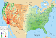
is leading to increased precipitation to the eastern portions of North America, while droughts are becoming more frequent in the tropics and subtropics. The eastern half of the contiguous United States east of the 98th meridian
98th meridian west
The meridian 98° west of Greenwich is a line of longitude that extends from the North Pole across the Arctic Ocean, North America, the Pacific Ocean, the Southern Ocean, and Antarctica to the South Pole....
, the mountains of the Pacific Northwest
Pacific Northwest
The Pacific Northwest is a region in northwestern North America, bounded by the Pacific Ocean to the west and, loosely, by the Rocky Mountains on the east. Definitions of the region vary and there is no commonly agreed upon boundary, even among Pacific Northwesterners. A common concept of the...
, and the Sierra Nevada range are the wetter portions of the nation, with average rainfall exceeding 30 inches (762 mm) per year. The drier areas are the Desert Southwest, Great Basin, valleys of northeast Arizona, eastern Utah, central Wyoming, eastern Oregon and Washington and the northeast of the Olympic Peninsula
Olympic Peninsula
The Olympic Peninsula is the large arm of land in western Washington state of the USA, that lies across Puget Sound from Seattle. It is bounded on the west by the Pacific Ocean, the north by the Strait of Juan de Fuca, and the east by Puget Sound. Cape Alava, the westernmost point in the contiguous...
. Mount Waialeale
Mount Waialeale
Mount Waialeale at an elevation of , is a shield volcano and the second highest point on the island of Kauai in the Hawaiian Islands. Averaging more than of rain a year since 1912, with a record in 1982, its summit is one of the rainiest spots on earth....
on the island of Kauaʻi in the Hawaiian Islands
Hawaiian Islands
The Hawaiian Islands are an archipelago of eight major islands, several atolls, numerous smaller islets, and undersea seamounts in the North Pacific Ocean, extending some 1,500 miles from the island of Hawaii in the south to northernmost Kure Atoll...
averages more than 11680 millimetres (459.8 in) of rain over the last 32 years, with a record 17340 millimetres (682.7 in) in 1982. Its summit is considered one of the rainiest spots on earth. It has been promoted in tourist literature for many years as the wettest spot in the world.
South America
The annual average rainfall maxima across the continent lie across the northwest from northwest Brazil into northern Peru, Colombia, and Ecuador, then along the Atlantic coast of the Guyanas and far northern Brazil, as well as within the southern half of Chile. LloróLloró
Lloró is a municipality and town in the Chocó Department, Colombia. It holds the world record for highest average annual precipitation, estimated at 523.6 inches . If accurate, that would make it the wettest place in the world. The Spanish verb llorar "to cry" can also be used as a metaphor for...
, a town situated in Chocó
Chocó Department
Chocó is a department of Colombia known for its large Afro-Colombian population. It is in the west of the country, and is the only Colombian department to have coastlines on both the Pacific Ocean and the Atlantic Ocean. It also has all of Colombia's border with Panama. Its capital is...
, Colombia
Colombia
Colombia, officially the Republic of Colombia , is a unitary constitutional republic comprising thirty-two departments. The country is located in northwestern South America, bordered to the east by Venezuela and Brazil; to the south by Ecuador and Peru; to the north by the Caribbean Sea; to the...
, is probably the place with the largest measured rainfall in the world, averaging 13,300 mm per year (523.6 in). In fact, the whole Department of Chocó is extraordinarily humid. Tutunendo, a small town situated in the same department, is one of the wettest places on earth, averaging 11,394 mm per year (448 in); in 1974 the town received 26,303 mm (86 ft 3½ in), the largest annual rainfall measured in Colombia. Unlike Cherrapunji, which receives most of its rainfall between April and September, Tutunendo receives rain almost uniformly distributed throughout the year. The months of January and February have somewhat less frequent storms. On average, Tutunendo has 280 days with rainfall per year. Over ⅔ of the rain (68%) falls during the night. The average relative humidity is 90% and the average temperature is 26.4 °C. Quibdó
Quibdó
Quibdó is the capital city of Chocó Department, in western Colombia. The municipality of Quibdó has an area of 3,337.5 km² and a population of 100,000 mainly consisting of Afro Colombians and Zambo Colombians. Quibdo serves a a receptor for those persons affected by the Colombian armed...
, the capital of Chocó, receives the most rain in the world among cities with over 100,000 inhabitants: 9000 millimetres (354.3 in) per year. Storms in Chocó can drop 500 mm (19.7 in) of rainfall in a day. This amount is more than falls in many cities in a year's time. The Andes
Andes
The Andes is the world's longest continental mountain range. It is a continual range of highlands along the western coast of South America. This range is about long, about to wide , and of an average height of about .Along its length, the Andes is split into several ranges, which are separated...
mountain range blocks Pacific
Pacific Ocean
The Pacific Ocean is the largest of the Earth's oceanic divisions. It extends from the Arctic in the north to the Southern Ocean in the south, bounded by Asia and Australia in the west, and the Americas in the east.At 165.2 million square kilometres in area, this largest division of the World...
moisture that arrives in that continent, resulting in a desertlike climate just downwind across western Argentina.
Urban heat island impacts
Aside from the effect on temperature, urban heat islands (UHIs) can produce secondary effects on local meteorology, including the altering of local wind patterns, the development of cloudCloud
A cloud is a visible mass of liquid droplets or frozen crystals made of water and/or various chemicals suspended in the atmosphere above the surface of a planetary body. They are also known as aerosols. Clouds in Earth's atmosphere are studied in the cloud physics branch of meteorology...
s and fog
Fog
Fog is a collection of water droplets or ice crystals suspended in the air at or near the Earth's surface. While fog is a type of stratus cloud, the term "fog" is typically distinguished from the more generic term "cloud" in that fog is low-lying, and the moisture in the fog is often generated...
, the humidity
Humidity
Humidity is a term for the amount of water vapor in the air, and can refer to any one of several measurements of humidity. Formally, humid air is not "moist air" but a mixture of water vapor and other constituents of air, and humidity is defined in terms of the water content of this mixture,...
, and the rates of precipitation. The extra heat provided by the UHI leads to greater upward motion, which can induce additional shower and thunderstorm activity. Rainfall rates downwind of cities are increased between 48% and 116%. Partly as a result of this warming, monthly rainfall is about 28% greater between 20 miles (32.2 km) to 40 miles (64.4 km) downwind of cities, compared with upwind. Some cities show a total precipitation increase of 51%. Using satellite images, researchers discovered that city climates have a noticeable influence on plant growing seasons up to 10 kilometers (6 mi) away from a city's edges. Growing seasons in 70 cities in eastern North America were about 15 days longer in urban areas compared to rural areas outside of a city's influence.
See also
- China tropical cyclone rainfall climatologyChina tropical cyclone rainfall climatologyChina is a mountainous country, which leads to rapid dissipation of cyclones that move inland as well as significant amounts of rain from those dissipating cyclones. Typhoon Nina caused the collapse of two huge reservoirs and ten smaller dams when 1062 mm/41.81 inches fell in Henan...
- Mexico tropical cyclone rainfall climatologyMexico tropical cyclone rainfall climatologyMexico tropical cyclone rainfall climatology discusses precipitation characteristics of tropical cyclones that have struck Mexico over the years. One-third of the annual rainfall received along the Mexican Riviera and up to half of the rainfall received in Baja California Sur is directly...
- Typhoons in the PhilippinesTyphoons in the PhilippinesTyphoons in the Philippines refer in general to tropical cyclones that enter the Philippine area of responsibility and affect the Philippines. Locally they are called bagyo...
- United States rainfall climatologyUnited States rainfall climatologyThe characteristics of United States rainfall climatology differ significantly across the United States and its possessions. Late summer and fall extratropical cyclones bring a majority of the precipitation which falls across western, southern, and southeast Alaska annually...