

United States rainfall climatology
Encyclopedia
United States
The United States of America is a federal constitutional republic comprising fifty states and a federal district...
and its possessions. Late summer
Summer
Summer is the warmest of the four temperate seasons, between spring and autumn. At the summer solstice, the days are longest and the nights are shortest, with day-length decreasing as the season progresses after the solstice...
and fall extratropical cyclone
Extratropical cyclone
Extratropical cyclones, sometimes called mid-latitude cyclones or wave cyclones, are a group of cyclones defined as synoptic scale low pressure weather systems that occur in the middle latitudes of the Earth having neither tropical nor polar characteristics, and are connected with fronts and...
s bring a majority of the precipitation
Precipitation (meteorology)
In meteorology, precipitation In meteorology, precipitation In meteorology, precipitation (also known as one of the classes of hydrometeors, which are atmospheric water phenomena is any product of the condensation of atmospheric water vapor that falls under gravity. The main forms of precipitation...
which falls across western, southern, and southeast Alaska
Alaska
Alaska is the largest state in the United States by area. It is situated in the northwest extremity of the North American continent, with Canada to the east, the Arctic Ocean to the north, and the Pacific Ocean to the west and south, with Russia further west across the Bering Strait...
annually. During the fall, winter, and spring
Spring (season)
Spring is one of the four temperate seasons, the transition period between winter and summer. Spring and "springtime" refer to the season, and broadly to ideas of rebirth, renewal and regrowth. The specific definition of the exact timing of "spring" varies according to local climate, cultures and...
, Pacific storm systems bring most of Hawaii
Hawaii
Hawaii is the newest of the 50 U.S. states , and is the only U.S. state made up entirely of islands. It is the northernmost island group in Polynesia, occupying most of an archipelago in the central Pacific Ocean, southwest of the continental United States, southeast of Japan, and northeast of...
and the western United States much of their precipitation ,During 1992. Nor'easters moving up the East coast bring cold season precipitation to the Mid-Atlantic and New England states. Lake-effect snows add to precipitation potential downwind of the Great Lakes
Great Lakes
The Great Lakes are a collection of freshwater lakes located in northeastern North America, on the Canada – United States border. Consisting of Lakes Superior, Michigan, Huron, Erie, and Ontario, they form the largest group of freshwater lakes on Earth by total surface, coming in second by volume...
, as well as Great Salt Lake
Great Salt Lake
The Great Salt Lake, located in the northern part of the U.S. state of Utah, is the largest salt water lake in the western hemisphere, the fourth-largest terminal lake in the world. In an average year the lake covers an area of around , but the lake's size fluctuates substantially due to its...
and the Finger Lakes
Finger Lakes
The Finger Lakes are a pattern of lakes in the west-central section of Upstate New York in the United States. They are a popular tourist destination. The lakes are long and thin , each oriented roughly on a north-south axis. The two longest, Cayuga Lake and Seneca Lake, are among the deepest in...
during the cold season. The snow to liquid ratio across the contiguous United States averages 13:1, meaning 13 inches (330.2 mm) of snow melts down to 1 inches (25.4 mm) of water.
During the summer, the Southwest monsoon
Monsoon
Monsoon is traditionally defined as a seasonal reversing wind accompanied by corresponding changes in precipitation, but is now used to describe seasonal changes in atmospheric circulation and precipitation associated with the asymmetric heating of land and sea...
combined with Gulf of California
Gulf of California
The Gulf of California is a body of water that separates the Baja California Peninsula from the Mexican mainland...
and Gulf of Mexico
Gulf of Mexico
The Gulf of Mexico is a partially landlocked ocean basin largely surrounded by the North American continent and the island of Cuba. It is bounded on the northeast, north and northwest by the Gulf Coast of the United States, on the southwest and south by Mexico, and on the southeast by Cuba. In...
moisture moving around the subtropical ridge
Subtropical ridge
The subtropical ridge is a significant belt of high pressure situated around the latitudes of 30°N in the Northern Hemisphere and 30°S in the Southern Hemisphere. It is characterized by mostly calm winds, which acts to reduce air quality under its axis by causing fog overnight, and haze during...
in the Atlantic ocean bring the promise of afternoon and evening air-mass thunderstorm
Air-mass thunderstorm
An air-mass thunderstorm, also called an "ordinary", "single cell", or "garden variety" thunderstorm, is a thunderstorm that is generally weak and usually not severe. These storms form in environments with low Convective Available Potential Energy values, low wind shear, and low helicity values...
s to the southern tier of the country as well as the Great Plains
Great Plains
The Great Plains are a broad expanse of flat land, much of it covered in prairie, steppe and grassland, which lies west of the Mississippi River and east of the Rocky Mountains in the United States and Canada. This area covers parts of the U.S...
. Equatorward of the subtropical ridge, tropical cyclone
Tropical cyclone
A tropical cyclone is a storm system characterized by a large low-pressure center and numerous thunderstorms that produce strong winds and heavy rain. Tropical cyclones strengthen when water evaporated from the ocean is released as the saturated air rises, resulting in condensation of water vapor...
s enhance precipitation across southern and eastern sections of the country, as well as Puerto Rico
Puerto Rico
Puerto Rico , officially the Commonwealth of Puerto Rico , is an unincorporated territory of the United States, located in the northeastern Caribbean, east of the Dominican Republic and west of both the United States Virgin Islands and the British Virgin Islands.Puerto Rico comprises an...
, the United States Virgin Islands
United States Virgin Islands
The Virgin Islands of the United States are a group of islands in the Caribbean that are an insular area of the United States. The islands are geographically part of the Virgin Islands archipelago and are located in the Leeward Islands of the Lesser Antilles.The U.S...
, the Northern Mariana Islands
Northern Mariana Islands
The Northern Mariana Islands, officially the Commonwealth of the Northern Mariana Islands , is a commonwealth in political union with the United States, occupying a strategic region of the western Pacific Ocean. It consists of 15 islands about three-quarters of the way from Hawaii to the Philippines...
, Guam
Guam
Guam is an organized, unincorporated territory of the United States located in the western Pacific Ocean. It is one of five U.S. territories with an established civilian government. Guam is listed as one of 16 Non-Self-Governing Territories by the Special Committee on Decolonization of the United...
, and American Samoa
American Samoa
American Samoa is an unincorporated territory of the United States located in the South Pacific Ocean, southeast of the sovereign state of Samoa...
. Over the top of the ridge, the jet stream brings a summer precipitation maximum to the Great Lakes
Great Lakes
The Great Lakes are a collection of freshwater lakes located in northeastern North America, on the Canada – United States border. Consisting of Lakes Superior, Michigan, Huron, Erie, and Ontario, they form the largest group of freshwater lakes on Earth by total surface, coming in second by volume...
. Large thunderstorm areas known as mesoscale convective complex
Mesoscale Convective Complex
A mesoscale convective complex is a unique kind of mesoscale convective system which is defined by characteristics observed in infrared satellite imagery. They are long-lived, nocturnal in formation and commonly contain heavy rainfall, wind, hail, lightning and possibly tornadoes.-Size:A...
es move through the Plains, Midwest, and Great Lakes during the warm season, contributing up to 10% of the annual precipitation to the region.
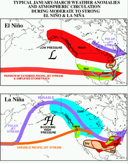
The El Niño-Southern Oscillation
El Niño-Southern Oscillation
El Niño/La Niña-Southern Oscillation, or ENSO, is a quasiperiodic climate pattern that occurs across the tropical Pacific Ocean roughly every five years...
affects the precipitation distribution, by altering rainfall patterns across the West, Midwest, the Southeast, and throughout the tropics. There is also evidence that global warming
Global warming
Global warming refers to the rising average temperature of Earth's atmosphere and oceans and its projected continuation. In the last 100 years, Earth's average surface temperature increased by about with about two thirds of the increase occurring over just the last three decades...
is leading to increased precipitation to the eastern portions of North America, while droughts are becoming more frequent in the tropics and subtropics.
General
The eastern half of the contiguous United States east of the 98th meridian98th meridian west
The meridian 98° west of Greenwich is a line of longitude that extends from the North Pole across the Arctic Ocean, North America, the Pacific Ocean, the Southern Ocean, and Antarctica to the South Pole....
, the mountains of the Pacific Northwest
Pacific Northwest
The Pacific Northwest is a region in northwestern North America, bounded by the Pacific Ocean to the west and, loosely, by the Rocky Mountains on the east. Definitions of the region vary and there is no commonly agreed upon boundary, even among Pacific Northwesterners. A common concept of the...
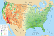
, and the Sierra Nevada range are the wetter portions of the nation, with average rainfall exceeding 30 inches (762 mm) per year. The drier areas are the Desert Southwest, Great Basin, valleys of northeast Arizona, eastern Utah, central Wyoming, and the Willamette Valley. Increased warming within urban heat islands leads to an increase in rainfall downwind of cities.
Alaska
Juneau averages over 50 inches (1,270 mm) of precipitation a year, while other areas in southeast AlaskaAlaska
Alaska is the largest state in the United States by area. It is situated in the northwest extremity of the North American continent, with Canada to the east, the Arctic Ocean to the north, and the Pacific Ocean to the west and south, with Russia further west across the Bering Strait...
receive over 275 inches (6,985 mm). South central Alaska does not get nearly as much rain as the southeast of Alaska, though it does get more snow. On average, Anchorage receives 16 inches (406 mm) of precipitation a year, with around 75 inches (1,905 mm) of snow. The northern coast of the Gulf of Alaska
Gulf of Alaska
The Gulf of Alaska is an arm of the Pacific Ocean defined by the curve of the southern coast of Alaska, stretching from the Alaska Peninsula and Kodiak Island in the west to the Alexander Archipelago in the east, where Glacier Bay and the Inside Passage are found.The entire shoreline of the Gulf is...
receives up to 150 inches (3,810 mm) of precipitation annually. Across western sections of the state, the northern side of the Seward Peninsula is a desert with less than 10 inches (254 mm) of precipitation annually, while some locations between Dillingham and Bethel average around 100 inches (2,540 mm) of precipitation. Inland, often less than 10 inches (254 mm) falls a year, but what precipitation falls during the winter tends to stay throughout the season. La Niña events lead to drier than normal conditions, while El Niño events do not have a correlation towards dry or wet conditions. Precipitation increases by 10 to 40 percent when the Pacific decadal oscillation
Pacific decadal oscillation
The Pacific Decadal Oscillation is a pattern of Pacific climate variability that shifts phases on at least inter-decadal time scale, usually about 20 to 30 years. The PDO is detected as warm or cool surface waters in the Pacific Ocean, north of 20° N...
is positive.
West
From September through May, extratropical cyclone
Extratropical cyclone
Extratropical cyclones, sometimes called mid-latitude cyclones or wave cyclones, are a group of cyclones defined as synoptic scale low pressure weather systems that occur in the middle latitudes of the Earth having neither tropical nor polar characteristics, and are connected with fronts and...
s from the Pacific ocean
Pacific Ocean
The Pacific Ocean is the largest of the Earth's oceanic divisions. It extends from the Arctic in the north to the Southern Ocean in the south, bounded by Asia and Australia in the west, and the Americas in the east.At 165.2 million square kilometres in area, this largest division of the World...
move inland into the region due to a southward migration of the jet stream
Jet stream
Jet streams are fast flowing, narrow air currents found in the atmospheres of some planets, including Earth. The main jet streams are located near the tropopause, the transition between the troposphere and the stratosphere . The major jet streams on Earth are westerly winds...
during the cold season. This shift in the jet stream brings much of the annual precipitation to the region, and also brings the potential for heavy rain events. The West Coast occasionally experiences ocean-effect showers, usually in the form of rain at lower elevations south of the mouth of the Columbia River
Columbia River
The Columbia River is the largest river in the Pacific Northwest region of North America. The river rises in the Rocky Mountains of British Columbia, Canada, flows northwest and then south into the U.S. state of Washington, then turns west to form most of the border between Washington and the state...
. These occur whenever an Arctic air mass from western Canada is drawn westward out over the Pacific Ocean, typically by way of the Fraser Valley
Fraser Valley
The Fraser Valley is the section of the Fraser River basin in southwestern British Columbia downstream of the Fraser Canyon. The term is sometimes used to refer to the Fraser Canyon and stretches upstream from there, but in general British Columbian usage of the term refers to the stretch of the...
, returning shoreward around a center of low pressure. Strong onshore flow is brought into the mountain ranges of the west, focusing significant precipitation into the Rocky Mountains
Rocky Mountains
The Rocky Mountains are a major mountain range in western North America. The Rocky Mountains stretch more than from the northernmost part of British Columbia, in western Canada, to New Mexico, in the southwestern United States...
, with rain shadow
Rain shadow
A rain shadow is a dry area on the lee side of a mountainous area. The mountains block the passage of rain-producing weather systems, casting a "shadow" of dryness behind them. As shown by the diagram to the right, the warm moist air is "pulled" by the prevailing winds over a mountain...
s occurring in the Willamette Valley
Willamette Valley
The Willamette Valley is the most populated region in the state of Oregon of the United States. Located in the state's northwest, the region is surrounded by tall mountain ranges to the east, west and south and the valley's floor is broad, flat and fertile because of Ice Age conditions...
, Great Basin
Great Basin
The Great Basin is the largest area of contiguous endorheic watersheds in North America and is noted for its arid conditions and Basin and Range topography that varies from the North American low point at Badwater Basin to the highest point of the contiguous United States, less than away at the...
, the central valley of California
California
California is a state located on the West Coast of the United States. It is by far the most populous U.S. state, and the third-largest by land area...
, and the lower Colorado River
Colorado River
The Colorado River , is a river in the Southwestern United States and northwestern Mexico, approximately long, draining a part of the arid regions on the western slope of the Rocky Mountains. The watershed of the Colorado River covers in parts of seven U.S. states and two Mexican states...
valley. In general, rainfall amounts are lower on the southern portions of the West coast. The biggest recipients of the precipitation are the coastal ranges such as the Olympic Mountains
Olympic Mountains
The Olympic Mountains is a mountain range on the Olympic Peninsula of western Washington in the United States. The mountains, part of the Pacific Coast Ranges, are not especially high - Mount Olympus is the highest at - but the western slopes of the Olympics rise directly out of the Pacific...
, the Cascades, and the Sierra Nevada range. Lesser amounts fall upon the continental divide
Continental divide
A continental divide is a drainage divide on a continent such that the drainage basin on one side of the divide feeds into one ocean or sea, and the basin on the other side either feeds into a different ocean or sea, or else is endorheic, not connected to the open sea...
. Cold season precipitation into this region is the main supply of water to area rivers, such as the Colorado river and Rio Grande
Rio Grande
The Rio Grande is a river that flows from southwestern Colorado in the United States to the Gulf of Mexico. Along the way it forms part of the Mexico – United States border. Its length varies as its course changes...
, and also acts as the main source of water to people living in this portion of the United States. During El Niño events, increased precipitation is expected in California due to a more southerly, zonal, storm track. California also enters a wet pattern when thunderstorm activity within the tropics associated with the Madden-Julian Oscillation
Madden-Julian oscillation
The Madden–Julian oscillation ' is the largest element of the intraseasonal variability in the tropical atmosphere. It is a large-scale coupling between atmospheric circulation and tropical deep convection...
nears 150E longitude. During La Niña
La Niña
La Niña is a coupled ocean-atmosphere phenomenon that is the counterpart of El Niño as part of the broader El Niño-Southern Oscillation climate pattern. During a period of La Niña, the sea surface temperature across the equatorial Eastern Central Pacific Ocean will be lower than normal by 3–5 °C...
, increased precipitation is diverted into the Pacific Northwest
Pacific Northwest
The Pacific Northwest is a region in northwestern North America, bounded by the Pacific Ocean to the west and, loosely, by the Rocky Mountains on the east. Definitions of the region vary and there is no commonly agreed upon boundary, even among Pacific Northwesterners. A common concept of the...
due to a more northerly storm track.
Lake-effect snow off Great Salt Lake
The southern and southeastern sides of the Great Salt LakeGreat Salt Lake
The Great Salt Lake, located in the northern part of the U.S. state of Utah, is the largest salt water lake in the western hemisphere, the fourth-largest terminal lake in the world. In an average year the lake covers an area of around , but the lake's size fluctuates substantially due to its...
receive significant lake-effect snow. Since the Great Salt Lake never freezes, the lake-effect can affect the weather along the Wasatch Front
Wasatch Front
The Wasatch Front is a metropolitan region in the north-central part of the U.S. state of Utah. It consists of a chain of cities and towns stretched along the Wasatch Range from approximately Santaquin in the south to Brigham City in the north...
year around. The lake-effect largely contributes to the 55 inches (139.7 cm) to 80 inches (203.2 cm) annual snowfall amounts recorded south and east of the lake, with average snowfall amounts exceeding 600 inches (1,524 cm) in the Wasatch Mountains. The snow, which is often very light and dry due to the desert
Desert
A desert is a landscape or region that receives an extremely low amount of precipitation, less than enough to support growth of most plants. Most deserts have an average annual precipitation of less than...
climate
Climate
Climate encompasses the statistics of temperature, humidity, atmospheric pressure, wind, rainfall, atmospheric particle count and other meteorological elemental measurements in a given region over long periods...
, is referred to as "The Greatest Snow on Earth" in the mountains. Lake-effect snow contributes to approximately 6-8 snowfalls per year in Salt Lake City, with approximately 10% of the city's precipitation being contributed by the phenomenon.
North American Monsoon

The North American Monsoon (NAM) occurs from late June or early July into September, originating over Mexico and spreading into the southwest United States by mid-July. This allows the wet season to start in the Southwest during the summer rather than early fall as seen across the remainder of the West. Within the United States, it affects Arizona
Arizona
Arizona ; is a state located in the southwestern region of the United States. It is also part of the western United States and the mountain west. The capital and largest city is Phoenix...
, New Mexico
New Mexico
New Mexico is a state located in the southwest and western regions of the United States. New Mexico is also usually considered one of the Mountain States. With a population density of 16 per square mile, New Mexico is the sixth-most sparsely inhabited U.S...
, Nevada
Nevada
Nevada is a state in the western, mountain west, and southwestern regions of the United States. With an area of and a population of about 2.7 million, it is the 7th-largest and 35th-most populous state. Over two-thirds of Nevada's people live in the Las Vegas metropolitan area, which contains its...
, Utah
Utah
Utah is a state in the Western United States. It was the 45th state to join the Union, on January 4, 1896. Approximately 80% of Utah's 2,763,885 people live along the Wasatch Front, centering on Salt Lake City. This leaves vast expanses of the state nearly uninhabited, making the population the...
, Colorado
Colorado
Colorado is a U.S. state that encompasses much of the Rocky Mountains as well as the northeastern portion of the Colorado Plateau and the western edge of the Great Plains...
, West Texas
West Texas
West Texas is a vernacular term applied to a region in the southwestern quadrant of the United States that primarily encompasses the arid and semi-arid lands in the western portion of the state of Texas....
, and California. The North American monsoon is known to many as the Summer, Southwest, Mexican or Arizona monsoon. It is also sometimes called the Desert Monsoon as a large part of the affected area is desert.
When precipitable water values near 1.32 inches (33.5 mm), brief but often torrential thunderstorms can occur, especially over mountainous terrain. This activity is occasionally enhanced by the passage of retrograding (westward-moving) upper cyclones moving under the subtropical ridge and the entrainment
Entrainment (meteorology)
Entrainment is a phenomenon of the atmosphere which occurs when a turbulent flow captures a non-turbulent flow. It is typically used to refer to the capture of a wind flow of high moisture content, or in the case of tropical cyclones, the capture of drier air....
of the remnants of tropical storms. Tropical cyclones from the eastern Pacific contribute to the moisture within the monsoon system, and bring up to 20 percent of the average annual rainfall to southern California. Flash flood
Flash flood
A flash flood is a rapid flooding of geomorphic low-lying areas—washes, rivers, dry lakes and basins. It may be caused by heavy rain associated with a storm, hurricane, or tropical storm or meltwater from ice or snow flowing over ice sheets or snowfields...
ing is a serious danger during the monsoon season. Dry washes can become raging rivers in an instant, even when no storms are visible as a storm can cause a flash flood tens of miles away. Lightning strikes are also a significant danger. Because it is dangerous to be caught in the open when these storms suddenly appear, many golf courses in Arizona have thunderstorm warning systems.
As much as 45% of the annual rainfall across New Mexico occurs during the summer monsoon. Many desert plants are adapted to take advantage of this brief wet season. Because of the monsoons, the Sonoran
Sonoran Desert
The Sonoran Desert is a North American desert which straddles part of the United States-Mexico border and covers large parts of the U.S. states of Arizona and California and the northwest Mexican states of Sonora, Baja California, and Baja California Sur. It is one of the largest and hottest...
and Mojave
Mojave Desert
The Mojave Desert occupies a significant portion of southeastern California and smaller parts of central California, southern Nevada, southwestern Utah and northwestern Arizona, in the United States...
are considered relatively "wet" when ranked among other deserts such as the Sahara
Sahara
The Sahara is the world's second largest desert, after Antarctica. At over , it covers most of Northern Africa, making it almost as large as Europe or the United States. The Sahara stretches from the Red Sea, including parts of the Mediterranean coasts, to the outskirts of the Atlantic Ocean...
. Monsoons play a vital role in managing wildfire threat by providing moisture at higher elevations and feeding desert streams. Heavy monsoon rain can lead to excess winter plant growth, in turn a summer wildfire risk. A lack of monsoon rain can hamper summer seeding, reducing excess winter plant growth but worsening drought.
Great Plains
Downslope winds off the Rocky mountainsRocky Mountains
The Rocky Mountains are a major mountain range in western North America. The Rocky Mountains stretch more than from the northernmost part of British Columbia, in western Canada, to New Mexico, in the southwestern United States...
can aid in forming the dry line
Dry line
A dry line separates moist air from the Gulf of Mexico and dry desert air from the south-western states . The dry line is an important factor in severe weather frequency in the Great Plains of North America...
. Major drought
Drought
A drought is an extended period of months or years when a region notes a deficiency in its water supply. Generally, this occurs when a region receives consistently below average precipitation. It can have a substantial impact on the ecosystem and agriculture of the affected region...
episodes in the midwestern United States are associated with an amplification of the upper tropospheric
Troposphere
The troposphere is the lowest portion of Earth's atmosphere. It contains approximately 80% of the atmosphere's mass and 99% of its water vapor and aerosols....
subtropical (or monsoon) ridge across the West and Plains, along with a weakening of the western edge of the "Bermuda high". During the summer, a southerly low-level jet draws moisture from the Gulf of Mexico. Additional moisture comes from more local sources, especially transpiring vegetation. Maximum precipitation generally occurs in late spring and early summer, with minimum precipitation in winter. During La Niña events, the storm track shifts far enough northward to bring wetter than normal conditions (in the form of increased snowfall) to the Midwestern states, as well as hot and dry summers.
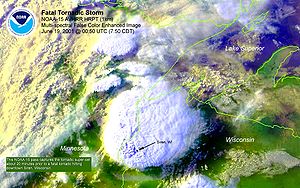
The convective season for the Plains ranges between May and September. Organized systems of thunderstorms known as mesoscale convective system
Mesoscale Convective System
A mesoscale convective system is a complex of thunderstorms that becomes organized on a scale larger than the individual thunderstorms but smaller than extratropical cyclones, and normally persists for several hours or more...
s develop over the region during this period, with a bulk of the activity occurring between midnight and 6 a.m. local time. The time of maximum precipitation during the day gradually varies from late afternoon near the slopes of the Rockies to early morning near the Ohio River valley, in part reflecting the west-to-east propagation of mesoscale convective systems. Mesoscale convective systems bring 30 to 70 percent of the annual warm season rainfall to the Plains. An especially long-lived and well-organized type of mesoscale convective system called a mesoscale convective complex
Mesoscale Convective Complex
A mesoscale convective complex is a unique kind of mesoscale convective system which is defined by characteristics observed in infrared satellite imagery. They are long-lived, nocturnal in formation and commonly contain heavy rainfall, wind, hail, lightning and possibly tornadoes.-Size:A...
produces on average 8% to 18% of the annual warm season rainfall across the Plains and Midwest. Squall line
Squall line
A squall line is a line of severe thunderstorms that can form along or ahead of a cold front. In the early 20th century, the term was used as a synonym for cold front. It contains heavy precipitation, hail, frequent lightning, strong straight-line winds, and possibly tornadoes and waterspouts....
s account for 30% of the large thunderstorm complexes which move through the region.
Cold season
The subtropical jet streamJet stream
Jet streams are fast flowing, narrow air currents found in the atmospheres of some planets, including Earth. The main jet streams are located near the tropopause, the transition between the troposphere and the stratosphere . The major jet streams on Earth are westerly winds...
brings in upper level moisture from the Pacific ocean
Pacific Ocean
The Pacific Ocean is the largest of the Earth's oceanic divisions. It extends from the Arctic in the north to the Southern Ocean in the south, bounded by Asia and Australia in the west, and the Americas in the east.At 165.2 million square kilometres in area, this largest division of the World...
during the cold season. Ahead of storm systems, significant moisture becomes drawn in from the Gulf of Mexico, which increases moisture within the atmospheric column and leads to precipitation ahead of extratropical cyclones. During the El Niño portion of ENSO
Enso
Ensō is a Japanese word meaning "circle" and a concept strongly associated with Zen. Ensō is one of the most common subjects of Japanese calligraphy even though it is a symbol and not a character. It symbolizes the Absolute enlightenment, strength, elegance, the Universe, and the void; it can...
, increased precipitation falls along the Gulf coast and Southeast due to a stronger than normal, and more southerly, polar jet stream. Rare ocean effect snows are possible along the coast of eastern Florida. In the area around Memphis, Tennessee
Memphis, Tennessee
Memphis is a city in the southwestern corner of the U.S. state of Tennessee, and the county seat of Shelby County. The city is located on the 4th Chickasaw Bluff, south of the confluence of the Wolf and Mississippi rivers....
and across the state of Mississippi, there are two rainfall maxima in the winter and spring. Across Georgia and South Carolina, the first of the annual precipitation maxima occurs in late winter, during February or March. Alabama has an annual rainfall maximum in winter or spring and a dry summer.
Warm season
During the summer, the subtropical ridge in the Atlantic oceanAtlantic Ocean
The Atlantic Ocean is the second-largest of the world's oceanic divisions. With a total area of about , it covers approximately 20% of the Earth's surface and about 26% of its water surface area...
strengthens, bringing in increasingly humid air from the warm Atlantic, Caribbean, and Gulf of Mexico. Once precipitable water values exceed 1.25 inches (31.8 mm), afternoon and evening thunderstorms break out at the western periphery of the subtropical ridge across the Southeast on a daily basis. Summer is the time of the second rainfall maximum during the year across Georgia, and the time of the main rainfall maximum in Florida. Evidence shows that increased air pollution is causing rainfall to reach a maximum in intensity during the middle of the week. During the late summer and fall, tropical cyclones move into the region from the Atlantic and Gulf of Mexico, supplying portions of the area with one-quarter of their annual rainfall, on average. Fall is the time of the rainfall minimum across Louisiana. Sometimes, Gulf moisture sneaks up the Front Range
Front Range
The Front Range is a mountain range of the Southern Rocky Mountains of North America located in the north-central portion of the U.S. State of Colorado and southeastern portion of the U.S. State of Wyoming. It is the first mountain range encountered moving west along the 40th parallel north across...
of Rockies as far north as the northern High Plains
High Plains (United States)
The High Plains are a subregion of the Great Plains mostly in the Western United States, but also partly in the Midwest states of Nebraska, Kansas, and South Dakota, generally encompassing the western part of the Great Plains before the region reaches the Rocky Mountains...
, bringing higher dewpoint air into states such as Wyoming
Wyoming
Wyoming is a state in the mountain region of the Western United States. The western two thirds of the state is covered mostly with the mountain ranges and rangelands in the foothills of the Eastern Rocky Mountains, while the eastern third of the state is high elevation prairie known as the High...
and Montana
Montana
Montana is a state in the Western United States. The western third of Montana contains numerous mountain ranges. Smaller, "island ranges" are found in the central third of the state, for a total of 77 named ranges of the Rocky Mountains. This geographical fact is reflected in the state's name,...
.
Cold season
Warm season
Westerlies
The Westerlies, anti-trades, or Prevailing Westerlies, are the prevailing winds in the middle latitudes between 30 and 60 degrees latitude, blowing from the high pressure area in the horse latitudes towards the poles. These prevailing winds blow from the west to the east, and steer extratropical...
that cause precipitation move along jet stream
Jet stream
Jet streams are fast flowing, narrow air currents found in the atmospheres of some planets, including Earth. The main jet streams are located near the tropopause, the transition between the troposphere and the stratosphere . The major jet streams on Earth are westerly winds...
, which migrates north into the region by summer. This also increases the likelihood for severe weather to develop due to stronger upper-level divergence in its vicinity. Mesoscale convective complexes move into the region from the Plains from May through August, with June the peak month for Michigan. These systems contribute about 2% of the annual precipitation for the region. Also, remnants of tropical cyclones occasionally move northward into the region, though their overall contribution to precipitation across the region is minimal. From the spring through the summer, areas near the shores of the relatively cooler Great Lakes develop sea breeze
Sea breeze
A sea-breeze is a wind from the sea that develops over land near coasts. It is formed by increasing temperature differences between the land and water; these create a pressure minimum over the land due to its relative warmth, and forces higher pressure, cooler air from the sea to move inland...
s, which lowers rainfall amounts near the immediate coastline.
Northeast
Burlington, Vermont
Burlington is the largest city in the U.S. state of Vermont and the shire town of Chittenden County. Burlington lies south of the U.S.-Canadian border and some south of Montreal....
has a summer maximum and a winter minimum. In contrast, Portland, Maine
Portland, Maine
Portland is the largest city in Maine and is the county seat of Cumberland County. The 2010 city population was 66,194, growing 3 percent since the census of 2000...
has a fall and winter maximum, with a summer minimum in precipitation. Temporally, a maximum in precipitation is seen around three peak times: 3 a.m., 10 a.m., and 6 p.m. During the summer, the 6 p.m. peak is most pronounced.
Cold season
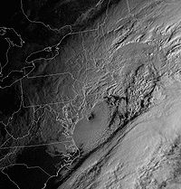
Coastal extratropical cyclones, known as nor'easters, bring a bulk of the wintry precipitation to the region during the cold season as they track parallel to the coastline, forming along the natural temperature gradient of the Gulf streamGulf Stream
The Gulf Stream, together with its northern extension towards Europe, the North Atlantic Drift, is a powerful, warm, and swift Atlantic ocean current that originates at the tip of Florida, and follows the eastern coastlines of the United States and Newfoundland before crossing the Atlantic Ocean...
before moving up the coastline. The Appalachian Mountains
Appalachian Mountains
The Appalachian Mountains #Whether the stressed vowel is or ,#Whether the "ch" is pronounced as a fricative or an affricate , and#Whether the final vowel is the monophthong or the diphthong .), often called the Appalachians, are a system of mountains in eastern North America. The Appalachians...
largely shield New York City
New York City
New York is the most populous city in the United States and the center of the New York Metropolitan Area, one of the most populous metropolitan areas in the world. New York exerts a significant impact upon global commerce, finance, media, art, fashion, research, technology, education, and...
and Philadelphia from picking up any lake-effect snow, though ocean-effect snows are possible near Cape Cod
Cape Cod
Cape Cod, often referred to locally as simply the Cape, is a cape in the easternmost portion of the state of Massachusetts, in the Northeastern United States...
. The Finger Lakes
Finger Lakes
The Finger Lakes are a pattern of lakes in the west-central section of Upstate New York in the United States. They are a popular tourist destination. The lakes are long and thin , each oriented roughly on a north-south axis. The two longest, Cayuga Lake and Seneca Lake, are among the deepest in...
of New York
New York
New York is a state in the Northeastern region of the United States. It is the nation's third most populous state. New York is bordered by New Jersey and Pennsylvania to the south, and by Connecticut, Massachusetts and Vermont to the east...
are long enough for lake-effect precipitation. Lake-effect snow from the Finger Lakes occurs in upstate New York until those lakes freeze over. Bay-effect snows fall downwind of Delaware Bay
Delaware Bay
Delaware Bay is a major estuary outlet of the Delaware River on the Northeast seaboard of the United States whose fresh water mixes for many miles with the waters of the Atlantic Ocean. It is in area. The bay is bordered by the State of New Jersey and the State of Delaware...
, Chesapeake Bay
Chesapeake Bay
The Chesapeake Bay is the largest estuary in the United States. It lies off the Atlantic Ocean, surrounded by Maryland and Virginia. The Chesapeake Bay's drainage basin covers in the District of Columbia and parts of six states: New York, Pennsylvania, Delaware, Maryland, Virginia, and West...
, and Massachusetts Bay
Massachusetts Bay
The Massachusetts Bay, also called Mass Bay, is one of the largest bays of the Atlantic Ocean which forms the distinctive shape of the coastline of the U.S. state of Massachusetts. Its waters extend 65 miles into the Atlantic Ocean. Massachusetts Bay includes the Boston Harbor, Dorchester Bay,...
when the basic criteria are met. Ocean effect snows are possible downwind of the Gulf Stream
Gulf Stream
The Gulf Stream, together with its northern extension towards Europe, the North Atlantic Drift, is a powerful, warm, and swift Atlantic ocean current that originates at the tip of Florida, and follows the eastern coastlines of the United States and Newfoundland before crossing the Atlantic Ocean...
across the Southeast.
Warm season
During the summer and early fall, mesoscale convective systems can move into the area from Canada and the Great Lakes. Tropical cyclones and their remains occasionally move into the region from the south and southwest. Recently, the region has experienced a couple heavy rainfall events that exceeded the 50-year return period, during October 1996 and October 1998, which suggest an increase in heavy rainfall along the coast.Hawaii
Trade wind
The trade winds are the prevailing pattern of easterly surface winds found in the tropics, within the lower portion of the Earth's atmosphere, in the lower section of the troposphere near the Earth's equator...
s and receive much more rainfall; leeward sides are drier and sunnier, with less rain and less cloud cover. In the late winter and spring during El Niño events, drier than average conditions can be expected in Hawaii.
Northern Marianas
The islands have a tropical marine climate moderated by seasonal northeast trade winds. There is a dry season which stretches from December to June, and a rainy season from July to November. SaipanSaipan
Saipan is the largest island of the United States Commonwealth of the Northern Mariana Islands , a chain of 15 tropical islands belonging to the Marianas archipelago in the western Pacific Ocean with a total area of . The 2000 census population was 62,392...
's average annual precipitation is 82.36 inches (2,091.9 mm), with 67 percent falling during the rainy season. Typhoons frequent the island chain, which can lead to excessive rainfall.
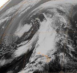
Guam
.jpg)
American Samoa
American Samoa's climate regime is dominated by southeast trade winds. The island dependency is wet, with annual rainfall averaging near 120 inches (3,048 mm) at the airport, with amounts closer to 200 inches (5,080 mm) in other areas. There is a distinct rainy season when tropical cyclones occasionally visit between November and April. The dry season lasts from May to October. During El Niño events, precipitation averages about 10 percent above normal, while La Niña events lead to precipitation amounts which average close to 10 percent below normal.Puerto Rico
There is a pronounced rainy season from April to November across the commonwealth, encompassing the annual hurricane season. Due to the commonwealthCommonwealth
Commonwealth is a traditional English term for a political community founded for the common good. Historically, it has sometimes been synonymous with "republic."More recently it has been used for fraternal associations of some sovereign nations...
's topography, rainfall varies greatly across the island. Pico del Este averages 171.09 inches (4,345.7 mm) of rainfall yearly while Magueyes Island averages only 29.32 inches (744.7 mm) a year. Despite known changes in tropical cyclone
Tropical cyclone
A tropical cyclone is a storm system characterized by a large low-pressure center and numerous thunderstorms that produce strong winds and heavy rain. Tropical cyclones strengthen when water evaporated from the ocean is released as the saturated air rises, resulting in condensation of water vapor...
activity due to changes in the El Niño/Southern Oscillation (ENSO), there is no known relationship between rainfall in Puerto Rico and the ENSO cycle. However, when values of the North Atlantic Oscillation
North Atlantic oscillation
The North Atlantic oscillation is a climatic phenomenon in the North Atlantic Ocean of fluctuations in the difference of atmospheric pressure at sea level between the Icelandic low and the Azores high. Through east-west oscillation motions of the Icelandic low and the Azores high, it controls the...
are high during the winter, precipitation is lower than average for Puerto Rico. There have not been any documented cases of snow falling within Puerto Rico, though occasionally it is brought in from elsewhere as a publicity stunt.
United States Virgin Islands
The climate of the United States Virgin IslandsUnited States Virgin Islands
The Virgin Islands of the United States are a group of islands in the Caribbean that are an insular area of the United States. The islands are geographically part of the Virgin Islands archipelago and are located in the Leeward Islands of the Lesser Antilles.The U.S...
has sustained easterly trade winds through the year. There is a rainy season which lasts from September to November, when hurricanes are more prone to visit the island chain. The average rainfall through the island chain ranges from 51.55 inches (1,309.4 mm) at Annually to 37.79 inches (959.9 mm) at East Hill.
Changes due to global warming

Increasing temperatures tend to increase evaporation which leads to more precipitation. As average global temperatures have risen, average global precipitation has also increased. Precipitation has generally increased over land north of 30°N from 1900 to 2005, but declined over the tropics since the 1970s. Eastern portions of North America have become wetter. There has been an increase in the number of heavy precipitation events over many areas during the past century, as well as an increase since the 1970s in the prevalence of droughts—especially in the tropics and subtropics. Over the contiguous United States, total annual precipitation increased at an average rate of 6.1 percent per century since 1900, with the greatest increases within the East North Central climate region (11.6 percent per century) and the South (11.1 percent). Hawaii was the only region to show a decrease (-9.25 percent). From this excess precipitation, corn losses are expected to increase by US$3 billion (2002 dollars) annually over the next 30 years.
See also
- Climate of the United StatesClimate of the United StatesThe United States includes a wide variety of climate types due to its large size, range of geographic features, and non-contiguous arrangement. In the contiguous United States to the east of the 100th meridian, the climate ranges from humid continental in the north to humid subtropical in the...
- Drought in the United StatesDrought in the United StatesDrought in the United States is similar to that of other portions of the globe. Below normal precipitation leads to drought, which is caused by an above average persistence of high pressure over the drought area...
- Dust BowlDust BowlThe Dust Bowl, or the Dirty Thirties, was a period of severe dust storms causing major ecological and agricultural damage to American and Canadian prairie lands from 1930 to 1936...
- Floods in the United StatesFloods in the United StatesFloods in the United States are generally caused by excessive rainfall, excessive snowmelt, and dam failure. Below is a list of flood events that were of significant impact to the country, between 1901 and 2000.-Heppner Flood – June 1903:...
- List of wettest tropical cyclones in the United States