

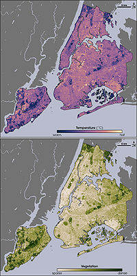
Urban heat island
Encyclopedia

Metropolitan area
The term metropolitan area refers to a region consisting of a densely populated urban core and its less-populated surrounding territories, sharing industry, infrastructure, and housing. A metropolitan area usually encompasses multiple jurisdictions and municipalities: neighborhoods, townships,...
which is significantly warmer than its surrounding rural areas. The phenomenon was first investigated and described by Luke Howard
Luke Howard
Luke Howard FRS was a British manufacturing chemist and an amateur meteorologist with broad interests in science...
in the 1810s, although he was not the one to name the phenomenon. The temperature
Temperature
Temperature is a physical property of matter that quantitatively expresses the common notions of hot and cold. Objects of low temperature are cold, while various degrees of higher temperatures are referred to as warm or hot...
difference usually is larger at night than during the day, and is most apparent when wind
Wind
Wind is the flow of gases on a large scale. On Earth, wind consists of the bulk movement of air. In outer space, solar wind is the movement of gases or charged particles from the sun through space, while planetary wind is the outgassing of light chemical elements from a planet's atmosphere into space...
s are weak. Seasonally, UHI is seen during both summer
Summer
Summer is the warmest of the four temperate seasons, between spring and autumn. At the summer solstice, the days are longest and the nights are shortest, with day-length decreasing as the season progresses after the solstice...
and winter
Winter
Winter is the coldest season of the year in temperate climates, between autumn and spring. At the winter solstice, the days are shortest and the nights are longest, with days lengthening as the season progresses after the solstice.-Meteorology:...
. The main cause of the urban heat island is modification of the land surface by urban development
Urban planning
Urban planning incorporates areas such as economics, design, ecology, sociology, geography, law, political science, and statistics to guide and ensure the orderly development of settlements and communities....
which uses materials which effectively retain heat. Waste heat generated by energy usage is a secondary contributor. As population centers grow they tend to modify a greater and greater area of land and have a corresponding increase in average temperature. The lesser-used term heat island refers to any area, populated or not, which is consistently hotter than the surrounding area.
Monthly rainfall
Precipitation (meteorology)
In meteorology, precipitation In meteorology, precipitation In meteorology, precipitation (also known as one of the classes of hydrometeors, which are atmospheric water phenomena is any product of the condensation of atmospheric water vapor that falls under gravity. The main forms of precipitation...
is greater downwind of cities, partially due to the UHI. Increases in heat within urban centers increases the length of growing season
Growing season
In botany, horticulture, and agriculture the growing season is the period of each year when native plants and ornamental plants grow; and when crops can be grown....
s, and decreases the occurrence of weak tornado
Tornado
A tornado is a violent, dangerous, rotating column of air that is in contact with both the surface of the earth and a cumulonimbus cloud or, in rare cases, the base of a cumulus cloud. They are often referred to as a twister or a cyclone, although the word cyclone is used in meteorology in a wider...
es. The UHI decreases air quality by increasing the production of pollutants such as ozone
Ozone
Ozone , or trioxygen, is a triatomic molecule, consisting of three oxygen atoms. It is an allotrope of oxygen that is much less stable than the diatomic allotrope...
, and decreases water quality as warmer waters flow into area streams, which stresses their ecosystem
Ecosystem
An ecosystem is a biological environment consisting of all the organisms living in a particular area, as well as all the nonliving , physical components of the environment with which the organisms interact, such as air, soil, water and sunlight....
s.
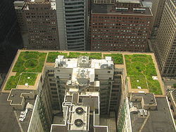
Not all cities have a distinct urban heat island. Mitigation of the urban heat island effect can be accomplished through the use of green roof
Green roof
A green roof is a roof of a building that is partially or completely covered with vegetation and a growing medium, planted over a waterproofing membrane. It may also include additional layers such as a root barrier and drainage and irrigation systems...
s and the use of lighter-colored surfaces in urban areas, which reflect more sunlight and absorb less heat. Recent qualitative speculations indicate that urban thermal plume
Urban thermal plume
An urban thermal plume describes rising air in the lower altitudes of the Earth's atmosphere caused by urban areas being warmer than surrounding areas. Over the past thirty years there has been increasing interest in what have been called urban heat island , but it is only since 2007 that thought...
s may contribute to variation in wind patterns that may influence the melting of arctic ice packs and thereby the cycle of ocean current.
Despite concerns raised about its possible contribution to global warming, comparisons between urban and rural areas show that the urban heat island effects have little influence on global mean temperature trends.
Causes
Thermal radiation
Thermal radiation is electromagnetic radiation generated by the thermal motion of charged particles in matter. All matter with a temperature greater than absolute zero emits thermal radiation....
into the relatively cold night sky. Two other reasons are changes in the thermal properties of surface materials and lack of evapotranspiration
Evapotranspiration
Evapotranspiration is a term used to describe the sum of evaporation and plant transpiration from the Earth's land surface to atmosphere. Evaporation accounts for the movement of water to the air from sources such as the soil, canopy interception, and waterbodies...
(for example through lack of vegetation) in urban areas. Materials commonly used in urban areas for pavement and roofs, such as concrete
Concrete
Concrete is a composite construction material, composed of cement and other cementitious materials such as fly ash and slag cement, aggregate , water and chemical admixtures.The word concrete comes from the Latin word...
and asphalt
Asphalt
Asphalt or , also known as bitumen, is a sticky, black and highly viscous liquid or semi-solid that is present in most crude petroleums and in some natural deposits, it is a substance classed as a pitch...
, have significantly different thermal bulk properties (including heat capacity and thermal conductivity
Thermal conductivity
In physics, thermal conductivity, k, is the property of a material's ability to conduct heat. It appears primarily in Fourier's Law for heat conduction....
) and surface radiative properties (albedo
Albedo
Albedo , or reflection coefficient, is the diffuse reflectivity or reflecting power of a surface. It is defined as the ratio of reflected radiation from the surface to incident radiation upon it...
and emissivity
Emissivity
The emissivity of a material is the relative ability of its surface to emit energy by radiation. It is the ratio of energy radiated by a particular material to energy radiated by a black body at the same temperature...
) than the surrounding rural areas. This causes a change in the energy balance
Energy balance
Energy balance may refer to:* First law of thermodynamics, according to which energy cannot be created or destroyed, only modified in form* Energy balance , a measurement of the biological homeostasis of energy in living systems...
of the urban area, often leading to higher temperatures than surrounding rural areas.
Other causes of a UHI are due to geometric effects. The tall buildings within many urban areas provide multiple surfaces for the reflection and absorption of sunlight, increasing the efficiency with which urban areas are heated. This is called the "urban canyon effect
Urban canyon
An urban canyon is an artefact of an urban environment similar to a natural canyon. It is manifested by streets cutting through dense blocks of structures, especially skyscrapers, which causes a canyon effect...
". Another effect of buildings is the blocking of wind, which also inhibits cooling by convection
Convection
Convection is the movement of molecules within fluids and rheids. It cannot take place in solids, since neither bulk current flows nor significant diffusion can take place in solids....
. Waste heat from automobiles, air conditioning, industry, and other sources also contributes to the UHI. High levels of pollution in urban areas can also increase the UHI, as many forms of pollution change the radiative properties of the atmosphere.
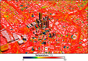
Some cities exhibit a heat island effect, largest at night. Seasonally, UHI shows up both in summer and winter. The typical temperature difference is several degrees between the center of the city and surrounding fields. The difference in temperature between an inner city and its surrounding suburbs is frequently mentioned in weather reports, as in "68 °F (20 °C) downtown, 64 °F (17.8 °C) in the suburbs". Black surfaces absorb significantly more electromagnetic radiation
Electromagnetic radiation
Electromagnetic radiation is a form of energy that exhibits wave-like behavior as it travels through space...
, and causes the surfaces of asphalt roads and highways to heat.
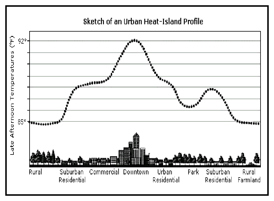
Diurnal behavior
The IPCCIntergovernmental Panel on Climate Change
The Intergovernmental Panel on Climate Change is a scientific intergovernmental body which provides comprehensive assessments of current scientific, technical and socio-economic information worldwide about the risk of climate change caused by human activity, its potential environmental and...
stated that "it is well-known that compared to non-urban areas urban heat islands raise night-time temperatures more than daytime temperatures." For example, Barcelona, Spain is 0.2 °C cooler for daily maxima and 2.9 °C warmer for minima than a nearby rural station. A description of the very first report of the UHI by Luke Howard
Luke Howard
Luke Howard FRS was a British manufacturing chemist and an amateur meteorologist with broad interests in science...
in the late 1810s said that the urban center of London was warmer at night than the surrounding countryside by 3.7 °F . Though the warmer air temperature within the UHI is generally most apparent at night, urban heat islands exhibit significant and somewhat paradoxical diurnal behavior. The air temperature difference between the UHI and the surrounding environment is large at night and small during the day. The opposite is true for skin temperatures of the urban landscape within the UHI.
Throughout the daytime, particularly when the skies are free of clouds, urban surfaces are warmed by the absorption of solar radiation. Surfaces in the urban areas tend to warm faster than those of the surrounding rural areas. By virtue of their high heat capacities
Heat capacity
Heat capacity , or thermal capacity, is the measurable physical quantity that characterizes the amount of heat required to change a substance's temperature by a given amount...
, urban surfaces act as a giant reservoir of heat energy. For example, concrete can hold roughly 2,000 times as much heat as an equivalent volume of air. As a result, the large daytime surface temperature within the UHI is easily seen via thermal remote sensing. As is often the case with daytime heating, this warming also has the effect of generating convective
Convection
Convection is the movement of molecules within fluids and rheids. It cannot take place in solids, since neither bulk current flows nor significant diffusion can take place in solids....
winds within the urban boundary layer
Boundary layer
In physics and fluid mechanics, a boundary layer is that layer of fluid in the immediate vicinity of a bounding surface where effects of viscosity of the fluid are considered in detail. In the Earth's atmosphere, the planetary boundary layer is the air layer near the ground affected by diurnal...
. It is theorized that, due to the atmospheric mixing that results, the air temperature perturbation within the UHI is generally minimal or nonexistent during the day, though the surface temperatures can reach extremely high levels.
At night, the situation reverses. The absence of solar heating causes the atmospheric convection to decrease, and the urban boundary layer begins to stabilize. If enough stabilization occurs, an inversion layer
Inversion (meteorology)
In meteorology, an inversion is a deviation from the normal change of an atmospheric property with altitude. It almost always refers to a temperature inversion, i.e...
is formed. This traps urban air near the surface, and keeping surface air warm from the still-warm urban surfaces, forming the nighttime warmer air temperatures within the UHI. Other than the heat retention properties of urban areas, the nighttime maximum in urban canyons could also be due to the blocking of "sky view" during cooling: surfaces lose heat at night principally by radiation to the comparatively cool sky, and this is blocked by the buildings in an urban area. Radiative cooling is more dominant when wind speed is low and the sky is cloudless, and indeed the UHI is found to be largest at night in these conditions.
Other impacts on weather and climate
Aside from the effect on temperature, UHIs can produce secondary effects on local meteorology, including the altering of local wind patterns, the development of cloudCloud
A cloud is a visible mass of liquid droplets or frozen crystals made of water and/or various chemicals suspended in the atmosphere above the surface of a planetary body. They are also known as aerosols. Clouds in Earth's atmosphere are studied in the cloud physics branch of meteorology...
s and fog
Fog
Fog is a collection of water droplets or ice crystals suspended in the air at or near the Earth's surface. While fog is a type of stratus cloud, the term "fog" is typically distinguished from the more generic term "cloud" in that fog is low-lying, and the moisture in the fog is often generated...
, the humidity
Humidity
Humidity is a term for the amount of water vapor in the air, and can refer to any one of several measurements of humidity. Formally, humid air is not "moist air" but a mixture of water vapor and other constituents of air, and humidity is defined in terms of the water content of this mixture,...
, and the rates of precipitation. The extra heat provided by the UHI leads to greater upward motion, which can induce additional shower and thunderstorm activity. In addition, the UHI creates during the day a local low pressure area where relatively moist air from its rural surroundings converges, possibly leading to more favorable conditions for cloud formation. Rainfall rates downwind of cities are increased between 48% and 116%. Partly as a result of this warming, monthly rainfall is about 28% greater between 20 miles (32.2 km) to 40 miles (64.4 km) downwind of cities, compared with upwind. Some cities show a total precipitation increase of 51%.
Research has been done in a few areas suggesting that metropolitan areas are less susceptible to weak tornadoes due to the turbulent mixing caused by the warmth of the urban heat island. Using satellite images, researchers discovered that city climates have a noticeable influence on plant growing seasons up to 10 kilometers (6 mi) away from a city's edges. Growing seasons in 70 cities in eastern North America were about 15 days longer in urban areas compared to rural areas outside of a city's influence.
Health effects
United States
The United States of America is a federal constitutional republic comprising fifty states and a federal district...
alone, an average of 1,000 people die each year due to extreme heat. As UHIs are characterized by increased temperature, they can potentially increase the magnitude and duration of heat wave
Heat wave
A heat wave is a prolonged period of excessively hot weather, which may be accompanied by high humidity. There is no universal definition of a heat wave; the term is relative to the usual weather in the area...
s within cities. Research has found that the mortality rate during a heat wave increases exponentially with the maximum temperature, an effect that is exacerbated by the UHI. The nighttime effect of UHIs can be particularly harmful during a heat wave, as it deprives urban residents of the cool relief found in rural areas during the night.
Research in the United States suggests that the relationship between extreme temperature and mortality varies by location. Heat is more likely to increase the risk of mortality in cities at mid-latitudes and high latitudes with significant annual temperature variation. For example, when Chicago
Chicago
Chicago is the largest city in the US state of Illinois. With nearly 2.7 million residents, it is the most populous city in the Midwestern United States and the third most populous in the US, after New York City and Los Angeles...
and New York
New York City
New York is the most populous city in the United States and the center of the New York Metropolitan Area, one of the most populous metropolitan areas in the world. New York exerts a significant impact upon global commerce, finance, media, art, fashion, research, technology, education, and...
experience unusually hot summertime temperatures, elevated levels of illness and death are predicted. In contrast, parts of the country that are mild to hot year-round have a lower public health risk from excessive heat. Research shows that residents of southern cities, such as Miami
Miami, Florida
Miami is a city located on the Atlantic coast in southeastern Florida and the county seat of Miami-Dade County, the most populous county in Florida and the eighth-most populous county in the United States with a population of 2,500,625...
, tend to be acclimated to hot weather conditions and therefore less vulnerable to heat related deaths.
Increased temperatures and sunny days help lead to the formation of low-level ozone from volatile organic compounds and nitrous oxides which already exist in the air. As urban heat islands lead to increased temperatures within cities, they contribute to worsened air quality. UHIs also impair water quality. Hot pavement and rooftop surfaces transfer their excess heat to stormwater, which then drains into storm sewers and raises water temperatures as it is released into streams, rivers, ponds, and lakes. Rapid temperature changes can be stressful to aquatic ecosystems.
Impact on nearby water bodies
Runoff from rainfall can lead to heating via conduction from the surface which the water is flowing over. In August 2001, rains over Cedar Rapids, IowaCedar Rapids, Iowa
Cedar Rapids is the second largest city in Iowa and is the county seat of Linn County. The city lies on both banks of the Cedar River, north of Iowa City and east of Des Moines, the state's capital and largest city...
led to a 10.5C (18.9F) rise in the nearby stream within one hour, which led to a fish kill. Since the temperature of the rain was comparatively cool, it could be attributed to the hot pavement of the city. Similar events have been documented across the American Midwest, as well as Oregon and California.
Impact on energy usage
Another consequence of urban heat islands is the increased energy required for air conditioningAir conditioning
An air conditioner is a home appliance, system, or mechanism designed to dehumidify and extract heat from an area. The cooling is done using a simple refrigeration cycle...
and refrigeration
Refrigeration
Refrigeration is a process in which work is done to move heat from one location to another. This work is traditionally done by mechanical work, but can also be done by magnetism, laser or other means...
in cities that are in comparatively hot climates. The Heat Island Group estimates that the heat island effect costs Los Angeles
Los Angeles, California
Los Angeles , with a population at the 2010 United States Census of 3,792,621, is the most populous city in California, USA and the second most populous in the United States, after New York City. It has an area of , and is located in Southern California...
about US$100 million per year in energy. Conversely, those that are in cold climates such as Moscow, Russia would have less demand for heating. However, through the implementation of heat island reduction strategies, significant annual net energy savings have been calculated for northern locations such as Chicago, Salt Lake City, and Toronto.
Mitigation
Albedo
Albedo , or reflection coefficient, is the diffuse reflectivity or reflecting power of a surface. It is defined as the ratio of reflected radiation from the surface to incident radiation upon it...
of the city. Relative to remedying the other sources of the problem, replacing dark roofing requires the least amount of investment for the most immediate return. A cool roof
Cool roof
Cool roofs are the roofs that can deliver high solar reflectance and high thermal emittance...
made from a reflective material such as vinyl can reflect three-quarters of the sun’s rays – usually far more – and emit 70 or more percent of the solar radiation absorbed by the building envelope. Asphalt built-up roofs (BUR), by comparison, reflect between 6 percent and 26 percent of solar radiation.
Using light-colored concrete has proven effective in reflecting up to 50% more light than asphalt and reducing ambient temperature. A low albedo value, characteristic of black asphalt, absorbs a large percentage of solar heat and contributes to the warming of cities. By paving with light colored concrete, in addition to replacing asphalt with light-colored concrete, communities can lower their average temperature. This is a long established practice in many countries.
A second option is to increase the amount of well-watered vegetation. These two options can be combined with the implementation of green roof
Green roof
A green roof is a roof of a building that is partially or completely covered with vegetation and a growing medium, planted over a waterproofing membrane. It may also include additional layers such as a root barrier and drainage and irrigation systems...
s. Green roofs are excellent insulators during the warm weather months and the plants cool the surrounding environment. Air quality is improved as the plants absorb and convert carbon dioxide to oxygen. The city of New York determined that the cooling potential per area was highest for street trees, followed by living roofs, light covered surface, and open space planting. From the standpoint of cost effectiveness, light surfaces, light roofs, and curbside planting have lower costs per temperature reduction.
A hypothetical "cool communities" program in Los Angeles
Los Ángeles
Los Ángeles is the capital of the province of Biobío, in the commune of the same name, in Region VIII , in the center-south of Chile. It is located between the Laja and Biobío rivers. The population is 123,445 inhabitants...
has projected that urban temperatures could be reduced by approximately 3 °C (5 °F) after planting ten million trees, reroofing five million homes, and painting one-quarter of the roads at an estimated cost of US$1 billion, giving estimated annual benefits of US$170 million from reduced air-conditioning costs and US$360 million in smog related health savings.
Green building programs
Voluntary green building programs have been promoting the mitigation of the heat island effect for years. For example, one of the ways for a site to earn points under the US Green Building Council’s (USGBC) Leadership in Energy and Environmental DesignLeadership in Energy and Environmental Design
Leadership in Energy and Environmental Design consists of a suite of rating systems for the design, construction and operation of high performance green buildings, homes and neighborhoods....
(LEED) Green Building Rating System is to take action that reduces heat islands, minimizing impacts on microclimates and human and wildlife habitats. Credits associated with reflective roofing or planted roofs can help a building achieve LEED certification. Buildings also receive credits by providing shade. Similarly, The Green Building Initiative (GBI)’s Green Globes
Green Globes
Green Globes is an environmental assessment, education and rating system that is promoted in the United States by the Green Building Initiative, a Portland, Oregon-based non-profit....
program awards points to sites that take measures to decrease a building’s energy consumption and reduce the heat island effect. As many as 10 points may be awarded to sites with roof coverage from vegetation, highly reflective materials, or a combination of the two.
Global warming
Urban sprawl
Urban sprawl, also known as suburban sprawl, is a multifaceted concept, which includes the spreading outwards of a city and its suburbs to its outskirts to low-density and auto-dependent development on rural land, high segregation of uses Urban sprawl, also known as suburban sprawl, is a...
might be misinterpreted as an increase in global temperature
Global warming
Global warming refers to the rising average temperature of Earth's atmosphere and oceans and its projected continuation. In the last 100 years, Earth's average surface temperature increased by about with about two thirds of the increase occurring over just the last three decades...
. While the "heat island" warming is an important local effect, there is no evidence that it biases trends in historical temperature record. For example, urban and rural trends are very similar.
The Third Assessment Report from the IPCC
IPCC Third Assessment Report
The IPCC Third Assessment Report, Climate Change 2001, is an assessment of available scientific and socio-economic information on climate change by the IPCC. The IPCC was established in 1988 by the United Nations Environment Programme and the UN's World Meteorological Organization ".....
says:
- However, over the Northern Hemisphere land areas where urban heat islands are most apparent, both the trends of lower-troposphericTroposphereThe troposphere is the lowest portion of Earth's atmosphere. It contains approximately 80% of the atmosphere's mass and 99% of its water vapor and aerosols....
temperature and surface air temperature show no significant differences. In fact, the lower-tropospheric temperatures warm at a slightly greater rate over North America (about 0.28°C/decade using satellite data) than do the surface temperatures (0.27°C/decade), although again the difference is not statistically significant.
Ground temperature measurements, like most weather observations, are logged by location. Their siting predates the massive sprawl, roadbuilding programs, and high- and medium-rise expansions which contribute to the UHI. More importantly, station logs allow sites in question to be filtered easily from data sets. Doing so, the presence of heat islands is visible, but overall trends change in magnitude, not direction.
The effects of the urban heat island may be overstated. One study stated, "Contrary to generally accepted wisdom, no statistically significant impact of urbanization could be found in annual temperatures." This was done by using satellite-based night-light detection of urban areas, and more thorough homogenisation of the time series (with corrections, for example, for the tendency of surrounding rural stations to be slightly higher in elevation, and thus cooler, than urban areas). If its conclusion is accepted, then it is necessary to "unravel the mystery of how a global temperature time series created partly from urban in situ stations could show no contamination from urban warming." The main conclusion is that microscale
Microscale meteorology
Microscale meteorology is the study of short-lived atmospheric phenomena smaller than mesoscale, about 1 km or less. These two branches of meteorology are sometimes grouped together as "mesoscale and microscale meteorology" and together study all phenomena smaller than synoptic scale; that is they...
and local-scale impacts dominate the mesoscale
Mesoscale meteorology
Mesoscale meteorology is the study of weather systems smaller than synoptic scale systems but larger than microscale and storm-scale cumulus systems. Horizontal dimensions generally range from around 5 kilometers to several hundred kilometers...
impact of the urban heat island. Many sections of towns may be warmer than rural sites, but surface weather observation
Surface weather observation
Surface weather observations are the fundamental data used for safety as well as climatological reasons to forecast weather and issue warnings worldwide. They can be taken manually, by a weather observer, by computer through the use of automated weather stations, or in a hybrid scheme using...
s are likely to be made in park "cool islands."
Not all cities show a warming relative to their rural surroundings. After trends were adjusted in urban weather station
Weather station
A weather station is a facility, either on land or sea, with instruments and equipment for observing atmospheric conditions to provide information for weather forecasts and to study the weather and climate. The measurements taken include temperature, barometric pressure, humidity, wind speed, wind...
s around the world to match rural stations in their regions, in an effort to homogenise the temperature record, in 42 percent of cases, cities were getting cooler relative to their surroundings rather than warmer. One reason is that urban areas are heterogeneous, and weather stations are often sited in "cool islands" – parks, for example – within urban areas.
Studies in 2004 and 2006 attempted to test the urban heat island theory, by comparing temperature readings taken on calm nights with those taken on windy nights. If the urban heat island theory is correct then instruments should have recorded a bigger temperature rise for calm nights than for windy ones, because wind blows excess heat away from cities and away from the measuring instruments. There was no difference between the calm and windy nights, and one study said that we show that, globally, temperatures over land have risen as much on windy nights as on calm nights, indicating that the observed overall warming is not a consequence of urban development.
A view often held by skeptics of global warming
Global warming
Global warming refers to the rising average temperature of Earth's atmosphere and oceans and its projected continuation. In the last 100 years, Earth's average surface temperature increased by about with about two thirds of the increase occurring over just the last three decades...
is that much of the temperature increase seen in land based thermometers could be due to an increase in urbanization and the siting of measurement stations in urban areas. For example, Ross McKitrick
Ross McKitrick
Ross McKitrick is a Canadian economist specializing in environmental economics and policy analysis. He is professor of economics at the University of Guelph; a senior fellow of the Fraser Institute, a Canadian free-market public policy think tank; and a member of the academic advisory boards of the...
and Patrick J. Michaels conducted a statistical study of surface-temperature data regressed
Regression analysis
In statistics, regression analysis includes many techniques for modeling and analyzing several variables, when the focus is on the relationship between a dependent variable and one or more independent variables...
against socioeconomic indicators, and concluded that about half of the observed warming trend (for 1979–2002) could be accounted for by the residual UHI effects in the corrected temperature data set they studied—which had already been processed to remove the (modeled) UHI contribution. Critics of this paper, including Gavin A. Schmidt, have said the results can be explained away as an artifact of spatial autocorrelation
Autocorrelation
Autocorrelation is the cross-correlation of a signal with itself. Informally, it is the similarity between observations as a function of the time separation between them...
. McKittrick and Nicolas Nierenberg stated further that "the evidence for contamination of climatic data is robust across numerous data sets."
The preliminary results of an independent assessment carried out by the Berkeley Earth Surface Temperature
Berkeley Earth Surface Temperature
The Berkeley Earth Surface Temperature project is an effort to resolve criticism of the current records of the Earth's surface temperatures by preparing an open database and analysis of these temperatures and temperature trends, to be available online, with all calculations, methods and results...
group, and made available to the public in October 2011, found that among other scientific concerns raised by skeptics, the urban heat island effect did not bias the results obtained by NOAA, the Hadley Centre and NASA's GISS. The Berkeley Earth group also confirmed that over the past 50 years the land surface warmed by 0.911°C, and their results closely matched those obtained from earlier studies.
Climate Change 2007, the Fourth Assessment Report from the IPCC
IPCC Fourth Assessment Report
Climate Change 2007, the Fourth Assessment Report of the United Nations Intergovernmental Panel on Climate Change , is the fourth in a series of reports intended to assess scientific, technical and socio-economic information concerning climate change, its potential effects, and options for...
states the following.
Studies that have looked at hemispheric and global scales conclude that any urban-related trend is an order of magnitude smaller than decadal and longer time-scale trends evident in the series (e.g., Jones et al., 1990; Peterson et al., 1999). This result could partly be attributed to the omission from the gridded data set of a small number of sites (<1%) with clear urban-related warming trends. In a worldwide set of about 270 stations, Parker (2004, 2006) noted that warming trends in night minimum temperatures over the period 1950 to 2000 were not enhanced on calm nights, which would be the time most likely to be affected by urban warming. Thus, the global land warming trend discussed is very unlikely to be influenced significantly by increasing urbanisation (Parker, 2006). ... Accordingly, this assessment adds the same level of urban warming uncertainty as in the TAR: 0.006°C per decade since 1900 for land, and 0.002°C per decade since 1900 for blended land with ocean, as ocean UHI is zero.
See also
- Anthropogenic heat
- Cool roofCool roofCool roofs are the roofs that can deliver high solar reflectance and high thermal emittance...
- David Parker (climatologist)David Parker (climatologist)David Parker is head of climate monitoring at the Hadley Centre.He has published extensively on the land and marine temperature record and its consistency...
- Urban climatologyUrban climatologyUrban Climatology refers to a specific branch of climatology, it is the branch of climatology concerned with the interactions between urban areas and the atmosphere; the impacts they have on one another; and examines these processes at various scales see also: urban climate- History :Luke Howard...
- Urban dust domeUrban dust domeUrban dust domes are a meteorological phenomena in which soot, dust, and chemical emissions become trapped in the air above urban spaces. This trapping is a product of local air circulations. Calm surface winds are drawn to urban centers, they then rise above the city and descend slowly on the...
- Urban thermal plumeUrban thermal plumeAn urban thermal plume describes rising air in the lower altitudes of the Earth's atmosphere caused by urban areas being warmer than surrounding areas. Over the past thirty years there has been increasing interest in what have been called urban heat island , but it is only since 2007 that thought...
External links
- Land-Surface Air Temperature - from the IPCCIntergovernmental Panel on Climate ChangeThe Intergovernmental Panel on Climate Change is a scientific intergovernmental body which provides comprehensive assessments of current scientific, technical and socio-economic information worldwide about the risk of climate change caused by human activity, its potential environmental and...
- Lawrence Berkeley National Laboratory Heat Island Group
- NASA Earth Observatory: The Earth's Big Cities, Urban Heat Islands
- Urban Heat Islands and Climate Change - from the University of Melbourne, Australia
- Research and mitigation strategies on UHI - US EPA designated, National Center of Excellence on SMART Innovations at Arizona State University
- The Surface Temperature Record and the Urban Heat Island From RealClimate.org
- Urban Heat Island research group - NSF project, Department of Geography, Indiana State University
- UrbanHeatIslands.com - Urban Heat islands in Canada and the world