
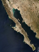
Baja California Peninsula
Encyclopedia
_250m.jpg)
Peninsula
A peninsula is a piece of land that is bordered by water on three sides but connected to mainland. In many Germanic and Celtic languages and also in Baltic, Slavic and Hungarian, peninsulas are called "half-islands"....
in northwestern Mexico
Mexico
The United Mexican States , commonly known as Mexico , is a federal constitutional republic in North America. It is bordered on the north by the United States; on the south and west by the Pacific Ocean; on the southeast by Guatemala, Belize, and the Caribbean Sea; and on the east by the Gulf of...
. Its land mass separates the Pacific Ocean
Pacific Ocean
The Pacific Ocean is the largest of the Earth's oceanic divisions. It extends from the Arctic in the north to the Southern Ocean in the south, bounded by Asia and Australia in the west, and the Americas in the east.At 165.2 million square kilometres in area, this largest division of the World...
from the Gulf of California
Gulf of California
The Gulf of California is a body of water that separates the Baja California Peninsula from the Mexican mainland...
. The Peninsula extends 1247 kilometres (774.9 mi) from Mexicali
Mexicali
Mexicali is the capital of the State of Baja California, seat of the Municipality of Mexicali, and 2nd largest city in Baja California. The City of Mexicali has a population of 689,775, according to the 2010 census, while the population of the entire metropolitan area reaches 936,826.The city...
, Baja California
Baja California
Baja California officially Estado Libre y Soberano de Baja California is one of the 31 states which, with the Federal District, comprise the 32 Federal Entities of Mexico. It is both the northernmost and westernmost state of Mexico. Before becoming a state in 1953, the area was known as the North...
in the north to Cabo San Lucas
Cabo San Lucas
Cabo San Lucas , commonly called Cabo, is a city at the southern tip of the Baja California peninsula, in the municipality of Los Cabos in the Mexican state of Baja California Sur. As of the 2010 census, the population was 68,463 people...
, Baja California Sur
Baja California Sur
Baja California Sur , is one of the 31 states which, with the Federal District, comprise the 32 Federal Entities of Mexico. Before becoming a state on October 8, 1974, the area was known as the South Territory of Baja California. It has an area of , or 3.57% of the land mass of Mexico and comprises...
in the south.
The total area of the Baja California Peninsula is 143390 sqkm. The Peninsula is separated from mainland Mexico
Mexico
The United Mexican States , commonly known as Mexico , is a federal constitutional republic in North America. It is bordered on the north by the United States; on the south and west by the Pacific Ocean; on the southeast by Guatemala, Belize, and the Caribbean Sea; and on the east by the Gulf of...
by the Gulf of California
Gulf of California
The Gulf of California is a body of water that separates the Baja California Peninsula from the Mexican mainland...
and the Colorado River
Colorado River
The Colorado River , is a river in the Southwestern United States and northwestern Mexico, approximately long, draining a part of the arid regions on the western slope of the Rocky Mountains. The watershed of the Colorado River covers in parts of seven U.S. states and two Mexican states...
, though on the Colorado there are bridges to the state of Sonora
Sonora
Sonora officially Estado Libre y Soberano de Sonora is one of the 31 states which, with the Federal District, comprise the 32 Federal Entities of Mexico. It is divided into 72 municipalities; the capital city is Hermosillo....
. There are four main desert areas on the peninsula: the San Felipe Desert, the Central Coast Desert, the Vizcaíno Desert and the Magdalena Plain Desert.
History
In the minds of European explorers California existed as an idea before it was discovered. The earliest known mention of the idea of California was in the 1510 romance novel Las Sergas de Esplandián by Spanish author Garci Rodríguez de MontalvoGarci Rodríguez de Montalvo
Garci Rodríguez de Montalvo was a Spanish author who arranged the modern version of the chivalric romance Amadis of Gaul, written in three books in the 14th century by an unknown author...
. The book described the Island of California
Island of California
The Island of California refers to a long-held European misconception, dating from the 16th century, that California was not part of mainland North America but rather a large island separated from the continent by a strait now known instead as the Gulf of California.One of the most famous...
as being west of the Indies, "very close to the side of the Terrestrial Paradise; and it is peopled by black women, without any man among them, for they live in the manner of Amazons
Amazons
The Amazons are a nation of all-female warriors in Greek mythology and Classical antiquity. Herodotus placed them in a region bordering Scythia in Sarmatia...
."
Following Hernán Cortés
Hernán Cortés
Hernán Cortés de Monroy y Pizarro, 1st Marquis of the Valley of Oaxaca was a Spanish Conquistador who led an expedition that caused the fall of the Aztec Empire and brought large portions of mainland Mexico under the rule of the King of Castile in the early 16th century...
's conquest of Mexico, the lure of an earthly paradise as well as the search for the fabled Strait of Anián, helped motivate him to send several expeditions to the west coast of New Spain in the 1530s and early 1540s. Its first expedition reached the Gulf of California and California, and proved the Island of California was in fact a peninsula. Nevertheless, the idea of the island persisted for well over a century and was included in many maps. The Spaniards gave the name "California" to the peninsula and to the lands north, including both Baja California and Alta California
Alta California
Alta California was a province and territory in the Viceroyalty of New Spain and later a territory and department in independent Mexico. The territory was created in 1769 out of the northern part of the former province of Las Californias, and consisted of the modern American states of California,...
, the region that became parts of the present-day U.S. states of California
California
California is a state located on the West Coast of the United States. It is by far the most populous U.S. state, and the third-largest by land area...
, Nevada
Nevada
Nevada is a state in the western, mountain west, and southwestern regions of the United States. With an area of and a population of about 2.7 million, it is the 7th-largest and 35th-most populous state. Over two-thirds of Nevada's people live in the Las Vegas metropolitan area, which contains its...
, Utah
Utah
Utah is a state in the Western United States. It was the 45th state to join the Union, on January 4, 1896. Approximately 80% of Utah's 2,763,885 people live along the Wasatch Front, centering on Salt Lake City. This leaves vast expanses of the state nearly uninhabited, making the population the...
, Arizona
Arizona
Arizona ; is a state located in the southwestern region of the United States. It is also part of the western United States and the mountain west. The capital and largest city is Phoenix...
, and parts of Colorado
Colorado
Colorado is a U.S. state that encompasses much of the Rocky Mountains as well as the northeastern portion of the Colorado Plateau and the western edge of the Great Plains...
and Wyoming
Wyoming
Wyoming is a state in the mountain region of the Western United States. The western two thirds of the state is covered mostly with the mountain ranges and rangelands in the foothills of the Eastern Rocky Mountains, while the eastern third of the state is high elevation prairie known as the High...
.
Partition
Las Californias
The Californias, or in — - was the name given by the Spanish to their northwestern territory of New Spain, comprising the present day states of Baja California and Baja California Sur on the Baja California Peninsula in Mexico; and the present day U.S. state of California in the United States of...
was divided into Alta California
Alta California
Alta California was a province and territory in the Viceroyalty of New Spain and later a territory and department in independent Mexico. The territory was created in 1769 out of the northern part of the former province of Las Californias, and consisted of the modern American states of California,...
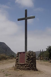
and Baja California on May 19, 1773 near San Juan Bautista Creek by Fray Francisco Palóu
Francisco Palóu
Francesc Palou was a Franciscan missionary, administrator, and historian on the Baja California peninsula and in Alta California. Father Palou's made significant contributions to the Alta California and Baja California mission systems...
. A marker is erected in the place where the dividing committee began the measurements for the province's partition. The marker is behind the Misión San Miguel Arcángel de la Frontera
Misión San Miguel Arcángel de la Frontera
Mission San Miguel was established on 28 March 1787 by the Dominican missionary Luis Sales among the Kumeyaay Indians of northwestern Baja California, Mexico...
, near Ensenada, Baja California
Ensenada, Baja California
Ensenada is a coastal city in Mexico and the third-largest city in Baja California. It is located south of San Diego on the Baja California Peninsula. The city is locally referred to as La Cenicienta del Pacífico, or, The Cinderella of the Pacific...
.
Translated into English
English language
English is a West Germanic language that arose in the Anglo-Saxon kingdoms of England and spread into what was to become south-east Scotland under the influence of the Anglian medieval kingdom of Northumbria...
, the inscription on the marker reads:
San Juan Bautista Creek: Juan CrespíJuan CrespiFather Juan Crespí was a Majorcan missionary and explorer of Las Californias. He entered the Franciscan order at the age of seventeen. He came to America in 1749, and accompanied explorers Francisco Palóu and Junípero Serra. In 1767 he went to the Baja Peninsula and was placed in charge of the...
, May 1 for the setting of the first international division line between Old or Lower California (DominicansDominican OrderThe Order of Preachers , after the 15th century more commonly known as the Dominican Order or Dominicans, is a Catholic religious order founded by Saint Dominic and approved by Pope Honorius III on 22 December 1216 in France...
) and New or Upper California (FranciscanFranciscanMost Franciscans are members of Roman Catholic religious orders founded by Saint Francis of Assisi. Besides Roman Catholic communities, there are also Old Catholic, Anglican, Lutheran, ecumenical and Non-denominational Franciscan communities....
s) five leagues to the north (Valley of the Médanos) being established by: Priest Francisco PalóuFrancisco PalóuFrancesc Palou was a Franciscan missionary, administrator, and historian on the Baja California peninsula and in Alta California. Father Palou's made significant contributions to the Alta California and Baja California mission systems...
on 19 August 1773 (Mojonera of Palou) in compliance with the instructions put forth on the April 7, 1772 ConcordatConcordatA concordat is an agreement between the Holy See of the Catholic Church and a sovereign state on religious matters. Legally, they are international treaties. They often includes both recognition and privileges for the Catholic Church in a particular country...
o.
Rosarito Historical Society, Baja California A.C. at The Mission, Baja California, on 20 May 1990. Fieldwork and research: . Monument donation: Mario Reyes Coronado De Villasari & family . Construction: Students of the School of Tourism at U.A.B.C.(Autonomous University of Baja California).
Territory
The whole peninsula of Baja California was: the lower part of the Las CaliforniasLas Californias
The Californias, or in — - was the name given by the Spanish to their northwestern territory of New Spain, comprising the present day states of Baja California and Baja California Sur on the Baja California Peninsula in Mexico; and the present day U.S. state of California in the United States of...
Province of the Spanish Viceroyalty of New Spain; and then a single territory of Mexico from 1773 until 1931, when it was divided into Northern and Southern territories. In 1952, the "North Territory of Baja California" became the 29th State of Mexico
States of Mexico
The United Mexican States is a federal republic formed by 32 federal entities .According to the Constitution of 1917, the states of the federation are free and sovereign. Each state has their own congress and constitution, while the Federal District has only limited autonomy with a local Congress...
as Baja California
Baja California
Baja California officially Estado Libre y Soberano de Baja California is one of the 31 states which, with the Federal District, comprise the 32 Federal Entities of Mexico. It is both the northernmost and westernmost state of Mexico. Before becoming a state in 1953, the area was known as the North...
, and in 1974, the "South Territory of Baja California" became the 31st state as Baja California Sur
Baja California Sur
Baja California Sur , is one of the 31 states which, with the Federal District, comprise the 32 Federal Entities of Mexico. Before becoming a state on October 8, 1974, the area was known as the South Territory of Baja California. It has an area of , or 3.57% of the land mass of Mexico and comprises...
.
Timeline
- 1532: Hernán CortésHernán CortésHernán Cortés de Monroy y Pizarro, 1st Marquis of the Valley of Oaxaca was a Spanish Conquistador who led an expedition that caused the fall of the Aztec Empire and brought large portions of mainland Mexico under the rule of the King of Castile in the early 16th century...
sends three ships north along the coast of MexicoMexicoThe United Mexican States , commonly known as Mexico , is a federal constitutional republic in North America. It is bordered on the north by the United States; on the south and west by the Pacific Ocean; on the southeast by Guatemala, Belize, and the Caribbean Sea; and on the east by the Gulf of...
in search of the Island of CaliforniaIsland of CaliforniaThe Island of California refers to a long-held European misconception, dating from the 16th century, that California was not part of mainland North America but rather a large island separated from the continent by a strait now known instead as the Gulf of California.One of the most famous...
. The three ships disappear without a trace. - 1533: Cortés sends a follow-up mission to search for the lost ships. Pilot Fortún XiménezFortún XiménezFortún Ximénez was Spanish sailor who led a mutiny during an early expedition along the coast of Mexico and is the first European known to have landed in Baja California....
leads a mutiny and founds a settlement in the Bay of La Paz before being killed. - 1539: Francisco de UlloaFrancisco de UlloaFrancisco de Ulloa was a Spanish explorer who explored the west coast of present-day Mexico under the commission of Hernán Cortés...
explores both coasts. - 1690s– first decade of the 18th century: Spanish settlement and colonization in lower Las Californias (Baja peninsula), the Spanish missions in Baja CaliforniaSpanish missions in Baja CaliforniaThe Spanish Missions in Baja California comprise a series of religious outposts established by Spanish Catholic religious orders, the Jesuits, the Franciscans and the Dominicans, between 1683 and 1834 to spread the Christian doctrine among the local natives...
established. - 1773: The Spanish province of Las CaliforniasLas CaliforniasThe Californias, or in — - was the name given by the Spanish to their northwestern territory of New Spain, comprising the present day states of Baja California and Baja California Sur on the Baja California Peninsula in Mexico; and the present day U.S. state of California in the United States of...
is divided into Alta ("Upper") and Baja ("Lower") California. - 1810-1821: Mexican War of IndependenceMexican War of IndependenceThe Mexican War of Independence was an armed conflict between the people of Mexico and the Spanish colonial authorities which started on 16 September 1810. The movement, which became known as the Mexican War of Independence, was led by Mexican-born Spaniards, Mestizos and Amerindians who sought...
- 1821: First Mexican EmpireFirst Mexican EmpireThe Mexican Empire was the official name of independent Mexico under a monarchical regime from 1821 to 1823. The territory of the Mexican Empire included the continental intendencies and provinces of New Spain proper...
, Baja California peninsula becomes a Mexican territory. - 1847: The Battle of La PazBattle of La PazThe Battle of La Paz was an engagement of the Pacific Coast Campaign during the Mexican-American War. The belligerents were United States Army troops against Mexican militia, commanded by Mexican Army officers...
and the Siege of La PazSiege of La PazThe Siege of La Paz was a Mexican siege of their own city of La Paz in Baja California Sur. Mexican militia forces attempted to destroy the United States Army garrison, occupying the peninsular town...
occurs, as well as several other engagementsBattle of San José del CaboThe Battle of San José del Cabo was a military engagement of the Mexican-American War which took place on two November days in 1847, after the fall of Mexico City.-Background:...
. - 1848: Treaty of Guadalupe HidalgoTreaty of Guadalupe HidalgoThe Treaty of Guadalupe Hidalgo is the peace treaty, largely dictated by the United States to the interim government of a militarily occupied Mexico City, that ended the Mexican-American War on February 2, 1848...
cedes Alta CaliforniaAlta CaliforniaAlta California was a province and territory in the Viceroyalty of New Spain and later a territory and department in independent Mexico. The territory was created in 1769 out of the northern part of the former province of Las Californias, and consisted of the modern American states of California,...
to the United StatesUnited StatesThe United States of America is a federal constitutional republic comprising fifty states and a federal district...
. As a U.S. territory it receives the California Gold RushCalifornia Gold RushThe California Gold Rush began on January 24, 1848, when gold was found by James W. Marshall at Sutter's Mill in Coloma, California. The first to hear confirmed information of the gold rush were the people in Oregon, the Sandwich Islands , and Latin America, who were the first to start flocking to...
, causing increased maritime traffic along the peninsula. - 1850: CaliforniaCaliforniaCalifornia is a state located on the West Coast of the United States. It is by far the most populous U.S. state, and the third-largest by land area...
admitted to U.S. statehood. - 1853: William Walker, with 45 men, captures the capital city of La PazLa Paz, Baja California SurLa Paz is the capital city of the Mexican state of Baja California Sur and an important regional commercial center. The city had a 2010 census population of 215,178 persons, but its metropolitan population is somewhat larger because of surrounding towns like el Centenario, el Zacatal and San Pedro...
and declares himself President of the Republic of Lower California. Mexico forces him to retreat a few months later. - 1930-31: The Territory of Baja California is further divided into Northern and Southern territories (North Territory of Baja California & South Territory of Baja California).
- 1952: The North Territory of Baja California becomes the 29th State of MexicoStates of MexicoThe United Mexican States is a federal republic formed by 32 federal entities .According to the Constitution of 1917, the states of the federation are free and sovereign. Each state has their own congress and constitution, while the Federal District has only limited autonomy with a local Congress...
, Baja CaliforniaBaja CaliforniaBaja California officially Estado Libre y Soberano de Baja California is one of the 31 states which, with the Federal District, comprise the 32 Federal Entities of Mexico. It is both the northernmost and westernmost state of Mexico. Before becoming a state in 1953, the area was known as the North...
. The southern portion, below 28°N, remains a federally administered territory. - 1973: The 1700 km (1,056.3 mi) long Trans-Peninsular Highway (Mexican Federal Highway 1Mexican Federal Highway 1Mexican Federal Highway No. 1 follows the length of the Baja California Peninsula from Cabo San Lucas , at the southern end to Tijuana in the north...
), is finished. It is the first paved road that spans the entire peninsula. The highway was built by the Mexican government to improve Baja's economy and increase tourism. - 1974: The South Territory of Baja California becomes the 31st state, Baja California SurBaja California SurBaja California Sur , is one of the 31 states which, with the Federal District, comprise the 32 Federal Entities of Mexico. Before becoming a state on October 8, 1974, the area was known as the South Territory of Baja California. It has an area of , or 3.57% of the land mass of Mexico and comprises...
. - 1989: Baja CaliforniaBaja CaliforniaBaja California officially Estado Libre y Soberano de Baja California is one of the 31 states which, with the Federal District, comprise the 32 Federal Entities of Mexico. It is both the northernmost and westernmost state of Mexico. Before becoming a state in 1953, the area was known as the North...
elects Ernesto Ruffo AppelErnesto Ruffo AppelErnesto Ruffo Appel is an American-born Mexican politician famous for being the first state governor not belonging to the Partido Revolucionario Institucional since its formation in 1929....
the first non PRIInstitutional Revolutionary PartyThe Institutional Revolutionary Party is a Mexican political party that held power in the country—under a succession of names—for more than 70 years. The PRI is a member of the Socialist International, as is the rival Party of the Democratic Revolution , making Mexico one of the few...
governor since 1929.
Baja California
The northern part is the StateStates of Mexico
The United Mexican States is a federal republic formed by 32 federal entities .According to the Constitution of 1917, the states of the federation are free and sovereign. Each state has their own congress and constitution, while the Federal District has only limited autonomy with a local Congress...
of Baja California
Baja California
Baja California officially Estado Libre y Soberano de Baja California is one of the 31 states which, with the Federal District, comprise the 32 Federal Entities of Mexico. It is both the northernmost and westernmost state of Mexico. Before becoming a state in 1953, the area was known as the North...
. The citizens of Baja California are named Baja-Californiano (Lower-Californian in English).
- MexicaliMexicaliMexicali is the capital of the State of Baja California, seat of the Municipality of Mexicali, and 2nd largest city in Baja California. The City of Mexicali has a population of 689,775, according to the 2010 census, while the population of the entire metropolitan area reaches 936,826.The city...
is the capital of the state of Baja CaliforniaBaja CaliforniaBaja California officially Estado Libre y Soberano de Baja California is one of the 31 states which, with the Federal District, comprise the 32 Federal Entities of Mexico. It is both the northernmost and westernmost state of Mexico. Before becoming a state in 1953, the area was known as the North...
.
Baja California Sur
The southern part, below 28° north, is the StateStates of Mexico
The United Mexican States is a federal republic formed by 32 federal entities .According to the Constitution of 1917, the states of the federation are free and sovereign. Each state has their own congress and constitution, while the Federal District has only limited autonomy with a local Congress...
of Baja California Sur
Baja California Sur
Baja California Sur , is one of the 31 states which, with the Federal District, comprise the 32 Federal Entities of Mexico. Before becoming a state on October 8, 1974, the area was known as the South Territory of Baja California. It has an area of , or 3.57% of the land mass of Mexico and comprises...
. The citizens of Baja California Sur are named Sud-Californianos ( "South-Californian" in English ).
- La PazLa Paz, Baja California SurLa Paz is the capital city of the Mexican state of Baja California Sur and an important regional commercial center. The city had a 2010 census population of 215,178 persons, but its metropolitan population is somewhat larger because of surrounding towns like el Centenario, el Zacatal and San Pedro...
is the capital of the state of Baja California SurBaja California SurBaja California Sur , is one of the 31 states which, with the Federal District, comprise the 32 Federal Entities of Mexico. Before becoming a state on October 8, 1974, the area was known as the South Territory of Baja California. It has an area of , or 3.57% of the land mass of Mexico and comprises...
.
Geology
The Baja California peninsula was once a part of the North American PlateNorth American Plate
The North American Plate is a tectonic plate covering most of North America, Greenland, Cuba, Bahamas, and parts of Siberia, Japan and Iceland. It extends eastward to the Mid-Atlantic Ridge and westward to the Chersky Range in eastern Siberia. The plate includes both continental and oceanic crust...
, the tectonic plate of which mainland Mexico remains a part. About 12 to 15 million years ago the East Pacific Rise
East Pacific Rise
The East Pacific Rise is a mid-oceanic ridge, a divergent tectonic plate boundary located along the floor of the Pacific Ocean. It separates the Pacific Plate to the west from the North American Plate, the Rivera Plate, the Cocos Plate, the Nazca Plate, and the Antarctic Plate...
began cutting into the margin of the North American Plate, initiating the separation of the peninsula from it. Spreading within the Gulf of California consists of short oblique rifts or ridge segments connected by long northwest trending transform fault
Transform fault
A transform fault or transform boundary, also known as conservative plate boundary since these faults neither create nor destroy lithosphere, is a type of fault whose relative motion is predominantly horizontal in either sinistral or dextral direction. Furthermore, transform faults end abruptly...
s, which together comprise the Gulf of California Rift Zone
Gulf of California Rift Zone
The Gulf of California Rift Zone is the northernmost extension of the East Pacific Rise which extends some 1300 km from the mouth of the Gulf of California to the southern terminus of the San Andreas Fault at the Salton Sink....
. The north end of the rift zone is located in the Brawley seismic zone
Brawley seismic zone
The Brawley Seismic Zone , also known as the Brawley fault zone, is a predominantly extensional tectonic zone that connects the southern terminus of the San Andreas Fault with the Imperial Fault in Southern California...
in the Salton Sea
Salton Sea
The Salton Sea is a shallow, saline, endorheic rift lake located directly on the San Andreas Fault, predominantly in California's Imperial Valley. The lake occupies the lowest elevations of the Salton Sink in the Colorado Desert of Imperial and Riverside counties in Southern California. Like Death...
basin between the Cerro Prieto Fault
Cerro Prieto Fault
The Cerro Prieto Fault is a transform fault located in far northern Baja California. It runs between the Cerro Prieto spreading center located southwest of Mexicali, and the Wagner Basin, another spreading center which lies under the Gulf of California...
and the San Andreas Fault
San Andreas Fault
The San Andreas Fault is a continental strike-slip fault that runs a length of roughly through California in the United States. The fault's motion is right-lateral strike-slip...
. The Baja California peninsula is now part of the Pacific Plate
Pacific Plate
The Pacific Plate is an oceanic tectonic plate that lies beneath the Pacific Ocean. At 103 million square kilometres, it is the largest tectonic plate....
and is moving with it away from the East Pacific Rise in a north northwestward direction.
Along the coast north of Santa Rosalia, Baja California Sur
Santa Rosalía, Baja California Sur
Santa Rosalía is a city located on the Baja California peninsula, in the northern part of the Mexican state of Baja California Sur. It was named after Saint Rosalia, although the reason for the name is not quite clear since the Misión de Santa Rosalía is not located by the town, but rather in...
is a prominent volcanic activity area
Volcanoes of east-central Baja California
The Volcanoes of east-central Baja California are located on the Baja California Peninsula near the Gulf of California, in the state of Baja California Sur, in Mexico.-La Reforma Caldera:...
.
Volcanoes of the peninsula and adjacent islands include:
- Volcanoes of east-central Baja CaliforniaVolcanoes of east-central Baja CaliforniaThe Volcanoes of east-central Baja California are located on the Baja California Peninsula near the Gulf of California, in the state of Baja California Sur, in Mexico.-La Reforma Caldera:...
- and
- Cerro PrietoCerro PrietoCerro Prieto is a small rural town located in the county of La Misión in the northwestern part of the Mexican state of Hidalgo....
- The San Quintín Volcanic Field
- Isla San Luis
- Jaraguay Volcanic Field
- CoronadoCoronado (volcano)Coronado is a volcano on Isla Coronado, in the state of Baja California, Mexico.Located in the Bahia de los Angeles , Isla Coronado is just off the eastern shoreline of Mexico’s Baja California Peninsula, in the Gulf of California...
- GuadalupeGuadalupe IslandGuadalupe Island, or Isla Guadalupe is a volcanic island located 241 kilometers off the west coast of Mexico's Baja California peninsula and some 400 kilometers southwest of the city of Ensenada in Baja California state, in the Pacific Ocean...
- San Borja Volcanic Field
- El Aguajito
- Tres VírgenesTres VirgenesTres Virgenes is a complex of volcanoes located Mulegé Municipality in the state of Baja California Sur, on the Baja California Peninsula in northwestern Mexico...
- Isla TortugaIsla TortugaIsla Tortuga is an island in the Gulf of California, created relatively recently in geologic terms by the volcanism associated with the East Pacific Rise. It lies east-northeast of the city of Santa Rosalía, in Mulegé Municipality. It has a surface area of 11.374 km² .-References:*...
- Comondú-La Purísima
- Cerro Prieto
Geographic features
- See also: Natural history of Baja California Sur and Category: Geography of Baja California
The Peninsular Ranges
Peninsular Ranges
The Peninsular Ranges are a group of mountain ranges, in the Pacific Coast Ranges, which stretch from southern California in the United States to the southern tip of Mexico's Baja California peninsula; they are part of the North American Coast Ranges that run along the Pacific coast from Alaska...
form the backbone of the peninsula. They are an uplifted and eroded Jurassic
Jurassic
The Jurassic is a geologic period and system that extends from about Mya to Mya, that is, from the end of the Triassic to the beginning of the Cretaceous. The Jurassic constitutes the middle period of the Mesozoic era, also known as the age of reptiles. The start of the period is marked by...
to Cretaceous
Cretaceous
The Cretaceous , derived from the Latin "creta" , usually abbreviated K for its German translation Kreide , is a geologic period and system from circa to million years ago. In the geologic timescale, the Cretaceous follows the Jurassic period and is followed by the Paleogene period of the...
batholith
Batholith
A batholith is a large emplacement of igneous intrusive rock that forms from cooled magma deep in the Earth's crust...
, part of the same original batholith chain which formed much of the Sierra Nevada
Sierra Nevada (US)
The Sierra Nevada is a mountain range in the U.S. states of California and Nevada, between the California Central Valley and the Basin and Range Province. The Sierra runs north-to-south, and is approximately across east-to-west...
mountains in U.S. California. This chain was formed primarily as a result of the subduction of the Farallon Plate
Farallon Plate
The Farallon Plate was an ancient oceanic plate, which began subducting under the west coast of the North American Plate— then located in modern Utah— as Pangaea broke apart during the Jurassic Period...
millions of years ago all along the margin of North America
North America
North America is a continent wholly within the Northern Hemisphere and almost wholly within the Western Hemisphere. It is also considered a northern subcontinent of the Americas...
.
- The Sierra JuárezSierra JuárezSierra de Juárez is a mountain range on the Baja California Peninsula, of Baja California, Mexico. It is part of the Peninsular Ranges. The Laguna Mountains of California lie to the north and the Sierra San Pedro Mártir lies to the south....
is the northernmost range in Mexico. - The Sierra San Pedro MártirSierra San Pedro MártirSierra de San Pedro Mártir is a mountain range that is one of the Peninsular Ranges of the Baja California peninsula, Mexico. At , the highest peak is the Picacho del Diablo, also known as Cerro de la Encantada or Picacho la Providencia...
runs south of the Sierra Juarez and includes the peninsula's highest peak, the Picacho del DiabloPicacho del DiabloPicacho del Diablo is the highest peak in Baja California, measuring . It is alternately called Cerro de la Encantada, "Hill of the Enchanted." The peak is located in the Sierra San Pedro Martir in the Mexican state of Baja California Norte....
. - The Sierra de San Borja runs south of the Sierra San Pedro Martir.
- The volcanic complex of Tres VirgenesTres VirgenesTres Virgenes is a complex of volcanoes located Mulegé Municipality in the state of Baja California Sur, on the Baja California Peninsula in northwestern Mexico...
lies in Baja California Sur, near the border with the state of Baja California, forming the ranges south of the Sierra de San Borja. - The Sierra de la GigantaSierra de la GigantaThe Sierra de la Giganta is a mountain range of Baja California Sur state in northwestern Mexico. The range extends parallel to the coast of the Gulf of California, west of the town of Loreto. The Sierra de la Giganta is one of the landforms in the Peninsular Ranges, which extend from Southern...
runs along the shore of the Gulf of California south of the Tres Virgenes complex. - At the south end of Baja California Sur, the Sierra de la LagunaSierra de la LagunaThe Sierra de la Laguna is a mountain range on the Baja California Peninsula of Mexico. It lies at the southern end of the peninsula in the state of Baja California Sur, and is the southernmost range of the Peninsular Ranges....
forms an isolated mountain range rising to 2406 m. - Another isolated range, the Sierra Vizcaino, juts out into the Pacific between Punta Eugenia and Punta Abreojos.
The two most prominent capes along the Pacific coastline of the peninsula are Punta Eugenia, located about halfway up the coast, and Cabo San Lazaro, located about a quarter of the way north from Cabo San Lucas.
The Bahia Sebastian Vizcaino, the largest bay in Baja, lies along the Pacific coast halfway up the peninsula. The large island of Isla Cedros is situated between the bay and the Pacific, just north of Punta Eugenia. Onshore southeast of the bay is the Desierto de Vizcaino, an extensive desert lying between the Sierra Vizcaino to the west, and the Tres Virgenes range which runs along the Gulf of California to the east.
The largest bays along the coastline of the Gulf are Bahia de La Paz where the city of La Paz is located, and Bahia Concepcion. The Bahía de los Ángeles
Bahía de los Ángeles
' is a coastal bay on the Sea of Cortez, located along the eastern shore of the Baja California Peninsula in the state of Baja California, Mexico...
is a small bay
Headlands and bays
Headlands and bays are two related features of the coastal environment.- Geology and geography :Headlands and bays are often found on the same coastline. A bay is surrounded by land on three sides, whereas a headland is surrounded by water on three sides. Headlands are characterized by high,...
located west of the Canal de las Ballenas which separates the Baja peninsula from the large island of Angel de la Guarda in the Gulf of California.
Ecoregions
- See also: Category: Flora of Baja California; Category: Flora of Baja California Sur; and Category: Flora of Gulf of California islands
The peninsula is home to several distinct ecoregion
Ecoregion
An ecoregion , sometimes called a bioregion, is an ecologically and geographically defined area that is smaller than an ecozone and larger than an ecosystem. Ecoregions cover relatively large areas of land or water, and contain characteristic, geographically distinct assemblages of natural...
s. Most of the peninsula is deserts and xeric shrublands
Deserts and xeric shrublands
Deserts and xeric shrublands is a biome characterized by, relating to, or requiring only a small amount of moisture.-Definition and occurrence:...
, although pine-oak forests are found in the mountains at the northern and southern ends of the peninsula. The southern tip of the peninsula, which was formerly an island, has many species with affinities to tropical Mexico.
- California chaparral and woodlandsCalifornia chaparral and woodlandsThe California chaparral and woodlands is a terrestrial ecoregion of lower northern, central, and southern California and northwestern Baja California , located on the west coast of North America...
, which covers the Mediterranean climateMediterranean climateA Mediterranean climate is the climate typical of most of the lands in the Mediterranean Basin, and is a particular variety of subtropical climate...
northwestern corner of the peninsula, as well as CedrosCedros IslandCedros Island is a Mexican island in the Pacific Ocean....
and GuadalupeGuadalupe IslandGuadalupe Island, or Isla Guadalupe is a volcanic island located 241 kilometers off the west coast of Mexico's Baja California peninsula and some 400 kilometers southwest of the city of Ensenada in Baja California state, in the Pacific Ocean...
islands. - Sierra Juarez and San Pedro Martir pine-oak forestsSierra Juarez and San Pedro Martir pine-oak forestsThe Sierra Juárez and San Pedro Mártir pine-oak forests is an ecoregion, in the Temperate coniferous forests biome, that covers the higher elevations of the Sierra Juárez and Sierra San Pedro Mártir ranges, of the Peninsular Ranges, in the northern Baja California Peninsula of Mexico, near the...
in the upper reaches of the Sierra Juárez and Sierra San Pedro Mártir ranges in the northern peninsula. - The Sonoran DesertSonoran DesertThe Sonoran Desert is a North American desert which straddles part of the United States-Mexico border and covers large parts of the U.S. states of Arizona and California and the northwest Mexican states of Sonora, Baja California, and Baja California Sur. It is one of the largest and hottest...
extends into the northeastern portion of the state, east of the Sierra Juárez and Sierra San Pedro Mártir ranges. - The Baja California DesertBaja California DesertThe Baja California Desert is a Desert ecoregion of Mexico's Baja California Peninsula.-Geography and climate:The ecoregion covers 77,700 square kilometers and includes most of the Peninsula's western slope. It is bounded on the west by the Pacific Ocean and on the east by the Peninsular Ranges...
extends east of the Peninsular RangesPeninsular RangesThe Peninsular Ranges are a group of mountain ranges, in the Pacific Coast Ranges, which stretch from southern California in the United States to the southern tip of Mexico's Baja California peninsula; they are part of the North American Coast Ranges that run along the Pacific coast from Alaska...
along the Pacific side of the peninsula for most of its length, and includes the El Vizcaíno Desert and El Vizcaíno Biosphere ReserveEl Vizcaíno Biosphere ReserveThe El Vizcaíno Biosphere Reserve, created in 1988, is located in Mulegé Municipality in northern Baja California Sur, at the center of the Baja California Peninsula between the Pacific Ocean and Sea of Cortez...
. - The Gulf of California xeric scrubGulf of California xeric scrubThe Gulf of California xeric scrub is a xeric shrubland ecoregion of Mexico's Baja California Peninsula.-Setting:The Gulf of California xeric scrub covers an area of , lying on the eastern side of the peninsula along the Gulf of California, and extending to several of the islands in the gulf...
extends along the Gulf of California side of the peninsula for most of its length. - San Lucan xeric scrubSan Lucan xeric scrubThe San Lucan xeric scrub is a xeric shrubland ecoregion of Mexico's Baja California Peninsula.-Setting:The San Lucan xeric scrub covers an area of at the southern tip of the peninsula. The xeric scrub extends from coast up to 250 meters elevation, where the Sierra de la Laguna dry forests...
lies in the lowlands of the peninsula's southern tip. - Sierra de la Laguna dry forestsSierra de la Laguna dry forestsThe Sierra de la Laguna dry forests are a subtropical dry forest ecoregion of the southern Baja California Peninsula in Mexico.-Location:The dry forests cover the lower elevations of the Sierra de la Laguna, from elevation. They are surrounded at lower elevations by the San Lucan xeric scrub,...
are found on the lower slopes of the Sierra de la Laguna. - Sierra de la Laguna pine-oak forestsSierra de la Laguna pine-oak forestsThe Sierra de la Laguna pine-oak forests is a subtropical coniferous forest ecoregion, found in the Sierra de la Laguna range at the southern tip of the Baja California Peninsula, in the state of Baja California Sur of Mexico.-Setting:...
are found at higher elevations in the Sierra de la Laguna.
Tourism
The Peninsula is known colloquially as Baja by American and Canadian tourists, and is renowned for its natural beauty and pristine environment. It draws ecotouristsEcotourism
Ecotourism is a form of tourism visiting fragile, pristine, and usually protected areas, intended as a low impact and often small scale alternative to standard commercial tourism...
who go whale watching
Whale watching
Whale watching is the practice of observing whales and other cetaceans in their natural habitat. Whales are watched most commonly for recreation but the activity can also serve scientific or educational purposes. A 2009 study, prepared for IFAW, estimated that 13 million people went whale watching...
for migrating California Gray Whales as well as tourists that arrive to the Baja California Gold Coast and resorts on the southern tip of the Peninsula. Its location between the North Pacific and Gulf of California
Gulf of California
The Gulf of California is a body of water that separates the Baja California Peninsula from the Mexican mainland...
give it a reputation for good sports fishing.
See also
- Gulf of California Rift ZoneGulf of California Rift ZoneThe Gulf of California Rift Zone is the northernmost extension of the East Pacific Rise which extends some 1300 km from the mouth of the Gulf of California to the southern terminus of the San Andreas Fault at the Salton Sink....
- The Californias
- Spanish missions in Baja CaliforniaSpanish missions in Baja CaliforniaThe Spanish Missions in Baja California comprise a series of religious outposts established by Spanish Catholic religious orders, the Jesuits, the Franciscans and the Dominicans, between 1683 and 1834 to spread the Christian doctrine among the local natives...
- Spanish missions in CaliforniaSpanish missions in CaliforniaThe Spanish missions in California comprise a series of religious and military outposts established by Spanish Catholics of the Franciscan Order between 1769 and 1823 to spread the Christian faith among the local Native Americans. The missions represented the first major effort by Europeans to...
- Baja 1000Baja 1000SCORE Baja 1000 is an off-road race that takes place on Mexico's Baja California Peninsula in November. The Baja 1000 is part of the SCORE Championship Desert Racing Series that include the Baja 500, San Felipe 250 and the new San Felipe Challenge of Champions in place of the Primm 300 which had...